In the first article about Michael McDowell, Michael McDowell Jr., (c1747-c1840), Revolutionary War Veteran, Spy, Miller and Apparently, Rabble Rouser – 52 Ancestors #258, I told the story of Michael’s early years.
When Michael McDowell was about 63 years old, when most people are looking forward to sitting around a cozy fireplace on chilly mornings, Michael set out on yet another great adventure, lumbering along in a wagon pulled by his three horses and slowly making his way across mountains to the next frontier.

On average, wagons traveled approximately 10 miles a day. This journey, crossing the Appalachian Mountains through a pass someplace would have taken about 3 weeks, presuming that no wagon axles broke or anything else unforeseen happened to slow their progress during their bumpy trek.
Sometime in late 1809 or early 1810. Michael McDowell and most of his family left Wilkes County, North Carolina and settled on the border between Lee County, Virginia and Claiborne County, Tennessee, along the Powell River. They probably made the journey in the fall, after harvest, but before snow, or in the spring before planting – although mud would have been worse during that time.
We know that Michael had arrived in Lee County by mid-May of 1810.

The 1810 tax list of Lee County, Virginia, located just across the county and state line from where Michael McDowell eventually settled in Claiborne County, Tennessee shows the following men on a tax list taken on May 12th:
- Michael McDowell 1 poll, 3 horses
- John McDowell 1 poll, 1 horse
- Edward McDowell 1 poll, 2 horses
- Luke McDowell 1 poll, no horses
A “poll” means this man is paying for 1 male over the age of either 16 or 21, depending on the time and place. They are listed separately, which indicates that they live in separate households. None of these men owned slaves over age 12 on this list, nor is there any indication they ever owned slaves at all.
Another indication that Michael lived initially in Lee County is that in 1812 when his son-in-law, William Herrell (Harrell, Harold, Herald) purchased land, Herrell was identified as “of Lee County, Virginia” in the deed. It’s also possible that the state line was indeterminate at that time. A Supreme Court case filed in 1893 sought to clarify the Virginia/Tennessee state line, as there had been disputes since the original surveys of the border between these two states. The Herrell/McDowell lands were only about half a mile, or less, from that eventual border.
Pushing Further Into Kentucky
A hundred miles further northwest, Pulaski County Kentucky Marriage Records transcribed by the Pulaski County Historical Society document the following marriages:
- April 18, 1811 – Edmon McDowell married Lucy Haynes, Thomas Haines bondsman, Thomas Hansford present
- November 7, 1811 – William McDowell married Anna Herrin, Wesley Short present
- December 8, 1811 – Luke McDowell married Francis Fields, Wesley Short present
I find no documentation in these marriage records that these were Michael’s sons, but the 1810 tax list in Lee county is at least suggestive that Edmon (Edward) and Luke are connected with Michael McDowell Jr. Wesley Short stands with both William and Luke, connecting them. A William McDowell is later found with Michael where he lived in Claiborne County. However, for the William in Claiborne to have been the William who married in Pulaski County in 1811, he would have had to have moved back to Claiborne County sometime after his marriage.
What was the draw in Pulaski County, Kentucky? They aren’t the only men from this region to settle there.
Thompson Settlement Baptist Church
Michael McDowell’s Revolutionary War pension application in 1832 tells us that that he has a good relationship with the Baptist preacher, James Gullut (Gilbert), who he had known for 15 or 20 years which means they met roughly between 1812 and 1817. Now, we just need to find out which Baptist church James Gullut (Gilbert) was associated with.
At the Thompson Settlement Baptist Church, founded in 1800 and located across the Tennessee/Virginia border on Powell River in Lee County, Virginia we find records of James Gilbert being received by experience and baptized on April 23rd, 1815 by Reverend Andrew Baker.
“Received by experience” means that Gilbert was “saved” and subsequently baptized in this church, not transferred from another church. If he had transferred from another church, he would have been “received by letter.”

The Thompson Settlement church was located on Powell River, in Lee County, some 15 miles from where Michael McDowell lived on land aptly named “Slanting Misery.” And trust me, it is – I’ve been there.
Michael appears to have initially settled, at least temporarily, in Lee County, Virginia but that didn’t last for long, settling by 1812 in Claiborne County, Tennessee, just over the Lee/Claiborne line. He may not have moved very far, half a mile or so, or he may not have moved at all – believing that the area where he lived was actually in Lee County. The boundary was disputed and other settlers in Carter Valley in Hawkins County discovered they weren’t living in Virginia, after all. Maybe Michael did too.
Getting to the Thompson Settlement Church in Lee County from Michael McDowell’s land was no small feat, given that the wide Powell River probably had to be forded, at least once, if not twice, and there were mountains in the way. I’m not at all sure it wouldn’t have taken a day to get to church in a wagon – and you had to take the wagon in order to transport a family. In fact, probably the entire extended family. A day coming and a day going would make church a 3-day event – and that just wasn’t feasible every week for a farming family. Not to mention that trip in the winter would have been both miserable and perilous.

It’s no surprise that the Rob Camp Church was eventually formed about 3 miles away, just past the Clarkson’s, in the part of Claiborne County that became Hancock County, but not officially until 1844, after Michael McDowell’s presumed death.

It’s likely that a group of church members had been meeting locally for a long time. In 1842, the church minutes stated that the members met at the home of Rob Parkey. Parkey Gap is in the ridge of mountains just south of Slanting Misery, so “church” might have been simply at a neighbors house.
If Michael hadn’t already died, his membership was never transferred to Rob Camp. He would have been 97 at that time.
Thompson Settlement Church
The Thompson Settlement Church records provide a few nuggets of information.
Events recorded reflect members being tried within the church and censured for activities like playing marbles, dancing and drinking, letting us peep into the rules and daily church life. We also gain insight into the lives of the membership, and the clergy.
On July 1, 1822, “Brother James Gilbert is licensed to use a public gift when he may think proper.” In essence, this means they are giving him the official nod to preach, whenever he is ready.
Then, on May 1st, 1823, “Brother James Gilbert is set apart for ordination, and Brother William Wells and Brother William Jones to be called as a Presbytery to ordain Brother Gilbert to the ministry.” Gilbert was ordained the following week.
In 1835 and 1836, James Gilbert is still with the church, so we know that in 1832 when he gave a deposition for Michael McDowell, he was indeed the minister. Based on the information provided in Gilbert’s autobiography, it sounds unlikely that he would have endorsed Michael if he were not a church member, because in that place and time, not being a church member equated to being an unrepentant sinner.
This tells us that Michael McDowell was a member of the Thompson Settlement Church – the first indication of any kind that he was a church member. James Gilbert was probably also Michael McDowell’s neighbor, because in 1845 when James Gilbert and others established the Rob Camp Church in what was then Hancock County, Michael McDowell’s neighboring families were among the first listed church members with James Gilbert among the parishioners. Rob Camp was an offshoot or sister church to Thompson Settlement and a lot closer.
A list of members who belong to the Thompson Settlement Church in Lee County, VA detailed members in the year 1835 and Mikel McDowell is noted, with no indication as to what happened to him. Nancy McDowell is listed as well, with “dismissed.” John McDowell’s wife, Nancy, died in 1841, per her gravestone. I guess death is one method of dismissal.
Another membership list dated Saturday, September 1, 1838, includes the name of Michael Macdowell, with a note beside the name, “dismissed.” Is this someone other than the elderly Michael McDowell, or is dismissed recorded instead of deceased, perhaps? I don’t see deceased on the list for anyone, so I’d suggest that dismissed means “no longer a member.” Clearly, the disposition of these members was added later, not when the list was created. The fact that he was listed on this 1838 list means he was alive then.
We know that Michael was not in the census in 1840 under his own name, but he may have been living with family members.
Claiborne County, Tennessee
In Michael McDowell’s pension application in 1832, the good Reverend Gilbert states that he has known Michael for 15 or 20 years. This places Michael’s arrival in the area no later than 1812-1817, and perhaps earlier – but we knew that from the tax list.
Michael’s son, John, said in a deposition that a group of families migrated about 1810. That year is of course confirmed by the Lee County, Virginia, 1810 tax records.

Three of Michael’s sons married in Pulaski Co., KY in 1811, although initially I wasn’t entirely convinced that these men were all Michael’s sons. We do find Edward signing that 1799 deed in Wilkes County as a witness for Michael McDowell Jr. and William is found later with Michael in Claiborne County. Y DNA adds evidence that indeed Edward and Luke were sons of Michael McDowell. To date, the only McDowell men matching this group above 12 markers are men who descend from those two sons of Michael.
Where was Michael McDowell in the 1810 census? The Claiborne County 1810 census is lost, as is the Lee County, VA Census. There is no McDowell in Pulaski County in the 1810 census.
In 1845, John McDowell, son of Michael McDowell, when giving a deposition on behalf of his sister, Mary McDowell, who married William Herrell, testifies that about 1810 a group of families moved to Claiborne County, and that both he and Mary McDowell Harrell were among those families. I’d wager that Michael McDowell was driving a wagon in that train, the back full of the family and a few of their belongings. They couldn’t have brought many things in a wagon that also had to transport the family. There were probably multiple wagons given that Michael and his sons had a total of 7 horses after arrival. Or maybe the sons rode horseback instead of in the wagons.
At least 4 of Michael’s younger children would have been riding. We know that Michael’s oldest son, Michael III, stayed in North Carolina, but the rest of his known children moved north with Michael. His daughter, Mary, was pregnant at the time with her first child.
I surely wonder what prompted Michael to uproot and leave, given that he was well-established in Wilkes County and had been for about a quarter century. Maybe with his children at marriage age, he knew if he didn’t relocate “now” he never would, because his children would be establishing their own homes and would be reticent to leave.
If Michael left Wilkes for Claiborne in 1810, he would have been 63 years old. Not a young man – older than I am today and I certainly would not want to undertake that journey, especially not under the conditions of that time and place in a wagon with no shocks or springs, over badly rutted roads, up and down mountains. Makes me ache to even think about that. Not to mention shudder when thinking about those cliffs and precipices. No thank you.
Michael would have had his youngest children riding behind the seat, in the wagon or walking alongside, perhaps encouraging a cow to keep up. In 1800, Michael had 4 children age 0-10, so they would be between 10 and 20 in 1810.
William Harrell’s first land purchase in Claiborne County was on October 10, 1812 and was witnessed by none other than his father-in-law, Michael McDowell.
May term 1813 – Oct. 10 1812 John Claypool and Eliza his wife of Claiborne and William Harrold of Lee Co Va. for the sum of $200 a tract of land lying in Claiborne on the N side of Powell River including a stripe of land on the opposite side of said river included in a tract of land conveyed to William Bails by James Allen bounded as follows: Beginning on the back line in a deep hollow at two hickories and at a dogwood, thence to a white oak marked AB (with the right side of the A the same as the back of the B) thence to the south line of said tract containing 100 acres more or less it being part of a tract of 440 acres conveyed to said William Bails by James Allen as above said conveyance bearing the date Jan. 20, 1809. Witnesses William Briance, Michael McDowel (his X mark), William Hardy. Registered Dec. 3, 1813.
Notice that Michael signed with an X, like he did every previous document. It appears that Michael was not able to read or write. That didn’t keep him from transacting business.
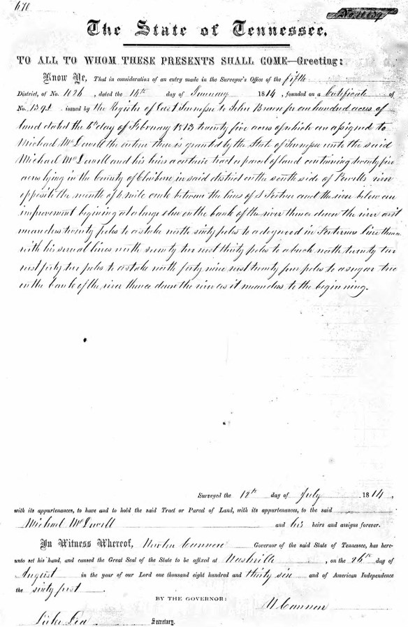
Land
In January of 1814, Michael was granted 15 acres plus 200 acres previously assigned to John Braham. Perhaps Michael had been living on John’s land ever since his arrival. Or maybe he settled on the land he eventually purchased, given that William Herrell’s land was right next door.

The great thing about Michael’s land grant is that it tells us exactly where this land is located.
District 6, Powell River by 4 Mile Creek and it’s bluff adjoining Herrell’s line beginning on the north bank of Powell’s River above the mouth of 4 Mile Creek then up the rivers…to the east bank of 4 Mile Creek…
Michael also received another 25 acres in the same location.

During one on my visits, I took these photos which I’ve assembled as a panorama, taken from the top of “Slanting Misery,” Michael’s land, looking left to right from the Harrell land to the Clarkson grant. In the next 3 generations, these families would intermarry and become my ancestors.
On February 1, 1817, Michael McDowell witnessed a deed for the purchase of land by his son, John McDowell. Another witness was William McDowell. This is the first instance of William McDowell in any record, unless you count the 1811 marriage in Pulaski County, Kentucky.
Although the land that’s being surveyed below isn’t Michael’s, it’s the best overview of the area and property owners that I’ve ever found because the drawing includes all of the families along Powell River. Notice the survery is for a Parkey, the same family as where church was being held. The Parkey’s owned significant land along the Powell River, including south of the river.


A current map shows the following locations. Before GPS and Google Maps, this is how we found land and locations. It worked!

Additional information is recorded in the Claiborne County Court Notes from the Court of Pleas and Quarter Sessions 1819-1821:
Thursday Nov. 11, 1819, Page 31 – John McDowell appointed as a juror to the next session.
Wed. August 16 1820, Page 162 – Ordered by the court that Alexander Ritchie be appointed overseer of the new road leading from the 9 mile post at Doherty’s to the Powell Valley Road at John Hurt that is from the said 9 mile post to Powels River and have for hands the following bounds that is all Capt. Thoms McCarty’s company south of Wallen’s Ridge and the following named hands on the N side of said ridge – William Herrold, John McDowell, Joseph Baker, William Baker, William Medlock, William McDowell and Robert G. (or C.) Parks.
I suspect Parks was really Parkey.
In 1824 Michael McDowell granted a deed to John P. McDowell in Claiborne County, for “love”. A second transaction was the reverse. Did these men trade land?
In these records, we need to differentiate between John McDowell and John P. McDowell, who were different men.
John McDowell’s 1825 survey was located on the far northern end of “Slanting Misery.”

William McDowell’s 1829 survey is shown below, adjacent William Herrell in the area that would be called Herrell’s bend of Powell River.

The 1830 census for Claiborne County shows:
Michael McDowell:
- 1 male 80-90 (Michael 83)
- 1 male 30-40 (unknown, born 1790-1800)
- 1 female 70-80 (wife about 77)
- 1 female 20-30 (unknown, possibly wife of male 30-40)
The unknown male could possibly be son William. Although William had land surveyed in 1829, he isn’t listed on the census.
Michael was living beside his son, John McDowell, age 40-50, so born between 1780-1790, with John’s 5 children.
They live less than a dozen houses from William Herald who married Michael’s daughter, Mary McDowell, in 1809 in Wilkes County.

Nathan McDowell is living in Claiborne County as well, but not close to Michael. He is age 30-40, so born between 1790-1800, as is John P. McDowell, age 30-40.
In 1832, we find another 50 acre survey for John and William McDowell, jointly.

The John and William McDowell 1832 4 Mile Creek survey mentions Michael McDowell as a chain carrier. In 1832, Michael McDowell was 85 years old. He must have been a quite spry 85, or maybe this Michael was a grandson?

John and William’s land was the north end of Slanting Misery, adjacent Michael McDowell’s land.
The map below shows the exact area as the survey above, including the location where the river is forded at McDowell Shoal with the red arrows. You can see the 2 tracks on the other side of the river, on Slanting Misery.

The land at the mouth of 4 Mile Creek is the land Michael sold to his granddaughter, Margaret Herrell and her first husband, Anson Martin. After Anson’s death, Margaret married Joseph Bolton and they became my great-grandparents. They probably lived right here.

River Road runs alongside Slanting Misery, across Powell River from Slanting Misery. Michael owned land on both sides of the river. The yellow arrow is the mouth of 4 Mile Creek, and the green arrows mark the two fords of the river today.

This view shows 4 Mile Creek, the fords and the barns on Michael’s land. Michael’s house stood near the barns and cemetery. McDowell Shoals is to the far right on River Road, above.

This high area along River Road, looking across the Powell River to Michael’s land is called McDowell Shoals. You can see the island in the middle of the river that used to support a swinging rope bridge.
On May 16, 1832, the surveyor surveyed 50 acres of land on both sides of 4 Mile Creek for Michael and the chainer was John McDowell.

Today, driving along River Road, we cross 4 Mile Creek just before it dumps into the Powell River. Michael owned this land.

By this time, Michael was 85 years old, and he’s still amassing land!
We know his age due to his application in court on May 17, 1832 for his Revolutionary War pension. It was no small endeavor to travel to the courthouse in Tazewell, either. That journey began with fording the Powell River, as map shows, which runs high in the spring, sometimes VERY high.

That trip to town probably required a couple days and equally as long to return. Michael and whoever went with him probably stayed in town during the week to attend court. The entire adventure to appear before court probably took a week or more. Not to mention that “court,“ which occurred quarterly, was the entertainment of the day. If you went to all of the trouble and effort of attending court, you were surely going to stay for the entire spectacle. Who wants to leave the movie at intermission? Court was the soap opera of 1800s Appalachia, with adult beverages flowing freely. Not to mention that Michael would have gotten to mingle with the other Revolutionary War veterans who were also applying for pensions. I can just see those old men telling stories and “swapping lies,” as my Dad would have said. Maybe over some whiskey at the tavern.
In 1833, a deed was granted from Michael McDowell to S. and W. (Nathan S. and William) McDowell “for love,” confirming a close relationship. I wish he had told us the exact nature of those relationships.
The Claiborne County 1833 tax lists shows Michael living beside William McDowell and William Herreld who lived 5 doors from John McDowell.

John McDowell obtained a grant in 1834 on the Powell River, just below the mouth of 4 Mile Creek.

And another grant in 1836. This family was a land baron! It’s just that the land was rough and not very productive.
I thought surely that Michael was finished obtaining land, but not according to the Tennessee land grant books found in the Middlesboro, KY library. In 1836, when Michael would have been 89, he was granted another 40 acres. I have to wonder if a lot of this land was “scrub” by this time, or others would have already patented the land had it been productive farmland.
| Last |
First |
Year |
Acres |
District |
Book |
Page |
Grant |
County |
| McDowell |
Michael |
1836 |
15 |
E dist |
8 |
669 |
70038 |
Claiborne |
| McDowell |
Michael |
1836 |
25 |
E dist |
8 |
669 |
70039 |
Claiborne |
The 1839 Claiborne County Tax list is in alphabetical order, not house order, and it tells us that Michael had 40 acres valued at $100, taxed at $5. There is another 60 acres listed as school and valued at $50 and taxes at 2.5. He has no poll, due to his advanced age, and under the tax column, it shows .05, which does not add up to the total of the previous columns, but then neither do the rest so I’m apparently misunderstanding something.
It appears that at least part of Michael’s land is missing, although that simply might mean that others were farming the land and paying the taxes. Some deeds could have been conveyed by hand and not recorded as well.
In his lifetime, Michael was granted a total of 330 acres. He conveyed land to John P. McDowell in 1824 for “love” and to Nathan and William McDowell in 1833, although the acreage is not stated.
Given that Michael obtained yet another two land grants in 1836 for 25 and 15 acres, and was taxed in 1839 for 40 acres, this appears to be the amount of land that Michael has left.
Anson Martin and Margaret Herrell
On June 20th, 1840 Michael McDowell along with William McDowell sold 2 acres of land to Anson Martin at the mouth of 4 Mile Creek for $50. Anson had married Margaret Herrell, Michael’s granddaughter, about 1828. I have to wonder why they only purchased 2 acres. That certainly wasn’t enough to farm. Would they have established a mill at the mouth of a creek?
At this time, Michael would have been 93 years old and it is presumed he died shortly thereafter since he is not listed individually on the 1840 census, and not listed on the Rob Camp Church membership in 1844. He is probably buried on his own land on Slanting Misery, close to the confluence of Four Mile Creek and the Powell River in what is now Hancock County, but like most of the early pioneers in this area, there is no marked gravestone to identify the exact location in the cemetery.
The Claiborne County 1840 census shows us that there are a John and William McDowell, both living near William Herral, with William McDowell having a female aged 80-90, possibly his mother.
Additionally, the Reverend Nathan McDowell who had moved further east in Claiborne County has a male living with him, age 80-90. Are these two elderly people Michael McDowell and his wife? Perhaps they both needed help, and two children each took one parent.
Or, maybe, just maybe, there was something else going on.
A Scandal
Michael McDowell’s son-in-law, William Herrell served in the War of 1812 not long after the family settled in Claiborne County. William came home, while many of their neighbors, including James Claxton, their neighbor who lived in the next river bend to the west, did not.
After the war, William Herrell and Mary McDowell Herrell continued to live on the land adjacent Michael, as they would until Michael’s death. From the distance of almost 200 years, life seems routine based on what few records exist. Deeds and court records, mostly, with a few tax records sprinkled in for good measure.
It’s in those tax records that we find the first hint of the scandal that must surely have enveloped the family, if not the entire community and possibly further.
William Herrell is taxed in 1836 and 1839 on land and a slave worth more than half the value of his land.
In the 1900s, the whispered story that William Herrell had two wives lived on, even into the late 1900s. Told in hushed voices so that children wouldn’t overhear. Of course, that made the savvy children strain to listen harder – thankfully – because it was one of those nearly 90-year-old children that heard her grandmother tell that story – and told me around the year 2000. Her grandmother KNEW the family involved, but wouldn’t say who, other than “William Harrell had two wives,” and then just clucked her tongue.
Of course, there were two unrelated Herrell families in the region during that time, our William Herrell who lived in the far north part of the county, and another Herrell family who lived in the far southern part of Claiborne County, bordering on Grainger County, about 30 miles distant. There was also a William Herrell in the Claiborne/Grainger group, my friend’s ancestors, but this rumor didn’t seem to pertain to him as he never owned slaves, which confused my 90+ year old friend. According to my friend, those two families didn’t realize they weren’t related back in time and (at least she) presumed they were because their names were the same.
It wasn’t until I discovered that “my” William had two wives that this persistently repeated story made sense. It was quite by accident that I discovered which Herrell family was involved.
I don’t mean that William had one wife who died and he then married a second wife, but that he had two wives at the same time. Technically, if not legally, bigamy. Not only that, but one wife was white and one was black. In that time and place, THAT might have been the bigger cluckable offense. Which also explains, of course, why this it wasn’t legally bigamy. Not only was it illegal for a white person to marry a black person, there was more to this story.
And no, William Herrell was not Mormon, so his actions were not religiously directed. In fact, not surprisingly, we don’t find any evidence of William in any church records.
Apparently, the white Herrell family and black Herrell family in northern Claiborne, the part that eventually became Hancock County, “always knew” they were somehow related, even though exactly how had been long forgotten, at least according to oral history from some of the family. Others, however, knew more. In fact, their oral history included the fact that Cannon, the son of Harriett, William’s slave, wound up owning some of William’s land via inheritance.
One thing is for sure – Cannon Herrell and the rest of the Harrell family all lived together, apparently harmoniously, along the Powell River for generations – including today.
Harriett Herrell was William Herrell’s slave, but at some point, as the story goes, she became his second wife according to my friend. Eventually, my elderly friend told me that when she was young, in the early 1900s, her grandmother, great-aunts and others still discussed the scandal of the William Harrell with the white wife and the black wife. She said that topic never got old, and all “those old women did was gossip about people.” Obviously a very interesting and unusual story to hold thier attention for so long.
William reportedly built Harriett a house on one side of his property, his wife Mary McDowell Herrell’s house on the other side, and he would live with one until she got mad at him and kicked him out. Then he’d live with the other until she got mad and kicked him out, when he’s go back and live with the other wife again as the circular scenario continued to repeat.
There is one part of the original story that doesn’t add up. That tidbit is that Harriett “had a whole passel of kids,” which she did not according to available records, or her descendants. There are no stories of Cannon having siblings other than Mary’s children. Of course, we don’t know how many children Harriet bore that might have died, or, God forbid, might have been sold.
A second problematic part from the Cannon family oral history is that William Herrell left Cannon land, which it appears that William did not. We know this in part because at the time William Herrell died, in 1859, intestate, Cannon was still legally a slave and William could not have bequeathed him land. That does not mean that in 1872, Mary McDowell Herrell couldn’t have left or given Cannon land. The deeds burned, so we’ll never know for sure.
However, Cannon did eventually own some of William’s land, living adjacent Alexander Herrell, his half-brother, although Cannon purchased the land outright. That deed occurred after the first courthouse fire.
Mary McDowell Herrell, William’s wife and Cannon’s step-mother, raised Cannon with her children after Harriett’s death and could certainly have left Cannon money when she passed, sometime after 1872. William did claim Cannon as his child, according to all parties, and Cannon carried the Herrell surname. Cannon is listed on the census with the family in 1870. In 1850 and 1860, he is listed as mulatto – one of only two people in that broad region. Cannon’s parentage was clearly no secret to anyone.
Cannon lived with Mary and her adult daughters until after Mary died. According to the census, Cannon seemed to be doing financially fine on his own – better than his stepmother and sisters combined. Mary owned the property, but Cannon owned more personal property than the women. It probably took the efforts of everyone, working in tandem, to farm and earn enough to survive, given the location of their farm.
How did I find Cannon?
In the 1830 census, William Herrell (spelled (Harold) did not own a slave.
In the 1840 census, William Herrell owned one female slave, with a male slave under the age of 10. That child was Cannon Herrell who was born between 1827 and 1838, depending on the record you reference. Keep in mind that slaves were taxed according to thier age, and younger males were taxed as a lower rate than older males.
On the 1850 slave census, Cannon is shown as age 12 and Harriett is gone.
On the 1860 slave census, Cannon is owned my “Mary Herrel and 5 others,” clearly her children as a result of William’s death in 1859, where Cannon is listed as age 33. That would put his birth in 1827, the earliest date we find.
In 1870, Cannon is living with Mary and his age is given as 35, putting his birth in 1835. In 1880, he has married and gives his age as 45.

Cannon’s death certificate in 1916 says he was illegitimate and doesn’t name a father which is not unusual under the circumstances, meaning a white man fathering a child with a black woman. It does list Cannon’s mother’s name as Harriett Herrell.
I considered that there was one other possibility, which is that William Herrell’s eldest son, Alexander, fathered Cannon with Harriett. Alexander, born on Christmas Day, 1820, would have been 16 or 17 when the child, Cannon, was conceived IF he was born in 1838. At this point, I think it’s more likely that Cannon was actually born earlier, possibly in 1830, given that the family actually had a full birth date which is recorded on Cannon’s death certificate. Other records indicate 1834, 1835 and 1837. Any date before 1838 would likely exclude Alexander.
In 1829, William Herrell’s white wife, Mary, bore her last child, Malinda. I would suggest that many tears were shed by both Harriett and Mary during those years. Both would have been trapped in a situation neither one wanted and neither could control. I suspect they spent a lot of time together.
Furthermore, if William empregnated Harriett once, it’s nearly certain that behavior didn’t cease. The behavior clearly wasn’t “common and accepted” because in 1850, Cannon was only one of two mulattoes listed in that region.
It was 1838 when Margaret Herrell Martin, William’s oldest child, and her husband, Anson Martin, requested to be dismissed from the Thompson Settlement Church. There was no “other church” to join at that time, in this region, which suggests they left the church for other reasons. I’d can’t help but wonder if it had something to do with the scandal which may have just been occurring and assuredly was hotly debated for a variety of reasons.
Slavery in Claiborne County was unusual, and slavery in this part of the county was almost unheard of, although in 1830, the Bales family who is listed adjacent William Herrell had one slave, and John Parrott, another two properties away owns a few slaves including a female slave of the age that could have been Harriett. By1850, Peter Parkey owned slaves too.
Just a few years later, these families would fight for the north during the Civil War.
In this part of Claiborne County, there was no flat land to be cultivated. Plantations were impossible. Slaves were few and far between, and when a landowner was found with slaves, it was generally one, or at most, two. Poverty was a common thread. No one had enough money for anything, let alone slaves – so William’s purchase of a slave between 1830-1836 is mystifying – especially having been to see his land and his family’s hardscrabble existence clinging to the river banks.
The portion of this article titled “Roberta and Mary’s Great Adventure” shows the Herrell property.
Given these circumstances, it’s not surprising that what occurred between William and Harriett was so scandalous, not to mention the strong primitive Baptist regional leaning. And poor Harriett, caught up in all of this. I can’t help but wonder if she died in childbirth, but there is absolutely no evidence of that.
Two years later, in 1840, Margaret and Anson bought the two acres from Michael McDowell. Were they trying to live someplace away from Margaret’s father’s land and the family drama? Granted, the land at the mouth of 4 Mile Creek wasn’t very far from her parents – but maybe far enough.
Did Margaret ask her grandfather to sell her two acres? Margaret’s parents were William Harrell and Mary McDowell, Michael McDowell’s daughter. Margaret’s brother was Alexander Herrell. Everyone lived in close proximity to one another.
Regardless of whether William Herrell or Alexander Herrell fathered a child with Harriett, Y DNA confirms that one of them did – and it was most likely William. I’d say almost certainly.
Regardless of which male fathered Cannon, William’s wife, Mary and her family may have been ostracized, especially at church, as a result. Harrell Bend and surrounding area was already quite remote and remains so today – it’s own microcosm.
Michael McDowell, Mary’s father, was certainly alive in the 1830s when Harriett gave birth to Cannon. I’m guessing, given that Michael never owned a slave and neither did any of his sons in Claiborne County, that Michael was not one bit pleased when William Herrell who was both his son-in-law and neighbor purchased a slave between 1830 and 1836, then (presumably) proceeded to cheat on Michael’s daughter with that slave.
This is the same Michael McDowell who beat Betty Wooton in Wilkes County in 1790 and was prosecuted more than once for trespass. Michael apparently had something of a temper, so I’m guessing it had abated somewhat by the 1830s – or he was just too old to do anything about the situation.
The slave, Harriett, probably had absolutely no say in any of this and was also a victim, in more ways than one. Slaves controlled absolutely nothing, including their own bodies. In 1838, William would have been about 50 years old and she was probably young.
To make matters even worse, the fact that Harriett was possibly purchased as a second wife compounded an already difficult situation. When Cannon was born, if William’s fidelity was ever previously in question, all doubt was removed. If Alexander was the father instead of William, which is not what the original oral history on either side of the family indicates, scandal would still have spun around the family, especially in the church.
Making matters even more sticky, Nathan S. McDowell, Michael McDowell’s son and Mary McDowell Herrell’s brother, was a Baptist preacher, described as having a “very crabbed disposition.” He had already purchased land in Claiborne County, but in 1837 he began serving as moderator of the Big Springs Baptist Church south of Tazewell, 18 miles distant.
This family was probably torn from stem to stern, although Nathan was reported to have refused to swear an oath of fidelity during the Civil War. Still, adultery is adultery and sin is sin, regardless. Not to mention the human emotions of Mary, Harriett and all the family members other than William who caused this mess.
Mary McDowell Herrell, about 50 in 1838, was probably EXTREMELY unhappy with her husband, to put it mildly. Betrayal is incredibly painful – especially if Mary suspected that William bought Harriett with that plan in mind and she could do absolutely nothing. Regardless of the circumstanced under which this occurred, William bore sole responsibility for being intimate with another woman – and “how” could have been even worse if the act was not consensual. For that matter, can a woman held in bondage to a man actually give free consent? I don’t think so.
Michael McDowell was elderly and probably also very angry with his son-in-law, William Herrell. He had obviously been close to William since at least 1810 and had spent the time since as neighbors on the Powell River.
Mary lost her husband’s fidelity in the 1830s (if not before) when William fathered Cannon, lost her father about 1840, her son-in-law (Anson) in about 1845, gained an orphan half-sibling of her children between 1840 and 1850 when Harriett died, as well as losing her husband, William, in 1859. Mary may not have grieved William’s death on a personal level, we don’t know. They had children and shared a lifetime together. They were economically tied and more work would have fallen on Mary and her children’s shoulders after his death. That 20 years or so of Mary’s life must have been living hell – and Michael couldn’t have helped but notice his daughter’s pain.
In the 1870 census, after William’s death and Cannon was freed, Cannon is still living with Mary McDowell Herrell and her adult daughters. That smaller family unit was reported to be very close. I hope so. They deserve that.
Nope, no family drama going on at Slanting Misery. Nada. Nothing to see here folks! Move right along. This has all the makings of a good soap opera. Downton Abbey’s got nothing on the McDowell/Herrell clan living on the Powell River.
It’s nothing short of a miracle that Michael McDowell who roughed up Betsy Wooten in 1790 didn’t personally put William Herrell into a grave for cheating on his daughter. Maybe Michael was simply too old (90 in 1837), or maybe that’s why Michael may have been living with Nathan in 1840. Maybe he tried. It appears that Isabel, Michael’s wife was living with William McDowell in 1840, unless that female is William’s mother-in-law.
Perhaps Michael got sent to live with the preacher son 18 miles away because the entire family felt everyone was safer with some distance between Michael and William Herrell. Or maybe the family simply hid Michael’s gun(s), much like we hid my mother’s car from her for her own (and others’) safety during her last few months.
I understand that William Herrell is buried in the Herrell Cemetery although there is no marker. I’m sure he would not have been welcome in the McDowell Cemetery if in fact Cannon was fathered by William Herrell. Mary’s brother, John, owned the McDowell Cemetery land when William Herrell died. I don’t know whether Mary is buried with William in the Herrell cemetery, or maybe she was buried in the McDowell cemetery, with the rest of her family. That decision rested with her children, and the decision may have been predicated upon whether Cannon was fathered by William (probably) or Alexander Herrell (probably not), along with whether or not William “repented” and if Mary forgave him.
Cannon’s family certainly believed he was fathered by William, and Cannon lived beside Alexander on the land he purchased, for the duration of both men’s lives.
It’s possible that this stress contributed to Michael McDowell’s demise – although he was clearly elderly.
Let’s visit the McDowell Cemetery on Michael’s land where he most assuredly rests.
Where is the McDowell Cemetery?
Michael McDowell’s descendants helped me find the old McDowell Cemetery on Slanting Misery, which was no easy task, I assure you. By looking at this tranquil land today, you’d never guess it’s storied history.
Let me begin with a letter from Mary Kay, married to (now deceased) Les McDowell, Michael’s descendant through son Luke.
This is Mary Kay. Michael McDowell is my husband Les’s ancestor.
Twice we have waded the Powell River to the Old McDowell Farm, in 1997 and 1999. The first time I photographed the gravestones there. The second time we took a large crowbar over there to turn over a big stone in hopes of seeing scratchings indicating that it was for Michael. Unfortunately, it was just a plain stone; no evidence of it ever having had anything on it. However, in “witching” the graves, there are definitely at least three other bodies there – two men and one woman. We think that Michael has to be one of the men, but I guess we’ll never know.
Grave “witching,” also called dowsing, a technique using a rod or stick often made of hickory is a very old technique used traditionally to avoid digging up existing graves when new burials were being dug, and more recently to locate old graves. It sounds ominous, but it wasn’t and isn’t. I grew up with this tradition which is also used to find underground water when wells are being dug.
Back to Mary Kay:
Mary Parkey, the historian for the Claiborne County Historical Society at that time, had the original deed to that land, in Michael McDowell’s name. I wanted to purchase the deed from her, but Mary wouldn’t sell it, but did provide a photocopy. The original was in the house fire that took Mary’s life a few years later, along with many other irreplaceable documents.
Mary Parkey, now deceased, was descended from both Margaret Herrell and Anson Martin, and Alexander Herrell.
Mary Kay sent a list of the names of the people buried in this cemetery surveyed in 1994. The name of the cemetery is Speer-McDowell and the location is given as the Bill Brooks Farm, formerly Edd Breeding. Locally, it was just called “The Old McDowell Farm” and as late as the 1990s, Joe Herrell still owned the adjacent farm at that time.
For nearly 200 years this land had remained in the same family.
- Hettie Greer (w/o R. L. Greer) b. 06-25-1892; d. 12-26-1918 (her mother was Mollie Thompson and her father was James Speer)
- E. Speer b. 11-29-1845, d. 01-13-1923 (James Edward Speer, son of John Roe Speer and Rachel Denton)
- Mary E. (Mollie) Speer (wife of J. E. Speer) b. 03-11-1873, d. 06-27-1914
- Hettie Edds, (w/o J. E. Speer) b. 11-19-1829, d. 02-05-1888
- R. Speer b. 1820, d. 18–?
- Caroline McDowell b. 01-16-1830, d. 10-04-1899 (daughter of John McDowell, no record of marriage)
- Surena McDowell b. 3-11-1826, d. 11-07-1893 (daughter of John McDowell, no record of her ever marrying)
- John McDowell, aged 94, d. 10-17-1817 (This year is incorrect, he died in 1877. Clearly the 7 was misinterpreted.)
- Nancy McDowell, aged 47, d. 12-03-1841 (means she was born in 1794 and is probably John’s wife)
Reconstructing the Family from a Letter
A letter from Mary Opal Herrell in 1997, when she was 80, said that her grandpa Jim Speers first wife was a McDowell and that he is buried in the McDowell cemetery between his first wife and second wife.
The 1880 census shows James Speer, age 33, living with Matilda, age 41, with daughter Elnora, age 7. Caroline age 47 is married to R.M. Tipton who works on the farm, and Bird Campbell, a male age 15 is a servant, along with Surena McDowell age 51, listed as a sister-in-law.
In the 1900 census, James Speers states that he is born in November 1846, age 52, and is married to Mary, born in March 1873, age 27. They have been married for 9 years, have 2 living children, Hettie born in 1892 and Leonidas born in 1893.
The second wife appears to be Mary Opal’s grandmother. Mary Opal’s mother died when she was just a year old in the flu epidemic. She said that John McDowell sold the land to Jim Speers. Mary Opal said that her Aunt Nora, Jim’s daughter from his first wife never accepted Jim’s second wife. Nora was “raised by the McDowell women.” Mary Opal Herrell appears to be the daughter of Hettie Greer who died in 1918.
In the 1870 census, James Spear, age 22, is living with John McDowell, who is age 89 (so born in 1781) and James apparently married John’s daughter, Matilda, by 1872. The Hancock County courthouse burned, twice, so the deed between John McDowell and James Speer which would have been conveyed probably between 1872 and 1877 when John died went up in flames.
Fortunately, between the cemetery records, the census and Mary Opal’s old letters, we reassembled the family, at least somewhat.
Visiting the Cemetery
Let’s visit the cemetery!
The first group of photos were provided by Mary Kay and show Mary Kay’s husband with a local gentleman crossing the Powell River and their discovery of the cemetery on Slanting Misery.
First, let’s look at an aerial view. The red arrow below marks the actual location where people drive or walk across the river when the water is low enough. It’s the only location accessible on both banks of the river.

After Michael lived here, a swinging bridge was hung across the river someplace in the area of the green arrow. I believe the tiny white dot in the center of the river just above the green arrow is the old foundation of the bridge on an island. The bridge was washed away decades ago in one of the legendary floods.
The photo below shows the men wading the river, marked by the red arrow above, and the gate on the Slanting Misery side. When I waded the river, the water was higher.

This next photo shows the group walking along Slanting Misery, roughly parallel with the river.

I had to visit the location twice. It couldn’t find the cemetery the first time, so Mary Kay sent instructions, which I’ve included below, although all of the buildings except the barn were gone when I visited.
The buildings are landmarks — if you didn’t see these you were not at the right place. You come to the shed first, and it will be on your left. Quite a ways further, the barn will be on your right. The cemetery isn’t far from the barn and will be on a hill on your left.

I never saw the barn the first time, and asked Mary Kay if she could provide additional instructions.
I’m wondering if you missed seeing it because you thought it was a more “structured” graveyard than just an area with stones. It is too bad that there wasn’t a fence around it, before the cows damaged the stones. The person who owns it has no connection with McDowells.
Mary Kay sent one photo of another landmark that I could use – assuming I could find the landmark.
The cistern and what looks like stones from a house foundation are “after” the shed, and I think, on the left on the way to the cemetery.

I strongly suspect that the foundation is that of the original house which was probably nothing more than a log cabin. It looks very small, but that was common then.

Finally, the cemetery. It was overgrown in 1997 when she visited and in 2004 when I visited as well.

The current Google map shows Slanting Misery.

The entire peninsula is between 2000 and 3000 feet long, and the Virginia/Tennessee border is about that far north of the northern tip of the Slanting Misery.
The next photo shows a closeup of the river ford and the barn.

Last, I believe the area with the red arrow is the cemetery. It’s difficult to correlate from the air, and several years later.

Michael Gets the Last Laugh
Never in my life have I ever managed to go on a “normal” genealogy adventure. There is always some unexpected twist or turn of some sort, and this time was no different. Ancestors truly do have a sense of humor – I’m totally convinced.
My first visit attempting to locate the McDowell cemetery was extremely disappointing. It was the dregs of summer and the thermometer hit at least 100 degrees. We were miserable. Had I any idea of the difficulty involved, I would never have attempted this, so it’s probably a good thing I didn’t know.
After crossing the river, I walked up the two track for a short distance, then made the mistake of climbing UP Slanting Misery. I thought from that vantage point, I would surely see the cemetery – because I couldn’t see it, or a barn, or anything from where I was.
You can’t tell from the aerial, but the center of Slanting Misery is really quite high in comparison to the perimeter. The reason the river carved out a peninsula is because Slanting Misery is a granite mountain with a little topsoil – but very little.
After climbing UP Slanting Misery, I knew immediately why Michael had named it that. The question remains WHY he purchased this land.
We had been cautioned about the cows when we obtained permission to visit, which is why there is a fence on the 2-track road into Slanting Misery, after crossing the river. At least, I think that’s why the fence is there. Maybe the cows ford the river too.
Regardless, we closed the gate carefully so there would be no bovine escapees.

My first glance of Slanting Misery gives no hint as to either slanting or misery. But across the Powell River lies both.
You can see the “driveway” on the other side of the river just beyond the tree branch, above. I was concerned about sinking in the mud and a rapid undertow. I can walk, and swim, so I didn’t want to risk driving and sinking.
This is literally the “front door” or “driveway” to this property. It’s the mountainous South – these kinds of things happen. The best or only way “in” is across the river. I was told there is an alternative, but it’s literally a half hour drive up and around and back down again – and it’s very difficult going. Better to ford the river.

Half-way across this river, looking upstream at McDowell Shoals, you can see what is left of an old island. The local people tell me that this was the location of an old swinging footbridge at one time. Apparently not everyone wanted to ford the river.
The words “swinging footbridge,” as in rope bridge, causes me to hyperventilate and sweat. I find that concept terrifying. The bridge washed out in a flood back in the 1970s, as I understand, but it had been there for years, as in decades, prior.
No one lives on this rather inaccessible land today – it’s used simply for grazing cattle.
The hill is high and the river over millennia has carved its way around the “bluff” made of granite. That’s the slanting part of Slanting Misery.
The misery part relates to the humans.

After climbing to the top of Slanting Misery, I naïvely thought I would be able to easily spot the cemetery. I mean, how difficult could this be?
The answer is – incredibly.
The photos below show a panorama of sorts, looking towards the Herrell lands to the left and then panning to the Clarkson land at the right.


During the first visit, I didn’t know to look towards the barn for the cemetery, nor did I realize that the cemetery was entirely grown up in vegetation.
I left empty handed, knowing I was so close, yet so far away.
I can’t believe I actually did this twice, on two separate trips. In fact, I intentionally went back to try this a second time.
Second Time is “Charmed”
My second experience a year later was somewhat different. Not only did I have photos and more detailed instructions from Mary Kay, I also enlisted the assistance of a local gentleman with the historical society who is also my cousin, Boyd.
Boyd grew up in this area and knew it well. I was so grateful that he agreed to accompany me.
Once again, we crossed the river, except, this time I decided to simply drive my Jeep. The water was lower than before, about knee high and I didn’t see any reason NOT to drive the Jeep. After all, that’s what Jeeps are made for, right?
After arriving on the other side, I turned the Jeep around, pointing it back in the direction from which we had come. I parked in the river, because there wasn’t anyplace else. We got out of the Jeep, quite pleased with ourselves, waded a few feet to the shore, opened and closed the gate, and proceeded to walk towards the barn, up the 2 track, which I had been assured, was within easy sight of the cemetery. I knew I could find it this time, and I wasn’t leaving until I did!
Boyd had never been there before, but he was certainly game, and off we went, determined to succeed – chatting about history and ancestors.
This land is so breathtakingly beautiful.

This is Slanting Misery, looking towards the Clarkson land.
On the way to the barn, I noticed what looked to be a historic trash pile and found a piece of metal, maybe from a tractor or piece of Oliver farm equipment.

I doubt this was Michael’s, but Michael lived here, near the well, near the cistern and near the barn. This was his domain for three decades.
The house had to be someplace very near this location. I think the stones beside the cistern from Mary’s photos were the house, but they were gone when I was there.
The green cedar tree on the far left, if you are approaching the barn, marks the cemetery.

The cemetery is really not a on hill, it’s more of a knoll.

You’d never know this is a cemetery if you didn’t know what you were looking for.
The condition was appalling, but it was sold outside of the family, AND, it’s very inaccessible. This photo was taken roughly 15 years ago, so the cemetery is probably in even worse condition today if it could even be located. The photos of the headstones below are a combination of Mary Kay’s photos and mine.

Mary Speers, wife of James.

The footstone for Mary Speers.

The stone for Hettie Greer.

John McDowell’s stone – barely legible.
Did you know that cows are really curious beasts?
Especially if they have come to associate humans with feeding time.

They noticed us in the cemetery and came to see what we were up to. Besides, in the cow’s world, it was THEIR cemetery and we were trespassing.
I grew up with cows and wasn’t the least bit worried.
Boyd, on the other hand, was getting increasingly nervous and said he thought we should begin walking back towards the Jeep.
I thought this was a bit odd because he was a farmer, but after all, he was the local person with experience. I was extremely reluctant to leave, because I wasn’t finished in the graveyard. Or at least I thought I wasn’t. I wanted to take a few more photos and I wanted to poke around and see if I could find a stone that might have been overgrown. Surely Michael was here someplace!
As it turned out, I really was finished.
Another cow approached Boyd, and Boyd started talking and backing. He shouted to me, “Come on, HURRY UP,” and he began to move quite quickly, then turned and ran. Then I began to run, because a cow had begun to chase us in a rather threatening way.
This cow had horns!!!
I realized that that was no cow, but was the bull, and he was protecting his harem from us.
At home, where I grew up – we borrowed a neighbor’s very happy bull. No one kept their own bull – and the neighbor’s bull was very happy because of that.
Worse yet, the bull was between Boyd and me, with Boyd in the lead and the bull following on his heels, which meant that when Boyd escaped, the bull would turn around, facing me and would be square between me and the fence.
Hopefully, Mr. Angry Bull just wanted to chase us off and meant us no harm. Hopefully! I really didn’t want to find out, AND you have to assume that any bull that is chasing you isn’t just wanting to say hello.
I had never been chased by a bull before…or since either for that matter. Not something I need to experience again in this lifetime – which I was just sure was destined to be ended momentarily.
It didn’t seem far from the river to the barn when we were walking IN and chatting, maybe a quarter to half a mile, but running back, being chased by a very large bovine, the distance to the gate seemed interminable. Worse yet, we had closed and latched the gate with a lock and chain.
I had absolutely no idea I could run that fast, or that far. Think of it as an impromptu stress test.
In 2005, I was looking at the half century mark and pole vaulting the gate wasn’t something I had in mind, but taking stock of my options, that suddenly seemed quite reasonable.
About 150-200 feet from the gate, Mr. Angry Bull veered off to the left into the brush – along what I now know is a second path. Boyd, somewhat older than me, but probably in much better shape, slowed down to a trot and I was extremely relieved. I had NO desire to turn around and go back. I did, however, desperately wish we had driven the Jeep inside the field instead of leaving it on the other side of the gate.
Boyd and I continued to trot and reached the gate. I, thankfully, was still holding my camera. The adrenaline still pumping, we sprinted over that gate and heaved a huge sigh of relief on the other side, seeing the Jeep waiting for us in the river near the edge, a few feet in front of the gate. We took a minute to catch our breath…until we realized Mr. Angry Bull was waiting for us, having taken a shortcut.
We were now trapped against the gate by the bull, with the bull between us and the Jeep, stamping his foot in the river, splashing the water.
I’m not sure if I actually audibly screamed, or if it was simply a silent scream of terror in my mind that happened.
I do know that the bull was MASSIVE and stomped angrily at us, having planted himself directly between us and the Jeep, expressing his disdain. I think he was drooling. His eyes might have been red and shooting flames too. Boyd and I began to play an insane game of ring-around-the-rosie with Mr. Angry Bull.
Swear to God on Michael McDowell’s grave – which I never found but am still sure is there.
Me, Boyd, my Jeep, the river and Mr. Angry Bull. Sounds like a country song. The only thing missing was a dog and a shotgun and we could have used the assistance of either or both at that moment.
The other problem is that once we reached the Jeep, we had to open the doors towards us, which means we had to step backward, with a bull in hot pursuit. Stepping backwards would have taken a second, or two, or three – but when you’re running away from a bull – seconds suddenly seem monumental.
In retrospect, I suspect that the bull was simply playing with us by this time. Irritated at the stupid humans. He clearly had chased people out of his field before, because he knew EXACTLY where the shortcut was located and how to gain the advantage at the gate.
The bull moved aside slightly, heading back for his shortcut. We dashed for the Jeep.
As we watched behind us for the bull to follow, charging again out of the overgrowth. The bull however, was already waiting for us, probably watching us watch for him – but he was watching us from BEHIND the gate already. If bulls can laugh, he unquestionably did. We surely looked as idiotic as I felt.
Make no mistake, that gate had absolutely NO EFFECT on that bull – he made that perfectly clear.
By the time Boyd and I finally got into the Jeep, I quickly turned on the ignition.
Thankfully, I had left the keys in the car, something I NEVER do. Thank Heavens, because there is no way on God’s green earth I was getting out and going back in that field to look for missing keys.
The adrenaline was rushing and I quickly threw the Jeep into drive and gunned the engine, heading across the river.
Too fast.
Yep, that river water sprayed right up into the engine compartment and drown out my engine. The Jeep lurched to a stop in a spray of water.
Dead!
Now, we’re sitting ducks in the middle of the river, and Mr. Angry Bull is going to have his way with us after all!!!!

Not that I want to tell tales on my cousin Boyd, but let’s just say that we looked at each other and both said the same thing at the same time – something that is not repeatable in church and would assuredly have gotten us censured in the Thompson Settlement Church of our ancestors.
Lord have Mercy.
We braced for what we knew was coming.
I wondered if the glass in the Jeep would hold?
Would Mr. Angry Bull use those horns to break through the windows in the doors or bust out the windshield?
Would he come through?
How much of him?
His whole body or just his head and those terrible horns the size of a house?
Would it help to get in the back seat? Could we even climb over? I wasn’t getting out, that’s for sure.
For God’s sake, how can you defend yourself from a bull?
There is no training for this.
I’ve seen those ugly photos of matadors gored by bulls – although they certainly deserved that they got.
Us, on the other hand, we were only guilty in “bull court” of getting too close to the harem.
Does that infraction receive the death penalty?
We braced!
Then….
nothing
Absolutely nothing.
Silence.
Dare we look?
Boyd and I kind of sat in embarrassed, awkward silence for a minute. Realizing how ridiculous we surely looked – and grateful that the only witnesses to our folly were each other.
The bull, quite pleased with his prowess, I’m sure, turned his back on us and headed back into the pasture to brag to the girls how successfully he had protected them.
They were probably already telling him how wonderful he was, fanning him and feeding him the bull equivalent of grapes.
Mr. Now Very Pleased With Himself Bull wasn’t the least bit interested in us anymore. He’d had his fun.
Thankfully.
Pondering what to do next, given that cell phones certainly didn’t work there, I asked Boyd if we should get out and begin walking to his house.
The answer was an emphatic “No!,” followed by a much calmer, “you might want to try the engine again.”
It’s hard to think clearly when you’ve just come within inches of having your life ended by a bull.
Vroom!
I slowly, VERY SLOWLY, drove back across the Powell River, onto River Road along McDowell Shoals, pretending nothing embarrassing had happened at all, and away from Michael McDowell’s Slanting Misery forever.
Michael’s Children
Michael’s children remain a real conundrum. Let’s take a look at what we know and what we don’t.
A few we know with varying degrees of certainty, one is iffy, and then there are two that are unknown.
In order to compile as much as possible about his children and probable children, I utilized the various tax, census and other records available when creating this chart.
|
First appears |
Birth Year |
1787 Wilkes |
1790 Wilkes |
1800 Wilkes |
1810* |
1820* |
1830 |
1840 |
| Michael Jr. himself |
Rev War 1777 |
1747 |
21-60 (40) |
>16 |
>45
Born before 1755 |
Lee Co tax |
|
80-90 |
80-90
1750-1760 With Nathan |
| Isbel – wife |
Son born 1782, pos son 1778 |
1750-1755 |
female |
female |
>45
Born before 1755 |
|
|
70-80
1750-1760 |
80-90 1750-1760 with William Herrell |
| Michael III |
1799 deed witness |
1765-1778 |
<21 |
<16
Born after 1774 |
Gone? |
Wilkes Co. to 45, 4 kids |
|
|
|
| John (wife Nancy d 1841) |
1810 in deposition |
1782 |
<21 (age 5) |
<16
after 1774 |
Gone? |
Lee Co tax |
|
40-50
1780-1790 |
50-59
1780-1790 |
| Edward m Pulaski 1811 |
1799 deed witness, 1811 marriage |
1774-1775 |
? missing |
<16 after 1774 |
Gone? |
Lee Co tax |
Pulaski
>45 (<1775) |
50-60
1770-1780 |
50-60 1780-1790 |
| James* |
1801 deed witness |
<1780 |
? missing |
<16
Born after 1774 |
? |
|
|
|
|
| Mary |
1809 Wilkes marriage to William Herrell |
1785-1789 (m 1809) |
B After 1787 |
female |
10-16 1784-1790 |
|
|
Clai-borne |
Clai-borne |
| Luke* m Pulaski 1811 |
1810 tax list |
1792-1797 |
B after 1787 |
|
0-10 1790-1800 |
Lee Co tax |
|
|
|
| William* |
1817 doc, or 1811 marriage |
1795* |
B After 1787 |
|
Missing ? |
|
|
30-40
1790-1800 |
40-50
1790-1800 |
| Nathan S. |
1833 deed from Michael to Nathan |
1797* |
B after 1787 |
|
0-10
1790-1800 |
|
|
30-40
1790-1800 |
40-50
1790-1800 |
| Female |
1800 census |
1790-1800 |
|
|
0-10 1790-1800 |
|
|
|
|
| Female |
1800 census |
1790-1800 |
|
|
0-10
1790-1800 |
|
|
20-30
1800-1810 |
|
*Nathan is born in 1785 if oral history of him being 80 and refusing to take oath at Cumberland Gap is accurate. 1790-1800 if census is correct. Based on other records, I suspect the census is correct.
*William witnessed deeds in Claiborne from 1817 on. Born circa 1795 from census records. If this is the same William, he was married in 1811 in Pulaski County, KY.
*1810 Claiborne County, TN and Lee County, VA census lost
*1820 Claiborne County census lost
*Nathan McDowell, ‘precher” is found in Owsley Co., KY in the 1850 census, age 53, born in Tennessee and Easter McDowell, age 52 born in NC. This puts his birth in 1797.
*William born in 1795 is age 55 in 1850, born in NC wife Sally, age 50, is gone in 1860. Sally is not the wife of William McDowell married in 1811 in Pulaski Co., KY.
*Luke is found in DeKalb County, TN in both 1860 and 1870, placing his birth date in 1797.
*1833 Michael deeds land to Nathan and William, for “love”
*James witnessed a deed in 1801, but never appears in a record again.
The problem when trying to reconstruct Michael’s family is that two males appear to be missing from the 1787 census, along with conflicts in the 1800 census as well.
Were the records wrong? Were his sons living elsewhere? Or were these men not all Michael’s sons?
Let’s see what evidence we have for each child or potential child.
Michael McDowell III
Michael’s oldest son was probably his namesake, Michael.
Michael McDowell III, likely son of Michael McDowell Jr. is first found in Wilkes County signing as a witness for Michael McDowell, his father in 1799. In 1802, Michael McDowell III is noted as Michael McDowell Jr. when appointed as a constable with Michael McDowell Sr. providing his security. As late as the 1810 census, Michael III is present in the county with 4 children, but disappears from the records before the 1820 census.
James McDowell
If James is Michael McDowell’s child, he only appears in one 1801 record. I classify this as very weak evidence, but it remains a possibility. He may have died. James is not a name that repeats in Michael’s family.
Edward McDowell
There is genetic confirmation that Edward McDowell who was born probably after 1774 and before 1778 was the son of Michael McDowell Jr. Edward signed the 1799 deed for Michael Jr. along with Michael III. Edward serves as a juror in May of 1804 in Wilkes County,
Edward was noted on the 1810 Lee County Tax list beside Michael McDowell Jr. and Michael’s son, John. The next year, Edward married Lucy Harris in Pulaski County, KY where he is listed through the 1840 census. According to these documents, Edward was apparently born sometime between 1774 and 1781.
Edward’s children are:
- Martin McDowell
- Mariah McDowell b c 1812 Married Stephen Hail and then Moses Roberts
- Sarah McDowell b c 1814 married Archibald Haynes
- Michael McDowell b c 1816
- Eliza McDowell b c 1818
- Montgomery McDowell b c 1820
- Son b c 1822
- Thomas McDowell b c 1824 married Seleta McDowell (said to be his first cousin, the daughter of Luke McDowell,) then 2nd Vernettie Fisher
- Franklin McDowell b c 1826
- Son b c 1828
- Son b c 1831
- Son b c 1833
Edward is reported to be the brother of Luke McDowell and Edward’s son reportedly married his first cousin, Luke’s daughter.
Edward died in January 1858 in Pulaski County, KY.
Luke is confirmed to be Michael McDowell’s son via Y and autosomal DNA testing.
Edward’s descendant matches Luke’s on Y DNA and other known descendants on autosomal.
John McDowell
April 30, 1783 – October 7, 1877, according to his tombstone.
In the 1850 census, John’s birth state is shown as Tennessee, which we know cannot be correct. Tennessee wasn’t a state until 1796, to begin with, and we know that Michael McDowell Jr. was living in Virginia in 1783. John’s 1860 census shows his birth location as Virginia, 1870 shows that he was born in North Carolina.
Roll the dice, take your pick!
John McDowell filed an affidavit in 1872 stating that he was 90 years old and had been acquainted with both William Herrell and Mary McDowell before their marriage, stating that he was at their wedding in 1809 in Wilkes County.
John McDowell further states in his affidavit that he left Wilkes about 1810 and that Mary and William were married about a year before that. We have every reason to believe that William Herrell and Mary relocated about that same time (probably in the same wagon train) to Lee County or the Powell River area of what was then Claiborne County.
This puts John’s birth in approximately 1782. The census later shows his birth as 1781. His gravestone when it was still legible reportedly said he died October 7, 1877, age 94 years, 5 months, 7 days, which means his birth calculates to April 30, 1783.
John’s wife is reported to be Nancy, surname unknown, which is confirmed by the headstone in the McDowell cemetery.
In 1830, John is shown on the census beside a Henry McDowell. I wonder if this is another son of John.
In the 1850 census, John is shown with the following family members:
- Hill McDowell (probably Hillary, male, age 25)
- Surrena McDowell – 22
- Matilda McDowell– 21
- Caroline McDowell – 20
- John McDowell– 18
John, age 18 in 1850 was born February 12, 1833 and died on February 17, 1895 in Lee County, Virginia. He married Susannah Jones and they had 7 children, including three males, below:
- T. Clinton “Clint” McDowell who married Gertrude Smith in Kentucky in 1900.
- James Hillary McDowell born 1861, married Nelly Flanary and died in 1959.
- John Ervin McDowell born 1871, married Alpha Jesse and died in 1951.
James Hillary McDowell had 4 sons, Willie born 1892, Hubert born 1987, Walter born 1904 and Paul born 1911.
John Ervin McDowell had 8 sons, Fred born 1905, Rylie Columbus born 1906, James Elmer born 1908, Robert Lee born 1909, Marvin Richard born 1911, George Ervin born 1914, Albert Jesse born 1918 and Lawrence William born 1924.
The 1994 Hancock County family book includes an article by Lyle McDowell and reports that John McDowell’s daughters, Surena and Caroline never married and are buried on the farm with John and his wife, Nancy.
From Lyle McDowell, John McDowell’s children other than Hill, Serena, Matilda, Caroline and John include:
- William Franklin McDowell who moved to Owsley County, KY about 1840, along with his brother Irvin. Lyle indicates that William Franklin is his great-grandfather.
- Irvin McDowell (July 7, 1825-Octoer 9, 1882) Hamilton Cemetery, Hamilton County, TN
Lyle also reports that John’s son, John, born 1833 moved to Lee County, VA, which is accurate.
John P. McDowell
John McDowell born in 1783 is not the same man as John P. McDowell who sells land in 1838 on Strait Creek in Claiborne County. That land in the deed is noted as where John P. McDowell lives. That deed is witnesses by a Capps male, suggesting a relationship with Nathan McDowell and his wife, Esther Capps.
In 1824, Michael McDowell deeds land to John P. McDowell “for love.” It appears that John P. is not Michael’s son, because Michael already has a son John, so this is probably Michael’s grandson. Furthermore, on the 1836 and 1839 Claiborne County tax lists, both John and John P. McDowell are listed, and they do not live close to each other. John lived adjacent Michael, but John P. does not.
John P. McDowell was born about 1799 in TN (according to the census) and died in Buchanan Co., MO, after the 1870 census but before 1880. He married Rebecca Capps in 1821 in Grainger County, TN, the neighboring county south of Claiborne. He had sons:
- William McDowell born in 1825
- John Pryor McDowell born in 1831
- Jacob Y. McDowell born in 1836
- David McDowell born in 1844
Given that the older John McDowell was the son of Michael McDowell Jr., this John P. McDowell was probably being raised by the McDowell family because he was closely related, probably Michael’s grandson.
John P. McDowell was clearly associated with Nathan S. McDowell but could not have been Nathan’s child given that they were only about 5 years different in age. My guess would be that John P. McDowell is the son of Michael’s son, Michael McDowell III who disappears from the records in North Carolina after 1810 but before 1820. Or, John P. could be the son of James McDowell who disappears in Wilkes County after 1801 – meaning that Nathan was John P. McDowell’s uncle. Given that Nathan had no children, he would be a good candidate to raise an orphan nephew. This is purely speculation but they had to be connected somehow.
What is certain is that Michael McDowell would not have deeded John P. McDowell land “for love” if he weren’t somehow closely related.
A Y DNA test on a male McDowell descendant of John P. McDowell would be quite interesting in that it would (hopefully) match one of the McDowell lines. I would love to compare the Y DNA of a John P. McDowell descendant to a male McDowell descended from John McDowell who died in 1877 in Hancock County or other McDowell males that have tested.
John’s Photo – But Which John?
Lyle McDowell provided the following photo, but as you can see, the 2 John McDowell’s are likely conflated, meaning John born in 1783 and John P. McDowell born in 1799. Many of the genealogy trees on Ancestry have done this as well.

I don’t know if this is the John P. McDowell who died in Missouri before 1880, or the John McDowell in Claiborne/Hancock County born in 1783 and who died in 1877. Given that this man’s hair is black, and the camera wasn’t even in use until after the Civil War, I question the providence of the photo. I’m suspecting that it came from the Hancock County McDowell line, given that’s the focus of Lyle’s research and that Lyle simply added the middle P. in error, not realizing that there were actually two separate men.
I wonder if this might be the older John’s son, meaning John McDowell born in 1833. If that John born in 1833’s photo was taken when he was ago 50 or 60, in 1883 or 1893, the black hair would be more readily acceptable than a photo taken of John McDowell born in 1783 who would have been about 87 in 1870, the first practical time for this photo to have been taken, and this John in the photo has entirely black hair. That’s hard to believe at about age 87. It’s also possible that the photo had been “restored” but his eyebrows don’t appear to have been modified.
Regardless, it’s probably the closest we will ever get to seeing Michael McDowell Jr. through the face of another McDowell male. If this is John born in 1833, he is Michael McDowell’s grandson.
Did Michael McDowell Jr. resemble this John? I’d wager that he did, at least somewhat.
Mary McDowell
Mary McDowell was born about 1787 and married William Herrel in 1809 in Wilkes County. You can read her story here.
William McDowell
William is presumed to be a son of Michael because William is found consistently with Michael in the Claiborne County records beginning in 1817. Of course, there is also a William marrying in 1811 in Pulaski County. If William was actually born in 1795, per the 1850 census, then the 1811 William marrying in Kentucky can’t be this William because he would have only been 14 at the time. However, if William was actually born in 1790 instead of 1795, then he could have been the male in Pulaski County in 1811.
Some William McDowell is married in 1811 in Pulaski County, KY to Anna Herrin. (Luke and Edmon are also married in Pulaski that same year.) We find nothing more about William in Pulaski County, but a William McDowell does appear back in Claiborne County TN about 1817. Of course, the William born in 1795 also comes of age that year, so what happened to the William who married in Pulaski County in 1811 is uncertain, as is his identity.
In 1828, William McDowell deeds his land grant in Herrell bend to William Herrell.
Michael McDowell deeds land to William and Nathan in 1833 “for love,” so there is little question that William is his son or at least very close kin.
One of the last documents signed by Michael McDowell is jointly signed with William conveying land to Anson Martin on June 20, 1840. We don’t know who William’s wife is, but in the 1840 census, he has a female of age 80-90 living with him. Chances are good that that female is either his mother-in-law or Isabel, Michael McDowell’s wife.
In 1850, William McDowell is noted as age 55, being born in NC and had no children living in the household. His wife is Sally, age 50, so not Anna, the name of the wife in 1811 in Pulaski County, TN. It does not appear that William had any children.
Luke McDowell
Luke was born about 1792 in North Carolina and died in 1879 in DeKalb County, TN. He is listed on the 1810 tax list of Lee County Virginia with Edward, Michael and John McDowell.
In 1811 in Pulaski County, Luke married Francis Field.
In 1850 in Dekalb County, Luke is noted as a blacksmith and age 58, placing his birth date as 1792 in North Carolina. In 1860, he is age 68 and also shows his place of birth as North Carolina.
Luke’s children are:
- Curtis McDowell born February 1810 died 1882, married Margaret Jadwin
- William Field McDowell born September 1811 died 1861 in Illinois, married Mary Gott and then Deborah Test
- Cynthia McDowell born 1812 died 1890, married Joseph Cantrell
- Kitty McDowell born circa 1814 died 1840-1850, married Thomas Rigsby
- Son born circa 1816
- Son born circa 1818 married Margaret
- Seleta McDowell born circa 1825, married Thomas McDowell (son of Edward) circa 1848
Luke’s descendant through son William Field McDowell, son John Benjamin McDowell, son Luke Bradley McDowell, son John William McDowell and 2 more generations has confirmed Luke as the son of Michael using both Y and autosomal DNA.
Luke’s Y DNA matches that of Edward.
Luke and Edward’s descendants autosomal DNA matches that of Michael’s descendants in Claiborne County through John McDowell and Mary McDowell Herrell.
Nathan McDowell
Michael’s presumed son Nathan S. McDowell was born about 1797, according to the 1860 census.
Nathan married Esther Capps (born 01-19-1798 died 03-02-1892) of Grainger County, TN. She was the sister of John Capps. They are not known to have any children.
In 1833, Michael McDowell deeds Nathan land, along with William McDowell, “for love.”
Nathan was a school teacher and minister of the Baptist denomination. A sketch of his life appears in the book “Old Time Tazewell” by Mary E. Hansard.
In Mary Hansard’s book, she states that Nathan was reported to have refused to take an oath of allegiance to the North, at Cumberland Gap, during the Civil War. He was taken to a northern prison where he died shortly, about the age of 80. His wife was apparently very proud of his bravery and how he died. However, that doesn’t exactly correlate with the census research, given that he was already living in Kentucky prior to the Civil War and wouldn’t have been 80 until 1879, long after the Civil War was over. I don’t find him in the 1860 census.
Minutes of Davis Creek Church in Speedwell in Powell Valley 1797-1907
- Nathan S. McDowell made application for letter of dismissal for Sister Hannah (no date)
- 1840 received elder Nathan S. McDowell by letter
Prior to that, beginning in 1837, Nathan was the moderator at the Big Springs Baptist Church, south of Tazewell, shown today below at the intersection of Lone Mountain Road and Riddle Lane.

In the 1850 census, Nathan is living in Owsley County, KY, noted as a “precher” born in Tennessee, age 53, and his wife is Esther, born in NC.
It’s possible that Nathan was not Michael McDowell’s son, but his grandson. Nathan is closely associated with John P. McDowell who we know is not Michael’s son. These two men are about 5 years different in age. If Michael’s oldest son was Michael III, born in 1778 or earlier, Nathan born in 1797 could have been his son along with John P. McDowell.
Michael III disappears from Wilkes County after the 1810 census where he has 4 children, including 2 males under 10. The under 10 designation doesn’t fit exactly, but is a possibility.
Nathan S. McDowell and John P. McDowell are the only two McDowell men who are clearly connected with Michael who live in Claiborne County, but distantly. Both married Capps women. It’s possible that Nathan, who was childless, raised his nephew.
Children Summary
In summary, Michael’s confirmed or most probable children are:
- Michael McDowell born between 1774-1778, either dead or gone from Wilkes County by 1820 (confident, but not confirmed)
- Edward McDowell born circa 1774-1780 (confirmed)
- John McDowell born 1782 or 1783 (confirmed)
- Mary McDowell born 1787 (confirmed)
- Luke McDowell born circa 1792 (confirmed)
- William born circa 1795 (confident, but not genetically confirmed)
- Nathan S. McDowell b 1797 (probably son, related in some way)
- Daughter born between 1790-1800 (no further information)
- Daughter born between 1790-1800 (no further information)
Possible children are:
- James born before 1780 (unlikely)
The Unidentified Children
There are of course, two unknown daughters in the 1800 census. It’s possible that neither reached adulthood.
What Does DNA Say?
In 2004, Lewis McDowell, a now-deceased descendant of Edward McDowell who settled in Pulaski County, KY tested his Y DNA. Lewis was a long-time genealogist, then 93 years old, pictured here with his lovely wife the day he contributed his DNA, and welcomed the opportunity to participate.

Lewis’s genealogy reflects that he descends from Edward, the son of Michael McDowell Jr. Amazingly, there were only two generations between Lewis and Edward McDowell who married Lucy Haines in 1811 in Pulaski County, Kentucky.
I wanted to compare Lewis’s Y DNA results with other McDowell male descendants of Michael through other sons.
Since Lewis McDowell’s death, he has since accrued Y DNA matches with three other McDowell males, all confirmed descendants of Luke McDowell.
Autosomally, many descendants of Michael McDowell Jr. who died circa 1840 in Claiborne County match each other, including Lewis, descendants of Luke, John and Mary McDowell Herrell, confirming their genetic connection.
Perhaps the best thing we can do for MIchael now is to find and confirm his children. I’m still looking for the children of his eldest son, Michael III, son William and potential son James, if in fact, James had children and was Michael’s son. We know that son Nathan didn’t have children, so we can’t confirm him genetically. There are no known children for William, but that doesn’t mean they don’t exist.
If you descend from any McDowell that is or might be connected, please check your autosomal matches, especially at Family Tree DNA where several known family members have tested. If you are a McDowell male, please take the Y DNA test at Family Tree DNA.
I’d love to hear from you!
______________________________________________________________
Disclosure
I receive a small contribution when you click on some of the links to vendors in my articles. This does NOT increase the price you pay but helps me to keep the lights on and this informational blog free for everyone. Please click on the links in the articles or to the vendors below if you are purchasing products or DNA testing.
Thank you so much.
DNA Purchases and Free Transfers
Genealogy Services
Genealogy Research
Like this:
Like Loading...


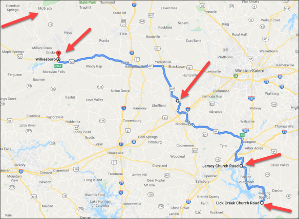


 Some of my most popular articles are the instructions for how to download your DNA files from the various vendors in order to upload and transfer your DNA files to other vendors to obtain more matches.


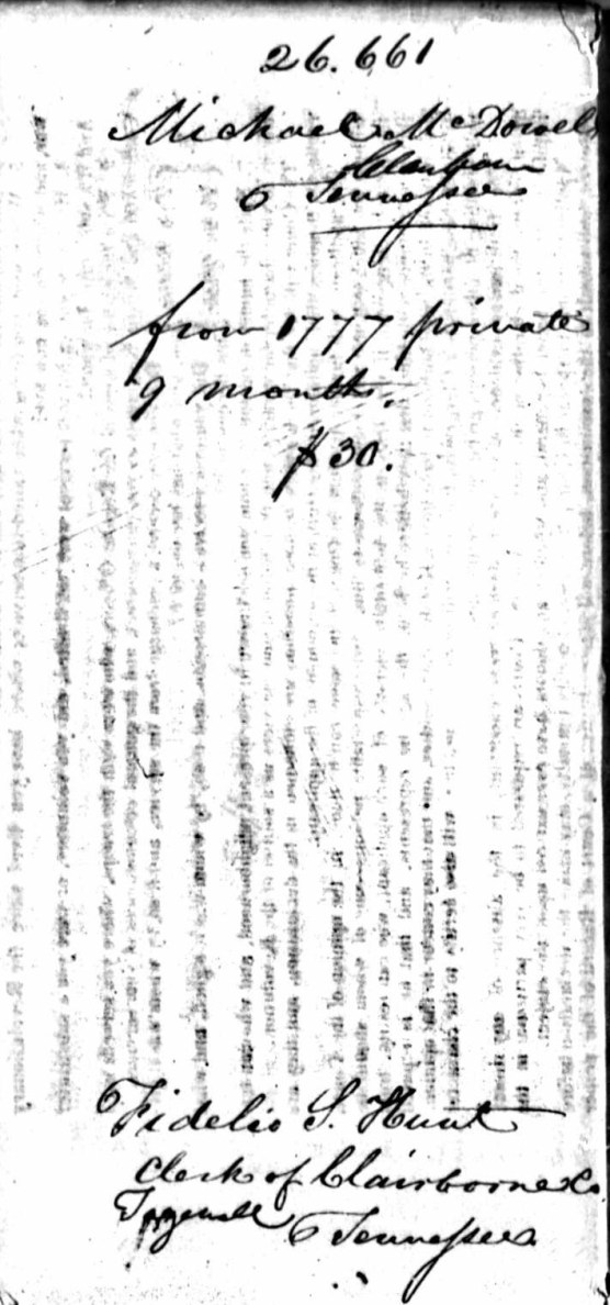


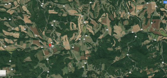


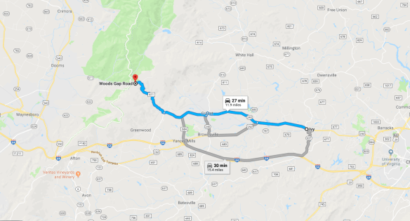


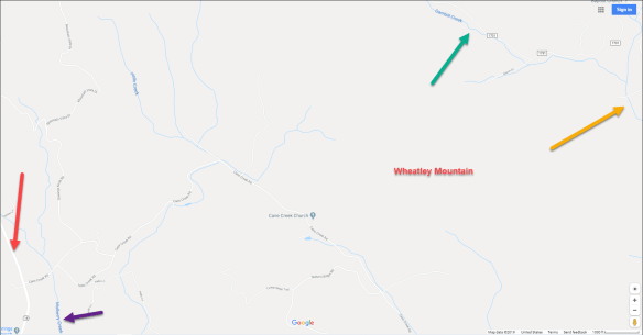


