The 1 Million Mark and Effective Matches

one million

Last week, Ancestry.com announced the millionth customer in their autosomal data base.  On January 18th, 23andMe did the same.  I don’t have exact numbers from Family Tree DNA, but they can’t be terribly far behind.  So, let’s look at the effectiveness of these matches at the roughly 1 million mark between the various vendors.

comparison chart

Black bold highlights the vendor’s positive aspects and red bold notes the drawbacks and places where each vendor could stand improvement.  I’ve underlined the two red issues I feel are the most serious.

*1 – Both 23andMe and Ancestry provide communications with others whom you match through internal message systems.  However, you have to request permission at 23andMe with anyone you match to communicate with them, and then additionally to share their DNA.  The 23andMe the 1404 number is how many people I match and the 162 number is the number of people that have accepted communications from me.  Not all of those 162 are sharing DNA.

*2 – At 23andMe, this would be the number of people sharing DNA results with me.  Ancestry has no tools that allow comparison of DNA segments.  At Family Tree DNA this would be all of my matches.

*3 – 23andMe cuts your matches off at 1000 unless you are communicating with your matches or you have an outstanding “introduction sent” request.  Of the 1404 people I match, 138 are sharing genomes, 24 have accepted communications but have not shared genomes, and 12 have declined.  The balance of my 1404 are either those to whom I’ve requested an introduction and they haven’t replied at all or some that I haven’t gotten around to inviting yet.  Ironically, my last of 1404 matches (in percentage of shared DNA order) is my known cousin who would have been purged had we not been sharing genomes.  You don’t have to send introductory invitations to those you match at either Family Tree DNA nor Ancestry and neither of those companies have an arbitrary cutoff, although Ancestry.com did a massive match purge when they implemented phasing.

*4 – At 23andMe, I can request to communicate with all 1404 people I match.  Of those, 162 have agreed to communicate or share genomes.  I can only communicate with those 162 people.  That doesn’t compare very well to either 1040 nor 5481 – and it shows how much genealogical benefit I’ve derived from 23andMe as compared to both Ancestry and Family Tree DNA.

*5 – At Ancestry, a minimum level subscription is required at $49 per year to see matching trees.  Not all participants have trees uploaded, and many trees aren’t public, so are not available for tree matching.  Otherwise, all trees connected to DNA results are included in matching function.

*6 – At Family Tree DNA, testers are encouraged to upload GEDCOM files or create trees in their account, and matching surname hints are given, but no actual ancestor matching in trees is performed.  Each participant must look at the tree of their matches, if provided.

*7 – 23andMe no longer hosts family trees on their site.  They have entered into collaboration with subscription service, MyHeritage.  Family Tree DNA is the only one of the vendors who hosts their own trees and does not require an additional subscription for that service, or for tree matching.

*8 – I have fewer matches at Family Tree DNA now than I did in November of 2014 when I had 1875 matches.  I have submitted a query to Family Tree DNA and they assure me this match number is accurate.

Commentary

The disparity between the 23andMe and Ancestry match numbers, since both vendors have 1 million autosomal results in their data bases, is suggestive of how many matches may have been pared from my match list at 23andMe.

The number of effective matches that can be usefully utilized, and how they can be utilized, are quite a bit different than the total number of matches implies without further analysis.

Both Family Tree DNA and Ancestry have unique strong points that make them stand out as vendors.

23andMe, since I can only work with or communicate with about 10% of my matches, is the least useful, for me, for genealogy.  I found their health services, which 23andMe is no longer allowed to offer following a dust-up with the FDA, very beneficial.

The tree matches and DNA Circles at Ancestry are very useful, but the fact that Ancestry provides absolutely no tools such as a chromosome browser or the other comparison tools that both 23andMe and Family Tree DNA provide makes Ancestry’s tree matches terribly frustrating eye candy in the candy shop behind a hermetically sealed window we can’t get through.  Tree matches and Circles are suggestive of an ancestral connection, but without comparison and triangulation tools, your match to an individual could be through a different, potentially unknown, line, and you have no tools at Ancestry to confirm or deny.  People are left to assume that the tree matches and Circles are proof, and unfortunately, they do in droves.

Thankfully, Family Tree DNA accepts transfers from Ancestry, V3 chip transfers from 23andMe (not the V4 chip since Dec. 2013) and GedMatch accepts files from all 3 vendors.  Those are the only avenues to actually compare the DNA of those who tested at Ancestry to triangulate and prove ancestral matches.

The great news in all of this is that more than 1 million people have tested, and probably more than two million in total – although there is clearly some overlap between vendors.  With every person that tests and that we match in one place or another, it increases our odds as genealogists to confirm our genealogy or break through those pesky brick walls.

Footnote:  The prices for the tests are the same, at $99, unless a sale is taking place at one of the vendors.  Both 23andMe and Ancestry also sell the aggregated anonymized DNA data for other purposes.  Both 23andMe and Ancestry will request that you sign (digitally authorize by clicking a box) an informed consent agreement for your non-anonymized (or less anonymized) data to be utilized or sold as well.  Family Tree DNA is the only one of these three firms that does not sell your DNA data in any form.

______________________________________________________________

Disclosure

I receive a small contribution when you click on some of the links to vendors in my articles. This does NOT increase the price you pay but helps me to keep the lights on and this informational blog free for everyone. Please click on the links in the articles or to the vendors below if you are purchasing products or DNA testing.

Thank you so much.

DNA Purchases and Free Transfers

Genealogy Services

Genealogy Research

First Peoples Series on PBS

first peoples

If you missed the First People’s series on PBS, all 5 episodes are available in full on YouTube.

The 5 are:

  • Episode 1: The Americas
  • Episode 2: Africa
  • Episode 3: Asia
  • Episode 4: Australia
  • Episode 5: Europe

These are well worth your time and include very interesting DNA results from ancient people and how they are related to us today.

______________________________________________________________

Disclosure

I receive a small contribution when you click on some of the links to vendors in my articles. This does NOT increase the price you pay but helps me to keep the lights on and this informational blog free for everyone. Please click on the links in the articles or to the vendors below if you are purchasing products or DNA testing.

Thank you so much.

DNA Purchases and Free Transfers

Genealogy Services

Genealogy Research

Jotham Brown (c1740-c1799), Maybe a Dissenter, 52 Ancestors #81

Blue Ridge

I love it when I tie into a line that has been well researched.  It doesn’t happen very often, but when it does, it’s definitely time for that happy dance.

I also love it when my ancestor has a really unique name.  Enough already with these Johns and Williams. I love the name Jotham.  I had never heard it before, outside of the Bible, before I found Jotham Brown, or better put, before I found Stevie Hughes who helped me find Jotham Brown.

We believe Jotham was born about 1740, but we don’t find any records until Jotham is in his late 30s, in 1778.  He could have been born somewhat earlier, probably in either Pennsylvania or Virginia, given the migration history of the other families where he is first located.

When Jotham was a child, the French and Indian War, also known as the Seven Years War, took place from 1754-1763 and involved both Pennsylvania and Virginia.  Not only was the land involved where Jotham most likely lived, but the conflict was protracted and often involved raids and attacks on settlers.  In many places, it was a time of fear and uncertainty.

French and Indian war

“French and indian war map” by Hoodinski – Own work. Licensed under CC BY-SA 3.0 via Wikimedia Commons – https://commons.wikimedia.org/wiki/File:French_and_indian_war_map.svg#/media/File:French_and_indian_war_map.svg

Of course, without knowing exactly where Jotham lived during that time, we can’t tell what he might have seen or how involved his family might have been.  Most healthy men in that timeframe served in the local militia, at least, which was then drafted for more active service during times of conflict or war.  Depending on his age, he could have served and his father most assuredly would have in some capacity.

Hampshire County, Virginia (now West Virginia)

The very first record we find of Jotham is in the Virginia Northern Neck Land Grants.

“Jotham Brown researchers may be interested in several deeds in Hampshire County Virginia, all of which can be found on line at the Library of Virginia. Jotham was very busy on Oct. 8, 1778.  He helped survey three tracts of land.  One can be found by looking up Frederick Royce 1789, (land surveyed earlier) and another is on surveys no. 21788-1794 page 87, and a third was on page 87 same survey no. 2.  Jotham Brown is named in a deed and survey done for John Berkeley grants R, 1778-1780 P. 170-171.  In the John Berkeley survey Jotham bought his land from John Royce. They lived on Spring Gap Mt.  John Royce was from Frederick county.  A John Brown from Frederick and a John Brown from Philadelphia are around the same community.  Hampshire records are not intact but an order book that starts around 1762 is at Library of Virginia.”

Thank you Mark Sampson for posting that information.  It’s very useful and helps us locate Jotham’s land.

A 1788 Hampshire County deed mentioned Frederick Royce (Rice’s) land on Great Capechon which is close to Spring Gap Road, as we’ll see in a minute.

Little Capecon (left arrow below) and Great Capecon (both right arrows) are both tributaries of the Potomac River.

Hampshire map

Although they are maybe 4 miles as the crow flies, the crow has to fly over a mountain range between the two, so while they are close, they aren’t direct.

Hampshire map 2

It’s pretty rough country.  Jotham Brown was obviously not intimidated by challenges.

You can see above and below that this area is also very close to Maryland, so it’s possible that Jotham’s family originated in Maryland.

hampshire map 3

In 1779, Jotham is mentioned as owning land adjacent to John Berkelery’s grant on Spring Gap Run in Hampshire County.  This also tells us that Jotham owns land.  I checked all of the Northern Neck land grants but I was unable to find the deeds mentioned online at the library of Virginia.  So if Jotham wasn’t granted land, he bought it from someone who was, like John Royce.  Clearly, Hampshire County deeds need to be checked, but they are not in existence.  Bummer!.

Virginia Land Grant Jotham

This land is close to the current Virginia/West Virginia border, bordering Berkeley County.  Spring Gap Mountain Road extends along Spring Gap Mountain running parallel to Little Cacapon.  The map below shows Spring Gap Road, end to end.

Spring Gap road

I cannot find a present day Spring Gap Run, but often a “run” was a creek that ran alongside the road.  Roads of course followed the easiest access, often carved by creeks through the landscape.  This land description mentions a fork, and on the northern end, there is indeed an unlabeled creek that includes a fork and runs along Spring Gap Mountain Road and dumps into Little  Cacapon.  This road is dirt today, so no Google street view available.  The top end of the blue line is at the fork in the creek branch near Little Cacapon.

Spring Gap Run

The Revolutionary War

Try as I might, I could find nothing at all about Jotham Brown during the Revolutionary War which lasted from 1775-1783.  Perhaps if the court records for Hampshire County were perused, there might be a mention of a contribution or a public claim.  It’s hard to believe he neither served nor contributed.  Many of the men from this area served in Augusta County units.  He did move during this time, so he could have potentially served out of Frederick or Botetourt County, but I’m sure that the Frederick County records have been thoroughly perused by earlier researchers.  Hmmm…I think I need to put this on my ever-growing “to do” list.

Most of the existing Hampshire County records begin in 1788.  Both fire and war have destroyed most Hampshire records.  Many of those not burned were carried away during the Civil War.  To make matters even worse, the remaining pre-1866 records from Hampshire are illegible.  Well, sadly, that part came off of the to-do list in record time.  There is nothing at Fold3 or at the Library of Virginia about Jotham Brown and military service, so this will likely fall in the “forever unknown” category.  During that timeframe in Virginia, all able-bodied men were minimally expected to participate in their local militia.  That was the only form of local protection.

Frederick County, VA

Jotham apparently moved from Hampshire County between 1779 and 1782 when he is found on the 1782 Frederick County Virginia census.  If he lived near the Johnson and Crumley families in Frederick County, VA, then he lived near White Hall, shown on the map below.  This is no hop, skip and a jump.  It’s 50 miles more or less from Spring Gap and not on flat land.

Spring Gap to Frederick

Stevie first finds Jotham in Frederick County, Virginia in the 1782 Virginia census in Col. Holmes district with 10 whites and no slaves, with the following neighbors:

Johnson, Topper Sr. – 8 whites
Johnson, Topper Jr. – 2 whites
Johnson, Moses – 6 whites
Brown, Jotham – 10 whites

On the same list and in the same district, but not a neighbor, we also find Catherine Crumbley with 1 white male and 3 blacks.  Catherine is the great grandmother of William Crumley (the third) who marries Lydia Brown in 1807 in Greene County, TN, the daughter of Jotham and Phebe Brown.

Crumley Brown connection

The 1782 census implies that Jotham and Phebe, assuming she is his only wife, have been married at least 15 years, given that they have 8 living children.  It’s unlikely that all of their children lived, so their marriage date is estimated as 1760 although it could have been as late as 1767.  Jotham’s eldest daughter Jane Brown Cooper was born in 1768 in Virginia according to the 1850 census.

Jotham is in Frederick County in 1782 along with Zopher (spelled Topper) Johnson “the elder,” who Stevie believes may be the father of Jotham’s wife, Phebe.

If Phebe, Jotham’s wife, is Zopher Johnson’s daughter, as has been theorized, then the Brown and Johnson families had to meet about 20 years before the 1782 Frederick County tax list for Jotham and Phebe to have married between 1760 and 1767.  In fact, in 1761 and 1762, Zopher Johnson, according to Stevie’s work, was living at the “Forks of Delaware’ in Northampton Co., PA.  Zopher was first found in Frederick County in 1771 on a tax list, so he apparently lived in Northampton County, PA for a significant time.  If Jotham Brown wasn’t in that vicinity in 1760/1765, then Phebe, his wife, can’t be Zopher Johnson’s daughter.  We need to look for Brown families near Zopher in Northampton County, PA.

If Jotham lived near the Crumley family in Frederick County, VA, who would, along with the Johnson family, migrate to Greene County, Tennessee about 5 years before the Brown family would do the same thing, then Jotham may have lived about 9 miles north of Winchester, near where the Crumley home remains today as the Crumley-Lynn-Lodge House, listed on the National Register of Historic Places, near White Hall, shown on the map above.  We know, according to Zopher Johnson (Sr.,) Revolutionary War veteran, son of Zopher the Elder, that he was living “near Winchester, Virginia” in 1781, per his Revolutionary War pension papers.  Since Jotham Brown was neighbors with Zopher, he too lived “near Winchester, VA” in 1782.

Botetourt County, Virginia

Apparently, Jotham Brown didn’t stay long in Frederick County, because in 1783, Jotham and Phebe purchased 233 acres of land in Botetourt County, Virginia on Brush Creek, a branch of Little River.  Jotham would have been about 43 by this time, having been born about 1740.  We don’t know where he was before 1778, but from 1779 to 1783 he moved at least twice – and not just the next ridge over – substantial moves.

Botetourt County was not close to Frederick County, but it was right down the wagon trail that eventually became US11, then later paralleled by the construction of I81.  I shudder to think how rough this journey was, and how long it took them to travel the 215 miles.  I just hope Phebe wasn’t pregnant during this chapter in their lives – but she likely was, because their son Jotham was born October 2, 1783.

Journey to Botetourt

Brush Creek runs for about eight to ten miles, as the crow flies, (certainly much longer as the stream zig-zags), about 4 miles southeast of but parallel with I81 in present day Montgomery County, Virginia.

Brush Creek Road, also labeled 617, runs alongside the creek for most of the distance until it intersects with 612 near Pilot.  Brush Creek itself continues along 612 to near Huffville where Brush Creek turns south, again crossing 612, and then ends, or more accurately, begins, before running its length and dumping it’s water into the Little River, at far left.

Brush Creek Botetourt Co VA

These two arrows show the headwaters, at right, of Brush Creek and at left, where it joins with Little River.  I would show you on Google maps, but not only is Brush Creek Road unpaved, so are all the roads for miles in any direction.  Google maps does “street view,” not “dirt road view.”  This is rough, mountainous, country.  Brush Creek is the area at Pilot, right of Riner Road, left of Check and above Tindall.

Brush Creek Satellite

As I looked at the larger map, I realized, I’ve been here – or at least close.  In March of 1993, a devastating blizzard hit Appalachia, known as “The Superstorm” and “The Storm of the Century.”  It truly was an inland cyclone and this part of Appalachia received about 45 inches of hurricane force driven snow.  I was snowed in for days in a truck stop motel north of Mt. Airy, NC, having gotten the last room available, and believe me, I was grateful to be there, no matter how smokey and roach-eaten, because most people were sheltered in the high school gymnasium eating sea rations as one big “happy” family.  By the end of that very long week, people had probably become engaged and gotten married, or at least begat children.  I had just read several books and done some genealogy.  Much less drama in the hotel room, not to mention hot showers!  And I found a little grocery with food.  With that and a microwave, I was all set.  I bought enough supplies to last a couple weeks if necessary.  Campbell’s soup can taste VERY good!

Brush Creek at I81

This area represents some of the roughest terrain in all of Appalachia.

brush creek in the fall

Why did Jotham select this area?  It makes you wonder if this is where his wagon broke down, so it’s where he stayed.  One thing about I81 – it actually runs along the crests of the mountains, which was part of the problem when they had that terrible blizzard.  They couldn’t get heavy equipment up to the interstate to clear it.  Originally, all of the paths and the wagon roads, such as they were, would have been twisty turny pathways through valleys and along streams and rivers.

brush creek road sign

Let’s take a tour along Brush Creek Road, thanks to the Brush Creek Facebook group.

Brush Creek road, creek, mountains

You can still follow those old roads today, like Brush Creek Road, above, if you get off of the main road and follow US11 as is slithers back and forth across and under I81, like a drunken snake seeking shelter in the mountain hollows.  Venture a mile away and you’d never know a modern road exists.  It’s a quick ticket back in time.  In the photo above, you can see Brush Creek to the left of the road.

brush creek mountain from the creek

This photo is looking at the mountains from Brush Creek.  The Brush Creek area is still very remote today.  This contemporary bridge is still wood.

Brush Creek mouth

This is Brush Creek where is drains into the New River.

Brush creek at New River

One thing you have to concede is that no matter how rough the terrain, and how difficult to eke a living out of this mountainous land, it is breathtakingly beautiful.

Brush Creek fall

Fall would be a stunning time of year in this heavily treed and mountainous terrain.

Brush creek fall mountains

I love old roads, because I know that my ancestors, Jotham, Phebe and their daughter, Lydia, traveled up and down these very same roads, more than 200 years ago.

Brush creek yellow tree

Jotham and Phebe lived on Brush Creek and Terry Creek in Botetourt, which became Montgomery County, for just under 20 years, near the Christopher Cooper family.

Brush creek old home place

This old homeplace on Brush Creek was known to be home to many families over the decades and probably across centuries.  Jotham’s early homestead probably looked much like this.

Brush creek farming2

Farming on Brush Creek was done with horses and plows, before tractors. Jotham might have used oxen rather than horses.

In Botetourt Co., VA in 1783, Jothem Brown Sr. bought land, located near William, Moses, James, Hezekiah and George Brown, Moses Johnston, Robert Foster and Christopher Cooper.

In 1783, 1784 and 1785, Jotham is listed in Capt. Eason’s District on the tax list in Botetourt County, VA with one white poll.

Jotham’s oldest daughter, and probably his oldest child, Jane would marry Christopher Cooper Sr., a Revolutionary War veteran, on October 20, 1786, in Montgomery County.

In 1788, in James Reynold’s 100 acre Botetourt County land grant, Jotham is mentioned as an adjoining neighbor on “Brush Creek, a branch of Little River.”

It was also about that time, in 1785, that two of Jotham’s sons-in-law, Christopher Cooper and William Stapleton, both Revolutionary War veterans, signed petitions to establish a “Reformed Church of Scotland” in Botetourt County.  This leads Stevie to suggest that if Jotham’s sons-in-law were Presbyterian, Jotham probably was too.  She is likely right. The Presbyterian church was the hallmark of the Scots-Irish and the Scots-Irish were the guardians of the frontier.

Fincastle Church

The Fincastle Church may have been the result of this petition.  The history of Fincastle Church tells us the following:

“After the Act of Religious Freedom was passed in 1785, the Established Church building in Fincastle came to be used by dissenters rather than by its former Anglican members. Since the tithe was no longer collected by the state, the church was destitute. Fincastle was largely populated by dissenters, chiefly Presbyterians, many of whom were member of the Sinking Springs congregation. This congregation was formed in 1754 when Robert Montgomery and Patrick Shirkey granted a tract of land about two miles east of Fincastle on Sinking Springs Creek for the use of the Presbyterian congregation. The community was interested in its own form of worship and was willing to provide for it. This was the meeting place for the inhabitants of the whole region and the beginning of the flourishing Presbyterian congregation that succeeded the Established Church in the present building.”

This tidbit may actually be part of the answer as to why Jotham Brown would choose to set forth on the Great Wagon Road and move his family to the frontier.  The official church of colonial America was the Anglican Church.  In Virginia, prior to the Revolutionary War, dissenters were jailed and worse, although, having said that, the Crumley family in Frederick County was originally Quaker.

Eventually, dissenting ministers were licensed, but still often mistreated.  The separation of church and state as we know it did not exist.  For example, tithes, meaning taxes, were levied and collected by the church.  Both Anglican church membership and attendance were required – and you were fined if you skipped church without a good reason.  What was and was not a good reason was determined by the church after you were summoned to explain yourself.

However, people were needed on the frontier to settle and to act as a buffer between the newly established settlements and the Indians, in essence, for protection.  If anyone was going to do that, well, then who better than a bunch of dispensable “dissenters” who weren’t terribly compliant anyway.  Troublemakers!  Best to ship them out where they could be useful.  As long as they paid their taxes, who cared?  So, the established church turned a blind eye, allowing the Scots-Irish or Scotch-Irish to establish Presbyterian churches on the frontier.  In fact, the colonial government offered a “bounty of lands” to the Scotch-Irish who would settle on the frontier.  And Winchester, in Frederick County, Virginia, was the gateway to the “Great Wagon Road,” ticket to the next step in freedom for those with a taste for adventure or for those unruly and unrulable dissenters. The flow westward began after the French and Indian War, which ended in 1763 and in essence opened the lands east of the Proclamation Line of 1763.

Line of 1763After the French and Indian War ended, the Great Wagon Road was the most heavily traveled road in America.  Oh, and in case you were wondering, the settlers treated the Proclamation line as if it didn’t exist, and settled where they wanted.  Needless to say, the Native people who lived on those lands were very unhappy with this turn of events – and with the settlers who were squatting without permission.  Conflict was inevitable.

1751 Jefferson map

This 1751 Fry-Jefferson map depicts “The Great Wagon Road to Philadelphia.”  For Jotham Brown, and thousands of others like him, it was the Great Wagon Road to the frontier, land and opportunity, with no guarantees.  In fact, the trip was risky, the new locations were risky, and frontier life was risky – which is one reason why families and neighbors traveled in groups.  It’s always good to have some assured help. It’s also why some people left – who wants to be the only one left behind.  By the time Jotham set forth on the Wagon Road, he knew that there were already pioneers established there – he wouldn’t be the first – and it was certainly safer than it had been during the French and Indian War or during the Revolutionary War when the Indians were fighting in alliance with the British to retain their lands and prevent further encroachment of settlers.  But settlers poured in, by the wagonloads, running like an endless stream into the backcountry.  The great tide of settlers was unstoppable.

Church on the Frontier

According to “The Tinkling Spring, Headwater of Freedom, A Study of the Church and her People 1732-1952” written by Howard McKnight Wilson, ThD, the Tinkling Spring minutes indicated that the Sinking Spring Church had been established, on the Catawba and James River, located across Sinking Creek from Fincastle, and continues today as the Fincastle Church.  In 1785, the Abington Presbytery was formed and these churches fell under its jurisdiction

It’s interesting to peek a bit into the time and place and workings of the frontier churches of this time.  While from an outside perspective, and looking back, they seem to be united in their desire to establish new churches and carry on the traditions of their church from the old country, that wasn’t necessarily the entire story if you looked from inside.

In 1936, Goodridge Wilson, Jr, delivered an address before the Abington Presbytery in connection with the Diamond Jubilee Celebration, and in it he said the following about controversy within the early church.

From the earliest days of its history Presbyterianism in America has been characterized by convulsive internal struggles over questions of doctrine and polity, and those struggles from the beginning were enacted in Abingdon Presbytery.

The infant Presbytery in the wilderness was hardly out of its swaddling clothes before figurative fists began to fly over the issues involved in Dr. Hopkins’s theological teachings. Even before the Presbytery was born some of its churches were rent asunder over the matter of psalmody. Revivalism had its advocates and its outspoken opponents. The complicated issues that brought on the great split of the eighteen thirties divided the Presbytery, and the bitter feelings involved in the issues of slavery and sectionalism profoundly affected its churches. All of these ancient controversies, and others of a more local character, made their impress upon the character of Presbyterianism within the Presbytery’s area, arid many of their effects are still with us, although the causes may he long forgotten.

The spirit in which these controversies were fought out is well illustrated in the dispute other whether Watts’s hymns should be used in worship or Rouse’s version of the Psalms be given exclusive recognition. In 1780 this issue came to a head in the congregations of Sinking Spring and Ebbing Spring, and probably in others. In these two it was brought before Hanover Presbytery and on complaint of Rev. Charles Cummings almost half of his members were dismissed from the membership of these two churches because they refused to use Watts’s hymns, insisting that only the inspired psalms should he sung in the worship of God.

The dismissed members proceeded to organize themselves into separate congregations, which accounts for the origin of Rock Spring Church and probably of Green Spring Church, the former certainly and the latter probably having been psalm singing congregations in their beginnings. As another sequel to this affair Rev. Charles Cummings asked to be released from the pastoral charge of his churches, and his request was granted by the Presbytery. Attention is thus particularly called to these intense and continuous internal conflicts because, while the bitterness and strife they engendered is to be deplored and the waste of energy that might better have been used for the saving of souls and ministering to human needs in the name of Christ is to be mourned, there are lessons of value in them that may well be pondered now.

These forefathers of present day Presbyterianism in Southwest Virginia were men of intelligence, men of courage, men of conviction. They believed what they believed, and counted their religious convictions worth fighting for, be the consequences what they would. They have thereby left us in sacred trust a hard bought heritage of truth to be maintained and passed on as new wine in new bottles. Viewing their record from the distance of many years they may seem to have been lacking in tolerance, and to have displayed more of zeal for non-essentials than of Christian charity, more of eagerness to vindicate their own opinions than of earnestness in reaching and saving men. But with our vision dimmed by the lapse of years we need to be very careful lest in our judgment of them we sin against Christian charity, and, even if these grave charges be sustained against them, their imperfection stands as a warning to us against falling into similar pitfalls, while their stubborn standing for the truth as they saw it demands that this generation be faithful to its trust, their essential faith, won by travail and held by struggle and passed from their hands to ours. This generation must not fail in that trust. If we were to put the wine of our day into bottles of theirs the result would be disastrous, hut it will he even more disastrous if we put milk and water, or even vinegar, in our bottles instead of wine

Men of courage, men of conviction, …a sacred trust, a hard-bought heritage…won by travail, held by struggle…counted their convictions worth fighting for – religious and otherwise.  He said it so well.

Jotham’s Death

As the sun sets over Brush Creek, below, the sun set on Jotham Brown’s life on Brush Creek as well.

Brush Creek sunset

In 1803, the Christopher Cooper family would move on to Greene County, another 170+ miles in a wagon.  Several more of Jotham’s children would either accompany them, or follow, including daughter Lydia, my ancestor, who would have been about 12 or 13 at the time.   In 1807, in Greene County, she would marry William Crumley (the third) who also came with his family from Frederick County, Virginia.

Botetourt to Greene County

But Jotham wouldn’t be with them.  In 1797, Jotham began to sell his land.  He was either preparing to move, or die…I guess we’ll never know which it was that he anticipated.  He would have been about 57 at that time, give or take a few years.  Certainly not old by our standards, but perhaps his body was just worn out.  The pioneer men worked exceedingly hard and had no health care, as we know it.

On March 6, 1797 in Montgomery Co., VA Jothem and Phoebe Brown sold a plot of their land to Joseph Moore.

I was able to find Terry’s Creek and Moore Road, adjacent, in what is now Floyd County, VA.

Terry's Creek from Brush Creek

Moore Road (686) runs left of but parallel to Terry’s Creek.  Dobbins Farm Road runs to the right of Terry’s Creek.  Since Jotham sold his land to a Moore, Moore’s Road is likely where Jotham’s land lay.  However, his homeplace was likely not on this piece of land, or he wouldn’t have sold it first, in 1797.

Moore Road and Terry's Creek

On the map above, Moore’s Road is at the left arrow and Terry’s Creek is indicated by the right arrow.

Moore Road only runs a short distance, maybe 4 miles, from Christianburg Pike to 679, although Terry’s Creek continues along 679 and then 673 for another couple miles.

Moore Road satellite

Looking at the satellite view, this land looks a little more farmable, judging by the fact that more has been cleared.

Floyd County farm

This picture was taken in Floyd County, VA which was taken from Montgomery County in 1831.  Floyd joins with Montgomery in the area of Brush Creek – between Terry’s Creek and Brush Creek.  Jotham’s land probably looked something like this beautiful rolling-hilled farm with the mountains in the background.

Sometime between when Jotham sold land in 1797 and when Phebe and his heirs sold the remainder of his land on Terry’s Creek, another branch of the Little River, on May 16, 1800, Jotham died.  Stevie indicates that the deed in Montgomery County deed book C, page 326 provides a complete roster of his children.  Jotham left his widow, Phebe and eleven children, six of whom were underage, although several were nearing adulthood.

May 16, 1800, Montgomery Co., VA, Deed book C, page 326. Heirs of Jotham Brown, deceased convey 104 acres lying in that county on Terry Creek, a branch of Little River to Benjamin Craig. Heirs listed as: Wife Phoebe Brown, Christopher Cooper (husband of Jane Brown), Salvanes (Sylvanus) Brown, John Willes (John Willis, husband of Esther Brown), David Brown, John Brown, Mary Brown, Lydia Brown, Elizabeth Brown, Jothem Brown, Mirey Brown, and William Brown.

Jotham Brown stone

We don’t know where Jotham was buried, but it is probably someplace on his land.

Some years ago, a descendant set this stone after researching in the area.  Unfortunately, that researcher isn’t sharing their information, so, we’re left to hope that indeed, they correctly located Jotham’s land and set this stone on the land he owned.  Tracy, a FindAGrave contributor, photographed the stone and was kind enough to send me the location.  A big thank you to Tracy.

Jotham stone location

This stone is located on Laurel Church Road in Floyd County, which used to be Montgomery, which used to be Botetourt County.

Jotham stone Laurel Church Road

The exact location of the stone is shown on the map above with the red arrow.  This is further north than Moore’s Road, but also on the upper reaches of Terry’s Creek – so this certainly could be Jotham’s last piece of land, the homeplace.  Would they have buried him here if they knew they were moving?  Might he be buried at the Fincastle church instead?  It’s possibly, but it’s more likely that in the 20 or so years that they lived in Botetourt County that there were other deaths and burials as well – so Jotham isn’t alone in the cemetery, wherever it lies.

On the map below, you can see the Laurel Church, the 608 marker which is where the stone is located, and the upper end of Terry’s Creek at the bottom of the view.

Jotham Laurel Church Terry Creek

I know this is the “hard way” to locate land, but sometimes, it’s the only option we have.  It’s rather amazing, if you think about it, that we can do it at all.

Jotham Terry Creek Moore Road Church

On this map, you can see the entire Terry’s Creek area, with Moore’s Road on the left, Terry’s Creek on the right and the location of Jotham’s stone at the top.

If this is the location of Jotham’s actual land, you’ll note that it’s equidistant between the headwaters of Brush Creek, at the top, and Terry’s Creek, at the bottom (red arrows).

Jotham Brush and Terry

We don’t know for sure if Phebe went with her daughter, Jane, and Christopher Cooper to Greene County, but most of her children did.  If Phebe did not move with them, then she too rests beside Jotham in the lost Brown cemetery, possibly located on their land between Brush Creek and Terry’s Creek in Montgomery, now Floyd, County, Virginia.

The DNA Message

When DNA testing first began, Stevie stepped up to coordinate DNA testing for the various male lines of Jotham Brown’s sons.  Not only do they match, which is always a good thing, but they established what the DNA of Jotham himself looked like.  You can see the Jotham clan in Group 34, from the Brown DNA Project page at Family Tree DNA.

Brown DNA Project

Furthermore, DNA testing provides us with the Jotham Brown haplogroup.  In old style notation is was R1a1 and new style, it’s R-M512.

In Greene County, it just so happens that another Brown family also settled early, although in a bit of a different area, near Carter’s Station, about 5 to 7 miles west of the Cross Anchor area where the Jotham Brown children are found.  However, Y DNA testing of the two groups proved unquestionably that they are not connected, at least not by sharing a common Brown direct line paternal ancestor.

Let’s see if we can use DNA matching to answer the question of whether or not the Brown family is Scots-Irish.  Looking at the matches map for one of the Brown descendant men, at 25 markers, we see that there is a proclivity of matches in England at one and two mutations difference.  His two exact non-Brown surname matches are brickwalled in the US.

Brown DNA European matches

This is not at all what I expected to see.  Hmmmm…..doesn’t look very Scots-Irish to me.  I do believe we have more yet to learn about this family.

At 37 markers, the only Brown matches are to Brown descendants.  The Brown men have a very specific haplotype, or DNA signature, which does them the very big favor of acting as a personal DNA filter, eliminating non-relevant DNA matches at 37 markers and above.  Unfortunately, there are no Brown men with known ancestral locations in the UK.

Taking a look at Haplogroup Origins, there are no matches at 37 markers, so looking at 25, we see the various haplogroup subgroups into which the Brown matches fall, and their locations – mostly England.

Brown haplogroup origins

Another tool, Ancestral Origins, which shows us the location where the Brown matches indicate that their most distant ancestors were from shows us that we have an overwhelming number of English, 61 compared to 8 in Ireland and Scotland, combined, at 25 markers.

Brown ancestral origins 25

I got excited for a minute, when I saw several 37 marker matches with Ireland and Scotland, until I realized, that’s the Brown men AND they aren’t united about where they think they are from.  The truth of the matter is, of course, that no one knows.

Brown ancestral origins 37

What we need is to find one of two things, or preferably, both.  One, a solid Brown match overseas and/or Jotham’s parents.  You know with a name like Jotham, he probably was not the first to carry that name.  He certainly wasn’t the last.

For now, but hopefully not forever, Jotham’s origins still remain a mytery.

Summary

We think Jotham was born about 1740 and we know he died between 1797 and 1800, but in between, it’s pretty foggy.

Unfortunately, we only have snippets of Jotham’s life, beginning when he was probably in his late 30s.  Before that, he saw first hand and up close both the French and Indian War and the Revolutionary War.  Both of those events had to make a profound impression on Jotham, but since we don’t know where he lived during that time, we can’t even made an educated guess as to how they affected his family.

By the 1770s, he is in Hampshire County, VA, now West Virginia, and by 1782, he had moved to neighboring Frederick County where he is found as a neighbor to the Zopher Johnson family.  Stevie suspects Jotham’s wife might be Zopher Johnson’s daughter.  I’m looking for evidence of that, but have found none so far.  We’ll visit that question more specifically in Phebe’s article, yet to be written.  DNA may be able to help answer that question.

By 1783, Jotham was off again to Botetourt County, which was more than 200 hundred miles distant – in a rough wagon with no shocks.  He settled there and lived the balance of his life.

The only clues we have about Jotham’s possible religious leanings come from Botetourt where his two sons-in-law signed petitions supporting the formation of a Presbyterian church, which was at that time, a dissenting religion.

Jotham was apparently preparing to move again in 1797 by selling land.  Instead, he died.  His family sold the balance of his land and moved on to Greene County, Tennessee.

Jotham’s DNA suggests that his family was English, although what we really need for location proof is a very close Brown Y match who can document their ancestral location in England.  That indeed will be a red letter day.

Acknowledgements:  I would like to thank Stevie Hughes for her years of research and taking the lead on the Green County Brown DNA initiative, because without her, I would have a big blank spot on my pedigree chart where Jotham Brown’s name now resides.  If you would like a downloadable “everything you ever wanted to know about Jotham Brown’s family, and more” document, written by Stevie Hughes, click here.

Update 12-19-2015

Recently, the Jotham Brown line had a Y match to a Sylvanus Brown/Esther Dayton family from Long Island, NY who was found there in the early 1700s.  Sylvanus is such an unusual name that along with the Y DNA match, it’s quite compelling.  We know they do share a common Brown ancestor, we just don’t know where or when.

In addition, another long-time researcher tells me that the Cooper family was already established in Montgomery County when Jotham Brown and Phebe moved there in 1783.  Jotham and Phebe’s daughter, Jane, married Christopher Cooper, son of James, whose will was contested, and whose brother was named…Sylvanus.  So we have two families that include the very unusual name of Sylvanus meeting (again?) in Montgomery County, VA.

According to “Annals of Southwest Virginia”, Christopher and John Cooper were the first to acquire land on Brush Creek of Little River (Feb. and Nov., 1782). Jotham acquired land there August 20, 1783.  Moses Johnson acquired 200 acres on Brush Creek August 20, 1783, the same day Jotham Brown acquired his land.  James King (another Long Island and New Jersey surname) acquired 300 acres on Brush Creek September 2, 1782, so he was there early with Christopher Cooper.

Furthermore, the Zopher Johnson line that went to Illinois carries a story that Zopher Johnson Jr. (the grandson of Zopher Johnson the Elder) had an inheritance on Long Island but never pursued it due to lack of money.  True?  We don’t know, but that’s a very odd location for oral history out of Illinois.

Is this coincidence?  We don’t know, but if anyone has any information about the Johnson, Brown or Cooper families that can unite them on Long Island (or elsewhere) or provide an explanation for what is today, circumstantial evidence, I would be exceedingly grateful.

Update January 2019

A very kind cousin, Rita, who is even more obsessed with genealogy than I am, if that’s possible, found the signature of Jotham Brown in the marriage record of his daughter, Esther Brown and John Willis on January 1, 1793, extracted as follows:

John Willis and Jotham Brown of the County of Montgomery are firmly bound…for 50 pounds current money of Virginia…this 1st day of January 1793. John Willis has this day obtained a license for his marriage with Esther Brown daughter of Jotham Brown. Now if there should be legal cause to obstruct this said marriage then the above obligation to be void else to remain in full force.

Teste (witness) Charles Taylor

John Willis his Mark

Jotham Brown

As you can see in the actual signatures below, it does not appear that the signatures were signed by the clerk, meaning that we have Jotham’s actual signature. Thank you so very much cousin Rita!!!

Jotham Brown signature

______________________________________________________________

Disclosure

I receive a small contribution when you click on some of the links to vendors in my articles. This does NOT increase the price you pay but helps me to keep the lights on and this informational blog free for everyone. Please click on the links in the articles or to the vendors below if you are purchasing products or DNA testing.

Thank you so much.

DNA Purchases and Free Transfers

Genealogy Services

Genealogy Research

Irish Catholic Church Records

baptismal font

If you have Irish Catholic ancestors, you’re in luck.  Well, at least you might be.  Are you feeling lucky?  Is the luck of the Irish with you today?

One of the wonderful things that can happen with Y DNA testing at Family Tree DNA is that you match someone who does have a direct ancestor connection overseas to a place and time.  In my case, my McDowell line matches a McDowell line in King’s Moss, Northern Ireland.  Of course, that doesn’t mean my Murtough McDowell who died in 1752 was born in the same place in Ireland, but it’s more information that I had before and it gives me a place overseas to search.  Where to begin that search?  Well, the church records make the most sense, if they exist, and now many are newly available.

Irish Catholic record images are now online back through 1740 where the records are available.  Catholics, in general, keep fastidious records and they are often full of great genealogical information.  Plus, you have more than one opportunity.  It’s not just births/baptisms, marriages and deaths that are recorded.  Often confirmations are included as well.

Furthermore, these are indexed, just not in the same online location.  The bad news…unless I’ve missed something, which is certainly possible as I only did a quick look-see, you have to check each parish individually.  I hope that sometime in the future they can provide a single index since many of us don’t know where our ancestors were from in Ireland or exactly when they were born.

Also, I noticed in the Irish Ancestors search that they note “all known copies excluding originals in local custody.”  Hmmm.  So maybe this isn’t quite everything.

You can read more about the project here and access the registers here.  You can inquire by surname here and here.

Dare we hope for Protestant records to be indexed and brought online as well?  That would help a lot with those Scotch-Irish families.

______________________________________________________________

Disclosure

I receive a small contribution when you click on some of the links to vendors in my articles. This does NOT increase the price you pay but helps me to keep the lights on and this informational blog free for everyone. Please click on the links in the articles or to the vendors below if you are purchasing products or DNA testing.

Thank you so much.

DNA Purchases and Free Transfers

Genealogy Services

Genealogy Research

William Crumley the Third (1788-1859) and The Crumley Curse, 52 Ancestors #80

Did I mention about the Crumley Curse when I wrote about William Crumley (the third’s) father, William Crumley (the second)?  It’s started out being kind of cute and was originally called “The Crumley Conundrum.”  Then it devolved into “The Crumley Curse,” and that’s one of the nicer names.  And believe me, it’s not cute at all anymore.

I’m beginning to wonder if we’ll ever get these William Crumleys and their wives sorted out.  And just when you think you’re making headway, boom, it all blows up, making one, as the quilters say “lose their religion.”  If you don’t know what that means, well, then – let’s just say it has to do with swearing.  Yep, the same thing that got more than one of my ancestors kicked out of church – so let’s just say I come by it honestly!

I just know the ancestors are practical jokers and they’re someplace saying to each other, “Hey, watch this….” as we discover once more that what we thought we knew isn’t really what we thought at all.

Some ancestors are worked on in three stages.

Discovery

The first stage is the euphoria that comes with initial discovery.  There’s just nothing like that feeling of seeing your ancestor’s name for the first time and knowing that they are YOUR ancestor, YOUR flesh and blood, and their history is YOUR history.  Which brings me to stage two.

Information Gathering

The second stage is information gathering.  You go through the census, through the deeds in the county where they lived, through the court records, through everything you can find including what others before you have written.  I extract every record for that surname….well…I do now.  I wasn’t always that wise which meant many times that I had to go through the same records multiple times.  Families, do, indeed, fit together and it’s the total picture that tells the story.  Which leads me to the third stage.

Unweaving

Unraveling what I’ve woven together.  Yep, picking it back apart strand by strand.  This is the stage where I realize what I think I know is not at all what it seems.  Maybe it’s that you discover what previous researchers stated or surmised is incorrect.  Maybe you find another puzzle piece they didn’t have.  Maybe something just seems wrong to you, causing a re-evaluation.  Regardless of what it is, it’s more like ripping out a seam with a seam ripper, and the joining seams too, than building.  In my quilt group – we call it reverse sewing.  It is indeed, reverse genealogy, but sometimes you have to unbuild in order to rebuild.  Sigh.  At least you can salvage the pieces and reassemble them in a different way.

The Crumley family has been like that – and I’m still not positive I have it right.  Welcome to genealogy where at least 4 men, 4 generations in a row, have the same name, with additional men carrying the same name in brothers’ and uncles’ lines….and no wills…and wives names either unknown or unproven. Oh yes, and owning land on two forks of the same creek, with the same name that spans two states.  In fact, it appears that the land may actually span the state line.  I guess that makes it easy to avoid the revenuer, the tax collector, the sheriff, etc.  Hide and seek.  Welcome to the Crumley family.

Frederick County, Virginia to Greene County, Tennessee

William Crumley, the third, was born sometime around 1789 in Frederick County, Virginia to William Crumley, the second, and his unknown wife.

William (the third) moved as a child to the Territory South of the River Ohio sometime after his father’s name appears on a 1789 tax list in Frederick County, Virginia and before 1796 when his father’s name is found on a document in the Territory South of the Ohio, soon to be Tennessee.  In 1797, when William (the third) was about 8 years old, his father, William (the second) was a founder of the Wesley’s Chapel Methodist Church in Greene County, TN, so we know positively that William (the third) was raised in Greene County from that time forward.

Traveling to what was then the frontier was probably a great adventure for a 7 or 8 year old boy.  To give you an idea of what the area was like, Tennessee was nicknamed “The Squabble State.”  Still, the brave and the squabblers flocked to this region, then the westernmost edge of the frontier, for land and opportunity.

Unfortunately, the 1790, 1800, 1810 and 1820 censuses are missing for Greene County, Tennessee.  This confirms that God does have a sense of humor.

We know that his father, William the second, reportedly a miller by trade, purchased land in 1797 and 1805 on Lick Creek in Greene County, TN and reportedly proceeded to build a mill, near or at Carter’s Station.  I say reportedly, because I can find no actual documentation that he was a miller, nor can I prove that he wasn’t.  There is oral history from a number of different sources, some within and some outside of the family.  Furthermore, I can’t confirm his land at Carter’s Station either.  For all the world, the evidence looks like his land was several miles to the east – but I haven’t been able to do a deed “puzzle type” reconstruction of the area.

For purposes of comparison, here is a map showing the Wesley’s Chapel Church and the location of Carter’s Station. At the opposite end of the blue route.  In-between we find both Hardin Chapel Methodist Church and Mt. Pleasant Church, the location of Cross Anchor Cemetery.  All of these locations play a part in the life of William Crumley, the third.

Wesley to Carters

Assuming that William Crumley (the second) was a miller, it’s very likely that William (the third) learned this trade as well – if for no other reason than to be able to help his father and it was the most readily available trade to learn.  However, the only documentation we have of what William (the third) did for a living is from the 1850 Hancock Co., TN census where he says he is a carpenter.  He does live 2 houses from a miller though, so there may be some significance to that.  But, back to Greene County.

We know as a child, at least from 1797 on, William Crumley (the third) attended the Wesley’s Chapel United Methodist Church.  The original building burned in 1880, but the newer church dating from that timeframe stands beside the church cemetery.

Wesley's Church

There are Crumley’s buried here yet today as well as Browns.  Lydia Brown was the wife of William Crumley (the third) and the daughter of Jotham Brown and his wife, Phebe, whose maiden name has remained elusive, but is speculated to be Johnson.

Wesley's cemetery

One Brown burial is William, a fourth generation descendant of Jotham and Phebe Brown, the parents of Lydia Brown, who would marry William Crumley, the third, in 1807.  Roots here run deep and there are no family trees, only entwined and knotted up family vines – with the leaves all having the same names…over and over.  Naming your child “after” someone is an absolutely lovely way to honor your ancestors and your siblings, parents and grandparents – unless you’re the genealogist 100 years or so later trying to unravel all of those people with the same name!

Wesley's William Brown stone

The next peek we have of William Crumley (the third) is on October 1, 1807 when he marries Lydia Brown in Greene County, TN.  The Brown family had arrived in Greene County beginning in 1803 with more members arriving in  1805.  The Browns lived about half way between Hardin Chapel and the Mount Pleasant Church, at the intersection of Spider Stines Road and Baileyton Road.

The Browns, Johnsons, Babbs and Crumleys were all living in Frederick County, Virginia and all migrated to this part of Greene County, although the Brown family took a detour to Montgomery County, VA first.  They were probably already related.  We don’t know who the mother of William Crumley, the third, was.

In 1808. William Crumley Jr. (the third) was listed as a witness, but beyond that, he doesn’t appear in the court records.

The Crumley Land

Truthfully, the Crumley land is a mess.  Let me give you an example.

William (the third, we think) purchased 126 acres of land on a branch of Lick Creek on June 12, 1811 from John Campbell.  This land lay between John McCurry and Mary Gass and the transaction was witnessed by Benjamin McNutt and Joseph Lackey.  Lick Creek runs the entire distance from Northeast of Wesley’s Chapel Church to Southwest of Carter Station, transecting the entire county.  However, one hint is that Crumley Road, Northeast of Wesley’s Chapel, is on Lick Creek.

In 1811, William Jr. (the third) is listed on the tax list for the first time, signifying that he is age 21.  If this is accurate, he was born about 1790, which would be about right.  He is listed with no land and one poll, but the list could have been taken before be bought land in June.  In 1812, William Jr. is specifically listed with 126 acres, which is why we think he is the William who bought the land.

Yet, in 1813, William Crumley, with no Sr. or Jr. designation, is taxed with 326 acres, which would be the 200 acres owned by William Sr. (the second) and the 126 owned by William Jr. (the third.)  Confused yet?  Me too.  Remember – the Crumley Curse…

The tax lists, shown in the William (the second) story contradict each other.  In order to try to straighten this out, I entered all of the land transactions into a spreadsheet.  This includes all land transactions in Greene County, TN and later Lee and Hawkins Counties on the Virginia/Tennessee border.  (Click once to see spreadsheet in a separate window and click a second time to enlarge.)

Crumley land grid

The best I can tell, it looks like William Crumley Sr. owned the 126 acres, because that land is sold in 1819 for $230 and seven months later, William Sr., specifically stated as Sr., purchases land in Lee County for $230.  So who knows which William actually purchased that 126 acres. It’s possible that the two Williams transacted a sale between themselves that was never recorded.

In 1820, William (Sr. – meaning the second) sells part of his land in Greene County to son Abraham, 54 of his 200 acres and six months later, sells 134 acres to Joshua Royston, which equals 188 acres.  Where is the other 12 of the 200 acres owned by William Crumley and the 50 acres purchased in 1797, not to mention the 10 and 20 acre grants he obtained in 1820?

No place does either the buying or the selling deed tell us how many acres William Crumley Sr. bought in Lee County, but if Isaac sold all of his father’s land in 1837, then it was 100 acres. However, he sells it for $50 after purchasing it for $230 – so this doesn’t make sense.  I would say the acreage is probably more like 460 acres if 100 of those acres sold for $50.

However, the purchaser, Polly (Brown) Stapleton, was his mother’s sister, so who knows if this is what would be considered an “arms length transaction” or if he sold the entire tract.  However, in 1852, Isaac did sell what appears to be all of his land before packing up and leaving with his father for Iowa.  Part of that is probably the balance of his father’s land.  I have not read those actual deeds.

The War of 1812

Much of the rest of what we know about William Crumley (the third) is by inference – because he had no will and none of his children are specified as children in any document.  Thankfully, he moved away from Greene County, TN where the Crumley group settled, or we would have had no prayer of figuring out which children were his.

By the time William (the third) enlisted to serve in the War of 1812, he and Lydia had 2  children.  John Crumley was born about 1808 or 1809 and William (the fourth), if William was his son, was born in 1811.

William (the third) served in the War of 1812 in Capt. Jacob Hoyal’s Company of Col. Ewin Allsion’s Regiment of East Tennessee Militia.  William enlisted January 10, 1814 to serve until May 23 but was discharged “on account of sickness and arrived at home March 28, 1814.”

However, this affidavit of power of attorney filed in Greene County in August of 1814 tells us something slightly different.  In this, he says he joined on January 6th to March 15th, 1814.  So, according to this document, he was discharged, ill or not.  I initially thought this would not be his signature, because of the “seal” and because the clerk signed most of these types of documents, but if you look at the signature, it’s significantly different than that of the clerk’s handwriting.  For example, look at the capital C in the signature and in the text.

William Crumley poa

Did William Crumley (the third) march to Alabama?  Here’s a brief regimental history of Colonel Ewen Allison’s unit provided by the Tennessee State Library.

This regiment was also designated as the First Regiment of East Tennessee Drafted Militia. The unit was part of General George Doherty’s brigade, along with Colonel Samuel Bunch’s Second Regiment. Doherty’s brigade participated in the Battle of Horseshoe Bend (27 March 1814) where they were part of the right line of attack on the Creek fortifications. There were casualties in many of the companies, especially in those of Captains Everett, King, Loughmiller, and Winsell. The Nashville Clarion of 10 May 1814 has a complete listing of the dead and wounded from this climactic battle of the Creek War.

The principal rendezvous point for this regiment was Knoxville. From there they traveled to Ross’ Landing (present-day Chattanooga), to Fort Armstrong, Fort Deposit, Fort Strother, Fort Williams, to Horseshoe Bend, and back by the reverse route. Captain Hampton’s company was ordered to man Fort Armstrong in mid-March 1814. Arms were scarce in this unit and rifles often had to be impressed from the civilian population along the line of march.

William’s brothers Samuel and Aaron also served in the same militia Company.  It might be useful to check their service records as well, although they have not yet been digitized at www.fold3.com.  Hmmm, order from NARA for $75 each, or wait???

William’s illness may well have saved his life.  This unit participated in the Battle of Horseshoe Bend on March 27th, and many casualties were sustained.  William didn’t know it when he left, but Lydia was pregnant with their third child, Jotham, who would be born in October of 1814.

Signatures

In 1814, Aaron Crumley, brother of William (the third), marries a different Lydia Brown, a cousin of his brother’s wife.  Now are you confused?  I told you this family was a vine!

William (the third), styled as William Crumley Jr. in Aaron’s marriage document, signs for him as his bond.  This should be the signature of William Crumley Jr. (the third) and not Sr. (the second.)

Note that this signature looks different than the one on both the 1807 and the following 1817 marriage document.  However it looks identical to the 1814 power of attorney document.

Aaron Crumley 1814

Also in 1816, William Crumley Jr. (the third) signs for the bond of his brother, Isaac Crumley who married Rachel Brown.  Note that this marriage record was not returned for almost a year, the bond being taken in September 1816 and the document not returned until August 1, 1817 by Christopher Kirby, likely the minister who married the couple.  This signature looks different, but there are no other known William Crumleys in Greene County.  The Crumley Conundrum strikes again!

Isaac Crumley 1816

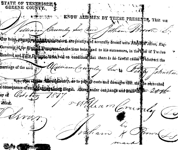
Who Got Married in 1817?

Things get even more confusing in 1817.

Because there is a marriage record for a William Crumley in 1817 in Greene County, it has been assumed (you know about that word) that Lydia, wife of William (the third,) died in 1817 following the birth of Clarissa, and that William (the third) was the William Crumley who married Elizabeth “Betsy” Johnson, believed to be the daughter of Zopher Johnson, Sr., and his unidentified wife, and a cousin to William (the third’s) first wife, Lydia Brown.  By now, I’m positive you’re confused.

However, there is evidence to suggest that William Crumley (the third) was not the William who married Betsey Johnson.

For example, William (the third) and Lydia are reported to have had a daughter, Clarissa, born in April of 1817.  My ancestor, Phebe Crumley was born to William (the third) and his wife, whoever she was, on March 24, 1818, in Lee County, VA as reportedly by later census records, eleven months after Clarissa’s birth, according to Phebe’s tombstone.  Needless to say, if William (the third) married Betsey Johnson in October of 1817, he had a newborn child from Lydia (who would have been being nursed by someone) and had gotten Betsey pregnant about 3 months before their marriage and no more than 3 months after Lydia’s death (if she died).  Yes, that is certainly possible.  But did it happen?

The 1817 marriage bond clearly says that William Crumley Sr., married Betsey Johnson, and William Crumley Sr. was William (the second), the father of William  (the third) who would have been styled as William Jr. at that time in Greene County and clearly was styled as such on other documents from the same time period.

William Crumley Betsey Johnston marriage

It’s no help at all that Jotham Brown signed for both bonds.  Jotham was the father of Lydia Brown, the first wife of William Crumley (the third).  Lydia’s father died in 1799, so the Jotham who signed with an X was Lydia’s brother.

Keep in mind that Betsey Johnson was said to be the cousin of Lydia Brown.  If they were cousins, meaning first cousins, they would have shared grandparents.  Unfortunately, we don’t know who Lydia’s grandparents were, on either side.

If they are cousins, and if Jotham Brown’s wife is Phebe Johnson, daughter of Zopher Johnson, as theorized, but not proven, then indeed Betsey Johnson could have been a cousin of Lydia Brown, but, and this is a really important but – they could not have shared the same mitochondrial DNA.

Mitochondrial DNA is passed from a mother to both genders of her children, but only the female children pass it on.  Everyone carries their mother’s mitochondrial DNA and it is not mixed with any DNA of the father.

If Zopher Johnson had daughter Phebe that married Jotham Brown, Zopher’s unknown wife would have given her mitochondrial DNA to Phebe and then to Lydia Brown, Jotham and Phebe’s daughter.

Betsey Johnson would have been born to a male child of Zopher Johnson by his unknown wife.  Betsey would have inherited the DNA of that male child’s unknown wife, NOT of Zopher Johnson’s wife.  So, unless Zopher Johnson’s wife and his son’s wife shared a common matrilineal ancestor, the DNA of Lydia Brown could not match that of Betsey Johnson.  This is important because the DNA of both Clarissa, born in 1817, before William’s marriage to Betsey Johnson, and Phebe born in 1818 after William’s marriage to Betsey, is a match.  Furthermore, both women also match to another descendant of Phebe, Jotham Brown’s wife.

Zopher wife mtdna path

So, it’s very unlikely that Betsey Johnson is the mother of Phebe Crumley, which eliminates William Crumley (the third) as the William who married Betsey Johnson in October, 1817 in Greene County, TN.

Because I simply could not let this go, I asked Stevie Hughes, a Brown/Johnson researcher, to review the possibilities for Betsy Johnson’s identity and here is what she said, in probability order.

#1 Betsey is the daughter of Zopher Johnson, Revolutionary War Soldier.  I believe this is probable, given he is the ONLY one in Greene County by 1809.

#2 Betsey is the daughter of Moses Johnson, BROTHER to Zopher, the Rev War Soldier.  I THINK….but cannot prove Moses went to adjacent Hawkins Co BEFORE 1809.  I KNOW Moses was gone from Greene Co as of 1809.  He never appears in ANY Greene Co tax list or court record after 1809.  It is POSSIBLE he left Greene County as early as 1800 since there are no tax lists for the north part of the county between 1800 thru 1804 and 1806 thru 1808.  He is NOT in the 1805 list, however, neither is Zopher; so obviously the 1805 list is incomplete or for some reason Zopher (and Moses??) were “missed.”  NOTE the half brother, Harrison Johnson (son of Zopher “the elder” and a much younger, 2nd wife) IS in the 1805 list.  And, in 1809, there is a one-line entry in a Court record stating Harrison is executor of Zopher Johnson “deceased.”  I believe 1809 is the “magic” year where after the death of Zopher “the Elder,” the brothers wanted to go “seperate ways” and the family farm was split among the heirs, with Harrison and his mother going to western TN, Moses goes into Hawkins Co, and Zopher the Revolutionary War soldier is the only one who stayed in Greene Co.

#3 It is POSSIBLE, but very unlikely Betsey was a WIDOW of one of the Johnsons.  Reason being is I have “accounted for” all of our Johnsons in the tax lists from 1790 (arrival) thru 1798 (last complete tax list) until the tax lists resume in 1809 thru 1817.  Also, I have studied ALL Johnson marriages (brides and grooms) from inception of the marriage records up through 1868 (Burgner’s book).  I have an extensive “chart” of all these Johnson marriages, both male and female; and to a large degree, I have cross-indexed those acting for bondsmen (marriages, wills, deeds, etc.)  There are no other Johnsons –male or female– of our family who are in the northern part of the county during these years.  Also, there is no Orphan Court Record (if she was a widow and had children); nor does she appear in a tax list (if she was a widow and her husband’s land went to her).  There is no remarriage for her where one of our greatly intermarried “kin”….or neighbor….acted as the bondsman.  EXTREMELY unusual for our group….. and in my mind it would not have happened for an “outsider” to have been the bondsman for a 2nd marriage.

However, there is one possible fly in this ointment.  Zopher Johnson, the Elder, was born in the early 1700s. It’s very unlikely that he was still having children in 1770-1780 which is when Elizabeth “Betsy” Johnson would have been born, by a first wife.  However, if by some fluke Elizabeth is the daughter of the same mother who had Phebe born about 1745 who married Jotham Brown, then their mtDNA would have been the same.  Jotham the Elder has children from about 1745 to about 1780, so Elizabeth could have been his daughter, but not likely by the same woman as Phebe born in 1745.  Plus, family history says they are cousins, not sisters.

I have to tell you, all of this uncertainly and what-iffing makes my head hurt.  I’m reminded of this cartoon, found on the internet from Pardon My Planet.

Signature Composites

Stevie, sent me this signature composite from various documents in an effort to sort through the various William Crumleys.

Crumley signature comparison

The signature of William in 1817 is showing signs of being unsteady.  The loop on the W wobbles.  William (the third) would have been about 28 and his father, William (the second) would have been roughly 50 at that time.  That’s really not terribly old.  Maybe someone bumped his arm.

To add to the signature confusion, we also have this 1825 receipt from the court in Hawkins County.  We don’t know which William Crumly this is, the second or the third, but it is his signature.

William Crumley 1825 signature

Do you think you have this figured out?  If you’re like me, you think that the 1807 and 1817 signatures are the same, the two 1814 signatures are the same, and the others are different – although how to account for that difference without any more William Crumleys mystifies me.  But just as you get your mind all comfortable with that, I want to share one more signature with you.

William Crumley Civil War signature

Which signature do you think this looks like?  If you said either the 1807 or the 1817 signatures, you would be wrong.  Below is the full document.

William Crumley civil war document

This document is from the Civil War from the National Archives in a document series titled “Confederate Papers Relating to Citizens or Business Firms, 1861-1865,” after BOTH William Crumley (the second) and (the third) were long dead.

This William Crumley could be William (the fourth) son of William (the third,) as he was born in about 1811. Signatures can be both confusing and deceiving.  I jumped like I had been shot when I saw that curly W signature signature (pardon the pun.)

The most reasonable explanation I can find, with the least amount of stretch, is that if William Jr. – meaning the third, was born in 1788 or 1789 as the 1850 and 1852 censuses indicate, he would have been underage when he married in 1807, only 18 or possibly 19 years of age.  His father, William (the second) would have had to have signed for him, which is why the 1807 and the 1817 signatures look alike.  The 1807 William Crumley signature itself doesn’t say Jr. or Sr.  The document only says that William Jr. is getting married.  In 1811, the first year William Jr. (the third) is shown on the Greene County tax list, he would have been age 22,, born in 1789 – so this is very likely the answer.  Otherwise, where was he on earlier tax lists?

Someone Died

Regardless of whether William Crumley (the second) or William (the third) remarried in 1817, someone died.  William (the third) likely lost his mother.  If it wasn’t his mother, then he lost his wife, leaving him with a newborn infant.  I believe it was William (the third’s) mother that died, in part because of the matching mitochondrial DNA evidence between descendants of Clarissa Crumley, Phebe Crumley and Phebe Brown, their grandmother.

If the family was still attending Wesley’s Chapel, William’s wife might have been buried there, although the cemetery appears to date from the “new” church built after the church burned in 1880.  William’s wife might also have been buried at the Cross Anchor Cemetery although at that time it was likely still the Gass Family Cemetery.  Another possibility is that William’s wife is buried in the Kidwell Cemetery which was begun about 1800 when the Kidwell Meeting House stood on that land.  She could also be buried at Carter Station.  A great-grandson, Thomas Crumley, born in 1852, in a letter said that the early generations of Crumley’s were buried at Carter Station.  William (the second) was the first generation to settle in Greene County, so his wife would have been the first of the founding generation to pass over.  The other information provided by Thomas in his letter has proven to be accurate.

The Move to Lee County

Then, in 1819, for some reason, nearly the entire family decided to up and move to Lee County, VA.

Greene co to Lee co

William Crumley (the second) along with two of his sons, William (the third) and Isaac set about in 1819 making preparations for moving to Lee County, VA on the border with Hawkins County, TN.

On April 5, 1819, just before moving to Lee Co., VA., William sold his 126 acres of Lick Creek land to Humphrey Malone.

“The Early Settlers of Lee Co., VA” says that a William Crumley Sr. from Greene Co. bought 250 acres of land from William Sparks on November 11, 1819 for $250.  It was witnessed by William Crumley Jr.  The William Sr. in this case must be William (the second) and Jr. must be his son William (the third.)  Therefore, we now know that William the second did in fact move to Lee Co. along with William (the third.)  However, he is entirely missing from the 1820 census.  Where the heck was he???

TRANSCRIPTION OF CONVEYANCE – SPARKS (to) CRUMLEY

11 NOVEMBER 1819 – 100 acres – DBK 9, p 6, Lee County, Virginia]

This Indenture made this 11th November 1819, between William Sparks of Lee County and state of Virginia of the one part, and William Crumley of the County of Green and state of Tennessee of the other part; Witnesseth that for and in consideration of the sum of two hundred and 30 dollars lawful money of the state aforesaid to him in hand paid by  The sd  Crumley at or before the sealing and delivery of these present the recipt whereof is hereby acknowledged and ……therewith fully satisfied and paid ….bargained sold and deliveres with the said Crumly a certain parsel or tract of land, lying and being in the County of Lee situated on the west fork of black water creek and bounded as followeth to wit:  Beginning at a Poplar and two Beeche’s thence North 35 degrees West 50 poles to a Poplar and Burch on the side of Powell Mountain  Thence with the lines of the original patent so as to include one hundred acres by running straight along 1st survey having the last and to sd William Crumly senior together with its appertenances.  To Have and To Hold The sd delivered parsal of land with all and singular the appertenances belonging as in any anywise to sd premises free from the claim or claims him the sd Sparks or his heirs or assigns forever In Witness whereof  I have herewith set my hand and seal

Sealed, signed, dated and delivered in the presents of}          William x Sparks    {Seal}

Joseph Baker,  mark
William Crumly Junr
Thomas Anderson

Note that the Anderson Cemetery is just a mile or so north of the Lee County line on Blackwater Road and this deed is witnessed by Thomas Anderson.

By 1820, William Crumley (the third) was living in Lee County, Virginia with one male under age 10 (Jotham), 1 male age 10-16 (William or John), one male 26-46 (himself), 3 females under 10 (Clarissa, Phebe and Sarah), one female 16-26 (unknown) and one female 26-45 (presumably his wife.) It’s problematic that one male is missing and one female, Belinda, supposed to have been born in April 1820 is missing as well.

This census raises troubling questions.  Who is the unidentified female?  Only two sons are listed, one son believed to be William (the fourth) is missing.  He is not found in any public record until his 1840 marriage to Rebecca Malone in Greene Co. whereas son John married in 1828 and is found in Hawkins Co. in 1836 and in the 1840 Claiborne Co. census beside William (the third).  Jotham married in 1834 and is found in the 1840 Lee Co. census.  Is William (the fourth) really the son of William (the third) and if so, who raised him and why is he never found in Lee, Hawkins or Claiborne County?

The youngest daughter, Belinda, may actually not have been born until after the census.  Her absence is easier to explain, at least hypothetically.

William Crumley Sr. (the second) who bought the Lee County land is back in Greene County finishing up a lawsuit in October of 1821 and selling his land, preparing to remove entirely from Greene County.  Actually, we don’t know positively that the lawsuit is William Crumley (the second) and not (the third,) as the document never says.  William (whichever) petitions the court to transfer the venue for an appeal of the lawsuit to Hawkins County stating that he doesn’t feel he can get a fair trial in Green County, and that some people, obviously meant to imply the defendant, Johnson Frazier, were “fomenting” hard feelings towards William. He was obviously very troubled by this turn of events.

We’ll never know the details, but it’s certainly possible that William (the second) never meant to remove when he bought the Lee County land in 1819.  He could have been purchasing that for his son, William (the third,) whose wife’s sisters already lived there, but then decided to sell out and move on during the 1821 trial.  Regardless of why, that is exactly what he did.

In 1824, William Crumley obtained a 50 acre land grant on Blackwater Creek in Hawkins County.  This part would become Hancock County in 1845.  We are not sure which of the Williams owned this land, but I suspect it was William (the second.)

In 1834, in Lee County VA Deed Book 15 page 162, a deed from William Crumly  to Peter Louisey (sic) is registered on December 22, 1834 but dated October 31, 1831. William Crumley of Lee County. VA and Peter Livesay of Hawkins County TN, for $300, land in Hawkins County on Blackwater bounded by the Reis (probably Rice or Rheas) line, 47 acres signed W M Crumley.

We believe this 1834 land sale was by William Crumley (the second) since William (the third) had moved to Pulaski County by 1830.  But, we’re not positive since we don’t actually know which William applied for the land grant for this tract of land.

Crumley 1824 land grant

Blackwater Creek

Blackwater Creek is extremely remote, so remote that just getting there requires one to navigate a quagmire of maze like back roads, any one of which could lead to an unexpected problem.  It’s still dirt and one lane and feels more like someone’s long driveway than a road.  Cell phones nor satellite navigation systems work there due to the tall, steep mountains.

Today, bootleggers or under-the-radar farmers who don’t know you and certainly don’t want their crop discovered can be lurking on these desolate back roads.  The locals warn you about this and I was more than a little nervous.  In earlier times, Indian attacks and buffalo stampedes were the worry of the day.  Yes, there were buffalo on Blackwater Creek at one time.  And Indians too.

Blackwater road lee co border

In fact, Blackwater Creek, it turns out, was very desirable property and a very busy place at one time.  Believe it or not.  You’d never know today.

Reading the actual deeds is just so critically important.  In this deed, Isaac Crumley, son of William Crumley (the second) sells land to Polly Stapleton, the sister of Lydia Brown Crumley, the wife of his brother, William Crumley (the third.)

Lee County, VA, Deed Book 7, page 241 – January 15, 1837

Isaac Crumley to Polly Stapleton, 100 acres lying on the west fork of Blackwater, just above Blackwater Salt Works, for $50, adjoining land of John Williams.

Notice the comment about the Blackwater Salt Works.  In this next deed, the salt works aren’t mentioned, but the land granted to John Neill and William Roberts is.

Lee County, VA, Deed Book 12, page 77 – April 25, 1852

Isaac Crumley and his wife Mary of Lee County to William Chandler, Jeff Chandler and William Howe, all of Lee Co, 3 tracts of land on Blackwater Creek, 150 acres, 50 acres granted to James Fletcher, 837 acres, balance of 937 acre tract survey granted to John B. Neill and William Roberts by the commonwealth of Virginia, for $1000.  Signed by both Isaac and Mary B. Crumley

1832 Rhea map salt works

This 1832 Matthew Rhea Map, the first Tennessee map taken from surveys clearly shows the salt works.  In 1832, this is one of the few features noted, so it was obviously well known and important.  And guess who owned this land…

The Sullivan County, TN Department of Archives and Tourism tells us the following:

Blackwater is located at the crossroads of the old trading route from the Cumberland River to the Cherokee nation in East Tennessee and the old hunters trace from the New River to Kentucky. Today, Blackwater is an isolated community as to commerce and transportation, but it was not so isolated in the mid eighteenth century due to the large buffalo lick. Over the eons of time, herds of buffalo had carved out trails radiating out from the lick to the grazing meadows in Powell Valley, Rye Cove, and south to the Clinch River valley. Herd animals would travel great distances to a salt lick to replenish their need for salt, an essential mineral in their diet. A salt lick is a site where the soil and rocks contain a natural deposit of salt and was called a lick because the animals would lick the soil or rocks to a depth of several feet to satisfy their need for this essential element.

A salt lick was the favorite hunting site of the Indians and long hunters. The hunters would position themselves at strategic points along the trails the animals traveled to the lick and make their kill. Numerous historical records of the frontier give accounts of the well-known licks such as the Bledsoe lick in Sumner County Tennessee, the Blue lick in central Kentucky and the French lick in southern Indiana, but little is known about the large lick at Blackwater. Perhaps this is because the Blackwater lick was discovered at least a quarter of a century before the licks in Sumner County in Tennessee, Kentucky, and Indiana and by the time of their discovery the pressure of hunting at the Blackwater lick had depleted the size of the herd animals to near extinction; however, the trails carved out by buffalo remained and were used by the hunters as the choice route leading from the frontier to Kentucky. The long hunters knew about the lick as early as 1761, and it was a landmark on the old hunters path from the New River to Powell Valley.

Land records tell us much about the route the hunters took to seek game around the large salt lick and the grazing grounds in Lee County. The Hunters path is well defined until it reaches the little salt lick, Duffield, but from this point little is known about the route to Powell Valley; however, the land surveyors made notations on their surveys that give clues as to the route of the path. A land grant to Arthur Campbell [LO 45-325] describes the location of the grant as being at the Hunters Gap in Lee County and on both sides of the Hunters path. This tells us that the Hunters path ran along the south side of Powell Mountain from Duffield to Blackwater and crossed the mountain at Hunters Gap. The path ran down Wallen creek to near its mouth on Powell river where again the land surveys pick up the route of the Hunters path.

Another grant to Arthur Campbell [LO Q-318] is described as being on the south side of the Powell River and on both sides of the Hunters path. This grant is located about one mile west southwest of where Wallen Creek flows into Powell river. The Campbell grant [LO Q-318] is adjoined on the west side by a land grant to Robert Preston [LO 27-57]. The Preston grant is described as lying on both sides of the Hunters path. From this information, we know that the Hunters path ran from near the mouth of Wallen Creek across the area known as the Rob bottoms and crossed the Powell River at White shoals. Again, the surveys tell us that the path ran in a north or northwest direction from White shoals as a grant to Robert Preston [LO 27-41]is described as lying on the west side of trading creek and one of the survey points is described as “white oak south side of the old Kentucky trace on John Ewing line with same”. From this point, the path or trace ran to Martins station but the exact route cannot be proven by land records.

Records show that Elisha Wallin and William Newman hunted around the Blackwater buffalo lick as early as 1761. Wallins Ridge and Newman Ridge were named after them.  (Note that Wallin’s Ridge and Newman’s Ridge border Blackwater Creek on either side.) Other long hunters surely knew about the lick. Evidence of the buffalo trails remains on modern maps by the names of geographic features such as Hunters Ford, Hunters Valley, Hunters Gap and Hunters Branch. No doubt the long hunters in quest of game followed the herd animal paths from their favorite grazing grounds to the salt licks. There were many small licks in the area used by deer and other small game, but needs of the herd animals would require the mineral deposits of a much larger lick such as the Buffalo Lick at Blackwater.

The importance of the Blackwater lick is clearly pointed out by the claims of the land speculators. As early as 1775, Thomas Osburn had settled on land adjoining the Buffalo lick and obtained a land grant from the Commonwealth of Virginia by virtue of Right of Settlement.

“Washington County Survey Book 1,Page 389 Commissioners Certificate – on the forks of black water a north branch of Clynch River – beginning at the foot of Powells Mountain on the west side of the Buffalow Lick – at the foot of Newman’s ridge on both sides black water joining Powells Mountain, includes improvements, actual settlement made in 1775 – August 22, 1781”.

The name Blackwater appears in land claims as early as 1775, and the name was known far and wide. Claims were filed in the Virginia Land Office and the North Carolina Land Office for land at Blackwater so hunters from North Carolina and Virginia had spread the word about the large buffalo lick at the Blackwater.

From the North Carolina Archives, we find that Walter and Robert King filed an entry with the North Carolina Land Office for 250 acres that was to include an old buffalo lick.

“Recorded in North Carolina Land Office File No 28 Hawkins County records. Walter King & Robert King make entry No 1947 entered 12 Oct 1779,250 acres near the foot of Powell mountain by the name of Black Water: Beginning near the creek at a poplar, white oak, poplar s;150 poles to a stake, then W;280 poles to a stake, then n;150 poles to a   stake, to include an old Buffalo Lick, surveyed 16 Sep 1793. Thomas Church assigned his interest in the Wilkins land to William Hord and Hord assigned it to Walter King & Robert King 1 Nov 1792”.

In the meantime, Walter Preston was issued a land grant from Virginia that bordered the Thomas Osborne grant and included the buffalo lick. To further complicate the issue Arthur Campbell also obtained a grant from Virginia that included the buffalo lick, all of the Thomas Osborne grant and much of the Preston grant. Apparently Preston ended up as the legitimate owner as he sold his grant to James White. The heirs of Campbell made an effort to reclaim their Blackwater grant, but I find no record that they were successful.

Blackwater buffalo lick

Osborn and Preston land grants at Blackwater, Virginia. Copyright 2009, W. Dale Carter.

The Thomas Osborn grant ended up under the ownership of James and Stephen Osborn. A deed recorded in Lee County Deed Book 3, page 189:

“Stephen Osborn & Comfort & James Osborn & Mary to William Roberts, 31 Jul 1810, DB 3-189. 400A by survey only the 1/2 of the Buffalo lick excepted for James Osborn the same being the west side of the said lick running through the middle thereof with the conditional line made by John Osborn & Roberts from thence marked around the lick on or near the bank of the same $650”.

This deed shows that James Osborn reserved for himself ½ interest in the salt lick when the Thomas Osborn grant was sold to William Roberts. Apparently the lick site was developed as a salt works as a deed made 29 December 1817 and recorded in Lee County Deed Book 3, page 399, shows that William Roberts and his wife, Catherine sold ¼ part of a tract known as the Blackwater tract, to Jessee G. Rainey.

“Being a part of tract said Roberts purchased of James & Stephen Osburn. Including the lick premises and well, now occupied by said parties together and including 100 acres”.

The deed shows that by the year 1817 a well had been dug at the salt lick site. On 5 June 1818 William Roberts and wife sold 1/8  part including the lick premises and well recorded in Lee County Deed Book 3, page 405, and on 12 May 1818 William Roberts and wife sold ½ interest of the lick tract to Joseph and James McReynolds of Bledsoe County, Tennessee for $3,000. Recorded in Lee County Deed Book 3, page 406. The McReynolds deed shows that something of great potential lay within the boundary of the tract. At that point in time, land in and around Blackwater was selling for $1 to $2.50 per acre. The McReynolds paid $60 per acre.

From this time forward, the land records do not show what happened as to the ownership of the salt lick tract; however, on 19 January 1835, by order of the Lee County court, Jacob V Fulkerson, commissioner of the court, sold one moity of the Blackwater salt lick to Dale Carter of Russell County, Virginia. Carter was a large land owner and land speculator who owned large tracts in the Elk Garden and in present-day Wise County, Virginia.

Why all the interest in the buffalo lick? Most likely these early land speculators had visions of developing the site as a salt works much like the one at Saltville. In fact, a salt works was operated at Blackwater for a period of time.

There are two further pieces of information that have a bearing on the land and the road where William Crumley (the second) and probably (the third) lived.

Lee County Order Book 2, page 364 27 Jan 1818; David Burk proposes an alteration in the road leading from the Blackwater salt works up Blackwater to the state line.

The above statement shows that “up” does not mean north, because the state line is south of the salt lick.  Therefore, the land description that says that the Crumley land was “above” the Salt Lick probably means between the lick and the state line.

Lee County Order Book 2, page 374, 29 Apr 1818: John B Neil, Elisha Rogers; Thomas Roberts; William Wallin and David Lawson view a road from the forks below the Blackwater salt works to John B Neils.

This would be the road where William Crumley lived.  His land abutted that of John Neils and William Roberts .

Today, the Roberts Cemetery is near the head of Blackwater Creek in VA, very near the salt lick, located on SR 70, 10 miles south of Jonesville, VA at the foot of Powell Mountain near a group of houses across the road from the Collingsworth Cemetery.  The Roberts Cemetery is where Polly Stapleton, aka, Mary Brown Stapleton, sister of Lydia Brown, wife of William Crumley (the third) is buried.  In fact, it may also be where Lydia Brown Crumley is buried as well.

Note also that William Crumley (the third’s) grandson, John Crumley’s son, James H. Crumley born in 1839 in what became Hancock Co, married on May 10, 1865 to Martha Anderson.

Anderson Cemetery Roberts Cemetery

On this map above, the Anderson Cemetery (left red arrow) is about a mile north of the Virginia/Tennessee border, and the salt lick is another 2-3 miles north of that.  The Roberts Cemetery (right red arrow) is near the salt lick.

You could say that all of Blackwater Road was the Crumley stomping ground.  They knew every nook, cranny and mountain ridge.  William Crumley the second lived his life from 1820 or so until his death after 1837 but before 1840 and his son, William Crumley (the third) lived here from 1820 or so until he packed up his wagon and left for Pulaski County before 1830.  In 1840 William Crumley (the third) had moved back and lived nearby, one ridge over, but by 1850, he was once again living on Blackwater, on the Tennessee side of the line.  For thirty years William Crumley (the third) trod and plowed this land and the land in this area…more or less…except when he moved to Kentucky.  William (the third) buried his wife, (step)mother and father here, not to mention his son Jotham…and those are only the family members we know about.  There were surely more.

I have to believe he would have been pleased to see me on Blackwater Road, looking for his land.  Seems that the Crumleys return here much as the buffalo returned to the salt lick.

Which William Lived Where?

The 1830 census becomes even more confusing, because William (the second) has apparently moved to Pulaski Co., KY., 80-100 miles west of Lee Co., Va. where he appears on the 1830 census age 40-50, one female 20-30 (unknown), one son 5-10 (Aaron), one son 15-20 (Jotham), one daughter 5-10 (Belinda), one daughter 10-15 (Phebe), one daughter 15-20 (Sarah or Clarissa) and one female 40-50, presumably his wife.

Again, son William (the fourth) and a daughter are missing, although Belinda, or at least a female that age, is present in this census.  There is also an extra female, age 20-30.

Pulaski County records have never been searched for William although many of their records were destroyed by fire in 1871.  William could have lived there for only a short time, around 1830, or he could have lived there nearly 20 years, from not long after 1820 to not long before 1840.  A volunteer searched the tax records from 1823-1839 and found no William Crumley, although three years were missing.  I’m guessing this means that he likely did not own land there.  I searched Pulaski County grantor indexes and found no William Crumley by any similar spelling, including Chumley.  The grantee indexes have not yet been imaged, but to buy and sell you have to be both a grantee and a grantor, so it’s unlikely that William owned land in Pulaski County.

Unfortunately, this was my last hope for discovering, positively, William (the third’s) wife’s name after the 1817 marriage.

However, in 1830, there is a William Crumley living in Lee County.  Lo and behold, it appears to be William Crumley (the second).  He is shown, aged 60-70, which would be accurate.  He was shown with 2 females in the household, his wife age 50-60 (presumably Betsey) and a girl age 5-10, possibly a grandchild, or maybe he and Betsy Johnson had one child after their marriage.

Sometime during the next decade William (the third) returned from Kentucky.  I think he returned before 1838 because his daughter Melinda (Malinda, Belinda) was married to James Hervey Davis in Claiborne County in 1838 – and you have to see each other to court.  He may have returned before August 1834 when his son Jotham was married in Lee County.

William (the third) appears on the 1840 Claiborne Co., TN census, age 50-60, possibly no wife, one son 15-20 (Aaron,) two daughters 20-30, (Sarah and Phebe) and one female 60-70 who is unknown.  The female age 60-70 could Lydia and the census date column information could be wrong.  Or Lydia could have died and the female could be Betsy Johnson Crumley, since it appears that William (the second) had died.

Wouldn’t it be a great twist of irony if William Crumley (the third) actually did wind up living in the same household with Betsey Johnson Crumley after his father’s death, even though he was not her husband, but her step-son, as well as her cousin by marriage.  Sometimes, the truth is stranger than fiction.  Especially in this family line.

Finding William (the Third)

The Claiborne County residence in the 1840 census also suggests that William Crumley is living further west than his father who lived on the border of VA and TN on Blackwater Road, which was part of Hawkins County before Hancock was formed about 1845.  Blackwater Creek and Powell Mountain were originally the eastern boundaries of Claiborne County, where it intersected with Hawkins before the formation of Hancock.

Interestingly enough, I accidently discovered where William was living in 1840 – and it makes a great deal of sense.  This comes in the “truth is stranger than fiction category,” as I wasn’t looking for William Crumley at all when I made this discovery.

I had noticed that in 1840, William Crumley (the third) was listed on the census, along with his son John Crumley, living between Eli Davis and Littleton Brooks.

William Crumley 1840 Claiborne

I was looking for where Elizabeth Shepherd McNiel lived in 1830, and she lived beside her son Niel McNiel.  I noticed in some documents that Niel’s land abutted that of Josiah Ramsey.  One of my very experienced genealogy cousins descends from the Ramsey family and I knew she had done a lot of research, so I contacted her to see if she knew the location of Josiah Ramsey’s land.

Cousin Dolores sent a map with land locations overlaid, which was of primary importance.

Josiah Ramsey land division

On the 1830 census, Elizabeth McNiel and her son Niel McNiel live between Josiah Ramsey and Eli Davis in the upper right hand corner of this map.

In 1840, William Crumley is living between Eli Davis and Littleton Brooks and near the Hopkins, all shown on this map as neighbors.

In the lower left, Daniel Rice’s land is shown where it would abut Elijah and Joel Vannoy’s lands.  Why is this important?  Because in 1845, William Crumley (the third’s) daughter, Phebe, would marry Joel Vannoy, son of Elijah Vannoy.

So, not only do we now know how Phebe and Joel met, as near neighbors, we also know where William Crumley was living in 1840 after he returned from Pulaski County, KY.  Additionally, in 1848, William’s daughter Sarah would marry Edward Walker, who lived a mile or so beyond Elijah Vannoy’s land on Mulberry Gap Road.

Now, where is this land today?  On the map below, William Crumley likely lived just below the Turner Hollow label.

McNiel to Vannoy

I mapped the location where Niel McNiel would have been living next to Elizabeth McNiel and Eli Davis on present day Turner Hollow Road (on the right) and then where Joel and Elijah Vannoy owned land on Mulberry Gap Road at the red balloon on the left.  Keep in mind that they would likely have taken the “back way” since Rebel Hollow and Turner Hollow intersect and it looks like Joel and Elijah Vannoy probably owned the land between Mulberry Gap Road and the back side of Rebel Hollow Road.  Of course, at the time, it wasn’t called Rebel Hollow Road – a name it acquired during the Civil War.  The history of the Mulberry Gap church tells us that the name arose because a group of southern sympathizers lived there.  Hmmm….

William (the Second) Dies

In January 1837, William (the second) sold his land in Lee County to his son Isaac.  In 1841, Isaac had to prove the deed in court by the testimony of James Weston, Thomas Stapleton and Thomas Weston (husband of Hannah Crumley), the same men who witnessed the 1837 sale, and the deed was recorded October 18, 1841.  This, along with the fact that William (the second) is missing in the 1840 census, suggests that he died between 1837 and 1840.

Thomas Stapleton is the son of the sister of Lydia Brown, Mary “Polly” Stapleton.  In fact in an every larger twist of fate, Isaac, just a decade later, sells at least part of the William Crumley land on Blackwater to Polly Stapleton.

William (the third) lost his father about 1840.  This could have had something to do with why William (the third) returned to the area from Pulaski County.  His father may have been ill in the 1830s and needed help.

William Goes A-Courtin’

William (the third’s) children began marrying in 1828, when John, the eldest son, married a woman named Mahala, last name unknown.  In 1834, Jotham married Anne Robinette in Lee County.  Clarissa married John Graham in 1834 in Greene County and Melinda (or Belinda) married James Hurvey Davis in Claiborne County in 1838.  Aaron wouldn’t marry Anne Scofield until 1844 and Phebe married Joel Vannoy in 1845.  In 1848, Sarah, called Sallie, would marry Edward Walker, a widower who lived in Mulberry Gap Road just down from where Phebe and Joel Vannoy lived.  By 1848, William’s cabin would have been empty and quiet, so it appears that William went a-courtin’.

William (the third) married Pequa (Pya, Pqa, Paa) some time in 1849 or early 1850.  They are listed in the 1850 census of Hancock Co. as ages 61 and 53 and it’s noted that they were married within the past year.  Unfortunately, the Hancock County courthouse burned, twice, so there is no further information available.

It’s unlikely that Pequa had never been married before, given her age.  However, there are no children showing that would have been hers, so if she had children, they were already married and gone, although that is unlikely given that women generally have their last child in their early 40s.

Pequa’s name is extremely interesting.  In 1850, William Crumley (the third) lives in the middle of the Melungeon neighborhood.  John Crumley, his son, lived adjacent and very likely married into the population, as his wife’s name is Mahala, a name traditionally found in the Melungeon families, made particularly famous by legendary Melungeon Mahala Mullins, a very rotund and colorful bootlegger.

The Crumley land, on Blackwater, is also in the Melungeon neighborhood.  The name, Pequa, however, is not found in any other instance in this region to the best of my knowledge, and I’ve researched here for over 30 years now.  Pequa, is, however, a Shawnee word for Phoenix, or risen from the ashes.  There have been family rumors for years of this line being “Native,” but if this is true, and it’s through Pequa, then it’s not a direct line to any of the Crumley children, because by the time Pequa married William Crumley, she would have been too old to have children.

One More Move

Something nudged William to move on, even though he had already seen his 60th birthday.  Why William would want to pack up everything he owned, leave much of his family behind and rattle around in a wagon with no shocks, creaking and bouncing over dirt roads full of wagon ruts, or mudholes, depending on the season, is beyond me.  Appanoose County, Iowa is about 800 miles, on today’s roads, from the area where William lived in Hancock County.  At ten miles a day, the journey would have taken 80 days, or nearly an entire miserable summer.  What was this man’s motivation?

Hancock Co to Appanoose Co

Furthermore, Appanoose County is significantly further north than Hancock County, Tennessee.  I’m betting that William had no idea what was in store for him in terms of winter weather.  Genweb has a delightful page with frightening snow pictures of Iowa weather.  I doubt, if William had seen these, he would have been nearly so willing to depart.  It’s dramatically different than the South.

Appanoose snow

William and Pequa moved to Appanoose Co., Iowa in 1851.  William was shown as age 64 on the 1852 Iowa State census, so born about 1788, but did not appear on the 1860 Appanoose Co. census that listed Pequa as age 64.  William (the third) apparently died after the census in 1852 but before the census in 1860.  He did not die within a year of the census, because he is not listed in the 1860 mortality schedule.  Pequa’s death date is unknown but both are buried someplace in Appanoose Co., Iowa.  After William’s death, Pequa lived with a family in Unionville, a very small town of about 2 blocks in length.  Perhaps William is buried near here.

Unionville, Appanoose Co., Iowa

Iowa was a very different place than William (the third) had ever lived.  It was flat with a horizon that went on forever.  No hills, no mountains.  I wonder if he was happy.  I guess, in part, that answer might have something to do with why he left in the first place.  Perhaps he missed owning land and he apparently had none after returning from Pulaski County, KY.  Maybe he had never really owned land.  Or maybe he just had a case of wanderlust.

Appanoose co horizon

In the “Iowa History up to the 20th Century – History of Iowa from the Earliest Time to the Beginning of the Twentieth Century” Vol 3, in the “Early History of Iowa” section, page 349, Greene Co., it mentions William Crumley coming to Greene County in 1850-51.  This is the same time that the other Crumleys migrated to Iowa.  On the same page in the book, it mentions S.G. Crumley as county clerk and Isaac D. Crumley as sheriff.  The Crumley men apparently succeeded there.

“The History of Appanoose County, Iowa, Containing A History of the County, its Cities, Towns” tells us that land opened for survey in 1850, was initially delayed a bit due to a boundary issue, but by 1860, nearly all of the land was claimed.  The availability of land may have been why William left for Iowa.  Maybe William found something he had chased his entire life.  A review of the Iowa records has never been done.

William’s Death

Several months after I wrote and published this article, cousin Keith, a descendant of William’s son, Aaron, contacted me and said that back in the year 2000, he had visited the Unionville, Iowa cemetery and had found William’s stone.  He took a photo and was kind enough to share with me.

William Crumley stone

I was there able to find the cemetery on Find-A-Grave and found another photo as well.

William crumley stone2

“From the collection of Rhonda L. (Atkinson) Johnson – Find a grave contributor #47027837 rhondabrent Ancestry Family Tree: Atkinson Family Tree:rhondabrent1”

Indeed, this cemetery is just within the village of Unionville, in the upper right hand corner by the T61 marker, to the right.  You can see the rectangle shaped area.

Unionville Iowa map

Here’s a closeup of the cemetery

Unionville Iowa cemetery

William’s final resting place has been identified now, thanks to cousin Keith, and along with it, a mystery has been solved.  The inscription of William’s stone not only tells us when he died, but how old he was, down to the day, so we can now calculate his birthdate as well.

William died on February 15, 1859 at the age of 70 years, 8 months and 13 days.  Utilizing a reverse date calculator, this gives us a birth date for William of June 2, 1788.

Many thanks to cousin Keith.

William’s probate record is shown below as well.  Perhaps eventually the wills of Appanoose County will be online as well.

william-crumley-1859-probate

William’s Children

Children of William (the third) assembled from family information, census and land information are as follows:

  • John Crumley born 1808 in Green Co, TN married Mahala born in 1812 and lived in Hancock County. He named a daughter Lydia. The 1870 census shows a John Crumley in Lee County VA, age 62 (born 1808) with Mahalia, 58, several children, with John stating he was born in Green Co., TN.
  • William Crumley (the fourth) who married Rebecca Malone in 1840 in Greene County was attributed to William (the third,) but I have my doubts, especially since William (the third) was “missing” a child in both census where William (the fourth) should have been listed. However, this William did name a child Jotham.  It also appears that Clarissa was raised by someone in Greene County as well.
  • Jotham (also noted as Sotha) Crumley born October 23, 1813 Greene Co., TN, died August 22, 1841, Lee County, VA, married Ann Robinette on August 14, 1834 in Lee Co., VA.
  • Sarah “Sallie” Crumley born 1814/1815 in Greene County, TN, married Edward Walker in 1848 in Hancock Co., TN. The Walker homestead, a log cabin, still stands.  The Vannoy and Walker households in Hancock County were on the same road and only a mile or so apart.

walker homestead

  • Clarissa Marinda Crumley April 10, 1817 married George Graham in Greene Co January 16, 1834, buried in the Cross Anchor Cemetery, Greene County, TN. There are no children named Lydia or Jotham, but the mitochondrial DNA of Clarissa’s descendants matches that of Phebe, indicating they share a common maternal ancestor.
  • Phebe Crumley born March 4, 1818 died January 17, 1900 married Joel Vannoy and in the late 1860s, moved down the road to Claiborne County where they lived in the Little Sycamore community in Vannoy Holler and had a large family.
  • Belinda Crumley born April 1, 1820 married James Hervey Davis in 1838 in Claiborne County. She died in 1905 and is buried in the Mulberry Gap Baptist Church Cemetery.  Of note, she also named a daughter Lydia.  I would very much like to have a DNA test from someone who descends through all females through one of her 4 daughters, Martha, Lydia, Nancy and Louisa.  This would confirm or refute the tests of Clarissa and Phoebe as being the children of Lydia Brown.
  • Aaron Crumley born in 1821 in Lee County, married Mary Ann Scofield on November 21, 1844 in Claiborne County, TN. Named a son Jotham.  Aaron moved to Iowa with William and Pequa.

Cousin Keith also provided a photo of Mary’s stone, also found in the Unionville, Iowa, Cemetery, so we know that Aaron lived close by as well.

Mary Scofield Crumley stone

She died November 1, 1862 at 38 years, 7 months and 1 day.  I would have expected that Aaron would be buried here as well, in an unmarked grave, but cousin Keith uncovered information in later census that Aaron went on to Missouri and Kansas.

Cousin Keith also provided an obituary for one of Aaron’s sons, which may provide some breadcrumbs for researchers on this line.  I notice that the Crumleys continues to move to new areas as Indiana, Pennsylvania and Houston, TX are mentioned.

Crumley, Aaron's child obit

Of William’s children, the ones I most question as belonging to William Crumley (the third) and his wife, Lydia, are William and Clarissa, both because they married in Greene County, TN.  Either they were raised there, or the family traversed back and forth quite a bit.

Crumley DNA

When I first began the Crumley DNA project, there was one burning question we wanted to answer.

In addition to this Crumley family, who at that time we presumed was connected to the Greene County group, there was one George Crumley in Sullivan County, TN.

For decades, the two families searched for a common ancestor or a link to prove they were related – or that they weren’t.  That link remained elusive, although both families did have children named William,  Unfortunately, William is such a common name that one really can’t draw any inferences from that alone.

The most difficult part of this comparison was finding the first Crumley males from each group to test.  DNA testing was in its infancy.  I formed the Crumley DNA Project and began to see who I could find to test to represent the two lines.

I’ll never forget the cousin, nicknamed Wildman, who made and sold possum skin bikinis for larger women on the internet, and would give a discount if the lady would send him a picture of herself in the bikini.  Wildman wanted to know if I wanted to clone him.

I told him no, and the possums don’t want more than one of him either:)

At that time, more than a decade ago, there was little understanding of any genealogical DNA testing, so the folks who tested did so simply out of trust and good grace.  Wildman represented the Sullivan County line and my cousin Jerry represented the Greene County line.  We just knew we were all from the same ancestral line.

Except… we weren’t.

Thank Heavens, the answer is definitive.  No maybe or ambiguity about it.  Not only are we not related, we’re not even in the same haplogroup.  We were disappointed, but so glad we could stop chasing that elusive connection document that didn’t exist.

The George Crumley line is haplogroup G-M201 and the Greene County line is haplogroup I-M223.

Crumley DNA project

But, are we sure?  Was there an NPE or undocumented adoption in one line or the other.  We needed a second male descended from a second son of each ancestral line to test, just in case.

We found another Crumley male for the Greene County group three months later, but it would be another year before we found another male for the Sullivan County group.  Even today, that group hasn’t grown beyond the original two.

We did in fact confirm that yes, the two groups are entirely separate.  Now the confusion is only genealogical when their descendants move into counties where their records are co-mingled – like, oh, say, multiple William Crumleys.

Yep, the Crumley Curse lives on!

Acknowledgements:

Other contributing researchers to the Crumley family are Truett Crumley (deceased), Paul L. Nichols (deceased), Stevie Hughes, Larry Crumley, Irmal Crumley Haunschild (deceased), Jerry Crumley, and Nella Myers (deceased.)

______________________________________________________________

Disclosure

I receive a small contribution when you click on some of the links to vendors in my articles. This does NOT increase the price you pay but helps me to keep the lights on and this informational blog free for everyone. Please click on the links in the articles or to the vendors below if you are purchasing products or DNA testing.

Thank you so much.

DNA Purchases and Free Transfers

Genealogy Services

Genealogy Research

London DNA Sculpture Trail

I’m typically not a “things” person, but I’m telling you, I want one of these for my garden.  Oh yeah!!!!!  In fact, I think making one would be great fun!!!

helix sculptures

This summer (2015), you can take part in an extraordinary event across London, England, in support of Cancer Research UK.

This London art trail is made up of 21 beautifully designed giant double helix sculptures and runs until Sunday the 6th of September.  These sculptures have been designed by some of the biggest names in art and design. Check out the sculpture map, watch the video of how one sculpture was made, and start planning your trail now, at least if you’re going to be in London.  I surely wish they’d do a virtual tour for those of us who can’t visit in person.

helix sculpture map

At the end of the summer, these sculptures will be auctioned to raise funds to complete the Francis Crick Institute, the scientist of course who discovered DNA.

You can see the Individual sculptures here.

I personally love the Delft one.  And the cat one with the buttons.  And the orange tree from Spain.  And the helix ladder.  And the symbolic swallow with handprints.  Ok, I like them all.  Which one is your favorite?

Update:

Subscriber PB has sent two photos of the sculptures in London.  Thanks PB.  If anyone else sends photos, I’d love to add them too.

DNA Sculpture 1

DNA Sculpture 2

______________________________________________________________

Disclosure

I receive a small contribution when you click on some of the links to vendors in my articles. This does NOT increase the price you pay but helps me to keep the lights on and this informational blog free for everyone. Please click on the links in the articles or to the vendors below if you are purchasing products or DNA testing.

Thank you so much.

DNA Purchases and Free Transfers

Genealogy Services

Genealogy Research

What is a Population Bottleneck?

water being emptied from a blue glass bottleGenetic genealogists often hear the term population bottleneck referenced in various academic papers – but just what is that?  And why do we care?

A population bottleneck occurs when there is a dramatic reduction in the population of a particular group of people.  Think about the eruption of a volcano – Mt. Toba for example.

Human history is full of population reducing examples, some we know about, like the plague, but most we don’t.  And obviously, if the bottleneck was so severe that no one survived – then there are no descendants of those people today – and that’s an extinction event, not a bottleneck.  The only way we would ever know those people existed is if we found their remains and sequenced them today – like the Neanderthal and Denisovan skeletons.

As a point of clarity – the Neanderthal and Denisovan did survive – not as pure Neanderthals or Denisovans – but admixed into the homo sapiens population – and they are indeed, us.  If you have either European or Asian ancestry, then you have Neanderthal and Denisovan ancestry too.

How could that be – all of Europe and Asia descended from these Archaic people?  Probably the after-effects of a population bottleneck where a small group of people went on to become a large group of people.

Let’s look at an example.

The best example I can think of is the migration of the Asian people into the Americas.  These first people would populate all of North and South America and would become the indigenous people of these continents – by whatever name is applied today.  First People, Native Americans, American Indians – they are all of the same stock and the result of at least one population bottleneck.

That first bottleneck occurred when some people crossed over the land bridge, Beringia, between Asia and what is now Alaska.

beringia map

Erika Tamm et al – Tamm E, Kivisild T, Reidla M, Metspalu M, Smith DG, et al. (2007) Beringian Standstill and Spread of Native American Founders. PLoS ONE 2(9): e829. doi:10.1371/journal.pone.0000829. Also available from PubMed Central.

The bottleneck event that occurred there was that there weren’t very many people. It was probably a small group.  Possibly very small.  What do we know about them?

There were obviously males and females.

Assuming for purposes of discussion that all of the people who founded the Native American population came at once, or in what is referred to as one wave, we know that there were at least two men and 5 women.

How do we know that?  Because today we have Y haplogroups Q and C in the Native population and mitochondrial haplogroups A, B, C, D and X in that population as well.  Since the Y chromosome is passed from father to son unadmixed with any DNA from the mother, the haplogroups we see today are directly descended from those original founders.  Mitochondrial DNA is passed from the mother to all of her children, but only the females pass it on, so we get a direct pipeline view back to the founding mothers.

There may have been more individuals and haplogroups that arrived.  Some may have died out in Beringia or afterwards in subsequent bottleneck events.

Let’s say the group stayed together for a while.  Then, it got too big to support itself comfortably on the resources available.  In other words, the population began depleting the available resources.  So, the group separated by a few miles so that they could draw off of a different landscape where food was more abundant.

One group went 20 miles east and one group went 20 miles south.  It wasn’t meant to be permanent, but eventually, the split became permanent as that scenario repeated itself over time.

Eventually, one of the groups moved further south and small groups broke off from time to time and moved east across what would be the US and Canada.  Part of the group continued south along the Pacific and would populate Mexico, Central and South America.

Let’s say that one of those small bands of people that headed east wound up living in Montana, 12,500 years ago.  A child died, and they buried that child.

The group they separated from continued south and their descendants are found throughout Mexico, Central and South American today.

That child’s name is Anzick.  His skeleton was found in 1968 and his full genome was sequenced before he was reburied in 2013.  When his DNA was sequenced, we discovered, much to our amazement, that Anzick indeed matched people, primarily people from south of the US, at a level that could be interpreted to be contemporary.  How could that possibly be?

Think about a bottleneck in this fashion.

There are 4 people, 2 couples.  Each person’s DNA is represented by a color.  The two males are blue and green and the 2 females are pink and yellow, like on the left side of the pedigree chart shown below.

perez autosomal

In the first generation, they pass their DNA to their children and the children are blue/yellow and green/pink.  In the second generation, the children intermarry with the other couple’s children – because there are no choices.  All of the grandchildren of the original couple have DNA that is blue, yellow, green and pink.  The children and grandchildren don’t all carry the same segments of blue, yellow, green and pink – but all of them carry some part of the original 4 founders.  There is no orange or turquoise or red DNA to be found, so forever, until new people enter the landscape, they will pass the same segments of blue, green, yellow and pink DNA to their descendants.  In an isolated environment, they might not meet new humans for thousands of years – lets’ say 10,000 years.

So, if the Anzick child had blue, yellow, green and pink DNA and the contemporary Native people living in South America have blue, yellow, green and pink Native DNA from those same four founding ancestors, it stands to reason that they are going to match – because it’s the exact same DNA that has been passed around and around for thousands of years.

This matching is the effect of a population bottleneck.

We can think of other bottleneck events too.  For example, the Acadians were a bottleneck event.  A few shiploads of French Catholic people on an Island in the early 1600s – they didn’t have a lot of choice in terms of spouses. The genealogy saying is that if you’re related to one Acadian, you’re related to all Acadians, and it’s pretty much true.  Same with the Pilgrims and the individuals who came over on the Mayflower.

Some bottlenecks are religiously induced – Amish, Mennonite and Jewish, for example.  These people marry only within their religion.  Today, that’s called endogamy – but it’s a form of a bottleneck event.

We see the results of bottleneck events today in three ways in our DNA.  In both Y and mitochondrial DNA, we often see specific haplogroups or subgroups associated with specific populations – like Q and C in Native American Y DNA and subsets of A, B, C, D, X and possibly M in Native American mitochondrial DNA.

We also see the effects of bottleneck events in autosomal DNA.  We talk about segments that are IBD, identical by descent, and IBS, identical by state.  Identical by descent typically means we can attribute the DNA segment to a specific ancestor via triangulation.  Often, everything we can’t identify gets tossed into the IBS box, but it really shouldn’t.

When you hear people talk about IBS, or autosomal DNA segments that are identical by state, there are really two possibilities.  One is that the DNA is identical by chance.

The other option is that the DNA is identical by population.  This means that the DNA does indeed match because it came from a common ancestor – but that ancestor is beyond the genealogical timeframe.  That doesn’t mean the information isn’t useful.  Indeed, I think it’s very useful.  I want to know if a segment of my DNA is Native, even if I share that segment with lots of other Native people.  In fact, that’s exactly HOW we determine a specific autosomal segment is affiliated with Native or any other population group of people.  Certain segments are found in a higher percentage across the entire population group.  So, to throw these out in personal genetic genealogy by phasing which removes population based matches is a case of throwing the baby out with the bathwater.  I have several matches on my spreadsheet where I have the notation “Mennonite” or “Acadian” for example, because while I can’t sort out which specific ancestor the DNA came from, it assuredly came from the Acadian population based on the matches – and that’s very useful information.

Population bottlenecks may seem like a scientific term referencing something that happened long ago, but the effects of bottlenecks can be found in every one of us, beginning with Neanderthal and Denisovan DNA and probably including ancestors who survived, or willingly embraced beliefs which in essence created historical bottlenecks.

______________________________________________________________

Disclosure

I receive a small contribution when you click on some of the links to vendors in my articles. This does NOT increase the price you pay but helps me to keep the lights on and this informational blog free for everyone. Please click on the links in the articles or to the vendors below if you are purchasing products or DNA testing.

Thank you so much.

DNA Purchases and Free Transfers

Genealogy Services

Genealogy Research

Zeroes aka Deletions – Null DNA Markers

Someone recently asked me about why one of their Y DNA STR marker values was zero, what that means, and how it got to be that way.

Probably the marker most prone to develop this trait is marker 425, the 48th marker that is in the 67 marker panel.  If you haven’t tested beyond 37 markers, then you won’t see a result for marker 425, because it’s in the 67 marker panel which tests markers 38-67.

A null marker result looks like this for Y DNA:

null result

You can see that location DYS425, highlighted in blue, has a zero and a red asterisk.

This means that there is no DNA present at that location, and a deletion has occurred.

Mitochondrial DNA

Deletions also occur in mitochondrial DNA.

If you view your results as CRS values, deletions show as little dash marks.

Mito deletion CRS

In the RSRS results view, below, they are shown with a little d indicating a deletion has replaced the normal value shown before the location number.

Mito deletion RSRS

In the case above in the coding region, an entire contiguous segment has been deleted.  In mitochondrial DNA, these are sometimes haplogroup defining.

While deletions also occur routinely in mitochondrial DNA, we’re going to use Y DNA for our discussion and examples.

What Does This Mean?

A zero in Y DNA as a marker result means that no DNA was detected at this location.  In essence, barring a lab processing error, it means that the DNA that used to be in this location got deleted in the process of replication at some point in time.

Once DNA on the Y chromosome or mitochondrial DNA is gone, it’s gone forever.  This is called a deletion.

Why Did This Happen?

We don’t know exactly why deletions happen, but they do.  If the deletion is in an area that isn’t troublesome to the organism, life goes on normally and the deletion is passed on to the next generation.  If the deletion would interfere with a critical function, typically the organism is never born.

So, if you have a deletion, it’s really nothing to worry about, because, chances are your ancestors, for generations, had this same deletion and you are obviously here. 

When Did This Happen?

Sometimes we can deduce an answer to this question, at least somewhat.

If your DNA value at location 425 is 0 (zero), there are three possibilities.

1.  This mutation happened long ago in your family line – maybe even before the adoption of surnames.  This is usually relatively easy to tell, especially if other men from your direct line have tested.  If they have, you’ll need to determine if their value at location 425 is zero.  If you and they are in a common project, often the easiest way to determine their value is to look within the project page. If you see others with the same surname that match most of your other marker results, and have a value of 0 at 425, then you know that this mutation happened long ago in your family line and has been being passed from father to son ever since – and will be as long as any male who carries that paternal line lives.

You can also check your haplogroup project to see if the people you are grouped, which will have different surnames, with also have a deletion at that location.

In some cases, almost everyone in a particular group has a zero at that location.  In the case of marker 425, the value of 0 is almost universally found in haplogroup E-L117, downstream of E-M35, as you can see in the Jewish haplogroup E project.

Sometimes, if the null marker at that location is not prevalent in the haplogroup itself, or in the larger family group, then the null value may be considered a line marker mutation in your specific family line.

2.  The null value may have happened more recently.  In fact, it’s possible that it happened between you and your father.  It happened between some father and son, someplace in your line.  If you find that you have a null marker value, and no one else if your family surname project has a null value at that marker, I would suggest proceeding in two ways.  First, I would test a second person, slightly upstream.  For example, test another paternal descendant of your grandfather or great-grandfather.  If they too have the null value, then you know that deletion occurred in some generation before your common ancestor.

null family example

If your father is Sterling and his father is Ben, then you’ll want to test one of Ben’s other sons, Hezekiah or Joseph, or one of their sons.

Let’s say that you test Hezekiah Jr. and he too carries a null value at location 425.  This confirms that your common ancestor, Ben Doe, indeed also had a null value because he passed it to both of his sons.  So, the mutation to a null value happened someplace upstream of Ben.

In this next example, let’s say, based on the surname project results, we know that neither John Doe nor James Doe carry the null value mutation, because at least some of their descendants through various sons don’t carry that mutation.  Therefore, it had to happen someplace downstream of Joe and James and between them and you.  The question is where.

Null ancestors inferred

In the original test, you discovered your null value.  In the second test, we discovered Hezekiah Jr.’s null value and by doing so, also discovered the value of that DNA in Sterling, Hezekiah Sr. and Ben, shown in the second test column above.

From previous testing in the family surname project, we know that the progenitor, John Doe and his son James don’t carry that mutation, so that only leaves two generations with an unknown status as to that marker value.  If you can find someone descended through another son born to William or Thomas, you can determine which man had the mutation.

But what if Hezekiah Jr. does not have the null value?

Then, either the mutation happened between you and your father or between your father and his father, which can be confirmed by testing either your father or one of your male siblings, or there was a lab processing error.

3.  In rare cases, the DNA simply does not read in a particular area.  It’s rare, but it does happen.  If you find no other family individuals with a null value, I’d ask the Family Tree DNA lab to take a second look to verify accuracy and to see if they can get a good reading if that is the issue.  They already routinely do multiple reads on null values, so this is rarely an issue.

Does This Really Matter?

It might matter, because in this line, the null value will serve as a line marker mutation for the family lines BELOW the man who had the mutation.  So, in this case, either William or Thomas Doe.  So if you find someone who matches this line, and DOES have a null value, it tells you which line he falls under and where to look.  If he does NOT have the null value, it tells you not to bother looking in the null value line.

Do Other Markers and Haplogroups Have Null Markers Too?

They do indeed.  I’ve written the Personalized DNA Reports for a decade now and I’ve seen null marker values in just about every haplogroup and on many markers, although some instances are very rare and seem to be a one-time occurrence.

In other situations, especially in haplogroup E-M35 (old E1b1b1) and branches, null values are quite common, especially on marker 425.  Marker 425 seems to be more prone to zero or null values in every haplogroup than other markers…and no, we don’t know why.

This has been the explanation of null values for normal air breathing humans.  If you would like the eyes-glazed-over techie version, this presentation was given at the 2009 Family Tree DNA Conference.

______________________________________________________________

Disclosure

I receive a small contribution when you click on some of the links to vendors in my articles. This does NOT increase the price you pay but helps me to keep the lights on and this informational blog free for everyone. Please click on the links in the articles or to the vendors below if you are purchasing products or DNA testing.

Thank you so much.

DNA Purchases and Free Transfers

Genealogy Services

Genealogy Research

Elizabeth Shepherd (1766-1830s), Frontierswoman, 52 Ancestors #79

Elizabeth Shepherd was born July 23, 1766 in St. George Parish, Spotsylvania County, Virginia to Robert Shepherd and Sarah Rash.

We are extremely fortunate to have the Robert Shepherd Bible pages, still in existence in 1991.  A sixth great-grandson of Robert and Sarah Rash Shepherd was kind enough to copy and transcribe them, and they have been sitting in my “to do” file, which became a “to do” pile, long enough.

The cousin who so graciously sent the pages also said that he couldn’t capture the entire page in the copy because the pages were bound in the Bible.  He provided the transcription following each page – taken from the original Bible.

I am struck by the beauty of these Bible pages – the lovely calligraphy style handwriting.  I’ve also noted that the handwriting is all the same, including the death information for Robert – except for the 1858 death note about Sally.  Given that Sally is the only child with a death date, and there is also a rather illegible note about her name that looks like it notes someone’s mother – I’m surmising that this Bible was a copy of Robert’s original Bible that was passed down in the Sally Shepherd family line and her death date was of course added sometime after her passing.

The identical handwriting is a dead giveway (pardon the pun) and nobody so far as I know can record their own death after the fact – so this isn’t Robert’s handwriting.  If we had the front page of the Bible, we could look at the date the Bible was printed and I’m sure it would be after some of these events occurred.  That doesn’t diminish the value of the Bible, just lets us know more about the provenance of the information it holds and alerts us that transcription mistakes could have occurred – since the information we’re seeing has been copied, at least once.  But, I must say, copied beautifully and in the old style where the s looks like fs. Known as the long s, this practice fell out of practice in printing in the first part of the 1800s but lasted in handwriting into the second part before dying entirely.

Based on the script, whoever figured and recorded Robert Shepherd’s death date in 1817 is likely the transcriber of the rest of this document.  Given that the calculations are in the margin, this Bible was likely in use at that time, so perhaps the earlier information had already been copied into this Bible.

Just take a look at this beautiful script.

Shepherd Bible1

Marriages:

Robert Shepherd and Sarah Rash were married in Spotsylvania County Virginia by James Mcrea Church Parson on October 1, 1765.

Robert and Sarah aforesaid removed from Spotsylvania County Virginia to Reddies River Wilkes County, North Carolina on the 7th of December Annoque Domini 1777.

For all the world, it looks like something was written on the right hand side of the paper too, and has faded to the point where it is no longer legible.

Shepherd Bible2

Births:

Robert Shepherd son of George and Elizabeth Shepherd was born in Spotsylvania County and State of Virginia June 17, 1739.

Sarah Shepherd formerly Sarah Rash and daughter of Joseph and Mary Rash was born in Spotsylvania County Virginia State 23rd of April Annoque Domini 1748, and is now the espoused wife of Robert Shepherd aforesaid.

Their Genealogy born in Spotsylvania County Virginia

1. Elisabeth Shepherd born July 23rd Anno: Dom: 1766
2. James Shepherd born on March 8th A:D: 1768
3. Ann Shepherd born on the 8th of March A:D: 1770
4. Mary Shepherd born on January 17th A:D: 1773
5. Agnes Shepherd born on the 8th of February A:D: 1775

Their following children were all born on Reddies River Wilkes County No. Carolina

6. Rhoda Shepherd born on the 23rd of March A:D: 1777
7. John Shepherd born on the 26th of August A:D: 1779
8. Sally Shepherd born on the 27th of February A:D: 1782 Died November 1858
9. Fanny Shepherd born February 13th 1785

Shepherd Bible3

10. Rebekah Shepherd born on the 26th day of September in the year of our Lord 1787

Deaths:

Robert Shepherd father of the aforementioned family deceased June fifth one thousand eight hundred and seventeen 1817 – at his own house on Reddies River, Wilkes County, North Carolina State where to he removed and settled with his family from Spottsylvania County Virginia December 7, 1777.

After 17 days illness with his old disorder the Stone and Gravel and after residing about 40 years in the aforesaid spot.

Aged according to this record exactly seventy seven years eleven months and seven days, subtracting elven days for his Old Stile birth.

Sarah’s death date is not recorded here, but I think we have evidence of when it occurred in the notes.  Sarah was born in 1748, and on this last page,  in the upper right hand corner, someone was subtracting 1748 from 1829.

Moving to Wilkes County

According to their Bible, “Robert and Sarah aforesaid removed from Spotsylvania County to Reddies River, Wilkes County, NC on the 7th of December annoque domini 1777.”

I don’t know if they left on December 7th for Wilkes County, or arrived on December 7th, 1777.  Looking at the notes about the births of their children, it appears that Rhoda was born in Wilkes County in March of 1777 – so there is a conflict in the record.  However, given that this Bible is a copy of the original, perhaps a transcription error occurred.  Perhaps December is when they found a place to settle permanently in Wilkes County.  Regardless, they were moving about that time.

Hopefully December is when they arrived, as the 340 mile trip, on today’s roads, would have taken more than a month in a wagon in 1777, and certainly in December and January, snow and cold weather could be encountered.  It’s actually quite remarkable that the date of their journey is recorded in the Bible.  It was obviously seen as quite a turning point and major event in their lives.

Spotsylvania to Wilkes

Elizabeth would have just turned 11 that summer, old enough to help care for the younger children on the journey.  She was the oldest child.  Her parents, like normal pioneer parents, had a baby about every other year, so by 1777, Elizabeth had 5 younger siblings to help care for.

While Spotsylvania County had at one time been the frontier, in 1777, the county was more than 50 years old.  Wilkes County, however, was indeed the new frontier, with lots of available land, opportunity and adventure galore.  Land was almost free for the taking plus a little sweat equity.  Ok, if you’ve seen those mountains…a lot of sweat equity.  But back in Spotsylvania County, they hadn’t seen the mountains of Wilkes County – but they surely had heard about the land grants.  In fact, staking out land is just about the first thing new settlers did.

Robert Shepherd entered land in 1778 near the ford of “Readys River” on John Shepherd’s line.  On the same day John entered land on Deep Ford of Reddis River.

The Shepherds lived in what is known as the Reddies River and Purlear section, west of North Wilkesboro about 12 to 14 miles.  John Shepherd’s entry number 64 claimed 405 acres at the Deep Ford of the Reddies River.  Robert’s entry was next for 200 acres.  The Reverend George McNiel, William McNiel’s father, was also a neighbor.

The http://www.danielprophecy.com/map.html website shows the location of the various Shepherd land.  Notice Vannoy road and old Highway 16.  You’ve seen these same roads in the Elijah Vannoy story.  Elijah married Lois McNiel, daughter of Elizabeth Shepherd and William McNiel.

Shepherd land locationSometime prior to 1784, Elizabeth Shepherd married William McNiel, the son of Reverend George McNiel, probably in Wilkes County.  You might have noticed that this was in the middle of the Revolutionary War, and in many counties, not much was getting registered about that time, including marriages.  Their first child, at least the first child that survived, arrived on October 26, 1784, which would suggest that they were married probably sometime in 1783 or maybe early 1784 – although unsourced family history shows the marriage as occurring in 1781.

Elizabeth’s husband, William McNiel, was also from Spotsylvania County, Virginia, enlisting in the Revolutionary War from there in 1777.  Did she know him before they moved to Wilkes County?  It’s quite likely she did. It’s probable that the Reverend George McNiel recruited a number of Spotsylvania County families to undertake the move to Wilkes County.

Life in Wilkes County

The first church established on the Reddies River was located on the crest of Deep Ford Hill.  The name was derived from the fact that the original road leading from New River in what is now Ashe County to the Yadkin Valley crossed the Reddies River at the foot of this hill, and that the ford at this crossing was unusually deep – thus the name Deep Ford Hill.

This Baptist church was established as early as 1783 according to the records of the Flat Rock Church.  The Reverend George McNiel was the preacher and the Shepherds made up most of the congregation along with their immediate neighbors, the Rowlands, Judds and others.

The Abstract of the Reddies River Church Membership 1798-1889 by Paul Gregory shows that charter members that were members in 1798 include Robert Shepherd and wife Sarah along with Robert’s brother John and his wife Sarah and their black woman, Grace.  It does not include William McNiel or his wife, which is probably a good indication they were living in Ashe County by this time, or that the original membership, even though listed in 1798, was actually from an earlier date.  The actual title says “Charter Members” but the date on the page is 1798, which could mean that these are the charter members still attending in 1798.  I have seen in other churches where they listed charter members, almost as a retrospective, at a later date

It is also mentioned that some of the Reddies River people buried their dead at the church, probably not much later than 1825.  There is no exact census of this cemetery and it may very well simply have been the Shepherd family cemetery.

I visited George McNeil in Wilkes County in 2007 and he was gracious enough to show me all of the early family cemeteries and homeplaces.  George and his wife, Joyce, then deceased, are both my cousins on different family lines, and I had known them through genealogy research for more than 20 years.  It was wonderful to meet George, but sad to have missed Joyce with whom I exchanged pen and ink letters for years.  George and Joyce spent much of their married life visiting the various Wilkes County cemeteries and cataloging the graves.  What a wonderful legacy to leave.

George took me to the location of the Deep Ford Church and cemetery, across the road from the church.  Nothing remains today of either, sadly.

According to George, the location of the Deep Ford Church was at the intersection of Shingle Gap Road and NC 16 and the cemetery was directly across the street where a trailer today sits on the former cemetery.  Locals recalled seeing the original stones when George McNiel was doing the cemetery census.

Years ago, probably 40 now, the landowner used the gravestones to construct a chicken house.  Yes, a chicken house.  Then, he later bulldozed the chicken house including all of the gravestones into the creek.  Would it be evil of me to hope they have all haunted him?  I just so desperately wanted to go wading in that creek to see if I could find those stones.

Deep Ford cemetery

This is the land where the mobile home sits where the cemetery once stood, and across the road the church was located about where the gas station sits today.

What we do know is that Elizabeth’s father, Robert Shepherd died on June 5, 1817 and was buried in this cemetery.  In addition, Robert’s brother John died on June 11, 1810 and is buried here as well as is Elizabeth’s mother who died sometime after 1816, possibly in 1829.  Sadly, Elizabeth would have already been in Claiborne County Tennessee when her parents died, although she would have stood here to bury her uncle, John, knowing full well that her parents would one day rest here too.  If Elizabeth did marry William McNiel in 1781, then she may have buried a child here as well, as their first known child was born in 1784.

William McNiel first shows up on the 1786 Wilkes County tax list and is living 3 houses away from his father, George McNiel.  William and Elizabeth own no land until 1792. In 1792-1793 they own 60 acres, but then go missing from 1794-1796.  In 1797, they have 530 acres and are now living by Nathaniel Vannoy.

When I originally found William McNiel living beside Nathaniel Vannoy, I thought sure I had hit pay dirt, because Elizabeth’s daughter, Lois, married Elijah Vannoy about 1807 and we didn’t, at that time, know who Elijah’s father was.  As it turns out, Nathaniel Vannoy was not Elijah’s father, but his uncle.

The book “Early Settlers of Reddies River” by Paul Gregory tells us that Elizabeth’s family lived on Deep Ford Hill, but that William McNiel moved either before 1800 or about 1803, depending on which of his statements you use, to what is now Ashe County and then to Claiborne County, TN about 1810.

It’s obvious that William McNiel and Elizabeth moved around a bit.  Was she pleased with that arrangement, or did she just want to settle in one place and be done with it?  I’m guessing she had her hands full with a new child arriving every other year and the last thing she wanted to do was move back and forth over the highest mountain range within hundreds of miles.

They last record we have of William and Elizabeth in Wilkes or Ashe County is in 1810 when they deed land to Elijah Vannoy and his wife, their daughter, Lois.

Judging from these two deeds from Wilkes County Deed Book GH, Elizabeth and William moved back from Ashe County in early 1810 and then sold that land to their son-in-law, Elijah Vannoy the last day of the year.

Page 178 – February 3, 1810 from James Steward and William McNiel of Ashe County NC for $200, 150 acres on the waters of the North fork of Lewis Fork, it being the place where William Yates now lives.  Signed by James Steward and witnessed by Alexander Brown and Thomas Brown.

Page 175 – December 31, 1810 between William McNeel and Elijah Vannoy for $250, 150 acres on Boller Creek, a fork of Lewis Fork, place where William McNeel now lives.  Witness John Forrester and John Forrester Jr.  Signed by William McNeel

Apparently at that time, Lois and Elijah were not planning their migration to Claiborne County, or they probably wouldn’t have purchased the land from her parents.

Perhaps there were discussions wherever people gathered, at the church, at the mill and at the courthouse, about Claiborne County, Tennessee, because what I would term a massive exodus of Wilkes County residents occurred about this time, with many settling together in the northern part of Claiborne County, near the Lee County, VA border.  Some spilled over into the part of Hawkins bordering Claiborne and the Lee County border.  This area could have been called “Little Wilkes.”  Eventually, all of this land would become Hancock County in Tennessee

Claiborne County, Tennessee

By about 1811 or so, William McNiel and Elizabeth Shepherd McNiel would leave Wilkes and Ashe County forever, moving to Claiborne County, Tennessee.  Elizabeth, now age 44 or 45 would have her last child about the time they set out on their journey.  Elizabeth’s oldest child, Lois, would already have been married to Elijah Vannoy for 3 or 4 years by this time and they would accompany Elizabeth and William.

There is a very interesting story about how this caravan of settlers got to Tennessee.  Elijah Vannoy’s daughter said they traveled by flatboat and the journey took two years.  This story is told in detail in the Elijah and Joel Vannoy stories, as Joel, Elizabeth’s grandson, was reportedly born during this journey.

We know William made it to Claiborne County and lived to at least 1816 because he witnessed a deed.  This William McNiel has to be the husband of Elizabeth because their son, William was only born about 1810 and there were no other McNiel families, by any spelling, living in that region.

In 1816 Levi Carner sells to George McNiel a tract of land lying on the North side of Powell Mountain near Mulberry Gap containing 69 acres for $525.  Signed in the presence of William McNiel, James Anderson and Burrell G. Sullivant.

I’m fairly certain that Elizabeth’s husband, William, was gone by May of 1823 when William Inglebarger sells land to Neal McNeal and the transaction is signed by his mother, Elizabeth, his uncle, John McNeil and Joel Fairchild.  None of the witnesses can write and all signed with an X, including Elizabeth – so she cannot write.

Unfortunately, there is no 1820 census for Claiborne County, and by the 1830 census, shown below, William McNiel was gone.  Elizabeth McNiel is listed on the census however, living adjacent her son Neal or Niel or Neil, depending on how the name was spelled that day.  The last name was also spelled in a wide variety of ways, and Neal and McNeal, first and last name spellings, don’t always match either.

Elizabeth also lives just a few houses away from her daughter and son-in-law, Elijah and Lois McNiel Vannoy, spelled Vernoy here.

1830 Claiborne McNiel census

In 1830, Elizabeth is a widow.  There are no records of any deeds showing that William McNiel purchased land.  It’s worth noting that Elizabeth also lived adjacent Eli Davis, because Elijah Vannoy’s son, Joel, would marry Phebe Crumley and in 1840, Phebe’s father, William Crumley (the third) is living beside Eli Davis.  This family that makes up my ancestors is being woven together in place and time one strand at a time.

Also note that Elizabeth lives 2 houses from Josiah Ramsey.  We’ll need that in a minute too.

I wonder if William McNiel passed away about 1816, because Lois’s son, William is born about 1816 and she may have named the child after her father if he was ill.  The last sighting we have of William is when he witnessed an 1817 deed.  Given that William never owned land, he would very likely have qualified as an impoverished Revolutionary War veteran and might have applied for benefits in 1818, were he alive.

In 1840, Elizabeth is no longer listed on the census, nor is a woman of her age listed living with any of her children.  Elizabeth passed away sometime between 1830 and 1840.  I’m inclined to think she passed away between 1830 and 1832, because I have never been able to find any records that she applied for a Revolutionary War widow’s pension.  That act was passed on June 7, 1832 and while these people may have been distant and lived back in the mountains, applications were being drafted and sent from this area within a month of that legislation.  The grapevine was a powerful communications medium, especially when it involved either juicy gossip or money.

Never Underestimate Your Cousins

When I published the story about Joel Vannoy, my lovely cousin, Dolores wrote to me and asked how I knew the land on Mulberry Creek, across from the “bridge house” was the exact land Elijah owned?  To anyone familiar with this area, the house with the bridge in front, crossing the creek between the house and the road, is a landmark.  There is only one house fitting that description.

Mulberry Gap road and creek

I explained to her that cousin Dan had found the land based on the stream in Elijah’s land grant survey, and then the homeowner had Elijah’s original land grant from the state of Tennessee.  Dolores said she wondered, because the Ramsey family eventually came into possession of that land.  Nothing more was said, because while Dolores and I are cousins, it’s not through the Vannoy or McNiel lines or her Ramsey line.  Those lines did intermarry later, but are not our common ancestors.

Then, a couple weeks later, I happened across a piece of information that seemed important.

Niel McNiel’s land abutted that of Josiah Ramsey.  Josiah Ramsey is noted at being the progenitor of the Ramsey line in Claiborne/Hancock County, and, there is an old Ramsey Cemetery.  Now, the Vannoy Cemetery is “missing,” soooo, I had to ask Dolores if she knew exactly where the Josiah Ramsey Cemetery is located.  Sure enough, not only did she know where it was located, she sent me more than I asked for, including some important puzzle pieces for me that she didn’t even know she had.

Since William McNiel never owned land and Elizabeth is living beside son Niel in 1830, it occurred to me that I should see if I could locate the land that Niel patented in several land grants.  Sure enough, I did, and it’s just a couple miles north of Elijah Vannoy and Lois McNiel Vannoy’s land on Mulberry Creek.

Cousin Dolores sent two documents of primary importance.

Ramsey lands

On this map, note the Thomas Chapel Church, lower left, the Liberty School and Bales Gap.  They are and were important to finding locations on present day maps.  Josiah Ramsey’s land is noted as well.

On the 1830 census, Elizabeth McNiel and Niel McNiel live between Josiah Ramsey and Eli Davis.

Josiah Ramsey land division

On this map, Ramsey researchers have overlaid the Josiah Ramsey lands.  Two areas are of particular importance

First, Neil McNeil’s land, abutting Eli Davis, is shown on the upper right.

In the lower left, Daniel Rice’s land is shown where it would abut Elijah Vannoy’s lands, which confirms yet a third way that we indeed have located Elijah’s land correctly. Given that in the 1840 census, William Crumley (the third,) whose daughter Phebe would marry Joel Vannoy, son of Elijah Vannoy, is living dead center between Eli Davis and Littleton Brooks, we now know exactly where he was living and we can see how close he lived to Joel Vannoy’s land that abutted Elijah’s land.  Whohooooo…my lucky day!

Now, where is this land today?

McNiel Vannoy land

I mapped the location where Elizabeth Shepherd McNiel would have been living next to Niel McNiel on present day Turner Hollow Road at the far right end of the blue line.  At the far left end of the blue line, where the red balloon is located is near where Elizabeth’s daughter Lois McNiel lived on Mulberry Gap Road with her husband Elijah Vannoy.  Keep in mind that they would likely have taken the “back way since Rebel Hollow and Turner Hollow intersect and it looks like Joel and Elijah Vannoy probably owned the land between Mulberry Gap Road and the back side of Rebel Hollow Road.  The actual address of the Vannoy property is across the road from both 7321 and 6979 Mulberry Gap Road, today.

To go from Neal and Elizabeth’s to Joel and Lois’s you had to pass the Ramsey land and mill located about where the “8 minute” box is located on the blue line.

Niel McNiel land

On this map, you can see Bales Gap, then to the left you can see where Bales Ford either still does or once crossed the Powell River.  If you look at the Niel McNiel land, you can see that if you draw a line straight right from Bales Ford, it intersects the Niel McNiel upper land at the beginning, about the blue dot on Turner Hollow Road.

Ironically, I see on the upper border of this photo Bartley Hollow which is the land that was owned by cousin Dolores’s family – downstream of the Speak line she and I share.  It seems it’s always a small world in these mountain communities.

Josiah Ramsey land - Niel McNiel

On this enlarged area of the property map, you can see the driveway or private road on Neil McNeil’s land.

Niel McNiel driveway

On this map, you can see where the current day driveway or road occurs on the Niel McNiel map and its branch into the Eli Davis land.

Niel McNiel land brackets

On this map, I’ve noted with arrows the approximate location of the boundaries of both of Niel McNiel’s parcels.

Given that we know that Elizabeth Shepherd McNiel lived by her son Niel, and now we know where Niel lived – we also know where Elizabeth lived – and probably where she died as well.

In fact, this might be Elizabeth’s house.  Family lore says that this is the house that Lois McNiel eloped out of to marry Elijah Vannoy.  However, this story came out of Hancock County, not Wilkes County and this house could be Lois’s parents’ house, but in Hancock County, not Wilkes.

McNiel cabin

Given that William died sometime after 1816 but before the 1830 census, he had to be buried someplace.  Son George McNiel also lived in this vicinity.  By the 1830s when Elizabeth died, surely there was an established cemetery for the McNiel clan in this immediate area – maybe in conjunction with Elijah Vannoy.  Maybe both families had a cemetery on their land.  In either case, both are now lost, so while we know that Elizabeth was likely buried someplace on this land, or perhaps on Elijah’s land where her daughter lived, we don’t know where that might be.

One thing these Ramsey maps did point out is just how many small, undocumented family cemeteries exist, or existed – and there are surely more that we don’t know about – especially early cemeteries abandoned when the original family moved away.

After Elizabeth’s death both the Vannoys and the McNiel’s would sell their land on Mulberry Creek and move down the road a few miles into Claiborne County on Little Sycamore Creek where they were all living in the 1870s.

A hundred years later, when I first visited the Claiborne County families, all knowledge of the location of the original land in Hancock County had disappeared into the mists of time.

Elizabeth’s DNA

In the Lois McNiel article, I listed her daughters that gave their mitochondrial DNA to their children in the hope that maybe someone descends from these daughters to the current generation through all females.  The current generation can be a male, since women give their mitochondrial DNA to all of their children, but only the females pass it on.

Here, we list Elizabeth’s daughters, with the hope that we can find a descendant whose DNA we can test to add a chapter to Elizabeth’s story.  Where did her maternal line originate?

Elizabeth’s daughters who had female children who may have descendants today through all females are as follows:

  • Lois McNiel born about 1786 and married Elijah Vannoy about 1807 in Wilkes County. Lois died in the 1830s in Claiborne, now Hancock, County, TN. She had daughter Permelia born in 1810 who married John Baker and had daughters Sirena and Nancy Jane. Lois’s daughter Nancy also born about 1810 married George Loughmiller and had daughters Mermelia, Mary, Elizabeth, Sarah, Marty and Lyda. Lois’s daughter Sarah born in 1821 married Joseph Adams and moved to Arkansas.  They had daughters Nancy Jane who married Franklin Skaggs, Rebecca who married William Leroy Throckmorton Bee Boren and Margaret Ann who married John Ward and moved to Oregon.
  • Sarah or Sallie McNiel was born about 1784 and married Joel Fairchild in Wilkes County. They moved to Claiborne County where Sallie died on January 2, 1861 and is buried in the Fairchild Cemetery in Hancock County. She had daughter Elizabeth Fairchild born between 1820-1825 who married Samuel McCullough and had daughters Sarah (b 1852), Elizabeth (b 1864), Susan (b 1867) and Cordia (b 1870).
  • Mary was born about 1792 in Wilkes County. She married Robert Campbell in 1817 in Claiborne County and died in 1881 in Bradley County, TN. I show only one child for her, Anderson, but I have a very difficult time believing she didn’t have additional children.
  • Nancy McNiel born in 1794 in Wilkes County married Alexander Campbell in 1815 in Claiborne County and is shown with only 3 male children. She died in 1839 in Hancock County. She likely outlived her mother, but not by long.
  • Elizabeth McNiel born between 1800 and 1810 married Andrew McClary. The 1840 census shows them with 2 daughters, but I can’t find the family in 1850.

If you descend from any of these women through all females, please contact me.  There is a DNA scholarship waiting for you.

In Summary

Elizabeth was an amazing lady, even though we only know her through the records of the men around her, except for the 1830 census.

She saw and lived through two wars fought on our own soil, the Revolutionary War and the War of 1812.  Her husband fought in the Revolution, although they weren’t married at that time.  Two of her uncles fought as well, one at King’s Mountain.  Her father was a patriot and provided supplies.

Elizabeth was a young teen at the beginning of the Revolutionary War and a young woman when it ended.  Life must have been interesting, listening to the talk of the war as news trickled in about battles fought and lost or won…and lives lost.  Those who farmed yesterday, fought today and would never come home.  All they could do was pray.

It was during this time that the family moved from Spotsylvania County, Virginia to Wilkes County, NC.  Was the war somehow part of the reason?  Was the journey more dangerous because of the war?  Surely it was, because the Indians had allied themselves with the British.

Elizabeth was involved with the formation of the first Baptist Church in Wilkes County.  Her parents were Baptist, the neighbors were Baptist…Elizabeth was going to be a Baptist and that’s all there was to that!  An entire group of Baptists moved from Spotsylvania County to Wilkes County, along with their preacher, Reverend George McNiel, Elizabeth’s future father-in-law – and Elizabeth was among them.

A few years later, Elizabeth’s sons were old enough to have served in the War of 1812, but I don’t have any documentation that says they did.  This was during the time they were migrating from Wilkes County to Claiborne County – and if it did take 2 years as family lore suggests, that might be why her sons never served.

Elizabeth lived in two centuries and survived in the Appalachian mountains of Tennessee with children and without a husband.  She probably buried babies and children, possibly alongside the trail.  She raised ten children to adulthood.

Elizabeth left Spotsylvania County, Virginia and would ultimately live in three states and on two untamed frontiers.  At least twice, she pulled up stakes, packed up a wagon with all of her belongings along with a bounty of children, in the middle of a war, and set out for the unknown.

Indeed, Elizabeth was an amazing woman.

______________________________________________________________

Disclosure

I receive a small contribution when you click on some of the links to vendors in my articles. This does NOT increase the price you pay but helps me to keep the lights on and this informational blog free for everyone. Please click on the links in the articles or to the vendors below if you are purchasing products or DNA testing.

Thank you so much.

DNA Purchases and Free Transfers

Genealogy Services

Genealogy Research

Botocudo Ancient Remains from Brazil

Update: Please note that I am leaving this article because the scientific information is accurate, BUT, it was subsequently discovered that the remains were mislabeled in the museum and were not Native.

One thing you can always count on in the infant science of population genetics…  whatever you think you know, for sure, for a fact…well….you don’t.  So don’t say too much, too strongly or you’ll wind up having to decide if you’d like catsup with your crow!  Well, not literally, of course.  It’s an exciting adventure that we’re on together and it just keeps getting better and better.  And the times…they are a changin’.

We have some very interesting news to report.  Fortunately, or unfortunately – the news weaves a new, but extremely interesting, mystery.

Ancient Mitochondrial DNA

Back in 2013, a paper, Identification of Polynesian mtdNA haplogroups in remains of Botocudo Amerindians from Brazil, was published that identified both Native American and Polynesian haplogroups in a group of 14 skeletal remains of Botocudo Indians from Brazil whose remains arrived at a Museum in August of 1890 and who, the scientists felt, died in the second half of the 19th century.

Twelve of their mitochondrial haplogroups were the traditional Native haplogroup of C1.

However, two of the skulls carried Polynesian haplogroups, downstream of haplogroup B, specifically B4a1a1a and B4a1a1, that compare to contemporary individuals from Polynesian, Solomon Island and Fijian populations.  These haplotypes had not been found in Native people or previous remains.

Those haplogroups include what is known as the Polynesian motif and are found in Indonesian populations and also in Madagascar, according to the paper, but the time to the most common recent ancestor for that motif was calculated at 9,300 years plus or minus 2000 years.  This suggests that the motif arose after the Asian people who would become the Native Americans had already entered North and South America through Beringia, assuming there were no later migration waves.

The paper discusses several possible scenarios as to how a Polynesian haplotype found its way to central Brazil among a now extinct Native people. Of course, the two options are either pre-Columbian (pre-1500) contact or post-Columbian contact which would infer from the 1500s to current and suggests that the founders who carried the Polynesian motif were perhaps either slaves or sailors.

In the first half of the 1800s, the Botocudo Indians had been pacified and worked side by side with African slaves on plantations.

Beyond that, without full genome sequencing there was no more that could be determined from the remains at that time.  We know they carried a Polynesian motif, were found among Native American remains and at some point in history, intermingled with the Native people because of where they were found.  Initial contact could have been 9,000 years ago or 200.  There was no way to tell.  They did have some exact HVR1 and HVR2 matches, so they could have been “current,” but I’ve also seen HVR1 and HVR2 matches that reach back to a common ancestor thousands of years ago…so an HVR1/HVR2 match is nothing you can take to the bank, certainly not in this case.

Full Genome Sequencing and Y DNA

This week, one on my subscribers, Kalani, mentioned that Felix Immanuel had uploaded another two kits to GedMatch of ancient remains.  Those two kits are indeed two of the Botocudo remains – the two with the Polynesian mitochondrial motif which have now been fully sequenced.  A corresponding paper has been published as well, “Two ancient genomes reveal Polynesian ancestry among the indigenous Botocudos of Brazil” by Malaspinas et al with supplemental information here.

There are two revelations which are absolutely fascinating in this paper and citizen scientist’s subsequent work.

First, their Y haplogroups are C-P3092 and C-Z31878, both equivalent to C-B477 which identifies former haplogroup C1b2.  The Y haplogroups aren’t identified in the paper, but Felix identified them in the raw data files that are available (for those of you who are gluttons for punishment) at the google drive links in Felix’s article Two Ancient DNA from indigenous Botocudos of Brazil.

I’ve never seen haplogroup C1b2 as Native American, but I wanted to be sure I hadn’t missed a bus, so I contacted Ray Banks who is one of the administrators for the main haplogroup C project at Family Tree DNA and also is the coordinator for the haplogroup C portion of the ISOGG tree.

ISOGG y tree

You can see the position of C1b2, C-B477 in yellow on the ISOGG (2015) tree relative to the position of C-P39 in blue, the Native American SNP shown several branches below, both as branches of haplogroup C.

Ray maintains a much more descriptive tree of haplogroup C1 at this link and of C2 at this link.

Ray Banks C1 tree

The branch above is the Polynesian (B477) branch and below, the Native American (P39) branch of haplogroup C.

Ray Banks C2 treeIn addition to confirming the haplogroup that Felix identified, when Ray downloaded the BAM files and analyzed the contents, he found that both samples were also positive for M38 and M208, which moves them downstream two branches from C1b2 (B477).

Furthermore, one of the samples had a mutation at Z32295 which Ray has included as a new branch of the C tree, shown below.

Ray Banks Z32295

Ray indicated that the second sample had a “no read” at Z32295, so we don’t know if he carried this mutation.  Ray mentions that both men are negative for many of the B459 equivalents, which would move them down one more branch.  He also mentioned that about half of the Y DNA sites are missing, meaning they had no calls in the sequence read.  This is common in ancient DNA results.  It would be very interesting to have a Big Y or equivalent test on contemporary individuals with this haplogroup from the Pacific Island region.

Ray notes that all Pacific Islanders may be downstream of Z33295.

Not Admixed

The second interesting aspect of the genomic sequencing is that the remains did not show any evidence of admixture with European, Native American nor African individuals.  More than 97% of their genome fits exactly with the Polynesian motifs.  In other words, they appear to be first generation Polynesians.  They carry Polynesian mitochondrial, Y and autosomal (nuclear) DNA, exclusively.

Botocudo not admixed

In total, 25 Botocudo remains have been analyzed and of those, two have Polynesian ancestry and those two, BOT15 and BOT17, have exclusively Polynesian ancestry as indicated in the graphic above from the paper.

When did they live?  Accelerator mass spectrometry radiocarbon dating with marine correction gives us dates of 1479-1708 AD and 1730-1804 for specimen BOT15 and 1496-1842 for BOT17.

The paper goes on to discuss four possible scenarios for how this situation occurred and the pros and cons of each.

The Polynesian Peru Slave Trade

This occurred between 1862-1864 and can be ruled out because the dates for the skulls predate this trade period, significantly.

The Madagascar-Brazil Slave Trade

The researchers state that Madagascar is known to have been peopled by Southeast Asians and not by Polynesians.  Another factor excluding this option is that it’s known that the Malagasy ancestors admixed with African populations prior to the slave trade.  No such ancestry was detected in the samples, so these individuals were not brought as a result of the Madagascar-Brazil slave trade – contrary to what has been erroneously inferred and concluded.

Voyaging on European Ships as Crew, Passengers or StowAways

Trade on Euroamerican ships in the Pacific only began after 1760 AD and by 1760, Bot15 and Bot17 were already deceased with a probability of .92 and .81, respectively, making this scenario unlikely, but not entirely impossible.

Polynesian Voyaging

Polynesian ancestors originated from East Asia and migrated eastwards, interacting with New Guineans before colonizing the Pacific.  These people did colonize the Pacific, as unlikely as it seems, traveling thousands of miles, reaching New Zealand, Hawaii and Easter Island between 1200 and 1300 AD.  Clearly they did not reach Brazil in this timeframe, at least not as related to these skeletal remains, but that does not preclude a later voyage.

Of the four options, the first two appear to be firmly eliminated which leaves only the second two options.

One of the puzzling aspects of this analysis it the “pure” Polynesian genome, eliminating admixture which precludes earlier arrival.

The second puzzling aspect is how the individuals, and there were at least two, came to find themselves in Minas Gerais, Brazil, and why we have not found this type of DNA on the more likely western coastal areas of South America.

Minas Gerais Brazil

Regardless of how they arrived, they did, and now we know at least a little more of their story.

GedMatch

At GedMatch, it’s interesting to view the results of the one-to-one matching.

Both kits have several matches.  At 5cM and 500 SNPs, kit F999963 has 86 matches.  Of those, the mitochondrial haplogroup distribution is overwhelmingly haplogroup B, specifically B4a1a1 with a couple of interesting haplogroup Ms.

F999963 mito

Y haplogroups are primarily C2, C3 and O.   C3 and O are found exclusively in Asia – meaning they are not Native.

F999963 Y

Kit F999963 matches a couple of people at over 30cM with a generation match estimate just under 5 generations.  Clearly, this isn’t possible given that this person had died by about 1760, according to the paper, which is 255 years or about 8.5-10 generations ago, but it says something about the staying power of DNA segments and probably about endogamy and a very limited gene pool as well.  All matches over 15cM are shown below.

F999963 largest

Kit F999964 matches 97 people, many who are different people that kit F999963 matched.  So these ancient Polynesian people,  F999963 and F999964 don’t appear to be immediate relatives.

F999964 mito

Again, a lot of haplogroup B mitochondrial DNA, but less haplogroup C Y DNA and no haplogroup O individuals.

F999964 Y

Kit F999964 doesn’t match anyone quite as closely as kit F999963 did in terms of total cM, but the largest segment is 12cM, so the generational estimate is still at 4.6,  All matches over 15cM are shown below.

F999964 largest

Who are these individuals that these ancient kits are matching?  Many of these individuals know each other because they are of Hawaiian or Polynesian heritage and have already been working together.  Several of the Hawaiian folks are upwards of 80%, one at 94% and one believed to be 100% Hawaiian.  Some of these matches are to Maori, a Polynesian people from New Zealand, with one believed to be 100% Maori in addition to several admixed Maori.  So obviously, these ancient remains are matching contemporary people with Polynesian ancestry.

The Unasked Question

Sooner or later, we as a community are going to have to face the question of exactly what is Native or aboriginal.  In this case, because we do have the definitive autosomal full genome testing that eliminates admixture, these two individuals are clearly NOT Native.  Without full genomic testing, we would have never known.

But what if they had arrived 200 years earlier, around 1500 AD, one way or another, possibly on an early European ship, and had intermixed with the Native people for 10 generations?  What if they carried a Polynesian mitochondrial (or Y) DNA motif, but they were nearly entirely Native, or so much Native that the Polynesian could no longer be found autosomally?  Are they Native?  Is their mitochondrial or Y DNA now also considered to be Native?  Or is it still Polynesian?  Is it Polynesian if it’s found in the Cook Islands or on Hawaii and Native if found in South America?  How would we differentiate?

What if they arrived, not in 1500 AD, but about the year 500 AD, or 1000 BCE or 2000 BCE or 3000 BCE – after the Native people from Asia arrived but unquestionably before European contact?  Does that make a difference in how we classify their DNA?

We don’t have to answer this yet today, but something tells me that we will, sooner or later…and we might want to start pondering the question.

Acknowledgements: 

I want to thank all of the people involved whose individual work makes this type of comparative analysis possible.  After all, the power of genetic genealogy, contemporary or ancient, is in collaboration.  Without sharing, we have nothing. We learn nothing.  We make no progress.

In addition to the various scientists and papers already noted, special thanks to Felix Immanual for preparing and uploading the ancient files.  This is no small task and the files often take a month of prep each.  Thanks to Kalani for bringing this to my attention.  Thanks to Ray Banks for his untiring work with haplogroup C and for maintaining his haplogroup webpage with specifics about where the various subgroups are found.  Thanks to ISOGG’s volunteers for the haplotree.  Thanks to GedMatch for providing this wonderful platform and tools.  Thanks to everyone who uploads their DNA, and that of their relatives and works on specific types of projects – like Hawaiian and Maori.  Thanks to my haplogroup C-P39 co-administrators, Dr. David Pike and Marie Rundquist, for their contributions to this discussion and for working together on the Native American Haplogroup C-P39 Project.  It’s important to have other people who are passionate about the same subjects to bounce things off of and to work with.  This is the perfect example of the power of collaboration!

______________________________________________________________

Disclosure

I receive a small contribution when you click on some of the links to vendors in my articles. This does NOT increase the price you pay but helps me to keep the lights on and this informational blog free for everyone. Please click on the links in the articles or to the vendors below if you are purchasing products or DNA testing.

Thank you so much.

DNA Purchases and Free Transfers

Genealogy Services

Genealogy Research