William McNiel (c1760-c1817), Battle of Brandywine Survivor, 52 Ancestors #83

Before we talk about William McNiel, let’s talk about the name McNiel, McNeil or however it’s actually spelled.  The family story says that it was originally McNeil in Scotland, but that there were three brothers (yes, the three brothers story) and they argued on the way over to the colonies about religion.  Our Reverend George McNiel changed his name from McNeil to McNiel so that his name would not be the same as his brothers.  This sounds doubtful, because one Thomas McNiel is found in Spotsylvania County and is believed to be George’s brother.  Had the three brothers gone their own way after a dispute serious enough to merit name changing upon landing on the colonial shore of Virginia, you wouldn’t think they would both choose to settle in the same county.

There are other versions of the name story in other lines of the family.

The family story goes on to say that Rev. George McNiel was ordained as a Presbyterian minister in Scotland but here in the US, converted to the Baptist faith and was ordained in that church in 1776.  We have not one shred of evidence confirming any of this, and it’s not for lack of trying.  The Reverend George is not mentioned in any of the Virginia Baptist or Presbyterian Church records that I’ve been able to find, and they do exist.  I first find George mentioned as having preached at a Baptist church in Grayson County, VA, and then in Wilkes and surrounding counties.  Note that Grayson was not formed until 1793 from Wythe which was formed in 1790 from Montgomery which was formed in 1777 from Fincastle which was formed in 1772 from Botetourt which was formed in 1770 from Augusta which was formed in 1738 from Orange County.

One story says that Rev. George met his wife, Miss Coates and married her in Grayson County, VA, but if that is accurate, given that they married pre-1760, then how did George’s son William get back to Spotsylvania County to serve in the Revolutionary war in 1777?  Migration was east to west, not west to east.  And Grayson County wasn’t formed until 30 years after they married, although someone could have been referring to a location that was located in Grayson County at the time they were speaking.

So, if the rumor about Miss Coates and Grayson County is true, and they married before William was born, then it would have had to have been in Augusta County prior to 1760, and there is absolutely no record of George McNiel, by any spelling, in Augusta County.

George may have converted to the Baptist faith about this time, and Miss Coates may not have been George’s first wife…  We know George was eventually a Baptist preacher…of that we are sure.  His name appears as helping form the Beaver Creek Church in 1779 and in various church and association records until his death.  His grandson tells of him fighting the regulators in 1771 at Alamance Creek, after which he fled into Grayson County for safety for a short time, before returning to Wilkes County.  However, much of the rest of the story doesn’t add up with the records we do have available.

William McNiel was born about 1760/61 or possibly earlier in Virginia, probably Spotsylvania Co. but we don’t really know for sure.  One researcher gives his birth as Oct. 28, 1757 which could be true, but he doesn’t provide any source. It is about the right time.

We do know that William’s father, the Reverend George McNiel was in Spotsylvania County as early as 1754, according to court records where an apprentice was bound to him, so it’s likely that William was born in Spotsylvania County, especially since he served from there in the Revolutionary War some two decades later.

The Revolutionary War

McNeal, William rev war

The first hint we had the William McNiel served in the Revolutionary War was contained in a letter written in 1898 by George W. McNiel, Sr., son of Thomas McNiel who was a brother to our William McNiel.  In the letter, which was about the Reverend George McNiel, he states, “His son, William McNeil, volunteered in the war of Revolution, and his son, Joseph McNeil said he would volunteer and go with William, but he was not old enough.”  He goes on to say, about William, that he “moved to the State of Tennessee, Clayborn County.”

That confirms unquestionably that we are talking about the same William.

William McNiel’s records from the National Archives tell us the following:

William McNiel/McNeal/McNeil, born in 1760 in Spotsylvania County, served with Captain Thomas Posey’s Company, 7th Virginia Regiment (Company Pay Roll and Company Muster Rolls are dated 1777 and spell his last name McNiel, McNeal, and McNeil), commanded by Col. Alexander McClennahan. His papers say that he is being paid from June 77 through Nov. 1777 and that he is in a rifle regiment. He is paid 6 and 2/3 dollars for one month’s pay. On his November 1777 pay voucher, it says on the bottom that he enlisted in the Light Horse service the last of November, so he may have actually served longer in a different unit.  This does tell us one thing…he had a horse.

On September 11, 1777, William McNiel participated in his first battle of the Revolutionary war at the Battle of Brandywine, PA. Brandywine would become the largest Revolutionary war battle fought in the Northern Campaign. The battlefield is shown below.

Battle of Brandywine battlefield2

“BrandywineFieldToday” by AlbertHerring at en.wikipedia. Licensed under CC BY 3.0 via Wikimedia Commons

William fought for his life in this field.

The Virginia line was located on the right flank with 2 brigades from the Pennsylvania militia line. The Virginia line was to prevent a possible British flanking maneuver from both the North and South. The Virginians were unable to prevent the British from performing the flanking maneuver and were soon forced to retreat to a church on the battlefield named Birmingham Meeting House, shown below, in 1974.

Birmingham Meeting House

At the Birmingham Meeting House, the Virginians put up their greatest stance against the British on a hill nicknamed Battle Hill. The British assaulted the Virginians at Battle Hill five times before the Virginians were forced to retreat.

Battle of Brandywine battlefield

“Brandywine Osborne’s Hill View” by Djmaschek – Own work. Licensed under CC BY-SA 3.0 via Wikimedia Commons

These Virginians had refused to give up an inch without a fight. After the battle the wounded were taken to Bennetts farm located 10 miles from Brandywine.  William McNeil helped escort some of the wounded to Bennetts farm after the battle.

Battle of Germantown

“Germantown” by Christian Schussele – Public Domain. Licensed under Public Domain via Wikimedia Commons

William’s next battle was at the Battle of Germantown, depicted above, on October 4, 1777, less than a month after the Battle of Brandywine.  At Germantown, the Continental army forced the British to barricade themselves into a mansion called Chew House, shown below.

Chew HOuse

“Cliveden-Chew-Front1” by Djmaschek – Own work. Licensed under CC BY-SA 3.0 via Wikimedia Commons

The Americans began firing their cannons. The Cannon fire was so loud that blood began to pour from the cannoners’ ears. The Continental soldiers were winning the battle until General Adam Stephens showed up in a drunken stupor and accidently began firing on the Continental line.

This was William McNeil’s last battle.  He was probably very glad to go home.  Any romantic veneer that warfare holds for an inexperienced young man was assuredly gone by now.

Moving to Wilkes County, NC

The Reverend George McNiel had moved to Wilkes Co. NC by 1778 and William likely accompanied George, given that William was as yet unmarried.  George may have been traveling back and forth between Spotsylvania County and Wilkes County because there is a deed witnessed in Spotsylvania County in 1786 by George McNiel for John Shepherd.  George’s son, William McNiel had married John Shepherd’s niece, Elizabeth Shepherd in 1781/1782 in Wilkes Co. NC.  I’d wager that the Reverend George McNiel was the marrying minister.

The Robert Shepherd Bible states that the Shepherd family moved from Spotsylvania County to Wilkes County in December of 1777. It’s likely that William and the Reverend George McNiel both moved about this same time, perhaps with several families forming a wagon train for help and protection along the way.  Maybe it was during this move that William McNiel and Elizabeth Shepherd began to court.

In 1783, William’s father, The Reverend George McNiel, was one of several families that established the church at Deep Ford Hill in Wilkes County on land owned by John Shepherd, adjoining the land of his brother Robert Shepherd, father of Elizabeth Shepherd, by then the wife of William McNiel.

William McNiel and his wife Elizabeth Shepherd were assuredly a part of this church as well as whatever organization unofficially preceded the official church formation.  Neither the church, about where the gas stations sits today, nor the cemetery, where the trailer sits today in the photo below, still exist.

Deep Ford cemetery

In Wilkes County Deed Book A1, Page 186 – In April of 1785, William McNiel witnessed a deed with Francis Kerby and Stephen Shepherd for a land sale between Owen Hall and John Shepherd Sr.

William McNiel first appears in Wilkes County tax records in 1786, he is living three houses away from his father, George McNiel.  William owns no land until 1792, according to tax lists, by which time William has been married for about a decade.

In 1792-1793 he owns 60 acres, but then we don’t find William again on the Wilkes County tax list until 1797 when he owns 530 acres and he and his family are living beside Nathaniel Vannoy. William McNiel’s daughter, Lois, would marry Elijah Vannoy, Nathaniel’s nephew, around 1807.

It looks like William begins to accrue land about 1778, but he pays no taxes on land until 1792, so what happened to this land is a mystery.  Perhaps he bought and sold it on speculation.

Land Entry Book, Wilkes County, NC 1778-1781, Page 337 – Sept 7, 1778 – Alexander Gilreath enters 100 acres on the north side of New River including Walls improvement.  Alexander Gilreath marked out: Wm. Macniel written in.

Wilkes County Court Minutes Vol II, January 1785-November 1786 – October 24, 1787 – William NcNall serves on a jury.  This entry is quite interesting, because at that time, one had to own land to serve on a jury, but the land and tax records don’t reflect that.  Maybe William McNall is not the same person as William McNiel.

Wilkes County Deed Book D, Page 115 – on February 16, 1790, William McNiel witnesses a deed with Nathaniel Judd and William McQueary from James Sartain and Robert Shepherd for 70 acres on both sides of the south fork of Reddies River.  Robert Shepherd is William McNiel’s father-in-law.

Wilkes County Court Minutes Vol III, April 23, 1792 – Ordered John Robins, Jr, Robert Sheppard, William McNiel, John Sheppart Sr, Rowland Judd Esq, Rowland Judd, Nathaniel Judd, Asel Cross, Stephen Sheppard, John McQuary Sr, John McQuary, James McNiel, David Owen Sr, John Judd, John Trye appointed a jury to view road from Deep Ford on Redes River to Elijah Denneys over said River.

In 1792, William McNiel serves on a jury and is assigned with Francis Vannoy, James McNeil, Robert Sheppard and others to view the road round Samuel Carter’s Mill pond where water overflows on Redies River.

Wilkes County Will Book 1, February 4, 1793 – William McNiel along with John Sheppard Jr. and Stephen Shepherd witnessed a power of attorney from James Brown from the state of Georgia to Robert Shepherd to convey unto John Forester 200 acres of land and 100 ac whereon Fielding Forester and Benjamin Bruce now live.

Wilkes County, Deed Book D, Page 360 – February 17, 1794 William McNiel along with William Colvard and Samuel Robinett witnessed the sale of land between Rowland Judd and James Shepherd, 150 acres above the mouth of Mill Creek.

Wilkes County Court Minutes Vol IV – In November, 1795, William McNeil, Esq., swears an oath relative to a deed from Thomas Robins to John Forester.  Note that now William is referred to as Esquire, a title of rank, respect or office.

Wilkes County Court Minutes Vol IV – On February 4, 1796, William McNiel along with James McNiel, Robert Sheppard, Francis Vannoy, John Sheppard and others is assigned to view the road from oldfields on New River to the Puncheon Camp on the ridge.

Wilkes County Court Minutes Vol IV – On August 2, 1796, William McNeil overseer on the road from Punchen Camp Creek to Oldfields on New River.

Wilkes County Court Minutes Vol IV – On January 31 ,1797, William McNiel serves on a jury.

Wilkes County Court Minutes, January 25, 1797 – Ordered that William McNeil be appointed Collector Capt. Judd’s District instead Samuel Burdine.  That William would be appointed tax collector indicates he is well-respected and trusted.

In 1799 Ashe Co. NC was formed from part of Wilkes and we find William living in that area.

In 1799, William McNeil obtains land grant, and this grant suggests that he has other grants or has purchased other land and his new grant abuts that land.  The New River runs on the north side of the mountains in what is now Ashe County.

Page 734 – June 17, 1799 – NC Grant No 1877 to William McNeil for 73 acres on the South fork of the New River with his other lines.

Abstracts of Wilkes County Land Grant Files – File 1586.5 William McNiel received grant #1877 dated June 7, 1799 for 73 acres of land on the north side of the south fork of New River at his other line. This is based on warrant/entry number 506 dated Sept 2, 1794.  The grant itself is recorded in book #104, page 21.  Chain carriers were James McNiel and Thomas Caloway.

Page 754 – June 7, 1799 – NC Grant # 1878 to William McNeil 100 acres on the north side of the South Fork of New River, conditional line between James Calloway and McNeil.  Notice this grant is consecutively numbered after his first grant.

Abstracts of Wilkes County Land Grant Files – File 1587.5 – William McNiel received grant no #1878 dated June 7, 1799 for 100 acres of land on the north side of the south fork of New River adjoining James Calloway.  Based on warrant/entry number 505 dated Sept. 3, 1794.  Grant is recorded in book 104, page 21.  James McNiel and Thomas Calloway chain carriers.

I don’t know exactly where this land was, but I do have a suspicion.

The New River is in what is now Ashe County, which was formed in 1799.  The Shepherd family lived all along what is the north fork of Lewis Creek which reaches almost the entire way to the top of the mountains where the Blue Ridge Parkway is today.  Calloway Gap is the way through the mountains to descend into the South Fork of the New River on the other side.  The map below shows present day Ashe County with Wilkes directly below.  The Purlear area on 16 is the area where the Shepherd’s lived and where the Deep Ford Hill and Church was located.

Ashe County

The map below shows the South Fork of the New River at the top arrow, Calloway Gap at the middle arrow, and the uppermost part of the North Fork of Lewis Creek at the bottom arrow.  These locations really aren’t terribly far apart – well – if you’re a crow.

Ironically, I have driven this section of the Blue Ridge Parkway, but it was years before I realized the connections I had here.  At that time, the connection that drew me back year after year was purely in my heart.

New River Ashe County

Wilkes County Deed Book F1 – Page 189 – October 13, 1803 – From George Lawreance to William McNiel of Ashe County, NC for $400, 320 acres on the south fork of Lewis Fork…top ridge…Beech Hill.  Signed by George Lawrence and witnessed by Joseph McNiel, Thomas McNiel and George McNiel.

Page 131 – October 8, 1804 – From William McNiel to Isaiah Case for $400, 320 acres on the south fork of Lewis Fork, signed by William and witnessed by Andrew Vannoy and Joel Vannoy.

In 1805, William McNiel lost his father.  Reverend George died on June 7, 1805.  He was likely buried the next day in what is known as the McNiel Burying Ground in Parsonville, NC – on his land on Lewis Creek.  William would have been about 45 years old.  William was lucky to have his father as long as he did, but that doesn’t make the pain of his death any less.

William McNiel serves as the administrator of his father’s estate, as shown in the Wilkes County Will Book 2 Abstracts, entry 245.  At the August court term in 1808, William submits the inventory of the estate of George McNiel and wife, 1 negro man at 35 pounds VA money and 1 negro girl at 40 pounds VA money – signed William NcNiel administrator.  I’m unclear as to the meaning of “and wife” and have asked a historian at the archives in Raleigh to check this original record.

In February 1810, William moved back to Wilkes County from neighboring Ashe County and purchased 150 acres on the North Fork of Lewis Creek, probably not far from where the Reverend George McNiel had lived.

Wilkes Deed book G and H, Page 178 – February 3, 1810 – From James Steward and William McNiel of Ashe County NC for $200, 150 acres on the waters of the North Fork of Lewis Fork, it being the place where William Yates now lives.  Signed by James Steward and witnessed by Alexander Brown and Thomas Brown.

The last record in Wilkes County of William is the land record where he sells the land “where he lives” to his daughter Lois, and son-in-law, Elijah Vannoy.  There is a persistent rumor that Elijah and Lois had eloped.  If that is true, then apparently things had been smoothed over by 1810 – or William was resigned to their marriage since it was a done deal and they had children by then.

Wilkes Deed book G and H, Page 175 – December 31, 1810 between William McNeel and Elijah Vannoy for $250, 150 acres on Boller Creek, a fork of Lewis Fork, place where William McNeel now lives.  Witness John Forrester and John Forrester Jr.  Signed by William McNeel.

Taking a look at a current map today, there is a Boiling Springs Road that runs along a branch that dumps into Lewis Fork – so I’m betting this is where William’s land was located.

Boiling Spring Wilkes Co

Crossroads

William is facing a crossroads.  His father has died.  We believe his mother died in the late 1780s, so there is nothing to hold him in Wilkes County now.  Furthermore, his own children are marrying as well.  Sarah has probably married Joel Fairchild, Lois has married Elijah Vannoy, George has married Nancy Baker.

If William is ever going to move west and settle elsewhere, he has to be doing that pretty soon, or forever lose the opportunity.  I have to ask myself, what would possibly cause a man who is comfortably established at about age 50, a landowner, to up and sell everything to move to the undeveloped frontier to find himself chopping original growth trees down on rough mountainsides – 30 years after he did it the first time.

Was this the pioneer equivalent of a mid-life crisis?  Instead of a new girlfriend and a corvette, you strike out to homestead new land and chop trees to prove your strength and youthful vigor???

Or was it because his children could not afford land in Wilkes County, so the entire family went where land was more affordable?  Was leading the way William’s way of preventing his family from being split as his children would assuredly leave for parts unknown, one by one, being scattered to the wind?  Did he hear his three married children discussing moving westward to settle and decide that he could either lead or get left behind?

One thing is for sure, a large group of Wilkes County families wound up in the same five or 6 mile radius (area of about 6 (NS) x 16 (EW) miles) of northern Claiborne County on both Little Mulberry Creek and Blackwater between Wallen Mountain and Newman’s Ridge about this same timeframe – so it must have been a much discussed destination location.

Wilkes transplants in Claiborne

On To Claiborne County, Tennessee

By about 1811 or so, William McNiel and Elizabeth Shepherd McNiel would leave Wilkes and Ashe County forever, moving to Claiborne County, Tennessee.  Elizabeth, now age 44 or 45 would have her last child about the time they set out on their journey.  The McNeil book by Hayes says that William’s children were all born in Wilkes with the possible exception of William, their 10th child.

All of their married children and spouses accompanied them as well.  No child left behind.

There is a very interesting story about how this caravan of settlers got to Tennessee.  Elijah Vannoy’s daughter said they traveled by flatboat and the journey took two years.  This story is told in detail in the Elijah and Joel Vannoy stories, as Joel Vannoy, Elizabeth and William’s grandson, was reportedly born during this journey to Lois McNiel and Elijah Vannoy.

By 1816, the family was definitely living in the Claiborne/Lee Co. area of Tennessee, purchasing land on the North side of Powell Mountain near Mulberry Gap and then later, in the Pleasant View area. In his only transaction in the new neighborhood, William witnesses a land sale to his son George.

In 1816 Levi Carner sells to George McNiel a tract of land lying on the N side of Powell Mountain near Mulberry Gap containing 69 acres for $525.  Signed in the presence of William McNiel, James Anderson and Burrell G. Sullivant.

In 1817, Levi Keanus sells land to Neal McNeal on Mulberry Creek adjacent Josiah Ramsey.  Joel Fiarchild, William McNiel and John NcNeal all sign as witnesses.  However, in 1823 when this deed was registered, the sale was proven by the oath of Joel Fairchild.

In 1819 George McNiell to John Stokely part of land where McNiel now lives lying in Claiborne on Mulberry which was sold to John McKean, 5 acres to include storehouse.

There is no 1820 Claiborne census and William is not shown in the 1830 census. Elizabeth is shown in 1830 but not in 1840.  Were William or Elizabeth, his widow, alive, they would have surly filed for a Revolutionary War pension based on William’s service when pensions became available by an act of Congress on June 7, 1832.

I’m fairly certain William was gone by May of 1823 when William Inglebarger sells land to Neal McNeal and the transaction is signed by his mother, Elizabeth, his uncle, John McNeil and Joel Fairchild.  None of the witnesses can write and all signed with an X.

By 1834, the McNiel family, William’s children, were selling their land on Mulberry Creek and was buying land on Little Sycamore Creek, about 17 miles away.

McNiel Mulberry to Little Sycamore

Elijah Vannoy and Lois McNiel’s son, Joel Vannoy would follow to Little Sycamore some years later, in the 1860s.  Eventually, the Vannoy and McNiel families would comprise a big part of the Little Sycamore population.

In 1834, Nancy Hill, widow and her children sold the lands of James Hill decd to Neal McNiel, land lying on the waters of Little Sycamore Creek of the Clinch River.

In 1830 John Carmack conveyed the lands on the waters of Little Sycamore to John McNeil.

In 1848 Neal S. McNiel sells to John McNiel Sr. the land in Claiborne County District 8 containing by estimation 820 acres – William Houston’s corner of one of his Joab Hill tracts and near Peter Peck’s corner to the old James Hill line to a stake in John Bartlett’s line.  Witness RC McNiel.

Obviously Neal had accumulated quite a bit of land.

Since we don’t know when William died, we also can’t pinpoint where he was buried.  William is very likely buried on his son Neil’s land or the Elijah Vannoy land in Hancock County.  The Vannoy and McNiel families lived adjacent in what is how Hancock County and in the 1830 census, Elizabeth, William’s widow is living on her son Neil McNiel’s land.

Touring the Neighborhood

In the article about Elizabeth Shepherd, we found the land in Hancock County (formerly Claiborne) where Neal McNiel was living in the 1830s when his mother, Elizabeth, William McNiel’s widow, was living adjacent to him, according to the census.  We know that William was gone by then.  Our last whisper of William McNiel in Claiborne County was in September of 1817 when he witnessed a deed for his sons.  If William died then, he left Elizabeth with son William Jr., probably just a toddler, and children from that age to adulthood.  Her survival at that time probably depended heavily on her adult children and

There are so many questions that remain.  For a man who was quite involved in real estate and owned land in Wilkes County, why did he purchase none in Claiborne?  His sons did.  Did he give his sons or his children money and decide simply to live on their land until his death?  Was he ill or injured?

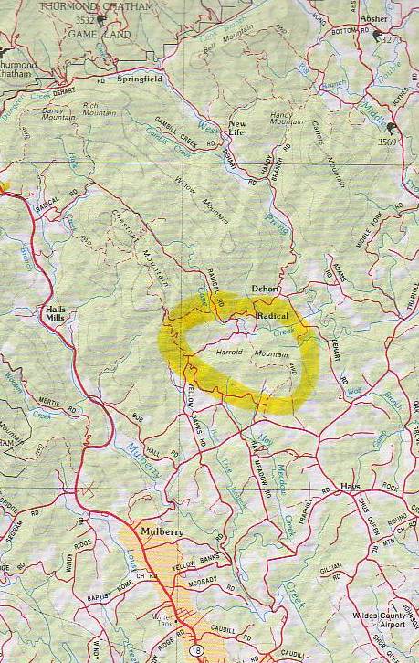
This location in Turner Hollow is where Niel McNiel’s land was located, and William’s son-in-law, Elijah Vannoy owned land located at the red balloon.  It’s a good bet that William lived with one or the other, or someplace in-between.

McNiel Vannoy land

Recently, my cousin Dolores was kind enough to take pictures of the land in this area when she visited on a genealogy adventure.  Thank you so much cousin Dolores.

To help understand what you are looking at the next few photos, let’s first look at the map of the landowners in the area.  The dot on the map above in Turner Hollow is the land shown on the map below.

Josiah Ramsey land - Niel McNiel

Cousin Dolores took the following photo from Eli Davis’s land looking toward Wallen’s ridge, meaning that she was most likely looking right at and across Niel McNiel’s land.

McNiel Hancock Wallen

This next photo is Back Valley Road near Fortner, which is shown on the following map.

McNiel Hancock Wallen map

This location would have been on Niel McNiel’s land

McNiel Hancock Wallen2

So if William didn’t live on this land, he certainly saw it regularly and it probably looked much the same then as it does now.

McNIel Hancock Wallen 3

I wonder if old William can see us today viewing the same vistas that he looked at as he looked over these fields.

McNiel Hancock Wallen 4

Did he look at these mountains and think about Wilkes County?

McNiel Hancock Wallen 5

I want to drink in what he saw and I’d so like for him to tell me about these fields and lands himself.

McNiel Hancock Wallen 6

The hills in this area are more rolling than the land in Wilkes County.  This could have been part of the allure of moving.

McNIel Hancock Wallen 7

Nothing more American than barns – although William’s barn, if he had one, would have been much smaller.

McNiel Hancock Wallen 8

William is assuredly buried here someplace, but where?  There is a Davis family cemetery on the Eli Davis land.

McNiel Hancock Wallen 9

What a beautiful place to spend your life, not to mention resting eternally.  He is assuredly buried someplace on these lands.

I don’t know, but I suspect that William died about 1817.  He stopped witnessing things and being involved in any way.  He had a long history of public service in Wilkes County and there is no reason to think that would change unless his health changed.  Secondly, his daughter Lois named a son born about 1816 William Vannoy.  William may not have gotten to spend much time living in Claiborne, now Hancock, County at all.

William’s Children

Many of William’s children carried on the tradition of local involvement and public service.

  • Sarah or Sallie McNiel, named after Elizabeth’s mother and possibly William’s mother as well, was born about 1784 and married Joel Fairchild in Wilkes County. They moved to Claiborne County where Sallie died on January 2, 1861 and is buried in the Fairchild Cemetery in Hancock County. She had 5 children.
  • George McNiel, named after William’s father, was born on September 21, 1786 in Wilkes County and died in 1870 in Claiborne County, TN and is buried in the McNiel Cemetery, probably on his own land. He married Nancy Baker in Wilkes County in 1809, having 11 children, and married Matilda Yeary in 1845, having two more children. Where he lived when he died is unknown but the land he purchased in 1816 was near Mulberry Gap on Powell Mountain.
  • Lois McNiel born about 1786 and married Elijah Vannoy about 1807 in Wilkes County. Lois died in the 1830s in Claiborne, now Hancock, County, TN. She had 10 children.
  • Neil McNiel was born about 1792 in Wilkes County and died in 1839 in Claiborne County, TN. He is likely buried on his own land, but whether he is buried in Hancock County or in Claiborne in the Little Sycamore Community is uncertain.   Neil married Elly Ramsey, daughter of Josiah Ramsey, pioneer settler of the Ramsey family and neighbor. They had only three known children, although there were likely more.  Elly is likely buried in the old Josiah Ramsey cemetery, and Niel could be buried there beside her.
  • Mary was born about 1792 in Wilkes County. She married Robert Campbell in 1817 in Claiborne County and died in 1881 in Bradley County, TN. I show only one child for her, Anderson, but I have a very difficult time believing she didn’t have additional children.
  • Nancy McNiel born in 1794 in Wilkes County married Alexander Campbell in 1815 in Claiborne County and is shown with only 3 male children. She died in 1839 in Hancock County.
  • John McNiel was born July 1, 1803 in Ashe County, NC and died in 1882/1883 in Claiborne County. In 1824 he married Elizabeth Campbell, sister to the spouses of two of his siblings. They had 8 children.

John McNeil b 1803

  • Elizabeth McNiel, named after her mother, born between 1800 and 1810 married Andrew McClary. The 1840 census shows them with 2 daughters, but I can’t find the family in 1850.
  • Jesse McNiel born about 1806 in Ashe County, died in 1890 in Claiborne County and married Bettie Campbell in June 1837. I have no information about their children. In the 1850 census, Jesse is living with his brother. I don’t find him in the 1860 census.
  • William McNiel, named after his father, was born about 1812, although where is uncertain. He could have been born in Claiborne County. In 1839 he married Nancy Gilbert and in 1849, he married Nancy Carter. I have no record of children for William and I do not find him in the 1850 census, although in 1860 we do find him in Hancock County with 3 children and he lists his birth location as Tennessee.

Some of William’s children were merchants in the small town of Sneedville, as told in various local history books.

At Greasy Rock, later known as Sneedville, Hancock Co., a store was opened in front the of the dwelling of Mrs. Elizabeth Campbell facing Main St. by Robert and Alexander Campbell and William and John McNeil with William McNeil as manager.  John McNeil eventually settled on Little Sycamore in Claiborne County where he was engaged in farming.

Little Sycamore Baptist Church in Claiborne County was built on land donated by John McNiel in 1840.  John NcNiel was trustee and the leading man in the organization and in the affairs of the church until his death in 1882.  The original church was built of logs and the plaster on the walls was mixed with cow hair to hold it together.  The hair came from John McNiel’s tannery nearby.  Members would come to church in the daylight, but would return home in the dark by the light of pine torches.

The church was used during the Civil War as a hospital for wounded Confederate soldiers.  Local people came to help tend the wounded.  Those who died were buried in the cemetery above the church, but some were removed and taken to their homes after the war.  I would not be the least bit surprised if John weren’t buried in that same cemetery

William’s son, John, seemed to have taken after his father in a number of ways – not the least of which was in the establishment of a Baptist church.

DNA

I was very fortunate that a McNiel cousin was willing to DNA test several years ago.  To date, there is still only one known cousin who has tested.  Ironic given that the Reverend George McNiel had many children and descendants.

However, that known cousin has several matches that are quite interesting and prove that other McNiel families, by other spellings, in other places are indeed from the same original family line.

  • Thomas McNeil married in 1750 Rombout, NY
  • Hugh Neel b 1750 Ireland
  • William McNeill b 1851 Blackbraes, Stirlingshire (a mining location in the central lowlands of Scotland)
  • Shamus O’Neal b 1775 County Mayo
  • Aystin McGreal b 1780 County Mayo
  • Maurice McNeely from County Antrim, Northern Ireland
  • Roger McNally from County Monaghan, Ireland (border between Northern Ireland and Ireland)

There are really two things I’d like to solve utilizing DNA.

First, was Thomas McNiel in Spotsylvania County the brother of Reverend George McNiel?  Maybe better stated, do they share a common paternal ancestor?  Clearly Y DNA testing cannot prove that Thomas was George’s brother, but it can certainly prove that he wasn’t.  Thomas is believed to have migrated to Caswell County, NC where he died before December of 1781.  He had sons, John, Thomas and Benjamin.  Several years ago, I was corresponding with a lady who descended from this line and there were males at that time.

I would very much like to confirm Thomas as a probable brother to George, or put that speculation to rest forever.

Looking at my cousin’s Y matches, I don’t see any evidence that Thomas’s line has tested nor do I see any matches to that line on his Family Finder results.

I then checked the Family Finder results of other McNiel descendants – and found no matches to the Thomas of NC either.  However, there’s nothing to indicate his line has ever tested.

I checked Y search, and no McNiel’s are found by any surname spelling who descend from Thomas.

I checked the MacNeil Y DNA project to see if someone listed Thomas, and so far, nothing, although there are several who list no “most distant ancestor” information, and Thomas could be one of those lines.

I decided to do a search at Family Tree DNA, utilizing their new search function, on Thomas McNiel who married Ann Tolbert to see if anyone has a tree uploaded on Family Tree DNA who descends from this man – and there are at least two – although we can’t tell is this is a Y, mitochondrial or autosomal test.  I sure wish there was a way to contact these people, but as of today, there isn’t, nor is there a way to determine if you match these people aside from going through each and every tree that has a McNiel listed in the matches list under ancestral surnames.

Secondly, I very much want to match a McNiel who knows where their family was from in the British Isles – and I don’t mean a large city.  What I’m looking for is the ancestral village.

When I look at my cousins matches, he has Y DNA matches with several O’neals, some Neils and Neills, a couple McNeills, one McNellis, one McNece, one McNally, one McNeely and a McGreal from County Mayo – but no specific location in County Mayo is listed.

Mayo map

County Mayo is in the western part of Ireland and is not in the English plantation area which is today, Northern Ireland.

Then, we also find County Antrim in Northern Ireland, County Monaghan in Ireland, bordering Northern Ireland and then Stirlingshire in Scotland.  Certainly nothing definitive.

If you look at my McNiel cousin’s 67 marker European matches, you’ll see the following map.

McNIel 67 marker match map

This northern Ireland location is very suggestive of an ancestral location for our McNiel line, but the Mc part of McNiel suggest perhaps Scots-Irish, as does the northern Ireland grouping of matches.  Northern Ireland was the Ulster Plantation region.

We’ve made progress over the years, but we’re just not quite there yet.

Hope springs eternal.

I guess one might say that the paternal McNiel ancestors “got around,” leaving their DNA scattered across Ireland and Scotland and the name spelled just closely enough to be confusing – and intriguing!  Nothing like a good family mystery to peak your curiosity!

Of course, with this line being descended from Niall of the 9 Hostages, it’s possible that some of these various lines simply adopted the surname based on their ancestral heritage and are not actually descended from a common ancestor since the advent of surnames.  Generally, when people of the same surname match, the assumption is that the common ancestor is since the adoption of surnames…otherwise the surnames wouldn’t match.  In this case, with the widespread fame of Niall of the 9 Hostages, I don’t think the common surname can be assumed to mean that the common ancestor occurred after the adoption of surnames.  Leave it up to my family to cast doubt where others find certainty!

______________________________________________________________

Disclosure

I receive a small contribution when you click on some of the links to vendors in my articles. This does NOT increase the price you pay but helps me to keep the lights on and this informational blog free for everyone. Please click on the links in the articles or to the vendors below if you are purchasing products or DNA testing.

Thank you so much.

DNA Purchases and Free Transfers

Genealogy Services

Genealogy Research

Britain’s Forgotten Slave Owners

Forgotten Slave Owners

Thomas Thistlewood arrived in Jamaica in 1750 from England, having failed at farming, at age 29.  He met with a plantation owner for dinner shortly after his arrival, and 2 months later became an overseer on that plantation.

Thomas kept an extensive journal of his entire life in Jamaica beginning with the day he arrived – including the horrific brutality that he inflicted on enslaved people, along with the other overseers in the same position he held.  Thomas’s behavior does not appear to be unique.

As genetic genealogists, we sometimes wonder at the extent of sexual interaction between plantation owners, their overseers and enslaved women.

Thomas’s diary details his sexual encounters – over 4000 in total, mostly with enslaved women, over a period of 37 years.  If you’re doing the math, that means that he had 108 encounters with women every year, on average, which is one approximately every 3.38 days.

If one can assume that he did not choose to engage in sexual activity with women who were menstruating, and that he probably did not select for women who were pregnant, that means that the women he was having sex with were fertile women who could have potentially conceived as a result of the encounter.

If we eliminate the one quarter of the month a woman is menstruating – that leaves 3 weeks.  Of that, a woman is fertile for about 6 days per month, or about one third of the time she was not menstruating.  Therefore, Thistlewood perhaps impregnated one women every three encounters, or about one female impregnated every 10 days, or 3 per month.  If this is anyplace near accurate, Thomas Thistlewood could have had approximately 1333 children, roughly half of which would have been male, and all of whom would have been enslaved.

Not all of the children would have survived birth or infancy.  In fact, the harsh and fatal discipline methods Thistelwood so routinely describes may have killed some of his own offspring on the plantation where he was overseer.  The mortality rate of slaves at every point in life was exceedingly high.  But some of those male children would likely have survived and reproduced, having direct line males living today.  When they DNA test, they will match Thistlewood males from England.  And they will wonder why.

Now, they need wonder no more.  The answers are in the British Archive records listing slave owners and the records in the Caribbean.  And not just for Thistlewood, but for other British surnames as well.  Many, many other British and Scottish surnames.  You can search at this link to find those records and they are also available on Ancestry.com.  For once, I was very relieved to not find my family surnames included in a set of records.

In 1834, the British government recorded payments to British slave owners when Great Britain abolished slavery and owning slaves entirely.  This effectively freed the slaves after they served another 6 years working for their former masters for free.

These records include more than 40,000 British who owned slaves, most of whom had never seen a Caribbean plantation where their slaves were located.  These slaves were managed by overseers, like Thistlewood.  There were more than 800,000 individual slaves named in 1834, which means the average number of slaves owned per British slave owner was about 20.  Of course, the real numbers ranged from 1 slave owned to thousands for the most wealthy.

Before I watched this documentary, I never realized the massive extent of either British involvement in slavery into the 1800s, nor the level of abuse of power of slave-owners and overseers exploiting slave women.  Seeing these almost unbelievable numbers and realizing that this sexual behavior lasted, for one man, for 37 years – and multiplying that behavior by thousands of other men – the level of chronic, systemic nonconsensual sexual exploitation is almost beyond comprehension.  Of course, today we can expect to see the results in Y DNA testing.

You can watch the BBC documentary at this link.  Part 2 is available at this link.

Professor Catherine Hall lectures on “Britain and the Legacies of Slavery” and the project that produced the results upon which the documentaries above were based.

All three of these videos are eye-opening and well worth watching.

If you want to read more about the history of slavery in the British Isles, click here and here.

______________________________________________________________

Disclosure

I receive a small contribution when you click on some of the links to vendors in my articles. This does NOT increase the price you pay but helps me to keep the lights on and this informational blog free for everyone. Please click on the links in the articles or to the vendors below if you are purchasing products or DNA testing.

Thank you so much.

DNA Purchases and Free Transfers

Genealogy Services

Genealogy Research

J.K. Rowling – Who Do You Think You Are – “Bravery Against All Odds”

JK Rowling

Famed Harry Potter author and philanthropist JK Rowling is eager to trace the  French roots of her maternal side, having always been very close with her mother who’s passed away. She knows that her great-grandfather, Louis Volant, received the Legion d’honneur for his WWI efforts, and she has the medal, but she doesn’t know why.

At the National Archives of Paris, Jo pours over Louis Volant’s Legion d’honneur records. She finds a fascinating tale of bravery, but is surprised and confused to realize the man in this account is actually not her ancestor. Since there are no other “Louis Volant”s in the National Archives database, Jo travels to the Military Archives outside of Paris to see if her great-grandfather did, in fact, win a Legion d’honneur award.

At the Military Archives, Jo finds the correct war records for her Louis Volant. She learns that in WWI he found himself caught unexpectedly, and with barely any training, in a battle when Germans attacked his regiment in France. Louis Volant heroically took command of his troop and killed several German soldiers to save his regiment. Jo is overcome with tears and receives a very special gift.

Enthusiastic to continue tracing Louis’s line even farther back, Jo heads to the Paris Hospital Archives to learn about Louis’ early years and his mother, Jo’s 2x great-grandmother, Salome Schuch.

At the Paris Hospital Archives, Jo discovers that when Louis was born, Salome was an unwed servant working nearby in Paris. As an illegitimate son, Louis’ given last name was “Schuch,” making Jo wonder how he became a “Volant.” Jo sets off to meet with a historian at Salome’s former home where she worked as domestic help to see what else she can uncover about both of her ancestors.

It’s amazing to watch Jo climb all those sets of circular stairs and realize that her ancestor, Salome, did as well, as a pregnant servant, likely carrying heavy loads, and trying to hide her pregnancy.

A historian shows Salome’s workplace to Jo, and reveals that Salome would have been out of employment upon having a child. But documents reveal that some years later, Salome moved up in the world, becoming a dress maker and marrying Pierre Volant, who took on Louis as his own son.  It’s unclear whether or not Louis is his biological child.  Y DNA testing could resolve that question, if there were male Volant descendants of both Louis and one of his “brothers” available to test.

Next, Jo travels from Paris to the village of Brumath by the German border in France, to learn more about Salome and where she grew up.

At the Brumath Town Hall, a census reveals that Salome had five other siblings and that the family was rather poor.

Salome’s mother’s death certificate creates new questions for Jo as she sees it is written in German and not French; a result of the area changing hands from France to Germany during wartime. To learn more about the German occupation of Brumath, Jo meets with a historian to uncover new information.

Jo visits the house where Salome grew up in the small village of Brumath, and learns that during the Franco-Prussian war, Salome and her family endured an invasion of thousands of German soldiers, and found their lives in upheaval as the land, once French territory, became German. Jo learns that townsfolk were given the choice to remain in their homes and become German citizens or move to France to retain their citizenship.

What did Jo’s family do?  You’ll have to watch to find out.  Sunday, August 2 at 9/8c on TLC, The Learning Channel.

______________________________________________________________

Disclosure

I receive a small contribution when you click on some of the links to vendors in my articles. This does NOT increase the price you pay but helps me to keep the lights on and this informational blog free for everyone. Please click on the links in the articles or to the vendors below if you are purchasing products or DNA testing.

Thank you so much.

DNA Purchases and Free Transfers

Genealogy Services

Genealogy Research

John Harrold (c1750-1825), Forger?, 52 Ancestors #82

My earliest identified Harrell ancestor is John Harrold (also spelled Harrald, Harald, Harold, Harrell, Herrell, Herald, Herrald, Herrold and any other way they could think of to confuse me) who died in Wilkes County, NC in about 1825. His wife, Mary died in 1826. His known children were born beginning in 1782 or 1783, so he had to be born before 1760 or even earlier.  The 1800 census shows John to be over the age of 45, so that tells us he was born before 1755.  Given the information I found in his Revolutionary War service records, I’m betting be was born around 1750.

It’s a good thing we have John’s death year and the census information, because much of the other information about his life is quite murky.  It has been quite a journey with more than one very unexpected crook in the road.  Come on along for the ride!

Visiting Wilkes County, NC

I visited Wilkes County in 2004 and asked my cousin, George McNiel, a local historian and avid genealogy researcher, to take me on a tour of all of my family lands.  There is a mountain named Harrold Mountain today.  I would never have put Herrall or Herrell, the surname in Hancock County, Tennessee and Harrold Mountain in Wilkes County together were it not for George and his knowledge of the area and families.

Harrold mountain

Cousin George took me to the grave of old John Harrold only to discover the single grave is gone and a chicken house stands in its place.  I don’t mean a cute little chicken house like grandma had, but a huge factory chicken house that stinks to high heaven.  How sad.  For both my ancestor and the poor chickens.  My cousin said this isn’t unusual because the only flat place large enough for a chicken house (40×100 feet) is often old graveyards, so off go the stones and in goes the chicken house. I wonder what old John Harrold thinks about that.

John Harrold burial

According to cousin George, this is the location where old John Herrell’s (Harrold, Herrald) grave used to be.  The chicken house is on the left, just out of sight.  This is on the top of Harrold Mountain.  John lived here during his lifetime and was probably buried in his own backyard.

This is either the same place or very near where his son John is also buried, known as the Brown Family Cemetery, shown on the map below.

Brown Harrold Cemetery map

FindAGrave has photos of the cemetery, before and after a cleanup effort.

Brown Harold cemetery before

Above, the Brown/Harrold cemetery before, which makes me wonder if the cemetery really did still exist but we missed it.  Although having said that, if anyone would know, it would be George.  He and his late wife spent more than 20 years surveying, inventorying and documenting every grave and graveyard in Wilkes County.

Brown Harold cemetery after

There is a family legend that says that John Harrold died in 1783 and was buried up on Harrold Mountain with all of his money and someone dug him up and robbed the grave. Of course, the speculation was that the culprits were his kids.  I guess that’s one way to take it with you – but I’ve always had these comical visions of several adult children sneaking up the mountain and running into each other at the grave in the dark. After the fight that would surely have ensued – who knows how many are actually buried in that grave:)

The story is interesting, but the 1783 death date is incorrect (because John wasn’t yet in Wilkes County in 1783 and he didn’t die until 1825) and would lead us to believe that maybe it was John’s son, John Harrald (Jr.) who was born in 1783.  We know he was buried on Harrold Mountain.  Regardless of the specifics, which we will never unravel now, the story is charming and there is surely some nugget of truth in there someplace, or the story wouldn’t exist at all.

So, John’s grave may have been twice insulted – once by grave robbers and once by a chicken farmer.  I don’t think John is resting in peace.

The fact of the matter is that the original John Harral (the name in Wilkes County is typically spelled Harrold and Harrald) didn’t die in 1783 and appears on the 1800 census with a male and female over 45, one male under ten which is probably son William, one male 10-16 and one daughter 10-16.  In addition, his presumed son, John Harrold Jr. is also enumerated with one male age 16-26, a female the same age and one female under the age of 10.  John (the elder) also appears in the 1810 census with his wife and only one child, the son who was 10-16 in 1800 in 1810 is listed as age 16-26.

The Church

Zion Baptist Church is a very old “primitive Baptist” church on Harrold Mountain and guess what the names are on probably 80% of the graves – yep – you guessed it – Harrold/Harrald.

Zion Baptist Church

A local cousin is a member of the Primitive Baptist Association, of which Zion Baptist is a member as well.

According to the cousin, this church was established in 1861. The white church above is the second building and the remnants of the original log cabin are found in the woods.  I suspect there was a church here long before 1861 given the remoteness of the area – simply that the church wasn’t a separate building and probably met at someone’s home before the log cabin.  It’s the only church on Harrold Mountain, so it’s a good bet that old John Harrold was a Baptist.  At least one of his children was married by a Baptist preacher.  John’s descendants were and are members of this church, that’s for sure.

The articles of faith upon which this church operates are posted on the wall.

1)       We believe in one only true God, Father Son and Holdy Ghost, and these three are One.  1st Timothy 2:5, Eph 4:6, 1st John 5:7

2)       We believe that the scriptures of the old and new testament are the word of God, and the only rule of Faith and practice. St. John 1:14, 2nd Timothy 3:16, 1st Peter 1:21

3)       We believe in the doctrine of election by Grace.  St. John 1:14, 2nd Timothy 3:16, 1st Peter 1:21

4)       We believe in the doctrine of original sin and in mans importency (sic) to recover himself from the fallen state he is in by nature, by his own free will and ability.  St. John 6:44, Romans 5:12-18

5)       We believe that sinners are called, converted, regenerated and sanctified by the Holy Spirit, and that all who are thus regenerated and are born again by the Spirit of God shall never fall away.  St. John 6:63, 10:28, 2nd Peter 1:10, 2nd Timothy 1:9, 1st John 3:9, Revelation 22:17

6)       We believe that sinners are justified in the sight of God only by the imputed righteousness of Jesus Christ.  Romans 5:1, 10:4, Ph. 3:9

7)       We believe that Baptism, the Lord’s Supper and feet washing are the ordinances of Jesus Christ and that true believers are the only subject of these ordinances, and we believe that the only true mode of Baptism is by immersion. Mark 1:9, 16:16, John 13:8-17, I Cor. 11:23-26

8)       We believe in the Resurrection of the dead and in general judgment, and that the joys of the righteous and the punishing of the wicked will be eternal.   Mat. 25:31:32, John 5:28-29, 1st Timothy 4:16.

9)       We believe that no minister has a right to administer the ordinances of the gospel except such as the regularly called and come under the imposition of hands by the presbytery.  Mark 3:14, 2nd Cor. 3:6, 4:1, 5:18, 1st Timothy 1:12, 4:14.

You can see the location of the church in proximity to the Harrold lands.  In order to help judge distance, it’s about 500 feet from the church to Yellow Banks Road, so less than a mile to John Harrold’s land above Harold Mountain Road.

Zion Baptist map

My cousin George, quite a history buff, said this was the last one of the old local churches to flatten the top of the graves for mowing. Apparently this particular denomination believed in rounding the tops of the graves – and keeping them mounded up. I don’t know why. They also had an outside eating area because they don’t believe in having food inside the church. These are still common practices of this particular sect of Baptists apparently, but most of the churches have modernized a bit.

You can see in the photos below, there were still mounds on a few graves.

Harrald at Zion Baptist

Zion Baptist cemetery

The photo below is standing at the church looking across the road and at the beautiful view of Harrold Mountain.  This is the exact view John Harrald would have seen, well, minus the silo.

Harrold Mountain across from Zion

John Harrold’s wife was named Mary. She is credited with saying that when she died, she wanted to but put up on the bluff on top of Harrold Mountain and to let her fly back to sweet old Ireland. I guess we know where she was from, if the story is true, but we have no idea who she was. Given that my cousin only said something about one stone where old John was buried, I couldn’t help but wonder if they had in fact put her on the bluff. I don’t know how they could find the bluff though, as it is very overgrown.

Harrold Mountain bluff

Above is the bluff of Harrold mountain, pieced from two photos, visible behind the tree and fence rows.

Tracking John Harrold

I will be spelling John’s name in the way it was spelled in the various documents that I’ve found.  Clearly, with a name like Harrold, it was quite likely to be spelled however the clerk decided it was to be spelled at that moment.  There was little consistency.

We first find John Herold in Deed Book C-1 in Wilkes County, on page 334, on July 6, 1794 a transaction between Robert Powers of Rowan County, NC and  John Herold…negro winch and mulatto child called Pink and Rose…property lately purchased in Camden…but if Robert Powers returned 75 pounds of indigo (sample whereof is in Herolds house) to Herald the above obligation to be null and void.  Signed by Robert Powers, witnessed by David Baxter.  Proven in open court February 1802 by comparison of hands writing by oath of Betsy Herald and William Young. Proven in open court July term 1804 hand writing of David Baxter by William Young, Esq.  The fact that this took place in 1794 but wasn’t registered until 1802/1804 suggests that indeed, the indigo was not returned and that Robert Powers either wasn’t cooperating or had died.

This of course begs the question of who was Betsy Herald.  John Herald (born in1782/1783) married a Betsy McKinney and that is likely the Betsy who gave her oath.

I have to wonder what caused John to be in possession of 75 pounds of indigo dye in the first place.

John Harrold appears in the Wilkes County court records on November 3, 1796 with an order from the court for the sheriff to sell 100 acres of property of Thomas Adams taken by execution to satisfy a judgment recovered against him by John Harrold, which judgment obtained by plaintiff in Iredell County execution issued by George Brown, Esq.

This is the first hint we have as to where John was “from” before we find him in Wilkes County.  Am I very grateful for this tie.

Iredell was formed from in 1788, so I checked the Rowan County records which begin in 1753 and found no John, with the exception of tax lists.  There is an early Hugh Herrill there as well, but his Y DNA line is not the same as John’s.  John Harrell is found on a 1785 tax list in James Crawford’s Company with one white poll and no land.

Extracting Iredell County records, specifically the minutes of the Court of Pleas and Quarter Sessions from 1789-1800 transcribed by Shirley Coulter we find a little more information about John.

On page 46, on August 24, 1792, a list of men is given who took the oath of allegiance and Jno Herril is included.  Of course, this might not be our John.  I wonder why he had to take the oath if he was a veteran and why this late.  The Revolutionary War had been over for years.

On February 17, 1796, a jury was ordered to lay open a road on part of Brush Mountain Road to go around a field of Robert Bogles, agreeable to his petition.  John Harrold was one of the men to lay out this road.  The Brushy Mountains are found in the northwest part of Iredell County.

The Deed Book from 1797-1802 shows a sale on October 5, 1798 from John Meadows to George Roberts on the waters of S. Yadkin on which John Harreld and David Roberts are listed at witnesses.  This deed was recorded on January 21, 1802.

An 1802 record from Rowan County Will Abstracts on page 113 shows the probate of the will of Stephen Roberts on January 9, 1802.  His wife is listed as Phebe and he lists children Warren, Joshua, Thomas, William, daughter Polly Harold, daughter Molly Noreton, daughter Judith Egmond, daughter Phebe Richmond, daughter Nancy Roberts and Betsy Roberts daughter of son William.  Polly is a nickname for Mary, but none of the sibling names look familiar, nor did John and Mary Harrold name a child Stephen, so this is likely not our John Herrald’s wife.

The 1800 census of Wilkes County shows Michael McDowell, Jacob McGrady (the minister who married William Herrell and Mary McDowell), and both John Herrell Jr. and Sr. (spelled Harrall) on adjoining pages.  Based on this evidence, pending further investigation, it is presumed that Michael McDowell is the father of both Mary and John McDowell and John Herrell Sr. is likely the father of William Herrell.

John Herral appears on the Wilkes County tax list in Captain Carltons District in 1800 with 1 white poll and no land.

In 1805, J? (smeared) Herrell had 550 acres and no polls, and James Herrell had 180 acres and 1 poll.  It’s interesting that John had no polls in 1805.  This could be because he was elderly, because he was an official, like a sheriff, although there is no evidence of that, a minister, but again, no evidence, or because he was disabled.  We know that by 1790, John had 6 children, so had been married a minimum of 13 years.  If he was 25 when he married, that means he was born about 1752.  He could have been born earlier.  If he was born in 1752, he would have been 53 or older in 1805, so possibly “elderly.”  The age where one didn’t have to pay polls varied by state and time and I’ve seen it range from age 45 to age 70.

In 1802, on page 345 of Deed Book F-1, John is mentioned in a land grant to Reuben A. Carter for 100 acres on Chathis Quemin Branch, the waters of Haymeadow and on John Herold’s line.  This is probably Chinquepin Branch.

This is followed on page 353 of the same book by a transaction on July 31, 180(blank) from Richard Allen, late sheriff and John Fletcher, Sr., land lost by Reuben A. Carter, court action brought by James Fletcher, 100 acres part of 200 acre tract on the waters of Cathinquemin Branch of Haymeadow on John Herold’s line.  Witnessed by John Saintclair and Hugh Brown.

John’s daughter, Elizabeth, married Reuben Carter in February of 1803.  This had to be a very upsetting time for the family, possibly in multiple ways.  Why did Reuben lose his land?  Was he irresponsible or unlucky?  Did he lose his land before or after he married Elizabeth?  Did they move in with her parents whose land abutted Reuben’s?

In 1803, in Deed Book F-1, on page 87, Charlotte Harrold witnesses a deed between Reuben Carter and William Sabastian for $10, 100 acres on Rock Creek, on Henry Carter’s corner and the road.  Also witnessed by William and Nancy Carter.  Charlotte was John Harrold’s daughter and married Coonrod (Koonrod) Dick in 1806.

John’s Land

Land grant entry number 1246, file number 2421 for 200 acres was filed for John Herrold on November 16, 1801 and states that the land is on the Chinquepin Branch of the Hay Meadow Creek on the waters of Mulberry beginning near the head of the said branch and that it is against Michael McDowell’s line.  The survey was entered November 16, 1801 and was actually recorded in February 1802.   Chainers were John Roads and Michael McDowall.  There is a drawing of the survey but it just looks like a square and there are no watercourses noted.  The fact that the land was at the head of the branch tells us it was high up on the mountain.

Note that John Harrold’s son, William, would marry Mary, the daughter of Michael McDowell, in 1809.

John Herrold grant

The grant of land was not actually made until December 5, 1811 and it is grant 2817.  It’s odd that John would not own land until this late in his life.  He was approximate age 50 in 1800.

The name is spelled variously Herrild, Herrald, Herrold.  John paid “4 pounds” for this survey in 1804.  I find it interesting that they are still using the old English money measures and not dollars.

In 1811, in Wilkes County Deed Book G-H we fine a David Harrill of Surry County, NC selling land to Jesse Allen for 200 pounds, 550 acres on Joshua Mizes line, the waters of Hunting Creek, witnessed by Richard Alley and Hugh Riley.  Hunting Creek is not near John Harrold’s land, more than 5 miles distant as the crow flies, southeast of Wilkesboro.

There is no known connection between David and John Harrell, but just because a connection isn’t known doesn’t mean it doesn’t exist.  Furthermore, we don’t know how David obtained this land, because he isn’t listed in the deeds or grants.

Haymeadow2

haymeadow3

John’s land is located on Haymeadow Creek.  You can see Mulberry to the lower left on the map above.

Haymeadow and Harrold

Haymeadow Creek runs right up beside the Zion Church and on up paralleling Harrold Mountain Road until you reach the beginning.  As we know  from the land grant, the beginning or headwaters of Haymeadow is where John’s land was located.

John’s land is very likely where his son, John’s land was located, where the cemetery is, or rather, was located, which is between the Harrrold Mountain Extension and Waddell Drive, above and below.

John's land

John’s land was about as far up as you could go on Harrold Mountain, which of course, wasn’t yet named Harrold Mountain at that time.  200 acres would have been just about all of the land above the Harold road U on the map above, including the central extension.  The original homestead was likely on the left near the cemetery.  Michael McDowell’s land abutted John’s at the southwest corner where they shared a stake and eventually, Reuben Carter’s would abut John’s land too.

John Harrold satellite

If you look at this picture, all of that treed land above John’s land is too mountainous to do anything with.  Very steep and wild.  That one little road you see is a two-track that leads to nothing.

A Willliam Herrell was witness to a will of Benjamin Sebastian in 1818 in Wilkes County.  John Harrold was a witness also.  This is likely not William, John Senior’s son, because John’s son, William, went to Claiborne County, Tennessee about 1810.

By the time John Harrold Sr. died in 1825, his son William had been gone for 15 years.  I wonder if John ever saw William again.  Did he know when William was pulling away in the wagon that it was their final goodbye?

William wasn’t the only one of John’s children to leave.  In fact, the only child we know of that stayed in Wilkes County was son John, who likely lived on John Sr.’s old place.

Harrold goats

These two photos were taken on Harrold Mountain on a beautiful spring day with the goats frolicking to celebrate the fresh spring grass.  It probably looks about the same today as it did when John Harrold lived there.

Harrold goats2

John died sometime in 1825, because in October of that year, in Will Book 3-4, on page 78 is recorded the account of sale of the estate of John Harrold.

In January 1826, an allowance was made to Mary Harrold, widow and in October of 1826, the estate sale of Mary Harrold was held.

John Herrell was born in roughly 1750 or before and died in 1825 in Wilkes County NC.  He is buried someplace on Harrold Mountain, probably on his own land.  Today this mountain remains very rugged and remote.  His grave is either marked with a chicken house or he is buried in the same cemetery as his son John.

John’s Children

What we know about John’s family is somewhat limited, but at least some of his children have been identified.

Of John’s known sons, one, John, stayed in Wilkes County and is the progenitor of the family there today.  William went to Claiborne County, Tennessee and the family surname is generally spelled Herrell or Harrell,  Alexander went to Breathit Co., KY where the name is Harrold and Herald.

  • William Harrell, born 1790 in NC married Mary McDowell, daughter of John’s neighbor Michael McDowell, in 1809 in Wilkes Co.  They were married by the Baptist Preacher, Jacob McGrady. They moved to Claiborne Co. shortly thereafter. They lived for a short time in Lee Co. Va. before purchasing land in Claiborne Co. in 1812. This is my ancestor.
  • John, born 1783, died in 1879 in Wilkes Co.  He married Elizabeth, “Betsy” McKinney about 1797.  Most of the Wilkes Co. Harrold’s seem to be descended from this man. John also lived on Harrold Mountain, probably on his father’s land, and is buried in the Harrold/Brown Cemetery.

Brown Harrold cem

You can see it closup here, the trees in the middle of the field to the right side of the photo.

John Harrold Cemetery closeup

John’s gravestone says he was born in 1782 and died in 1879.

John Herrald b 1783 stone

  • Elizabeth, born in 1785 married Reuben A. Carter in 1803 in Wilkes Co. No more is documented about this couple, but they may have gone to Maury County, TN. by 1815 and then on to Crawford County, Missouri.
  • Alexander Herrell born about 1785 in North Carolina, died about 1860 in Breathit Co, KY, married Elizabeth Turner before 1812 and moved to Breathit County shortly thereafter. The 1850 census where the name is spelled Herrald shows that he was born in North Carolina.
  • Charlotte, born about 1790 married Koonrod Dick in 1806 in Wilkes County. She and Koonrod or Conrad moved to Simpson Co. KY before 1825.
  • James, possibly a son of John, listed here because of his residence in Wilkes in 1805. This is speculative and may be inaccurate. There is no further information about this man and he does not fit on the census.
  • Sarah “Sallie” Herrell born about 1784 and died in 1845, probably Breathit County, KY.  Married Jessie Turner before 1805 and had 9 children.

We are left with a couple of burning questions about John Harrold or however the surname was spelled.

Where was John from?

We know John (the eldest or first’s) son John (Jr., the second) was born in or about 1782 or 1783, that he stayed in Wilkes County.  Because John Jr. (the second) lived past the 1850 census, we can tell something about where John Sr. was living in 1782 when John Jr. was born.

The 1850 Wilkes County census tells us that John Herald was a 67 year old farmer born in Virginia.  His wife was apparently deceased and he had 5 children living at home. This would be John Jr. (the second).

The 1860 census shows us that John Harold Sr. (the second,) who lived beside John Jr. (the third) was a 78 year old farmer born in Virginia. He still had 4 daughters living at home with him, ranging in age from 22 to 31.  The Jr. and Sr. have transitioned.  The John Jr. (the second) became John Sr. when his son John (the third) reached adulthood.  John Sr. (the first) had already died by this time.  John (the second’s) son, John, became John Jr. at that time.  Jr. and Sr. can be very deceptive because of this type of transition, and also because they may not indicate a direct relationship.  Sr. and Jr. can mean “older” and “younger” in two men with the same name who are not related or not father and son, but live in the same location.

John (Jr., the second) is not shown in the 1870 census, although according to his grave marker, he was still living.

In 1880, John Jr. (the third) is still living, age 75 and he shows that both he and his parents were born in North Carolina.  His wife shows that her parents are born in Virginia, so it’s not a matter of unthinking ditto marks.  This would indicate that his father, John (Jr. the second) born in 1782, was born in North Carolina, although we have three census records where John (born in 1782) presumably gave the information himself and said he was born in Virginia – in all 3 records.

According to the census, in 1800 we find John (the eldest) with his children in Wilkes County.  In 1790, we find only a couple of candidates in North Carolina or for that matter, anyplace in the eastern half of the US.  The Virginia 1890 census does not exist and has been replaced by tax lists which I have thoroughly scoured from 1782-1787.

One candidate is John Harrald in Iredell Co NC.  He is not listed in Iredell in 1800, so this could be our John, especially with the 1794 court record referencing Iredell County where John obtained the judgment.  In 1790, this John had enough children to be our John, which is one of the qualifiers to be a candidate.  He had 1 male age 16+ (himself), 3 males under the age of 16 and 4 females.

The second burning question is related to the first, and the question of where John came from is at least somewhat unraveled as we peel the onion of the mystery of the multiple John Harrold’s who served in the Revolutionary War.

Which John Served in the Revolutionary War?

A fellow Harrell researcher sent me the following two scanned pages a couple of years ago.  They found these years ago in a Virginia library.  We don’t know what books they are from, aside from the information at the top of the page, but it does tell us that there are two Johns who served.

One John Harrell applied for a pension from Nansemond County, VA where he was born in 1761.

We know that this is NOT our John because that John applied for a pension in 1833 in Nansemond County, VA and our John lived in Wilkes County and was dead by this time.

John Harrold Rev War

The second page, below, shows a John Harrill from NC, a private, who received or applied for a land grant on July 29, 1820, for 228 acres that went to his heirs.  Unfortunately, this entry raises far more questions than it answers.  Does this mean he served out of North Carolina or only that he lived in NC in 1820 when he applied for land?

John Harrold rev war2

I found this book at the Allen County public library, and it was Revolutionary War Records of Virginia Vol 1.  by Marcus Brumbaugh.  The book explains that these records are of bounty land warrants for the military district of Ohio from the federal and state archives.  This record for John is for a private and for 228 acres.

From the article “Military Bounty Land” by Sandra Hargreaves Luebking, we find the following.

North Carolina was the most generous, giving 640 acres (a square mile) to a private in the Continental line. The tract was in Tennessee; no bounty land warrants were located within the present-day boundaries of North Carolina.

An extraordinary flood of Revolutionary War bounty-land warrants poured from Richmond, partly because Virginia had the largest state population and partly because it granted warrants not only to its Continental line but to its state line as well. The distinction rests on who paid the soldiers—Congress or Virginia.

The first military reserve was created south of Green River in Kentucky and subsequently expanded west of the Tennessee. There were no bounty lands within present-day Virginia or West Virginia. In 1784, Virginia ceded its claim to the area north of the Ohio River, reserving the 4 million acres between the Scioto and Little Miami Rivers for redemption of its bounty-land warrants. This Virginia Military District in Ohio was federal land for which first-title land grants were reserved solely for the Virginia warrants of veterans of the Continental line. A series of ever more liberal acts broadened where warrants could be used and by whom until, in 1852, Congress agreed that all Virginia Revolutionary War warrants could be exchanged for scrip accepted at any GLO land office. Large numbers of these assignable warrants were sold; an estimated one-quarter of the Virginia Military District was acquired by twenty-five men.

The paperwork flow was: (1) warrant application to Richmond; (2) warrant issued to warrantee; (3) selection of desired land in Kentucky or Ohio reserves and survey by official surveyor; (4) paperwork for Kentucky lands to the Virginia Land Office or, from 1792, the Kentucky Land Office, or the federal capital for Ohio lands; and (5) patent for Kentucky land sent to patentee or federal patent sent to Richmond for relay to Ohio patentee.

Fold3.com Records

Next, I checked http://www.fold3.com, finding several service records.

Service Records – Company pay rolls

John Harrold’s (Herrald, Harreld) Revolutionary War pay records.

Served in the late Capt. Williams Company of the 8th Virginia Regiment commanded by Col. James Wood:

  • Pay roll of Capt. John Nevils Company of the ? Virginia commanded by James Wood for the month of June 1777 – John’s pay is noted, along with a note “Deserted July 7th”.  Others who deserted the same day were Travis Chambers, William Hutcherson and John Waters.
  • Deserted July 1778, joined April 17, 1779
  • April 1779 Camp Middlebrook
  • Virginia 8th Regiment – Late Captain Wallace’s Company of the 8th Va Regiment, commanded by Col. James Wood – private June 1779 Camp Smith’s Clove to July 1
  • Same as above but dates June 1, 1779 commence pay at 6 2/3 dollars per month – for one month amount of pay 2 pounds
  • July 1779 Camp Rampo – private – enlisted May 1, 1777 for 3 years – Each one of the pay records shows this he enlisted at this date which is how you can be sure it’s the same man.
  • Aug 1779 – Camp Smith
  • Oct 1779 Camp Ramapough
  • April 1779 – 3 days pay – not drawn for since June 78
  • March 1779 – Capt Smith’s Clove’
  • June 1779 – private, Capt Smith’s Clove, Capt. Wallace’s Company commanded by Col. James Woods
  • John Herrold, Capt Wallaces Company, appears on a list of the absentees of the 12th Virginia Regiment with the sum due each: not dated, 11 48/72 dollars, absen
  • Roll of Captain Wallaces Company of the 8th Virginia for the month of August 1779 – paid for one month as a private.

Smith’s Clove is in Suffern, NY, State Route 17.  Camp Rampo was in Ramapo, New York as well, and both of these locations were headquarters of George Washington during the Revolutionary War.

This is an entirely separate record at Fold3 as follows:

John Harald – private, Capt. Abraham Kirkpatrick’s Co in a detachment of the 2nd Virginia Brigade commanded by Col. Febiger – Dec, Jan, Feb and March 1780, pay is 6 2/3 per month, subsistence is 10 per month, amount of pay and subsistence 50 dollars.

John Harold – Soldier Infantry – appears in a book under the following heading:

“A list of soldiers of the Virginia Line on Continental Establishment who have received certificates for the balance of their full pay agreeable to an act of assembly passed November session 1781.”

Signed by Mr. Hancock, June 4, 1782 for 36 pounds

Pensions

John Harrold – 1 NC Regiment – Capt. John Summer’s Company of the 1st NC Batallion commanded by Colonel Thomas Clark – roll dated Sept. 8, 1778, enlisted April 4, 1776 for 2 and one half years.

There is also a service record for John Harrold who served in the 1 NC Regiment.

John Harrolds of Frederick Co., VA and Botetourt Co. VA

VA State Library, Archives Division, Military and Land Warrants Records for John Harrold show he served 3 yrs as a sergeant in VA Continental Line, 8th VA Regiment from Botetourt Co. He was discharged June 1777 near Valley Forge then served a 2nd time for 18 months in the 8th VA Regiment and was discharged near Salisbury, Feb 1782. In 1819 he lived in Wilkes Co., NC and in 1828 was still there when he received bounty land warrant #6718 for 200 acres.

The above record drove me nuts, because while someone was kind enough to send me the info, and I was very grateful, there is no source or context, so I couldn’t reproduce it nor did I know where to go from here.

Another contributed record tells us the following.

One John Harrold was born circa 1761 in Frederick County, Virginia.  The first record of him is from a Register of Description of Noncommissioned Officers and Privates enrolled at Albermarle Court House dated 23 December 1781 in which he is described as:  “John HARRELL, age 20, born in Frederick Co., VA, 5 ft. 10 in. tall, brown hair, grey eyes, fair complexion, occupation planter, residing in Montgomery Co. VA, engaged as a substitute from Montgomery Co.”

The John Harold of Frederick County born in 1761, so only 20 when he enlisted in 1781, cannot be the John Harrold who was a sergeant when discharged in June of 1777.  That just doesn’t work.  A 16 year old is not going to be a sergeant.  He also cannot be the man whose pay records were found from 1777-1779 at Fold3.com.

Now we know we have at least three John Harrold’s serving out of Virginia, and possibly more:

  • John of Frederick County, age 20 when enlisted in December of 1781, so born 1761
  • John of Nansemond County who served from there and requested a pension from there in 1833
  • John of Botetourt County, reported to be a sergeant who eventually lived in Wilkes County, NC.  Served twice, once discharged near Valley Forge in either 1777 or 1779 and discharged the second time in 1782 from Salisbury NC.  Received a bounty land grant.
  • John who enlisted on May 1, 1777 for 3 years who is probably the same man who deserted in 1778 and rejoined in 1779.  This could be John of Nansemond but the dates seem to eliminate John of Botetourt and does eliminate John of Frederick.  After reading John of Nansemond’s pension application, he is also eliminated.
  • Possibly another John who served under Capt. Abraham Kirkpatrick in the Virginia 2nd from Dec 1779-March 1780 according to pay records – although this could be  John of Nansemond.

I requested the records for John Harrold from Botetourt County from NARA, and they replied that they had no records for him.  How could that possibly be when Fold3 digitized NARA’s records?

I think the genealogy gremlins are out to get me.

Library of Virginia to the Rescue

It pays to recheck earlier sources.  The Library of Virginia continues to digitize their records and to them, a huge, HUGE, THANK YOU!!!  I had written to the National Archives and received nothing, so this information documents three years of John’s life for me.  These records prove, beyond a shadow of a doubt that the Botetourt County John is the John Harrold of Wilkes County.

John Harrold rev war3

Downloading the images, I found the entire packet including John’s discharges and affidavits regarding his service.  A literal goldmine.  The motherlode.

john harrold rev war 4 jpg

This is to certify that the bearer herof John Harreld (or Harrold) formerly a sargent in the 8 Virginia Regiment has duly and faithfully served the term of three years for which he was enlisted for and in and at his own request is her by discharged from any further service in the Army of the Younited Stats and is permitted to pas to his home in Botod County fre and un milisted give under my hand at Camp near the Valley Forge this 12 Day of June in the year 1779.  Signed Charles Scott B G (Brigadier General)

The bearer John Hareld Sergeant is here by entitled to ? akers of land for his three years service in the Army by the Younited Stats to ?? on the ?? waters by a nek ? assembly their troups.  Given under my hand at camp near the Valley Forge these 12 June in the year 1777.  Signed Charles Scot B.G. (Brigadier General)

I originally believed the year would be 1777, not 1779.  This discharge was probably written in the commander’s tent on the battlefield, so it’s amazing that the penmanship is as good as it is

However, based on the last paragraph, for John to have been enlisted for 3 years, the discharge date would have had to have been in 1779, because that dates John’s enlistment to June of 1776.  The war had not yet begun two years earlier, in June of 1774.

Valley Forge in Pennsylvania was the site of the military camp of the American Continental Army over the winter of 1777–1778 during the American Revolutionary War. It is approximately 20 miles northwest of Philadelphia. Starvation, disease, malnutrition, and exposure killed nearly 2,500 American soldiers by the end of February 1778.

John Harrold apparently served through this time and survived

Forgery???

Interestingly enough, Will Graves, a revolutionary war historian, transcribed this document as well, and questions whether it is a forgery based on General Scott’s signature.  Although Scott is described elsewhere as somewhat illiterate.  That’s certainly an interesting conjecture and raises unpleasant questions that need to be answered.  I must admit that the service record dates we have don’t mesh entirely with the discharge papers, nor is there ever a pay record for a John who is a sergeant.  We might shed some light on this if we knew where General Scott was, exactly, on these two different dates in 1777 and 1779, but I have been unable to do so.

Will’s transcription suggests that he believes 1779 date is accurate.

Some Fold3 pay records for John Harrold state that he enlisted on May 1, 1777.  If these are all the pay records for the same John Harrold, the enlistment date of May 1777 and the discharge date of June 1779, given that he was AWOL for part of the time might make sense, although it certainly doesn’t total 3 years.  I hate it in these types of situations when I start using the words might and could, because I know I’ve crossed that speculative line.

If John enlisted for 3 years, in June of 1776, then the May 1, 1777 enlistment date doesn’t work either.

Now, I’m left with even more questions.  If one discharge was a forgery, was the second one too?  If one or both were forged, was it simply because the original was lost, or was there something more sinister and unethical afoot?  Many men stated that their discharges were lost, but then they had to produce witnesses to vouch for their service record.  Was John ever a sergeant?  Did he even serve?

Or maybe those documents aren’t forgeries at all and I’m doubting a 3 year patriot’s service record.

The 8th Virginia

The 8th Virginia Regiment, in which John Harrold reportedly served for 18 months, was raised beginning on January 11, 1776 for service with the Virginia State Troops.

If John was discharged in June of 1779 after serving three years, then it couldn’t have been our John who joined in May of 1777.  Unfortunately, these records don’t fit together perfectly.  Furthermore, the John who joined in May 1777 was a private, not a sergeant.

The Virginia 8th’s first commanding officer was patriot leader and German Lutheran pastor Peter Muhlenberg, who became a militia colonel in 1775 at the request of General Washington. In his last sermon from the pulpit, Muhlenberg read from Ecclesiastes 3:1, “There is a time for all things, a time to preach and a time to pray; but there is also a time to fight, and that time has now come.” He removed his clerical robes to show that he was wearing his uniform as a militia colonel. He quickly enlisted 300 men from his congregation in the unit that became the 8th Virginia.

Muhlenberg was appointed colonel on March 1, 1776. The 8th Virginia organized at Suffolk County Court House between 9 February and 4 April 1776. The unit’s 10 companies came from Augusta, Berkeley, Culpeper, Dunmore, Fincastle, Frederick, and Hampshire Counties, plus the District of West Augusta. On May 25, 1776 the regiment officially became part of the Continental Army.

In 1776, Virginia regiments were typically organized into 10 companies, of which seven carried muskets and three carried rifles. The regiment’s 792-man roster had three field officers, and a staff that included an adjutant, quartermaster, surgeon, surgeon’s mate, chaplain, sergeant major, quartermaster sergeant, and drum major. Each company consisted of one captain, two lieutenants, one ensign, four sergeants, four corporals, one drummer, one fifer, and 64 privates.  John Harrold was one of the sergeants if his discharge is accurate, but he is not listed as a sergeant in this unit or in any unit.

The 8th Virginia marched south to Charleston, South Carolina and was there in time for the Battle of Sullivan’s Island on 28 June 1776, but it was not in action. On 21 January 1777, the regiment received orders to join George Washington’s main army at Valley Forge.

On 11 May 1777, the unit was assigned to the 4th Virginia Brigade, together with the 4th and 12th Virginia Regiments, Grayson’s Additional Continental Regiment, and Patton’s Additional Continental Regiment. Charles Scott, who signed John Harrold’s discharge, above, was appointed to lead the brigade.

It was a long way home for John from Valley Forge regardless of when he was discharged – about 350 miles.

John Harrold valley forge

John may have returned home in June of 1779, but he wasn’t finished with the Revolutionary War.  He enlisted again by August of 1780.

John Harrold Rev War5 jpg

I do here by sertify that the bearer here of John Harrald formerly a seargeon (or sergeant?) in 8 Virginia reagiment has faithfully served the term of 18 months for which he was in listed and is permitted to pass to his home in Bottatot County in Virginia he behaving as a good citizen I fother certify that he has received no pay for his eighteen months service in the Southern states given under my hand at Camp ner Salisbuary this 16th day of February 1782.  Signed Samuel Sned (Snead) MC

If John was discharged on February 16, 1782, by subtraction, this tells us he re-enlisted no later than August of 1780.  The pay records for John Harrold in 1779 are obviously not for this John Harrold.

The 8th Virginia was absorbed into the third Virginia brigade in May of 1779, then became part of the 4th and 12th.  The discharge says he was formerly a sergeant in the Virginia 8th, but it says nothing about the unit he was serving with that was discharging him.

Assuming this service record is legitimate, this may be how John Harrold came to be acquainted with the Wilkes County area.

The Salisbury District of North Carolina, was originally one of several colonial judicial districts established in 1766. Immediately preceding the onset of the American War of Independence, these six regions, in 1775, were broadened into “de facto” militia districts.

The Salisbury District was based in the village of Salisbury, North Carolina, in Rowan County, about 60 miles from present day Wilkesboro.

The Salisbury District originally included Anson, Guilford, Mecklenburg, Rowan, Surry, and Tryon counties. A later addition was the Washington District (also known as the original Washington County, North Carolina) which covered most of the present day State of Tennessee. Eventually, as new settlements were carved out of the wilderness, the Salisbury District encompassed the counties of Lincoln, Montgomery, Richmond, Rutherford, Wilkes (all in present day NC), and Sullivan (in present day TN) as well.

It was almost 200 miles from Salisbury, NC to Botetourt County, VA.  I hope John wasn’t on foot, but I bet he was.  Horses were at a premium.

John Harrold Salisbury

Bounty Land

John appoints a power of attorney to collect his land grant based up on his service record..

John Herrald rev war 6 jpg

Know all men by these presents that I John Harrald of the County of Wilkes and State of N. Carolina have constituted and appointed Alex. ? McKenzie of the county of Wilkes and State aforesaid my true and lawful attorney for me and in my name and stead to procure and receive from such officer person or persons or shall be legally authorized to grant this same a land warrant to which I am entitled for my services rendered the United States during its revolutionary war as my original discharge certified and I hereby further empower my said attorney to give such receipts as shall be required in obtaining said lands. Patent in my name in as full and ample a manner as I myself could do were I personally present and I hereby certify and confirm whatever my said attorney shall lawfully do in the premises given under my hand and seal this 30th day of January 1819.

Signed, John Harrald

Witnessed by George W. Smith and Joshua Shumate (his mark

I believe this is John’s actual signature.  Whether or not the discharges themselves are forgeries is irrelevant to these signatures being authentic.  Note that this affidavit states that this is his original discharge.

John acknowledges the power of attorney in open Court on Febnruary 5th, 1819.

John Herrald Rev war 72 jpg

Next, John sells his claim.

John Herrald Rev War 8 jpg

Know all men by these presents that I John Harrald Sr. of the county of Wilkes and the State of N. Carolina have bargained and sold unto Alexander McKenzie my claim for 330 acres of land to which I am entitled for services rendered by me in the Revolutionary army and I have bargained and sold unto said McKenzie my claim of 18 months pay for services rendered by me during the revolutionary war in the southern states and I bind myself my heirs assignees executors and administrator to have no recourse on said McKenzie  on the claim? of said claims by ? one hundred and fifty dollars the amount in full for my said claims.  Signed under my hand and seal this the 3rd day of January 1819.

Signed John Harrald

Witnessed

Joshua X Shumate
George (W his mark) Smoot

John Herrald Rev War 9 jpg

In this document, John swears that he has not drawn the warrant for his land and that he authorizes Alexander McKenzie to do so.

This is the third example of John’s signature.

At this point, John would have been about 70 years old

Botetourt County, Virginia

Now we know that John was from Botetourt County, Virginia and that is where he considered home.  He was returning there when he was released from Valley Forge.  He also returned there in 1782 when he was released, which just happens to be the same year (or just before) that John Harrold Jr. was born.  Even if both of these discharge records were forged by (or for) John, it gives his home location as the same place in both.  That much would be accurate.

Now, we have a new problem.  There are other Harrold men in Botetourt County, leading one to the presumption that they are the same family line…but they aren’t.  There is a James Harrold there as early as 1770 living on Harolls Creek but the Y DNA of James’ line (that went to Warren Co., KY) does not match the DNA of our John’s line.

However, there is another very interesting record found in the Botetourt County records.

Botetourt County Virginia USGenWeb Archives – Court held for Botetourt County the 11th day of March, 1779.

This court doth allow Mary O’harrell, wife of John O’harrell, a soldier in the Continental Army, thirty pounds for the support of herself & two small children.

This would imply that Mary and John have been married at least 5 years.

If this is our John, then the June 1779 discharge date would be the correct one, not 1777.

Is this our John and is O’Harrell misspelled?  Are there any other instances of O’Harrell?  There are no John O’Harrell Revolutionary War service records at Fold3.com – yet this court entry clearly says he was serving and we know the records for the Virginia 8th, the unit in which he would be serving out of Botetrout County, are intact.

And then, there is this Augusta County record…

Augusta County, Virginia

Another Harrell researcher sends the following:

John Harrold (? Harrell) became an indentured servant in Augusta County, Virginia April 15, 1773. His master was Edward Cather, as the record indicates: April 15th.1773 John Harrold (? Harrell), servant to Edward Cather of Augusta Co. Virginia. Edward Cather’s parents were from Ireland and Scotland. He was born about 1740 when his parents were listed just married in Ireland. Though they say Edward was born in Virginia, his parents are listed as coming to America about 1777. Thus it is only a guess but I would believe this John Harrold also came from Ireland/Scotland and perhaps his way over were paid by the Cather’s. He was only assigned to work for two years for Edward Cather, which I would assume would reimburse his transport to America. Edward Cather quickly left Virginia for Kentucky about the time of at least the mid 1780s. Not sure if John Harrold followed.

If this is our John, this would explain why his DNA does not match with the other Botetourt or Frederick County, Virginia Herrell lines.

What Next?

It has been a long journey finding John.  The most difficult part was actually getting my hands on his Revolutionary War records.  Once I did, so many questions were answered.  We have added another chapter in the puzzle of “where was John?” and have pushed the brick wall back a little further.  We know that he was living in Botetourt County, VA in either 1779 when he was discharged after a 3 year service commitment, so he was likely living there in June of 1776 when he would have enlisted.

And of course, now we have the added mystery of whether or not John’s discharge papers are forgeries, which begs a whole new set of questions.  That was a sucker punch – and it doesn’t help that the pay records we have do nothing to corroborate John’s discharge papers.  Of course, they don’t disprove them either.  So frustrating with no clear way to obtain answers.

In all the years I’ve been doing genealogy, I have never, not once, actually seen a discharge letter of one of my ancestors, let alone two.  Maybe I still haven’t.

We are left to wonder if the Botetourt County John and Mary O’Harrell is the same as our John, in 1782.  No John Harrold, O’harrell or any similar surname appearing on the Botetourt tax lists in 1782 or as late as 1787.

We know that by 1779, John in Botetourt, based on the court record, assuming it’s our John, already had 2 children, if they survived.  The depth of their destitution is demonstrated by the fact that Mary had to ask for money to simply survive.  This is actually a very unusual occurrence and may indicate that her own family is either dead or not living locally.  John’s 1782 discharge record indicates that he had not been paid, and even had he been paid, he had no way to get the funds to Mary.

I am still very anxious to discover more about John Harrold, although short of a DNA match to another Harrell or Harrold or Harrald overseas or from earlier colonial times, I don’t quite know how I’ll ever connect the dots.  Of course, I can always pray for that Bible on e-Bay.

The good news about the Harrald Y DNA is that at 25 markers, the three descendants of John Harrold who have tested match only one other man, a Todd from Ireland with 1 mutation difference.  The three John Harrold descendants are group 7 in the Harrell DNA project.

Harrell group DNA

Thank goodness for Y DNA, because I know that we don’t descend from any of those other Herrell groups – so no need to bark up those trees.

I checked one last possibility.  There are several known descendants of John who have tested autosomally.  I checked each of them for matches to other Harrold/Harrell/Herrell lines in case we’re dealing with an undocumented adoption or illegitimate birth to a Harrold female.  So far, only one match and that person of course could match that individual on a completely unrelated line.  That match goes back to a George Troup Harrell who is attributed to a line descending from Josiah Harrell (1733-1773) and Mary Ann Gardner out of Bertie County.  Since it’s a male Harrell that we match, I’m hopeful that I can talk him into Y DNA testing.  I’m sure he’ll likely match the large Harrell Group 1 which is the eastern Virginia, eastern North Carolina group…but I’d still like to know for sure.   Y DNA doesn’t lie and it’s not ambiguous.  No forgeries or questions about forgeries.

Harrell group 1

I think today, we’ve done all with the records we can do for now.  So, now we wait, because someday, another Harrold or man with a similar surname will test and will match, and we’ll continue to chip away at that brick wall.

______________________________________________________________

Disclosure

I receive a small contribution when you click on some of the links to vendors in my articles. This does NOT increase the price you pay but helps me to keep the lights on and this informational blog free for everyone. Please click on the links in the articles or to the vendors below if you are purchasing products or DNA testing.

Thank you so much.

DNA Purchases and Free Transfers

Genealogy Services

Genealogy Research

Ginnifer Goodwin – Who Do You Think You Are – “Not What I Expected”

My favorite genealogy series, WHO DO YOU THINK YOU ARE? returns this summer on Sunday, July 26th at 9/8c on TLC with a heart-wrenching episode with actress Ginnifer Goodwin who you probably know from her “Big Love” HBO series and ABCs “Once Upon A Time” where she stars opposite her husband.

Ginnifer in the archives with books behind her.

Ginnifer in the archives with books behind her.  Courtesy TLC.

Ginnifer Goodwin knows nothing about her paternal grandfather’s family because he refused to talk about his parents. She goes on a journey to uncover the truth behind her great-grandparents’ story, and is shocked at what she discovers.

I’ll just warn you now, get the Kleenex box.  You’ll need it.

Ginnifer never knew her paternal grandfather, John Barton Goodwin, who died when she was an infant. She’s been haunted by the lack of information surrounding his family line; he never talked about his parents to her father, Tim. Understanding the generations that laid the foundation for her has grown more important to her since becoming a mother herself. The birth of her son Oliver has reignited her desire to know why her grandfather never spoke of his mother and father.

Ginnifer starts her search for information with her dad, who recalls that his father John Barton Goodwin’s parents were named Nellie Barton and John “Al” Goodwin, and that for some unknown reason, John Barton Goodwin was abandoned or left home when he was just 11 years old, making his own way in life in Memphis, Tennessee.

The last time he did any research, Tim found a 1910 Census return in which Nellie, Al and John Barton are living in Batesville, Arkansas, along with John’s older sister, Pearl.  Ginnifer wonders what could have happened for Nellie to have let 11 year old John leave her home, and heads to Arkansas to see if she can find some answers.

Local records in Batesville reveal, surprisingly, that Nellie’s maiden name was Haynes, not Barton, and a search for her marriage record returns a result for Nellie and a man named J.D. Williams, not Ginnifer’s great grandfather, Al Goodwin! Can this be right?

What happened with Nellie’s first marriage that she eventually married Al Goodwin? Was Nellie a young widow?  The local genealogist explains that death records of this time are incomplete and advises that Ginnifer visit the Independence County Courthouse to search for evidence for the other alternative to the end of a marriage: divorce records.

Next, Ginnifer meets with a historian, who has found a case for Nellie suing J.D. Williams (a.k.a. “Duff”) for divorce. Ginnifer discovers that Nellie successfully sued for divorce when Duff abandoned Nellie while pregnant for their daughter Pearl just months after their marriage.

Ginnier discovers that Duff Williams sued Nellie for divorce first, and only married Nellie to avoid jail time for having sex with her outside of matrimony. But the tables were turned when he falsely accused Nellie in court of adultery, and his lies sent him to prison.  Three years later, Nellie finally files for divorce.  Shortly thereafter, Nellie marrys Al Goodwin, Ginnifer’s great-grandfather, hoping for a fresh start.

Continuing her search for Nellie and Al Goodwin, Ginnifer finds that between 1906 and 1911, Al racked up 18 indictments for bootlegging and gambling, and served two years in prison.  She has to ask herself….was Nellie involved?

It’s about this time that my heart truly goes out to Ginnifer.  She’s finding out, but as she says at one point, ‘somehow this is not what I expected.’  Ginnifer’s tears are not cried by an actress.

In Al’s own penitentiary records, Ginnifer is shocked to see her great-grandfather’s mugshot.  She can see her father’s face in Al, and I can see Al’s face in Ginnifer as well.

Then Ginnifer discovers Al had syphilis in 1906, 2 years after her grandfather was born, while married to Nellie, and was being visited by a woman other than his wife while in prison.  It comes as little surprise that Nellie filed for divorce while Al was behind bars.  Obviously Nellie’s life was challenging, at best, and possibly much, much worse.  From later records, it appears that Nellie had another son by Al Goodwin.

In 1911, it was almost impossible for a woman to support herself, let alone with 3 children, without a husband.  Ginnifer’s grandfather would have been about 6 or 7 at this time.  It would be another 5 years until he left home at age 11, choosing to fend for himself against almost astronomical odds.  Why would he do this?  What happened?

Ginnifer forges on to see what happened to Nellie after her second divorce. She finds Nellie and her daughter Pearl in a Memphis, Tennessee City Directory… but Nellie is listed as Mrs. Nellie Wyllie – next to a third husband, Hugh Wyllie! Next, Ginnifer is surprised to discover that Nellie moved again – this time, to Louisiana! Curious why she ended up there, Ginnifer follows her great-grandmother’s trail south to Shreveport.

In Louisiana, Ginnifer pulls local newspapers which reveal the 1925 headline: “12 Alleged ‘DopeLaw Violators Indicted” – and among the indicted is Hugh Wyllie.

Ginnifer is heartbroken as she realizes what this means for, and possibly about, her grandmother.

Next, Ginnifer is stunned to find an article in the newspaper about her great-grandmother Nellie, titled “Woman to be tried on Morphine charge.” In 1935, at age 54, Nellie plead guilty to purchasing and possessing morphine, and was sentenced to two years in federal prison. Saddened to learn her great-grandmother served time in prison, Ginnifer wonders why Nellie would be involved in drug dealing.

Was she an addict just supporting her own habit?  It’s hard to say based on these documents, but if Nellie and Hugh were addicts, they might have been treated at the most famous clinic of the time, which just happened to be in nearby Shreveport, and may be the reason they ended up there.

Ginnifer meets with a drug historian, who has located the extensive records from the Shreveport drug clinic. Ginnifer comes across her great-grandmother’s entry, which states that she became addicted as a result of using morphine to treat “a heart condition and syphilis.” Ginnifer recalls Al Goodwin’s prison record in which he too suffered from syphilis. Jim informs Ginnifer that Nellie was probably introduced to morphine by a doctor as it was liberally prescribed to syphilis patients for pain associated with the early stages of the disease.  That disease was not cureable until the discovery of antibiotics.

Medical addiction was, in the words of the historian, “ubiquitous among women” during that timeframe.  Doctors prescribed cocaine, heroin and morphine for a wide variety of medical conditions.  Realizing that people were becoming addicted by the hundreds of thousands, the government stepped in to regulate and then prohibit the sale of these drugs beginning in 1914 and extending through the 1920s and 1930s.  Each step which tightened the legal noose created an ever-growing underground market for thousands of already-addicted patients with no avenue for drugs or cure.  Women were disproportionately represented in the number of addicted victims, and in 1923, 75% of the women in federal prisons were there due to violations of the Harrison Act which prohibited the sale of opiates.

Ginnifer discovers that Nellie’s addiction stretched back 11 years to a time when John Barton Goodwin was just 6 years old, finally revealing the most likely reason he was eventually abandoned or left home so young. Finally, Ginnifer is dismayed to find an additional entry for Nellie’s daughter Pearl, who also suffered from morphine addiction and entered the clinic on the same day as her mother.  Nellie checked the box that indicated that she wanted to be cured, but obviously, judging from the court records another dozen years later, she wasn’t.  Sadly, the clinic closed the following year, and Nellie was once again on her own.  In another 11 years, she too would become one of those women in the federal penitentiary, serving two years.  Ironically, that’s probably when her addiction was cured.  Given her advanced age at death, I’m guessing she was also cured of syphilis when antibiotics became available after WWII.  Amazingly, Nellie lived to age 82.

Nellie’s obituary from 1963 shows that she was only survived by her two sons.  Pearl had gone before her mother.

Minden Cemetery

At the end, Ginnifer heads to Minden Cemetery outside Shreveport to pay respects to her great-grandmother who lived to be 82.  At Nellie’s gravesite, Ginnifer considers this woman she’s come to know, who suffered through a string of terrible relationships and more. Understanding that her great-grandparents weren’t necessarily model citizens, Ginnifer empathizes with Nellie and Al, who battled internal demons.  In many ways, especially for Nellie, this is a story of tragedy.

Through bittersweet tears, Ginnifer is glad to have finally learned the story of her great-grandparents and hopes it will open up her family’s hearts and let healing begin.

Come see for yourself this Sunday evening, July 26th at 9/8c on TLC – and bring Kleenex, lots of Kleenex!

______________________________________________________________

Disclosure

I receive a small contribution when you click on some of the links to vendors in my articles. This does NOT increase the price you pay but helps me to keep the lights on and this informational blog free for everyone. Please click on the links in the articles or to the vendors below if you are purchasing products or DNA testing.

Thank you so much.

DNA Purchases and Free Transfers

Genealogy Services

Genealogy Research

Some Native Americans Had Oceanic Ancestors

This week has seen a flurry of new scientific and news articles.  What has been causing such a stir?  It appears that Australian or more accurately, Australo-Melanese DNA has been found in South America’s Native American population. In addition, it has also been found in Aleutian Islanders off the coast of Alaska.  In case you aren’t aware, that’s about 8,500 miles as the crow flies.  That’s one tired crow.  As the person paddles or walks along the shoreline, it’s even further, probably about 12,000 miles.

Aleutians to Brazil

Whatever the story, it was quite a journey and it certainly wasn’t all over flat land.

This isn’t the first inkling we’ve had.  Just a couple weeks ago, it was revealed that the Botocudo remains from Brazil were Polynesian and not admixed with either Native, European or African.  This admixture was first discovered via mitochondrial DNA, but full genome sequencing confirmed their ancestry and added the twist that they were not admixed – an extremely unexpected finding.  This is admittedly a bit confusing, because it implies that there were new Polynesian arrivals in the 1600s or 1700s.

Unlikely as it seems, it obviously happened, so we set that aside as relatively contemporary.

The findings in the papers just released are anything but contemporary.

The First Article

The first article in Science, “Genomic evidence for the Pleistocene and recent population history of Native Americans” by Raghaven et al published this week provides the following summary (bolding is mine):

How and when the Americas were populated remains contentious. Using ancient and modern genome-wide data, we find that the ancestors of all present-day Native Americans, including Athabascans and Amerindians, entered the Americas as a single migration wave from Siberia no earlier than 23 thousand years ago (KYA), and after no more than 8,000-year isolation period in Beringia. Following their arrival to the Americas, ancestral Native Americans diversified into two basal genetic branches around 13 KYA, one that is now dispersed across North and South America and the other is restricted to North America. Subsequent gene flow resulted in some Native Americans sharing ancestry with present-day East Asians (including Siberians) and, more distantly, Australo-Melanesians. Putative ‘Paleoamerican’ relict populations, including the historical Mexican Pericúes and South American Fuego-Patagonians, are not directly related to modern Australo-Melanesians as suggested by the Paleoamerican Model.

This article in EurekAlert and a second one here discuss the Science paper.

Raghaven 2015

Migration map from the Raghaven paper.

The paper included the gene flow and population migration map, above, along with dates.

The scientists sequenced the DNA of 31 living individuals from the Americas, Siberia and Oceana as follows:

Siberian:

  • Altai – 2
  • Buryat – 2
  • Ket – 2
  • Kiryak – 2
  • Sakha – 2
  • Siberian Yupik – 2

North American Native:

  • Tsimshian (number not stated, but by subtraction, it’s 1)

Southern North American, Central and South American Native:

  • Pima – 1
  • Huichol -1
  • Aymara – 1
  • Yakpa – 1

Oceana:

  • Papuan – 14

The researchers also state that they utilized 17 specimens from relict groups such as the Pericues from Mexico and Fuego-Patagonians from the southernmost tip of South America.  They also sequenced two pre-Columbian mummies from the Sierra Tarahumara in northern Mexico.  In total, 23 ancient samples from the Americas were utilized.

They then compared these results with a reference panel of 3053 individuals from 169 populations which included the ancient Saqqaq Greenland individual at 400 years of age as well as the Anzick child from Montana from about 12,500 years ago and the Mal’ta child from Siberia at 24,000 years of age.

Not surprisingly, all of the contemporary samples with the exception of the Tsimshian genome showed recent western Eurasian admixture.

As expected, the results confirm that the Yupik and Koryak are the closest Eurasian population to the Americas.  They indicate that there is a “clean split” between the Native American population and the Koryak about 20,000 years ago.

They found that “Athabascans and Anzick-1, but not the Greenlandis Inuit and Saqqaq belong to the same initial migration wave that gave rise to present-day Amerindians from southern North America and Central and South America, and that this migration likely followed a coastal route, given our current understanding of the glacial geological and paleoenvironmental parameters of the Late Pleistocene.”

Evidence of gene flow between the two groups was also found, meaning between the Athabascans and the Inuit.  Additionally, they found evidence of post-split gene flow between Siberians and Native Americans which seems to have stopped about 12,000 years ago, which meshes with the time that the Beringia land bridge was flooded by rising seas, cutting off land access between the two land masses.

They state that the results support all Native migration from Siberia, contradicting claims of an early migration from Europe.

The researchers then studied the Karitiana people of South America and determined that the two groups, Athabascans and Karitiana diverged about 13,000 years ago, probably not in current day Alaska, but in lower North America.  This makes sense, because the Clovis Anzick child, found in Montana, most closely matches people in South America.

By the Clovis period of about 12,500 years ago, the Native American population had already split into two branches, the northern and southern, with the northern including Athabascan and other groups such as the Chippewa, Cree and Ojibwa.  The Southern group included people from southern North America and Central and South America.

Interestingly, while admixture with the Inuit was found with the Athabascan, Inuit admixture was not found among the Cree, Ojibwa and Chippewa.  The researchers suggest that this may be why the southern branch, such as the Karitiana are genetically closer to the northern Amerindians located further east than to northwest coast Amerindians and Athabascans.

Finally, we get to the Australian part.  The researchers when trying to sort through the “who is closer to whom” puzzle found unexpected results.  They found that some Native American populations including Aleutian Islanders, Surui (Brazil) and Athabascans are closer to Australo-Melanesians compared to other Native Americans, such as Ojibwa, Cree and Algonquian and South American Purepecha (Mexico), Arhuaco (Colombia) and Wayuu (Colombia, Venezuela).  In fact, the Surui are one of the closest populations to East Asians and Australo-Melanese, the latter including Papuans, non-Papuan Melanesians, Solomon Islanders and hunter-gatherers such as Aeta. The researchers acknowledge these are weak trends, but they are nonetheless consistently present.

Dr. David Reich, from Harvard, a co-author of another paper, also published this past week, says that 2% of the DNA of Amazonians is from Oceana.  If that is consistent, it speaks to a founder population in isolation, such that the 2% just keeps getting passed around in the isolated population, never being diluted by outside DNA.  I would suggest that is not a weak signal.

The researchers suggest that the variance in the strength of this Oceanic signal suggests that the introduction of the Australo-Melanese occurred after the initial peopling of the Americas.  The ancient samples cluster with the Native American groups and do not show the Oceanic markers and show no evidence of gene flow from Oceana.

The researchers also included cranial morphology analysis, which I am omitting since cranial morphology seems to have led researchers astray in the past, specifically in the case of Kennewick man.

One of the reasons cranial morphology is such a hotly debated topic is because of the very high degree of cranial variance found in early skeletal remains.  One of the theories evolving from the cranial differences involving the populating of the Americans has been that the Australo-Melanese were part of a separate and earlier migration that gave rise to the earliest Americans who were then later replaced by the Asian ancestors of current day Native Americans.  If this were the case, then the now-extinct Fuego-Patagonains samples from the location furthest south on the South American land mass should have included DNA from Oceana, but it didn’t.

The Second Article

A second article published this week, titled “’Ghost population’ hints at long lost migration to the Americas” by Ellen Callaway discusses similar findings, presented in a draft letter to Nature titled “Genetic evidence for two founding populations of the Americas” by Skoglund et al.  This second group discovers the same artifact Australo-Melanesian DNA in Native American populations but suggests that it may be from the original migration and settlement event or that there may have been two distinct founding populations that settled at the same time or that there were two founding events.

EurekAlert discusses the article as well.

It’s good to have confirmation and agreement between the two labs who happened across these results independently that the Australo-Melanesian DNA is present in some Native populations today.

Their interpretations and theories about how this Oceanic DNA arrived in some of the Native populations vary a bit, but if you read the details, it’s really not quite as different as it first appears from the headlines.  Neither group claims to know for sure, and both discuss possibilities.

Questions remain.  For example, if the founding group was small, why, then, don’t all of the Native people and populations have at least some Oceanic markers?  The Anzick Child from 12,500 years ago does not.  He is most closely related to the tribes in South America, where the Oceanic markers appear with the highest frequencies.

In the Harvard study, the scientists fully genome sequenced 63 individuals without discernable evidence of European or African ancestors in 21 Native American populations, restricting their study to individuals from Central and South America that have the strongest evidence of being entirely derived from a homogenous First American ancestral population.

Their results show that the two Amazonian groups, Surui and Karitians are closest to the “Australasian populations, the Onge from the Andaman Island in the Bay of Bengal (a so-called ‘Negrito’ group), New Guineans, Papuans and indigenous Australians.”  Within those groups, the Australasian populations are the only outliers – meaning no Africans, Europeans or East Asian DNA found in the Native American people.

When repeating these tests, utilizing blood instead of saliva, a third group was shown to also carry these Oceanic markers – the Xavante, a population from the Brazilian plateau that speaks a language of the Ge group that is different from the Tupi language group spoke by the Karitians and Surui.

Skoglund 2015-2

The closest populations that these Native people matched in Oceana, shown above on the map from the draft Skoglund letter, were, in order, New Guineans, Papuans and Andamanese.  The researchers further state that populations from west of the Andes or north of the Panama isthmus show no significant evidence of an affinity to the Onge from the Andaman Islands with the exception of the Cabecar (Costa Rica).

That’s a very surprising finding, given that one would expect more admixture on the west, which is the side of the continent where the migration occurred.

The researchers then compared the results with other individuals, such as Mal’ta child who is known to have contributed DNA to the Native people today, and found no correlation with Oceanic DNA.  Therefore, they surmised that the Oceanic admixture cannot be explained by a previously known admixture event.

They propose that a mystery population they have labeled as “Population Y” (after Ypykuera which means ancestor in the Tupi language family) contributed the Australasian lineage to the First Americans and that is was already mixed into the lineage by the time it arrived in Brazil.

According to their work, Population Y may itself have been admixed, and the 2% of Oceanic DNA found in the Brazilian Natives may be an artifact of between 2 and 85% of the DNA of the Surui, Karitiana and Xavante that may have come from Population Y.  They mention that this result is striking in that the majority of the craniums that are more Oceanic in Nature than Asiatic, as would be expected from people who migrated from Siberia, are found in Brazil.

They conclude that the variance in the presence or absence of DNA in Native people and remains, and the differing percentages argue for more than one migration event and that “the genetic ancestry of Native Americans from Central and South America cannot be due to a single pulse of migration south of the Late Pleistocene ice sheets from a homogenous source population, and instead must reflect at least two streams of migration or alternatively a long drawn out period of gene flow from a structured Beringian or Northeast Asian source.”

Perhaps even more interesting is the following statement:

“The arrival of population Y ancestry in the Americas must in any scenario have been ancient: while Population Y shows a distant genetic affinity to Andamanese, Australian and New Guinean populations, it is not particularly closely related to any of them, suggesting that the source of population Y in Eurasia no longer exists.”

They further state they find no admixture indication that would suggest that Population Y arrived in the last few thousand years.

So, it appears that perhaps the Neanderthals and Denisovans were not the only people who were our ancestors, but no longer exist as a separate people, only as an admixed part of us today.  We are their legacy.

The Take Away

When I did the Anzick extractions, we had hints that something of this sort might have been occurring.  For example, I found surprising instances of haplogroup M, which is neither European, African nor Native American, so far as we know today.  This may have been a foreshadowing of this Oceanic admixture.  It may also be a mitochondrial artifact.  Time will tell.  Perhaps haplogroup M will turn out to be Native by virtue of being Oceanic and admixed thousands of years ago.  There is still a great deal to learn.  Regardless of how these haplogroups and Oceanic DNA arrived in Brazil in South America and in the Aleutian Islands off of Alaska, one thing is for sure, it did.

We know that the Oceanic DNA found in the Brazilian people studied for these articles is not contemporary and is ancient.  This means that it is not related to the Oceanic DNA found in the Botocudo people, who, by the way, also sport mitochondrial haplogroups that are within the range of Native people, meaning haplogroup B, but have not been found in other Native people.  Specifically, haplogroups B4a1a1 and B4a1a1a.  Additionally, there are other B4a1a, B4a1b and B4a1b1 results found in the Anzick extract which could also be Oceanic.  You can see all of the potential and confirmed Native American mitochondrial DNA results in my article “Native American Mitochondrial Haplogroups” that I update regularly.

We don’t know how or when the Botocudo arrived, but the when has been narrowed to the 1600s or 1700s.  We don’t know how or when the Oceanic DNA in the Brazilian people arrived either, but the when was ancient.  This means that Oceanic DNA has arrived in South America at least twice and is found among the Native peoples both times.

We know that some Native groups have some Oceanic admixture, and others seem to have none, in particular the Northern split group that became the Cree, Ojibwa, Algonquian, and Chippewa.

We know that the Brazilian Native groups are most closely related to Oceanic groups, but that the first paper also found Oceanic admixture in the Aleutian Islands.  The second paper focused on the Central and South American tribes.

We know that the eastern American tribes, specifically the Algonquian tribes are closely related to the South Americans, but they don’t share the Oceanic DNA and neither do the mid-continent tribes like the Cree, Ojibwa and Chippewa.  The only Paleolithic skeleton that has been sequenced, Anzick, from 12,500 years ago in Montana also does not carry the Oceanic signature.

In my opinion, the disparity between who does and does not carry the Oceanic signature suggests that the source of the Oceanic DNA in the Native population could not have been a member of the first party to exit out of Beringia and settle in what is now the Americas.  Given that this had to be a small party, all of the individuals would have been thoroughly admixed with each other’s ancestral DNA within just a couple of generations.  It would have been impossible for one ancestor’s DNA to only be found in some people.  To me, this argues for one of two scenarios.

First, a second immigration wave that joined the first wave but did not admix with some groups that might have already split off from the original group such as the Anzick/Montana group.

Second, multiple Oceanic immigration events.  We still have to consider the possibility that there were multiple events that introduced Oceanic DNA into the Native population.  In other words, perhaps the Aleutian Islands Oceanic DNA is not from the same migration event as the Brazilian DNA which we know is not from the same event as the Botocudo.  I would very much like to see the Oceanic DNA appear in a migration path of people, not just in one place and then the other.  We need to connect the dots.

What this new information does is to rule out the possibility that there truly was only one wave of migration – one group of people who settled the Americas at one time.  More likely, at least until the land bridge submerged, is that there were multiple small groups that exited Beringia over the 8,000 or so years it was inhabitable.  Maybe one of those groups included people from Oceana.  Someplace, sometime, as unlikely as it seems, it happened.

The amazing thing is that it’s more than 10,000 miles from Australia to the Aleutian Islands, directly across the Pacific.  Early adventurers would have likely followed a coastal route to be sustainable, which would have been significantly longer.  The fact that they survived and sent their DNA on a long adventure from Australia to Alaska to South America – and it’s still present today is absolutely amazing.

Australia to Aleutians

We know we still have a lot to learn and this is the tip of a very exciting iceberg.  As more contemporary and ancient Native people have their full genomes sequenced, we’ll learn more answers.  The answer is in the DNA.  We just have to sequence enough of it and learn how to understand the message being delivered.

______________________________________________________________

Disclosure

I receive a small contribution when you click on some of the links to vendors in my articles. This does NOT increase the price you pay but helps me to keep the lights on and this informational blog free for everyone. Please click on the links in the articles or to the vendors below if you are purchasing products or DNA testing.

Thank you so much.

DNA Purchases and Free Transfers

Genealogy Services

Genealogy Research

The 1 Million Mark and Effective Matches

one million

Last week, Ancestry.com announced the millionth customer in their autosomal data base.  On January 18th, 23andMe did the same.  I don’t have exact numbers from Family Tree DNA, but they can’t be terribly far behind.  So, let’s look at the effectiveness of these matches at the roughly 1 million mark between the various vendors.

comparison chart

Black bold highlights the vendor’s positive aspects and red bold notes the drawbacks and places where each vendor could stand improvement.  I’ve underlined the two red issues I feel are the most serious.

*1 – Both 23andMe and Ancestry provide communications with others whom you match through internal message systems.  However, you have to request permission at 23andMe with anyone you match to communicate with them, and then additionally to share their DNA.  The 23andMe the 1404 number is how many people I match and the 162 number is the number of people that have accepted communications from me.  Not all of those 162 are sharing DNA.

*2 – At 23andMe, this would be the number of people sharing DNA results with me.  Ancestry has no tools that allow comparison of DNA segments.  At Family Tree DNA this would be all of my matches.

*3 – 23andMe cuts your matches off at 1000 unless you are communicating with your matches or you have an outstanding “introduction sent” request.  Of the 1404 people I match, 138 are sharing genomes, 24 have accepted communications but have not shared genomes, and 12 have declined.  The balance of my 1404 are either those to whom I’ve requested an introduction and they haven’t replied at all or some that I haven’t gotten around to inviting yet.  Ironically, my last of 1404 matches (in percentage of shared DNA order) is my known cousin who would have been purged had we not been sharing genomes.  You don’t have to send introductory invitations to those you match at either Family Tree DNA nor Ancestry and neither of those companies have an arbitrary cutoff, although Ancestry.com did a massive match purge when they implemented phasing.

*4 – At 23andMe, I can request to communicate with all 1404 people I match.  Of those, 162 have agreed to communicate or share genomes.  I can only communicate with those 162 people.  That doesn’t compare very well to either 1040 nor 5481 – and it shows how much genealogical benefit I’ve derived from 23andMe as compared to both Ancestry and Family Tree DNA.

*5 – At Ancestry, a minimum level subscription is required at $49 per year to see matching trees.  Not all participants have trees uploaded, and many trees aren’t public, so are not available for tree matching.  Otherwise, all trees connected to DNA results are included in matching function.

*6 – At Family Tree DNA, testers are encouraged to upload GEDCOM files or create trees in their account, and matching surname hints are given, but no actual ancestor matching in trees is performed.  Each participant must look at the tree of their matches, if provided.

*7 – 23andMe no longer hosts family trees on their site.  They have entered into collaboration with subscription service, MyHeritage.  Family Tree DNA is the only one of the vendors who hosts their own trees and does not require an additional subscription for that service, or for tree matching.

*8 – I have fewer matches at Family Tree DNA now than I did in November of 2014 when I had 1875 matches.  I have submitted a query to Family Tree DNA and they assure me this match number is accurate.

Commentary

The disparity between the 23andMe and Ancestry match numbers, since both vendors have 1 million autosomal results in their data bases, is suggestive of how many matches may have been pared from my match list at 23andMe.

The number of effective matches that can be usefully utilized, and how they can be utilized, are quite a bit different than the total number of matches implies without further analysis.

Both Family Tree DNA and Ancestry have unique strong points that make them stand out as vendors.

23andMe, since I can only work with or communicate with about 10% of my matches, is the least useful, for me, for genealogy.  I found their health services, which 23andMe is no longer allowed to offer following a dust-up with the FDA, very beneficial.

The tree matches and DNA Circles at Ancestry are very useful, but the fact that Ancestry provides absolutely no tools such as a chromosome browser or the other comparison tools that both 23andMe and Family Tree DNA provide makes Ancestry’s tree matches terribly frustrating eye candy in the candy shop behind a hermetically sealed window we can’t get through.  Tree matches and Circles are suggestive of an ancestral connection, but without comparison and triangulation tools, your match to an individual could be through a different, potentially unknown, line, and you have no tools at Ancestry to confirm or deny.  People are left to assume that the tree matches and Circles are proof, and unfortunately, they do in droves.

Thankfully, Family Tree DNA accepts transfers from Ancestry, V3 chip transfers from 23andMe (not the V4 chip since Dec. 2013) and GedMatch accepts files from all 3 vendors.  Those are the only avenues to actually compare the DNA of those who tested at Ancestry to triangulate and prove ancestral matches.

The great news in all of this is that more than 1 million people have tested, and probably more than two million in total – although there is clearly some overlap between vendors.  With every person that tests and that we match in one place or another, it increases our odds as genealogists to confirm our genealogy or break through those pesky brick walls.

Footnote:  The prices for the tests are the same, at $99, unless a sale is taking place at one of the vendors.  Both 23andMe and Ancestry also sell the aggregated anonymized DNA data for other purposes.  Both 23andMe and Ancestry will request that you sign (digitally authorize by clicking a box) an informed consent agreement for your non-anonymized (or less anonymized) data to be utilized or sold as well.  Family Tree DNA is the only one of these three firms that does not sell your DNA data in any form.

______________________________________________________________

Disclosure

I receive a small contribution when you click on some of the links to vendors in my articles. This does NOT increase the price you pay but helps me to keep the lights on and this informational blog free for everyone. Please click on the links in the articles or to the vendors below if you are purchasing products or DNA testing.

Thank you so much.

DNA Purchases and Free Transfers

Genealogy Services

Genealogy Research

First Peoples Series on PBS

first peoples

If you missed the First People’s series on PBS, all 5 episodes are available in full on YouTube.

The 5 are:

  • Episode 1: The Americas
  • Episode 2: Africa
  • Episode 3: Asia
  • Episode 4: Australia
  • Episode 5: Europe

These are well worth your time and include very interesting DNA results from ancient people and how they are related to us today.

______________________________________________________________

Disclosure

I receive a small contribution when you click on some of the links to vendors in my articles. This does NOT increase the price you pay but helps me to keep the lights on and this informational blog free for everyone. Please click on the links in the articles or to the vendors below if you are purchasing products or DNA testing.

Thank you so much.

DNA Purchases and Free Transfers

Genealogy Services

Genealogy Research

Jotham Brown (c1740-c1799), Maybe a Dissenter, 52 Ancestors #81

Blue Ridge

I love it when I tie into a line that has been well researched.  It doesn’t happen very often, but when it does, it’s definitely time for that happy dance.

I also love it when my ancestor has a really unique name.  Enough already with these Johns and Williams. I love the name Jotham.  I had never heard it before, outside of the Bible, before I found Jotham Brown, or better put, before I found Stevie Hughes who helped me find Jotham Brown.

We believe Jotham was born about 1740, but we don’t find any records until Jotham is in his late 30s, in 1778.  He could have been born somewhat earlier, probably in either Pennsylvania or Virginia, given the migration history of the other families where he is first located.

When Jotham was a child, the French and Indian War, also known as the Seven Years War, took place from 1754-1763 and involved both Pennsylvania and Virginia.  Not only was the land involved where Jotham most likely lived, but the conflict was protracted and often involved raids and attacks on settlers.  In many places, it was a time of fear and uncertainty.

French and Indian war

“French and indian war map” by Hoodinski – Own work. Licensed under CC BY-SA 3.0 via Wikimedia Commons – https://commons.wikimedia.org/wiki/File:French_and_indian_war_map.svg#/media/File:French_and_indian_war_map.svg

Of course, without knowing exactly where Jotham lived during that time, we can’t tell what he might have seen or how involved his family might have been.  Most healthy men in that timeframe served in the local militia, at least, which was then drafted for more active service during times of conflict or war.  Depending on his age, he could have served and his father most assuredly would have in some capacity.

Hampshire County, Virginia (now West Virginia)

The very first record we find of Jotham is in the Virginia Northern Neck Land Grants.

“Jotham Brown researchers may be interested in several deeds in Hampshire County Virginia, all of which can be found on line at the Library of Virginia. Jotham was very busy on Oct. 8, 1778.  He helped survey three tracts of land.  One can be found by looking up Frederick Royce 1789, (land surveyed earlier) and another is on surveys no. 21788-1794 page 87, and a third was on page 87 same survey no. 2.  Jotham Brown is named in a deed and survey done for John Berkeley grants R, 1778-1780 P. 170-171.  In the John Berkeley survey Jotham bought his land from John Royce. They lived on Spring Gap Mt.  John Royce was from Frederick county.  A John Brown from Frederick and a John Brown from Philadelphia are around the same community.  Hampshire records are not intact but an order book that starts around 1762 is at Library of Virginia.”

Thank you Mark Sampson for posting that information.  It’s very useful and helps us locate Jotham’s land.

A 1788 Hampshire County deed mentioned Frederick Royce (Rice’s) land on Great Capechon which is close to Spring Gap Road, as we’ll see in a minute.

Little Capecon (left arrow below) and Great Capecon (both right arrows) are both tributaries of the Potomac River.

Hampshire map

Although they are maybe 4 miles as the crow flies, the crow has to fly over a mountain range between the two, so while they are close, they aren’t direct.

Hampshire map 2

It’s pretty rough country.  Jotham Brown was obviously not intimidated by challenges.

You can see above and below that this area is also very close to Maryland, so it’s possible that Jotham’s family originated in Maryland.

hampshire map 3

In 1779, Jotham is mentioned as owning land adjacent to John Berkelery’s grant on Spring Gap Run in Hampshire County.  This also tells us that Jotham owns land.  I checked all of the Northern Neck land grants but I was unable to find the deeds mentioned online at the library of Virginia.  So if Jotham wasn’t granted land, he bought it from someone who was, like John Royce.  Clearly, Hampshire County deeds need to be checked, but they are not in existence.  Bummer!.

Virginia Land Grant Jotham

This land is close to the current Virginia/West Virginia border, bordering Berkeley County.  Spring Gap Mountain Road extends along Spring Gap Mountain running parallel to Little Cacapon.  The map below shows Spring Gap Road, end to end.

Spring Gap road

I cannot find a present day Spring Gap Run, but often a “run” was a creek that ran alongside the road.  Roads of course followed the easiest access, often carved by creeks through the landscape.  This land description mentions a fork, and on the northern end, there is indeed an unlabeled creek that includes a fork and runs along Spring Gap Mountain Road and dumps into Little  Cacapon.  This road is dirt today, so no Google street view available.  The top end of the blue line is at the fork in the creek branch near Little Cacapon.

Spring Gap Run

The Revolutionary War

Try as I might, I could find nothing at all about Jotham Brown during the Revolutionary War which lasted from 1775-1783.  Perhaps if the court records for Hampshire County were perused, there might be a mention of a contribution or a public claim.  It’s hard to believe he neither served nor contributed.  Many of the men from this area served in Augusta County units.  He did move during this time, so he could have potentially served out of Frederick or Botetourt County, but I’m sure that the Frederick County records have been thoroughly perused by earlier researchers.  Hmmm…I think I need to put this on my ever-growing “to do” list.

Most of the existing Hampshire County records begin in 1788.  Both fire and war have destroyed most Hampshire records.  Many of those not burned were carried away during the Civil War.  To make matters even worse, the remaining pre-1866 records from Hampshire are illegible.  Well, sadly, that part came off of the to-do list in record time.  There is nothing at Fold3 or at the Library of Virginia about Jotham Brown and military service, so this will likely fall in the “forever unknown” category.  During that timeframe in Virginia, all able-bodied men were minimally expected to participate in their local militia.  That was the only form of local protection.

Frederick County, VA

Jotham apparently moved from Hampshire County between 1779 and 1782 when he is found on the 1782 Frederick County Virginia census.  If he lived near the Johnson and Crumley families in Frederick County, VA, then he lived near White Hall, shown on the map below.  This is no hop, skip and a jump.  It’s 50 miles more or less from Spring Gap and not on flat land.

Spring Gap to Frederick

Stevie first finds Jotham in Frederick County, Virginia in the 1782 Virginia census in Col. Holmes district with 10 whites and no slaves, with the following neighbors:

Johnson, Topper Sr. – 8 whites
Johnson, Topper Jr. – 2 whites
Johnson, Moses – 6 whites
Brown, Jotham – 10 whites

On the same list and in the same district, but not a neighbor, we also find Catherine Crumbley with 1 white male and 3 blacks.  Catherine is the great grandmother of William Crumley (the third) who marries Lydia Brown in 1807 in Greene County, TN, the daughter of Jotham and Phebe Brown.

Crumley Brown connection

The 1782 census implies that Jotham and Phebe, assuming she is his only wife, have been married at least 15 years, given that they have 8 living children.  It’s unlikely that all of their children lived, so their marriage date is estimated as 1760 although it could have been as late as 1767.  Jotham’s eldest daughter Jane Brown Cooper was born in 1768 in Virginia according to the 1850 census.

Jotham is in Frederick County in 1782 along with Zopher (spelled Topper) Johnson “the elder,” who Stevie believes may be the father of Jotham’s wife, Phebe.

If Phebe, Jotham’s wife, is Zopher Johnson’s daughter, as has been theorized, then the Brown and Johnson families had to meet about 20 years before the 1782 Frederick County tax list for Jotham and Phebe to have married between 1760 and 1767.  In fact, in 1761 and 1762, Zopher Johnson, according to Stevie’s work, was living at the “Forks of Delaware’ in Northampton Co., PA.  Zopher was first found in Frederick County in 1771 on a tax list, so he apparently lived in Northampton County, PA for a significant time.  If Jotham Brown wasn’t in that vicinity in 1760/1765, then Phebe, his wife, can’t be Zopher Johnson’s daughter.  We need to look for Brown families near Zopher in Northampton County, PA.

If Jotham lived near the Crumley family in Frederick County, VA, who would, along with the Johnson family, migrate to Greene County, Tennessee about 5 years before the Brown family would do the same thing, then Jotham may have lived about 9 miles north of Winchester, near where the Crumley home remains today as the Crumley-Lynn-Lodge House, listed on the National Register of Historic Places, near White Hall, shown on the map above.  We know, according to Zopher Johnson (Sr.,) Revolutionary War veteran, son of Zopher the Elder, that he was living “near Winchester, Virginia” in 1781, per his Revolutionary War pension papers.  Since Jotham Brown was neighbors with Zopher, he too lived “near Winchester, VA” in 1782.

Botetourt County, Virginia

Apparently, Jotham Brown didn’t stay long in Frederick County, because in 1783, Jotham and Phebe purchased 233 acres of land in Botetourt County, Virginia on Brush Creek, a branch of Little River.  Jotham would have been about 43 by this time, having been born about 1740.  We don’t know where he was before 1778, but from 1779 to 1783 he moved at least twice – and not just the next ridge over – substantial moves.

Botetourt County was not close to Frederick County, but it was right down the wagon trail that eventually became US11, then later paralleled by the construction of I81.  I shudder to think how rough this journey was, and how long it took them to travel the 215 miles.  I just hope Phebe wasn’t pregnant during this chapter in their lives – but she likely was, because their son Jotham was born October 2, 1783.

Journey to Botetourt

Brush Creek runs for about eight to ten miles, as the crow flies, (certainly much longer as the stream zig-zags), about 4 miles southeast of but parallel with I81 in present day Montgomery County, Virginia.

Brush Creek Road, also labeled 617, runs alongside the creek for most of the distance until it intersects with 612 near Pilot.  Brush Creek itself continues along 612 to near Huffville where Brush Creek turns south, again crossing 612, and then ends, or more accurately, begins, before running its length and dumping it’s water into the Little River, at far left.

Brush Creek Botetourt Co VA

These two arrows show the headwaters, at right, of Brush Creek and at left, where it joins with Little River.  I would show you on Google maps, but not only is Brush Creek Road unpaved, so are all the roads for miles in any direction.  Google maps does “street view,” not “dirt road view.”  This is rough, mountainous, country.  Brush Creek is the area at Pilot, right of Riner Road, left of Check and above Tindall.

Brush Creek Satellite

As I looked at the larger map, I realized, I’ve been here – or at least close.  In March of 1993, a devastating blizzard hit Appalachia, known as “The Superstorm” and “The Storm of the Century.”  It truly was an inland cyclone and this part of Appalachia received about 45 inches of hurricane force driven snow.  I was snowed in for days in a truck stop motel north of Mt. Airy, NC, having gotten the last room available, and believe me, I was grateful to be there, no matter how smokey and roach-eaten, because most people were sheltered in the high school gymnasium eating sea rations as one big “happy” family.  By the end of that very long week, people had probably become engaged and gotten married, or at least begat children.  I had just read several books and done some genealogy.  Much less drama in the hotel room, not to mention hot showers!  And I found a little grocery with food.  With that and a microwave, I was all set.  I bought enough supplies to last a couple weeks if necessary.  Campbell’s soup can taste VERY good!

Brush Creek at I81

This area represents some of the roughest terrain in all of Appalachia.

brush creek in the fall

Why did Jotham select this area?  It makes you wonder if this is where his wagon broke down, so it’s where he stayed.  One thing about I81 – it actually runs along the crests of the mountains, which was part of the problem when they had that terrible blizzard.  They couldn’t get heavy equipment up to the interstate to clear it.  Originally, all of the paths and the wagon roads, such as they were, would have been twisty turny pathways through valleys and along streams and rivers.

brush creek road sign

Let’s take a tour along Brush Creek Road, thanks to the Brush Creek Facebook group.

Brush Creek road, creek, mountains

You can still follow those old roads today, like Brush Creek Road, above, if you get off of the main road and follow US11 as is slithers back and forth across and under I81, like a drunken snake seeking shelter in the mountain hollows.  Venture a mile away and you’d never know a modern road exists.  It’s a quick ticket back in time.  In the photo above, you can see Brush Creek to the left of the road.

brush creek mountain from the creek

This photo is looking at the mountains from Brush Creek.  The Brush Creek area is still very remote today.  This contemporary bridge is still wood.

Brush Creek mouth

This is Brush Creek where is drains into the New River.

Brush creek at New River

One thing you have to concede is that no matter how rough the terrain, and how difficult to eke a living out of this mountainous land, it is breathtakingly beautiful.

Brush Creek fall

Fall would be a stunning time of year in this heavily treed and mountainous terrain.

Brush creek fall mountains

I love old roads, because I know that my ancestors, Jotham, Phebe and their daughter, Lydia, traveled up and down these very same roads, more than 200 years ago.

Brush creek yellow tree

Jotham and Phebe lived on Brush Creek and Terry Creek in Botetourt, which became Montgomery County, for just under 20 years, near the Christopher Cooper family.

Brush creek old home place

This old homeplace on Brush Creek was known to be home to many families over the decades and probably across centuries.  Jotham’s early homestead probably looked much like this.

Brush creek farming2

Farming on Brush Creek was done with horses and plows, before tractors. Jotham might have used oxen rather than horses.

In Botetourt Co., VA in 1783, Jothem Brown Sr. bought land, located near William, Moses, James, Hezekiah and George Brown, Moses Johnston, Robert Foster and Christopher Cooper.

In 1783, 1784 and 1785, Jotham is listed in Capt. Eason’s District on the tax list in Botetourt County, VA with one white poll.

Jotham’s oldest daughter, and probably his oldest child, Jane would marry Christopher Cooper Sr., a Revolutionary War veteran, on October 20, 1786, in Montgomery County.

In 1788, in James Reynold’s 100 acre Botetourt County land grant, Jotham is mentioned as an adjoining neighbor on “Brush Creek, a branch of Little River.”

It was also about that time, in 1785, that two of Jotham’s sons-in-law, Christopher Cooper and William Stapleton, both Revolutionary War veterans, signed petitions to establish a “Reformed Church of Scotland” in Botetourt County.  This leads Stevie to suggest that if Jotham’s sons-in-law were Presbyterian, Jotham probably was too.  She is likely right. The Presbyterian church was the hallmark of the Scots-Irish and the Scots-Irish were the guardians of the frontier.

Fincastle Church

The Fincastle Church may have been the result of this petition.  The history of Fincastle Church tells us the following:

“After the Act of Religious Freedom was passed in 1785, the Established Church building in Fincastle came to be used by dissenters rather than by its former Anglican members. Since the tithe was no longer collected by the state, the church was destitute. Fincastle was largely populated by dissenters, chiefly Presbyterians, many of whom were member of the Sinking Springs congregation. This congregation was formed in 1754 when Robert Montgomery and Patrick Shirkey granted a tract of land about two miles east of Fincastle on Sinking Springs Creek for the use of the Presbyterian congregation. The community was interested in its own form of worship and was willing to provide for it. This was the meeting place for the inhabitants of the whole region and the beginning of the flourishing Presbyterian congregation that succeeded the Established Church in the present building.”

This tidbit may actually be part of the answer as to why Jotham Brown would choose to set forth on the Great Wagon Road and move his family to the frontier.  The official church of colonial America was the Anglican Church.  In Virginia, prior to the Revolutionary War, dissenters were jailed and worse, although, having said that, the Crumley family in Frederick County was originally Quaker.

Eventually, dissenting ministers were licensed, but still often mistreated.  The separation of church and state as we know it did not exist.  For example, tithes, meaning taxes, were levied and collected by the church.  Both Anglican church membership and attendance were required – and you were fined if you skipped church without a good reason.  What was and was not a good reason was determined by the church after you were summoned to explain yourself.

However, people were needed on the frontier to settle and to act as a buffer between the newly established settlements and the Indians, in essence, for protection.  If anyone was going to do that, well, then who better than a bunch of dispensable “dissenters” who weren’t terribly compliant anyway.  Troublemakers!  Best to ship them out where they could be useful.  As long as they paid their taxes, who cared?  So, the established church turned a blind eye, allowing the Scots-Irish or Scotch-Irish to establish Presbyterian churches on the frontier.  In fact, the colonial government offered a “bounty of lands” to the Scotch-Irish who would settle on the frontier.  And Winchester, in Frederick County, Virginia, was the gateway to the “Great Wagon Road,” ticket to the next step in freedom for those with a taste for adventure or for those unruly and unrulable dissenters. The flow westward began after the French and Indian War, which ended in 1763 and in essence opened the lands east of the Proclamation Line of 1763.

Line of 1763After the French and Indian War ended, the Great Wagon Road was the most heavily traveled road in America.  Oh, and in case you were wondering, the settlers treated the Proclamation line as if it didn’t exist, and settled where they wanted.  Needless to say, the Native people who lived on those lands were very unhappy with this turn of events – and with the settlers who were squatting without permission.  Conflict was inevitable.

1751 Jefferson map

This 1751 Fry-Jefferson map depicts “The Great Wagon Road to Philadelphia.”  For Jotham Brown, and thousands of others like him, it was the Great Wagon Road to the frontier, land and opportunity, with no guarantees.  In fact, the trip was risky, the new locations were risky, and frontier life was risky – which is one reason why families and neighbors traveled in groups.  It’s always good to have some assured help. It’s also why some people left – who wants to be the only one left behind.  By the time Jotham set forth on the Wagon Road, he knew that there were already pioneers established there – he wouldn’t be the first – and it was certainly safer than it had been during the French and Indian War or during the Revolutionary War when the Indians were fighting in alliance with the British to retain their lands and prevent further encroachment of settlers.  But settlers poured in, by the wagonloads, running like an endless stream into the backcountry.  The great tide of settlers was unstoppable.

Church on the Frontier

According to “The Tinkling Spring, Headwater of Freedom, A Study of the Church and her People 1732-1952” written by Howard McKnight Wilson, ThD, the Tinkling Spring minutes indicated that the Sinking Spring Church had been established, on the Catawba and James River, located across Sinking Creek from Fincastle, and continues today as the Fincastle Church.  In 1785, the Abington Presbytery was formed and these churches fell under its jurisdiction

It’s interesting to peek a bit into the time and place and workings of the frontier churches of this time.  While from an outside perspective, and looking back, they seem to be united in their desire to establish new churches and carry on the traditions of their church from the old country, that wasn’t necessarily the entire story if you looked from inside.

In 1936, Goodridge Wilson, Jr, delivered an address before the Abington Presbytery in connection with the Diamond Jubilee Celebration, and in it he said the following about controversy within the early church.

From the earliest days of its history Presbyterianism in America has been characterized by convulsive internal struggles over questions of doctrine and polity, and those struggles from the beginning were enacted in Abingdon Presbytery.

The infant Presbytery in the wilderness was hardly out of its swaddling clothes before figurative fists began to fly over the issues involved in Dr. Hopkins’s theological teachings. Even before the Presbytery was born some of its churches were rent asunder over the matter of psalmody. Revivalism had its advocates and its outspoken opponents. The complicated issues that brought on the great split of the eighteen thirties divided the Presbytery, and the bitter feelings involved in the issues of slavery and sectionalism profoundly affected its churches. All of these ancient controversies, and others of a more local character, made their impress upon the character of Presbyterianism within the Presbytery’s area, arid many of their effects are still with us, although the causes may he long forgotten.

The spirit in which these controversies were fought out is well illustrated in the dispute other whether Watts’s hymns should be used in worship or Rouse’s version of the Psalms be given exclusive recognition. In 1780 this issue came to a head in the congregations of Sinking Spring and Ebbing Spring, and probably in others. In these two it was brought before Hanover Presbytery and on complaint of Rev. Charles Cummings almost half of his members were dismissed from the membership of these two churches because they refused to use Watts’s hymns, insisting that only the inspired psalms should he sung in the worship of God.

The dismissed members proceeded to organize themselves into separate congregations, which accounts for the origin of Rock Spring Church and probably of Green Spring Church, the former certainly and the latter probably having been psalm singing congregations in their beginnings. As another sequel to this affair Rev. Charles Cummings asked to be released from the pastoral charge of his churches, and his request was granted by the Presbytery. Attention is thus particularly called to these intense and continuous internal conflicts because, while the bitterness and strife they engendered is to be deplored and the waste of energy that might better have been used for the saving of souls and ministering to human needs in the name of Christ is to be mourned, there are lessons of value in them that may well be pondered now.

These forefathers of present day Presbyterianism in Southwest Virginia were men of intelligence, men of courage, men of conviction. They believed what they believed, and counted their religious convictions worth fighting for, be the consequences what they would. They have thereby left us in sacred trust a hard bought heritage of truth to be maintained and passed on as new wine in new bottles. Viewing their record from the distance of many years they may seem to have been lacking in tolerance, and to have displayed more of zeal for non-essentials than of Christian charity, more of eagerness to vindicate their own opinions than of earnestness in reaching and saving men. But with our vision dimmed by the lapse of years we need to be very careful lest in our judgment of them we sin against Christian charity, and, even if these grave charges be sustained against them, their imperfection stands as a warning to us against falling into similar pitfalls, while their stubborn standing for the truth as they saw it demands that this generation be faithful to its trust, their essential faith, won by travail and held by struggle and passed from their hands to ours. This generation must not fail in that trust. If we were to put the wine of our day into bottles of theirs the result would be disastrous, hut it will he even more disastrous if we put milk and water, or even vinegar, in our bottles instead of wine

Men of courage, men of conviction, …a sacred trust, a hard-bought heritage…won by travail, held by struggle…counted their convictions worth fighting for – religious and otherwise.  He said it so well.

Jotham’s Death

As the sun sets over Brush Creek, below, the sun set on Jotham Brown’s life on Brush Creek as well.

Brush Creek sunset

In 1803, the Christopher Cooper family would move on to Greene County, another 170+ miles in a wagon.  Several more of Jotham’s children would either accompany them, or follow, including daughter Lydia, my ancestor, who would have been about 12 or 13 at the time.   In 1807, in Greene County, she would marry William Crumley (the third) who also came with his family from Frederick County, Virginia.

Botetourt to Greene County

But Jotham wouldn’t be with them.  In 1797, Jotham began to sell his land.  He was either preparing to move, or die…I guess we’ll never know which it was that he anticipated.  He would have been about 57 at that time, give or take a few years.  Certainly not old by our standards, but perhaps his body was just worn out.  The pioneer men worked exceedingly hard and had no health care, as we know it.

On March 6, 1797 in Montgomery Co., VA Jothem and Phoebe Brown sold a plot of their land to Joseph Moore.

I was able to find Terry’s Creek and Moore Road, adjacent, in what is now Floyd County, VA.

Terry's Creek from Brush Creek

Moore Road (686) runs left of but parallel to Terry’s Creek.  Dobbins Farm Road runs to the right of Terry’s Creek.  Since Jotham sold his land to a Moore, Moore’s Road is likely where Jotham’s land lay.  However, his homeplace was likely not on this piece of land, or he wouldn’t have sold it first, in 1797.

Moore Road and Terry's Creek

On the map above, Moore’s Road is at the left arrow and Terry’s Creek is indicated by the right arrow.

Moore Road only runs a short distance, maybe 4 miles, from Christianburg Pike to 679, although Terry’s Creek continues along 679 and then 673 for another couple miles.

Moore Road satellite

Looking at the satellite view, this land looks a little more farmable, judging by the fact that more has been cleared.

Floyd County farm

This picture was taken in Floyd County, VA which was taken from Montgomery County in 1831.  Floyd joins with Montgomery in the area of Brush Creek – between Terry’s Creek and Brush Creek.  Jotham’s land probably looked something like this beautiful rolling-hilled farm with the mountains in the background.

Sometime between when Jotham sold land in 1797 and when Phebe and his heirs sold the remainder of his land on Terry’s Creek, another branch of the Little River, on May 16, 1800, Jotham died.  Stevie indicates that the deed in Montgomery County deed book C, page 326 provides a complete roster of his children.  Jotham left his widow, Phebe and eleven children, six of whom were underage, although several were nearing adulthood.

May 16, 1800, Montgomery Co., VA, Deed book C, page 326. Heirs of Jotham Brown, deceased convey 104 acres lying in that county on Terry Creek, a branch of Little River to Benjamin Craig. Heirs listed as: Wife Phoebe Brown, Christopher Cooper (husband of Jane Brown), Salvanes (Sylvanus) Brown, John Willes (John Willis, husband of Esther Brown), David Brown, John Brown, Mary Brown, Lydia Brown, Elizabeth Brown, Jothem Brown, Mirey Brown, and William Brown.

Jotham Brown stone

We don’t know where Jotham was buried, but it is probably someplace on his land.

Some years ago, a descendant set this stone after researching in the area.  Unfortunately, that researcher isn’t sharing their information, so, we’re left to hope that indeed, they correctly located Jotham’s land and set this stone on the land he owned.  Tracy, a FindAGrave contributor, photographed the stone and was kind enough to send me the location.  A big thank you to Tracy.

Jotham stone location

This stone is located on Laurel Church Road in Floyd County, which used to be Montgomery, which used to be Botetourt County.

Jotham stone Laurel Church Road

The exact location of the stone is shown on the map above with the red arrow.  This is further north than Moore’s Road, but also on the upper reaches of Terry’s Creek – so this certainly could be Jotham’s last piece of land, the homeplace.  Would they have buried him here if they knew they were moving?  Might he be buried at the Fincastle church instead?  It’s possibly, but it’s more likely that in the 20 or so years that they lived in Botetourt County that there were other deaths and burials as well – so Jotham isn’t alone in the cemetery, wherever it lies.

On the map below, you can see the Laurel Church, the 608 marker which is where the stone is located, and the upper end of Terry’s Creek at the bottom of the view.

Jotham Laurel Church Terry Creek

I know this is the “hard way” to locate land, but sometimes, it’s the only option we have.  It’s rather amazing, if you think about it, that we can do it at all.

Jotham Terry Creek Moore Road Church

On this map, you can see the entire Terry’s Creek area, with Moore’s Road on the left, Terry’s Creek on the right and the location of Jotham’s stone at the top.

If this is the location of Jotham’s actual land, you’ll note that it’s equidistant between the headwaters of Brush Creek, at the top, and Terry’s Creek, at the bottom (red arrows).

Jotham Brush and Terry

We don’t know for sure if Phebe went with her daughter, Jane, and Christopher Cooper to Greene County, but most of her children did.  If Phebe did not move with them, then she too rests beside Jotham in the lost Brown cemetery, possibly located on their land between Brush Creek and Terry’s Creek in Montgomery, now Floyd, County, Virginia.

The DNA Message

When DNA testing first began, Stevie stepped up to coordinate DNA testing for the various male lines of Jotham Brown’s sons.  Not only do they match, which is always a good thing, but they established what the DNA of Jotham himself looked like.  You can see the Jotham clan in Group 34, from the Brown DNA Project page at Family Tree DNA.

Brown DNA Project

Furthermore, DNA testing provides us with the Jotham Brown haplogroup.  In old style notation is was R1a1 and new style, it’s R-M512.

In Greene County, it just so happens that another Brown family also settled early, although in a bit of a different area, near Carter’s Station, about 5 to 7 miles west of the Cross Anchor area where the Jotham Brown children are found.  However, Y DNA testing of the two groups proved unquestionably that they are not connected, at least not by sharing a common Brown direct line paternal ancestor.

Let’s see if we can use DNA matching to answer the question of whether or not the Brown family is Scots-Irish.  Looking at the matches map for one of the Brown descendant men, at 25 markers, we see that there is a proclivity of matches in England at one and two mutations difference.  His two exact non-Brown surname matches are brickwalled in the US.

Brown DNA European matches

This is not at all what I expected to see.  Hmmmm…..doesn’t look very Scots-Irish to me.  I do believe we have more yet to learn about this family.

At 37 markers, the only Brown matches are to Brown descendants.  The Brown men have a very specific haplotype, or DNA signature, which does them the very big favor of acting as a personal DNA filter, eliminating non-relevant DNA matches at 37 markers and above.  Unfortunately, there are no Brown men with known ancestral locations in the UK.

Taking a look at Haplogroup Origins, there are no matches at 37 markers, so looking at 25, we see the various haplogroup subgroups into which the Brown matches fall, and their locations – mostly England.

Brown haplogroup origins

Another tool, Ancestral Origins, which shows us the location where the Brown matches indicate that their most distant ancestors were from shows us that we have an overwhelming number of English, 61 compared to 8 in Ireland and Scotland, combined, at 25 markers.

Brown ancestral origins 25

I got excited for a minute, when I saw several 37 marker matches with Ireland and Scotland, until I realized, that’s the Brown men AND they aren’t united about where they think they are from.  The truth of the matter is, of course, that no one knows.

Brown ancestral origins 37

What we need is to find one of two things, or preferably, both.  One, a solid Brown match overseas and/or Jotham’s parents.  You know with a name like Jotham, he probably was not the first to carry that name.  He certainly wasn’t the last.

For now, but hopefully not forever, Jotham’s origins still remain a mytery.

Summary

We think Jotham was born about 1740 and we know he died between 1797 and 1800, but in between, it’s pretty foggy.

Unfortunately, we only have snippets of Jotham’s life, beginning when he was probably in his late 30s.  Before that, he saw first hand and up close both the French and Indian War and the Revolutionary War.  Both of those events had to make a profound impression on Jotham, but since we don’t know where he lived during that time, we can’t even made an educated guess as to how they affected his family.

By the 1770s, he is in Hampshire County, VA, now West Virginia, and by 1782, he had moved to neighboring Frederick County where he is found as a neighbor to the Zopher Johnson family.  Stevie suspects Jotham’s wife might be Zopher Johnson’s daughter.  I’m looking for evidence of that, but have found none so far.  We’ll visit that question more specifically in Phebe’s article, yet to be written.  DNA may be able to help answer that question.

By 1783, Jotham was off again to Botetourt County, which was more than 200 hundred miles distant – in a rough wagon with no shocks.  He settled there and lived the balance of his life.

The only clues we have about Jotham’s possible religious leanings come from Botetourt where his two sons-in-law signed petitions supporting the formation of a Presbyterian church, which was at that time, a dissenting religion.

Jotham was apparently preparing to move again in 1797 by selling land.  Instead, he died.  His family sold the balance of his land and moved on to Greene County, Tennessee.

Jotham’s DNA suggests that his family was English, although what we really need for location proof is a very close Brown Y match who can document their ancestral location in England.  That indeed will be a red letter day.

Acknowledgements:  I would like to thank Stevie Hughes for her years of research and taking the lead on the Green County Brown DNA initiative, because without her, I would have a big blank spot on my pedigree chart where Jotham Brown’s name now resides.  If you would like a downloadable “everything you ever wanted to know about Jotham Brown’s family, and more” document, written by Stevie Hughes, click here.

Update 12-19-2015

Recently, the Jotham Brown line had a Y match to a Sylvanus Brown/Esther Dayton family from Long Island, NY who was found there in the early 1700s.  Sylvanus is such an unusual name that along with the Y DNA match, it’s quite compelling.  We know they do share a common Brown ancestor, we just don’t know where or when.

In addition, another long-time researcher tells me that the Cooper family was already established in Montgomery County when Jotham Brown and Phebe moved there in 1783.  Jotham and Phebe’s daughter, Jane, married Christopher Cooper, son of James, whose will was contested, and whose brother was named…Sylvanus.  So we have two families that include the very unusual name of Sylvanus meeting (again?) in Montgomery County, VA.

According to “Annals of Southwest Virginia”, Christopher and John Cooper were the first to acquire land on Brush Creek of Little River (Feb. and Nov., 1782). Jotham acquired land there August 20, 1783.  Moses Johnson acquired 200 acres on Brush Creek August 20, 1783, the same day Jotham Brown acquired his land.  James King (another Long Island and New Jersey surname) acquired 300 acres on Brush Creek September 2, 1782, so he was there early with Christopher Cooper.

Furthermore, the Zopher Johnson line that went to Illinois carries a story that Zopher Johnson Jr. (the grandson of Zopher Johnson the Elder) had an inheritance on Long Island but never pursued it due to lack of money.  True?  We don’t know, but that’s a very odd location for oral history out of Illinois.

Is this coincidence?  We don’t know, but if anyone has any information about the Johnson, Brown or Cooper families that can unite them on Long Island (or elsewhere) or provide an explanation for what is today, circumstantial evidence, I would be exceedingly grateful.

Update January 2019

A very kind cousin, Rita, who is even more obsessed with genealogy than I am, if that’s possible, found the signature of Jotham Brown in the marriage record of his daughter, Esther Brown and John Willis on January 1, 1793, extracted as follows:

John Willis and Jotham Brown of the County of Montgomery are firmly bound…for 50 pounds current money of Virginia…this 1st day of January 1793. John Willis has this day obtained a license for his marriage with Esther Brown daughter of Jotham Brown. Now if there should be legal cause to obstruct this said marriage then the above obligation to be void else to remain in full force.

Teste (witness) Charles Taylor

John Willis his Mark

Jotham Brown

As you can see in the actual signatures below, it does not appear that the signatures were signed by the clerk, meaning that we have Jotham’s actual signature. Thank you so very much cousin Rita!!!

Jotham Brown signature

______________________________________________________________

Disclosure

I receive a small contribution when you click on some of the links to vendors in my articles. This does NOT increase the price you pay but helps me to keep the lights on and this informational blog free for everyone. Please click on the links in the articles or to the vendors below if you are purchasing products or DNA testing.

Thank you so much.

DNA Purchases and Free Transfers

Genealogy Services

Genealogy Research

Irish Catholic Church Records

baptismal font

If you have Irish Catholic ancestors, you’re in luck.  Well, at least you might be.  Are you feeling lucky?  Is the luck of the Irish with you today?

One of the wonderful things that can happen with Y DNA testing at Family Tree DNA is that you match someone who does have a direct ancestor connection overseas to a place and time.  In my case, my McDowell line matches a McDowell line in King’s Moss, Northern Ireland.  Of course, that doesn’t mean my Murtough McDowell who died in 1752 was born in the same place in Ireland, but it’s more information that I had before and it gives me a place overseas to search.  Where to begin that search?  Well, the church records make the most sense, if they exist, and now many are newly available.

Irish Catholic record images are now online back through 1740 where the records are available.  Catholics, in general, keep fastidious records and they are often full of great genealogical information.  Plus, you have more than one opportunity.  It’s not just births/baptisms, marriages and deaths that are recorded.  Often confirmations are included as well.

Furthermore, these are indexed, just not in the same online location.  The bad news…unless I’ve missed something, which is certainly possible as I only did a quick look-see, you have to check each parish individually.  I hope that sometime in the future they can provide a single index since many of us don’t know where our ancestors were from in Ireland or exactly when they were born.

Also, I noticed in the Irish Ancestors search that they note “all known copies excluding originals in local custody.”  Hmmm.  So maybe this isn’t quite everything.

You can read more about the project here and access the registers here.  You can inquire by surname here and here.

Dare we hope for Protestant records to be indexed and brought online as well?  That would help a lot with those Scotch-Irish families.

______________________________________________________________

Disclosure

I receive a small contribution when you click on some of the links to vendors in my articles. This does NOT increase the price you pay but helps me to keep the lights on and this informational blog free for everyone. Please click on the links in the articles or to the vendors below if you are purchasing products or DNA testing.

Thank you so much.

DNA Purchases and Free Transfers

Genealogy Services

Genealogy Research