Genetic Genealogy Has Come of Age

sweet 16

And we didn’t even have a party…no Sweet 16 party…no turning 21 inaugural trip to the bar. It happened when we weren’t looking.  Sometime pretty recently.

In the Beginning…

When I first heard about DNA testing for genealogy, back in 1999, it didn’t even have a name.  Today it’s known as genetic genealogy, but before that, Megan Smolenyak Smolenyak, one of the early pioneers in this field, about the year 2000, termed it genetealogy.  This was shortly after DNA testing first entered the consumer market space.  That name didn’t catch on.

I had already entered the world of genetic genealogy through mitochondrial DNA testing.  This was about the time I heard about Y DNA testing and suspected it might be a scam – like those bogus pedigree charts sold back in the 1970s and 1980s.  I did some research and called Family Tree DNA.  Bennett Greenspan, the President of the company, called me back, at 9:30 at night and we talked for an hour.  As our discussion progressed and I understood more about Y DNA testing and how it really was applicable to genealogy, I told him I was interested in setting up a surname project for the Estes line, but I was concerned that I didn’t have enough knowledge of how genetic genealogy and the Family Tree DNA website worked to do it justice.  Bennett told me that with my background, I’d be fine and that he would help me if I needed it.  My, how far we’ve come.  And talk about famous last words!

No one knew about DNA testing for genealogy at that time.  And I do mean no one.  Every person I approached to test was skeptical and most of the initial testers tested because they knew and trusted me.  Sadly, many of those folks are gone now.  Thank Heavens they tested when they did, because now would be too late and several were end-of-line people.

Within a couple of years, there were 2 or 3 of us doing DNA for genealogy presentations.  Even as little at 5 or 6 years ago, one had to beg for a spot on a conference schedule for DNA testing.  Today, there are entire DNA tracks at almost every conference and even entire events focused on genetic genealogy, with many speakers to choose from.

Genetic Genealogy Grows Up

Fast forward to 2015.  John Reid at his blog, Canada’s Anglo-Celtic Connections, has been doing the Rockstar Genealogist voting now since 2012.  Is it a popularity contest of sorts?  Sure.  But, to me it’s much more important than that, and it’s not about who wins individually.  It’s about the fact that we’re all winning.

Last year, in 2014, I really, really wanted to see a genetic genealogist in the winners circle.  Until recently, few traditional well-known genealogists had incorporated genetic genealogy as a standard tool, with Megan being a notable exception.

On the other hand, there were several folks who defined themselves as primarily genetic genealogists, myself included.  It was time for genetic genealogy to become an adult – to join the rest and sit at the big table. I think we arrived.

In order to help things along a bit, I offered a donation to the War of 1812 Pension fund if any genetic genealogist was in the finals.  Indeed, genetic genealogy was quite well represented in the finalists, and not just in the genetic genealogy category either.

However, the evidence that genetic genealogy has finally matured and come of age is that it has become the norm, and not the exception.  Today, very few genealogists don’t know about genetic genealogy now – and even if they are living under a rock and haven’t yet participated, they at least know it exists.  Most genealogists have participated at some level.

When I spoke years ago and asked how many people had tested in a room full of people, a few hands would be raised. Now it’s more like 50% and in many locations, more.

But the real evidence is held in this year’s 2015 Rockstar results.  Yes, there are genetic genealogists well represented again in the winners circle – several of us.  I’m extremely grateful for the level of recognition for DNA testing – because media coverage of any form lends a level of legitimacy and encourages new people to test.  Positive exposure of any sort is wonderful, as is individual recognition.  Genetic genealogy, more than traditional genealogy, is a group, collaborative effort – so we need more testers.  The more people who test, the more walls will fall.

The Devil in the Details

But to me, the real message is buried in the details.  I was thrilled, overjoyed, to see the details.  What details, you ask?

There were a total of 2026 people who voted in John’s poll this year, and of those people, 57% of them listed themselves as genetic genealogists.

FIFTY SEVEN PERCENT!!!!!

That’s not 57% of the people who have heard about genetic genealogy – that’s 57% of the genealogists who also consider themselves genetic genealogists.  They are actively using genetic genealogy in some capacity as a tool for their genealogy.  These are genealogists incorporating genetic genealogy, not a separate group of “DNA people” running around with missionary zeal carrying DNA swab kits and asking everyone their name and where their grandparents were from!

I still remember getting stopped by the Texas State Trooper after one of the Family Tree DNA conferences in Houston and after looking at his badge, quizzing him as to where his family was from.  He decided I was either harmless or crazy and sent me on my way.  He declined to swab but I gave him my card just in case he changed his mind one day!  Imagine the story he told back at the station about the “crazy DNA lady!”  Now the crazy DNA lady is part and parcel of every genealogist – at least 57% anyway.  Hopefully that percentage will grow to 100% shortly.

Red Letter Day

Genetic genealogy is no longer separate or different or “odd.”  Not an outlier anymore, but part of the norm.  A mandatory piece of the puzzle.  In fact, as Judy Russell said, in her article, “DNA, coming on strong,” “it’s part and parcel of what every genealogist should be doing.”

Judy also tells us in her article that Thomas W. Jones, co-editor of the National Geographic Society Quarterly, stated that Y, mitochondrial and autosomal DNA testing should be part of what every genealogist does to capture their family story.  Every genealogist.  Not some and not just 57%.  Indeed, this is a red letter day!

Indeed, DNA testing is due for the Sweet 16 party.  It has survived and emerged a lovely flower, blossoming and coming entirely into its own – with the entire genealogy world realizing what kind of a unique gift every one of us has – directly from our ancestors.  And hopefully, with each individual realizing that the way to harness this energy is to test and to share those results along with the rest of our genealogy.

Every genealogist should test their Y (if a male) or find a male to represent their paternal line, test their mitochondrial DNA for their matrilineal line, and test their autosomal DNA.

Document DNA as an Integral Part of Family History

After you are done testing yourself, look around for who in your family carries Y or mtDNA that represents ancestors that your own DNA doesn’t reveal.  For example, your father’s mitochondrial DNA is not your mitochondrial DNA (because males don’t contribute mitochondrial DNA to their offspring) but his mitochondrial DNA provides the story of his mother’s matrilineal line.  Dad already gone?  Did he have siblings?  Test them, and while you’re testing their mitochondrial DNA, test their autosomal DNA as well.

What you are doing, in essence, is creating a DNA pedigree chartWikiTree provides tools that combine pedigree charts and DNA testing so that this information is available to descendants.  So, while you are providing information, you stand to harvest a lot more than you’ll ever provide.  Think about it.  You can contribute but one Y (if a male) and one mtDNA line, but you have many ancestors whose information you can gather as their direct linear descendants test.  Here’s an example of my chart with the haplogroups of my oldest ancestors noted if I have that information.  And if I don’t have it, guaranteed I’m looking for it!  All of this ancestral information except that of my red circle great-great-grandmother came from other people because I don’t carry their Y or mtDNA.

DNA Pedigree

Lastly, I would strongly encourage every genealogist to test the oldest family members autosomally, even if their Y and mtDNA lines are already tested and represented.  Not one of them, all of them.  They have each inherited different DNA from their, and your, ancestors.  Once they are gone, there is no further opportunity – a part of the history of your ancestors will depart with them and there will never be any way for you to recover what is lost.

So test.

Test everyone!

Test now!

While you can.

Build and preserve the genetic part of your family history that you can obtain no other way!

______________________________________________________________

Disclosure

I receive a small contribution when you click on some of the links to vendors in my articles. This does NOT increase the price you pay but helps me to keep the lights on and this informational blog free for everyone. Please click on the links in the articles or to the vendors below if you are purchasing products or DNA testing.

Thank you so much.

DNA Purchases and Free Transfers

Genealogy Services

Genealogy Research

Edward Mercer (c1704-1763), Hard-Drinking Quaker, 52 Ancestors #90

Trying to track Edward Mercer has been like trying to follow one hair in a braid.

While a surname like Mercer seems fairly unique, it isn’t, or wasn’t in Frederick County, Virginia in the 1700s.  Who would have guessed there would be so many in this new land of opportunity, the frontier, where the settlers lived among the Indians.

Edward Mercer was in Frederick County, Virginia by 1751, based upon his land grant.  While settlers were settling this region, all was not as peaceful at it seemed.  Remember that the settlers were encroaching on the Indian’s territory, territory the Indians did not “sell” and that by treaty, the settlers were not supposed to settle upon.  But they were, and they did, and the Indians were NOT happy.  The court notes in Shenandoah Valley Pioneers and Their Descendants (1738-1908) by T.K. Cartmell, Clerk of Court, reflect that the Indian chiefs were meeting in Winchester in 1753 to negotiate yet another treaty, and the ordinaries were not to sell them liquor.

On page 71, Cartmell tells us:

Sept. 4, 1753 – “A treaty between the Indians in in progress; It is ordered by the Court, for preventing disturbance during the Treaty with the Indians at the town of Winchester that no Ordinary keeper or other person presume to sell or give to the Indians strong liquors of any sort.”  Five great chiefs with a small following spent many weeks near the town trying to work a scheme to have the white settlers vacate their territory west of the Great Mountains.  This was refused, but a treaty was made to allow the Indians to remain in their villages on the Ohio River undisturbed, and that they should have the right to sell land on their reservation to peaceable white settlers.  This treaty was basely violated by unscrupulous adventurers and a bloody war was the result.

And so began the French and Indian War.

The settlers built their homes as stockades and for most of the 1750s, they lived in constant fear, but no one went back from whence they came.  Expeditions were sent to protect outlying settlements.

From 1754 through 1758, this area of Frederick County and what is now Berkeley County, West Virginia, then part of Frederick County, a swath from Gerardstown, West Virginia to south of Winchester, Virginia was raided successively by Indians, sometimes with the French helping the Indians.  This is exactly where Edward Mercer lived, but perhaps Edward was safe, or safer, because he lived adjacent to Jacob Van Meter, the son of long-time Indian trader John Van Meter.

Some settlers were killed outright, some were taken hostage, and some returned to the community later.  Others, especially those taken as children, joined the tribes and never returned to the white settlements.  Both the settlers and the Indians viewed the warfare as invasive depredations.  Cartmell provides details on page 74 of his history book.  Suffice it to say it was a time of high tension and daily fear for those who lived on the frontier.

In 1757, the court justices ordered the court books be taken to Fort Loudon for safekeeping.  They too feared for their scalps and the preservation of anything on the frontier.  It was not a short war.  A peace treaty, such as it was, was not signed until 1763, just before Edward Mercer’s death.

For most of the time Edward lived in Frederick County, the colonists were actively at war with the Indians and French.  The frontier was not a peaceful or safe place to live.

The Many Mercers

Wilmer L. Kerns, Ph.D. wrote about Frederick County families in his book, “Frederick Count, Virginia, Settlement and Some First Families of Back Creek Valley.”  Back Creek Valley was the area north of Winchester where the Mercers, Crumleys and the Quaker families settled in the vicinity of the Hopewell Meeting House, shown on the map below.

Hopewell Meeting Map

Tracking the Mercer Families The Mercer surname was frequently mentioned in Frederick County records during colonial days. Apparently, there were several different Mercer family roots in Northern Virginia. This brief sketch of the Mercer surname is tentative, and is merely intended to acknowledge that several branches of the family were among the early settlers in this region. Further research is needed to compile a more accurate account of this surname.

One Mercer family, some members of which did wind up in Frederick County were known as the John Francis Mercer line.  They were from Dublin, Ireland and before that, from Chester, England.  Their family is detailed in this document.  There is no known connection, nor any hint of a connection between this family and the other two Mercer families – but that does not mean a connection doesn’t exist.  Y DNA testing on Mercer males from both lines would tell us quickly enough.

The second and third Mercer families are quite confusing, beginning with the fact that there are two Edward Mercers who lived at the same time in the same county, but who may or may not be related to each other.

The younger Edward Mercer (1729-1783) settled in a part of Frederick County, Virginia that later became Berkeley County in 1772, so we can tell these men apart to some extent.

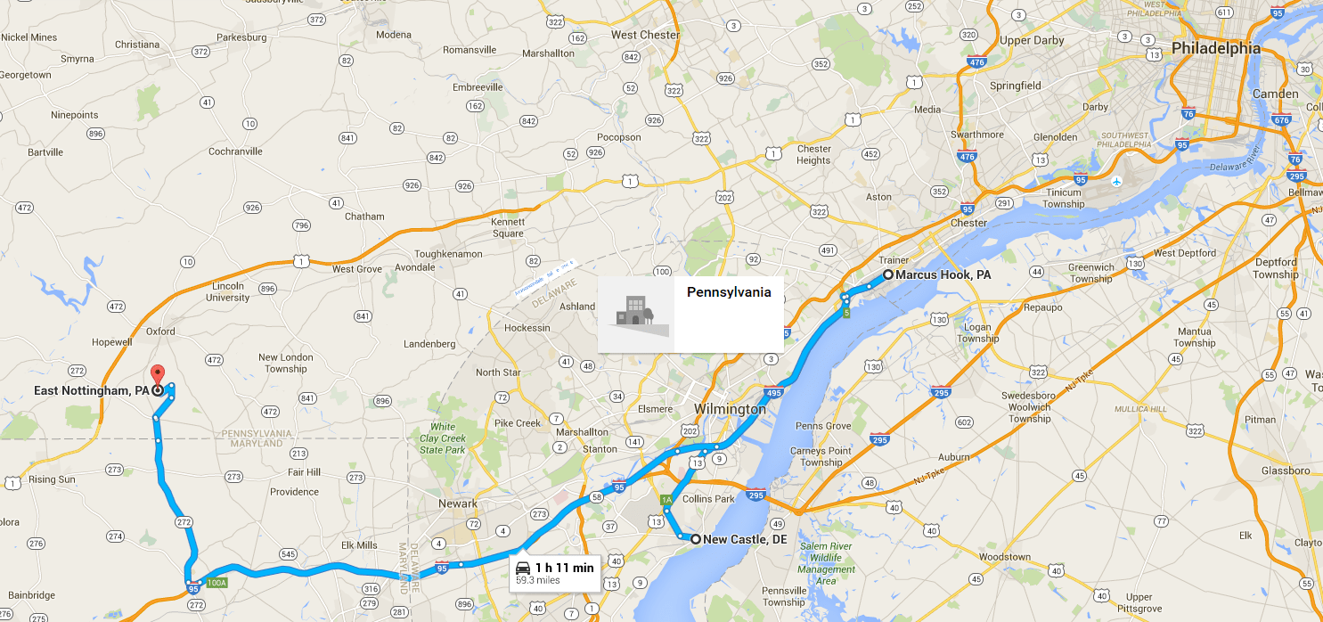
The Berkeley County family appears to have come from Ireland, based on a 1783 deposition recorded in Deed Book X, Vol 22, Page 335, Chester County, PA which records a statement by Mary Mercer, Berkeley County, VA, widow of Edward Mercer about sixty years old and a statement by Johathan Mercer, aged 50 regarding their acquaintance with a William Chapman. About two years after they left Ireland, the deponent (Mary Mercer) with others of her family, since dead, also left Ireland and came to America and found the George Chapman and William Chapman living on Delaware River near New Castle and Marcus Hook; they then lived together.

Delaware early map

Below is a current map showing Marcus Hook, New Castle and Chester County, PA.

Current Delaware map

If Mary was 60 in 1783, and was a child when immigrated, this would put her birth in 1723 and her immigration location sometime before marrying Edward (born in 1729) in New Castle and Marcus Hook.  So, this puts that Edward Mercer in the same vicinity or he would not have met and married Mary.  On the map, above, you can see that New Castle on the Delaware River is very close to Philadelphia, maybe 12 or 14 miles distant.

Philly to Winchester

My ancestor Edward Mercer (1704-1763), the elder, settled in Frederick County, Va, north on Winchester, by October 1744 when he first appears in the court minutes, serving on a jury.

A tradition says that he emigrated from Scotland in 1737 although that certainly has not been proven. Nothing is known about his early life, although after he arrived in Frederick County, by this time probably in his 40s or 50s, there are several references in court records.

Beginning in December 1754, Edward Mercer is sued by John Littler who owns land nearby.  In the same book, spanning 1754-1745, both Nicholas and Edward Mercer are sued by Jesse Pugh and both Nicholas and Edward serve on juries.  In the 1745-1748 Court Order book, we find Mercer versus Lemon and in Order Book 4, 1751-1753 we find Edward Mercer suing both James Dunn and Dugal Campbell, both dismissed by the parties.  In 1753-1754 we find Richard Mercer versus Poor and in 1754-1755, Edward Mercer vs Nathaniel Hare where Edward is awarded a judgment after Nathaniel fails to appear.  In 1755-158, we have Edward Mercer vs Hurman and in 1758-1760, Edward sues both Campbell and Lemon.  In 1760-1762, Richard Mercer sues Shibley and Simpson.  This looks like a lot, but is fairly typical for the timeframe.  Most suits were agreed upon and settled.

This branch of the Mercer family was found in Back Creek Valley during the 18th and 19th centuries. Edward Mercer died in 1763, and he named his wife Ann in his will, in addition to his children. A letter written by one Harrington in a letter to Wilmer Kerns on Oct. 27, 1993 states that Edward Mercer married Ann Croat (or Coats) in 1726, and he married second to Mary Gamble. However, we know that Edward was married to Ann when he died, based on his will, so this makes no sense.  Another rumor bites the dust.

Indian Traders

And yet another twist to this story.

In the “History of Scots/Irish,” Chapter 5, The Explorations and Early Settlers of West Virginia states that John Van Meter, a representative of an old Knickerbocker family early seated on the Hudson was an Indian trader. He made his headquarters with the Delawares and made journeys far to the south to trade with the Cherokees. In about 1725 he first told of the fertility of the Lower Shenandoah. In the section regarding the first white settlers of West Virginia in the area it goes on to say – “Among those that came about 1734 and settled along the Upper Potomac in what is now the northern part of the West Virginia counties of Berkeley and Jefferson included: Robert Harper (Harper’s Ferry), James Lemon, Richard Mercer, Edward Mercer, Jacob Van Meter.”

John Van Meter seems to have been headquartered in Kingston, Somerset County, New Jersey.   In an article relating to the last of the Southern Indians, which appeared in the Virginia Historical Magazine [Vol. III., p. 191, footnote], it states that “Mr. John Van Meter of New York gives an account of his accompanying the New York Delaware Indians in 1732 (?) on their raid against the Catawbas. They passed up the South Branch of the Potomac and he afterward settled his boys there.”

Robert Harper was born in Oxford Township near Philadelphia, Pa., in 1718. A builder and millwright, Harper was engaged by a group of Quakers in 1747 to erect a meeting house in the Shenandoah Valley near the present site of Winchester, Va.

In 1762, John Lemon obtains a land grant adjacent to both Nickolas and Edward Mercer.  From a transcription of the Virginia Northern Neck Land Grants, 1742-1775, Vol II:

John Lemon 1762 grant

In 1751, Edward Mercer obtained a land grant in Frederick County, Virginia for 275 acres adjoining Jacob Vanmeter. Does this suggest that our Edward Mercer arrived with that group of men?  And perhaps he was related to Richard Mercer?  Our Edward did name a son Richard.  The Edward Mercer of Berkeley County would only have been 12 years old in 1751, so this land grant has to be our Edward.

Richard Mercer’s wife name was Rebecca.  They sold land in 1764 on the Potomac that they had obtained from Josh Hite and Isaac and John VanMeter, the Indian trader family.

While it’s tempting to suggest that Edward Mercer in Berkeley County is the son of the older Edward Mercer (Sr.) of Frederick County, we show Edward Sr.’s son Edward Jr. in 1763 patenting land beside his father in Frederick County.

Edward Mercer Jr 1763 grant

Furthermore, Edward Mercer Jr. continued to live in Frederick County, years after the Edward in Berkeley County died.  We find in the Virginia Northern Neck Land Grants, 1775-1800, Vol. III:

Edward Mercer Jr 1788 land

Edward Mercer from Berkeley County, Virginia (now West Virginia) who died in 1783 shows the following people in the will index abstracts of West Virginia Wills and Probate records 1724-1978.

Edward Mercer 1783 death

Unfortunately, there is a lot of bleed through, but page 16 is the relevant page for Edward’s will.

Edward Mercer 1783 probate

Jonathan Mercer is clearly not Edward’s son, so perhaps he is Edward’s brother.  We know from the deposition that Jonathan was born in about 1733.

On November 13, 1752, we find that John Lemmon purchased property and the land deed was filed in Frederick County, VA. The description of the property includes 356 acres adjoining Edward Mercer, Nickolas Mercer, and Francis Lilborn.  A suit, Mercer vs Lemon, is found in the 1745-1748 court notes, but was impossible to find in the actual microfilm of the court minutes.  A Will for Nicholas Lemen is witnessed in 1761 by a Richard Mercer and his wife Mary.  This could be Edward Mercer Sr.’s son, Richard (who could have been in his 30s by this time), but who was Nickolas Mercer?

Nicholas Mercer is found in the road orders in 1746 and in 1748 he is replaced by Abraham Vanmetre, so he was clearly living in the same proximity as the VanMeter family which means he is connected to the Edward Mercer of Frederick County.  To be of age in 1746, he had to have been born in or before 1725, about the time our Edward Mercer would have been about 21 years old, IF he actually was born about 1704.

The Nicholas Mercer who was the son of Edward in Berkeley County could not have been of age in 1746 if Edward himself was only born in 1729.

Nicholas Mercer must have been connected to our Edward in some way.  In the December 1744 Frederick County Court session, we find the Jesse Pugh sued both Nicholas Mercer and Edward Mercer for trespass, in two adjacent transactions.  At that time, trespass typically didn’t mean walking on someone’s land, like today, but planting crops there.  Later, both Nicholas and Edward served on juries. Unfortunately, there is no Frederick County will for Nicholas, so we have no idea what happened to him.

Some people have drawn links between the various Mercer families that may not have existed in reality – drawing scattered references from multiple sources, including online trees, and weaving them together.

However, there are some very tantalizing clues that indeed, do need additional research.

George Washington and the Battle of Fort Necessity

We think of George Washington and his involvement in the Revolutionary War, but Washington’s involvement in the defense of Virginia began long before the Revolutionary War.  George was extremely involved in the French and Indian War as well.

The roster of men serving in the Fort Necessity Campaign of 1754 under George Washington is compiled from two rosters.

Edward Mercer appears.

Roster of Virginia Militia serving under George Washington during the Fort Necessity Campaign Officers – George Mercer, Captain (Lieut.); John Mercer, Lieutenant (Ensign); Wise Johnston, Corporal; Enlisted Men; Edward Mercer;

We know that Captain George Mercer is connected to the Irish/English John Francis Mercer family with no (known) relation to Edward.

Let’s look at what happened at Fort Necessity.  Edward Mercer was clearly there, so this is his story too.

The Battle of Fort Necessity (also called the Battle of the Great Meadows) took place on July 3, 1754, in what is now the mountaintop hamlet of Farmington in Fayette County, Pennsylvania. The engagement was one of the first battles of the French and Indian War and George Washington’s only military surrender.

Winchester to Fort Necessity

In March 1754, Governor Dinwiddie sent Washington back to the frontier with orders to “act on the [defensive], but in Case any Attempts are made to obstruct the Works or interrupt our [settlements] by any Persons whatsoever, You are to restrain all such Offenders, & in Case of resistance to make Prisoners of or kill & destroy them”. Historian Fred Anderson describes Dinwiddie’s instructions, which were issued without the knowledge or direction of the British government in London, as “an invitation to start a war”. Washington was ordered to gather as many supplies and paid volunteers as he could along the way. By the time he left for the frontier on April 2, he had gathered 1,867 men.  During the march to Pennsylvania, Washington picked up a few more men from a regiment they met at Winchester.  This would have been where Edward Mercer joined.

Washington along with about 150 Virginians built Fort Necessity on an alpine meadow west of the summit of a pass through the Allegheny Mountains on June 3rd.  Another pass nearby leads to Confluence, Pennsylvania; to the west, Nemacolin’s Trail begins its descent to Uniontown, Pennsylvania, and other parts of Fayette County along the relatively low altitudes of the Allegheny Plateau.

The fort was small, a circular stockade made of 7-foot-high (2.1 m) upright logs covered with bark and skins built around a little hut which contained ammunition and provisions such as rum and flour.  The palisade was built more to defend the supplies against Washington’s own men whom he described as “loose and idle,” than as a planned defense against a hostile enemy.

By June 9th, the rest of the Virginians had arrived.  Originally, the Delaware, Shawnee and Seneca supported the Virginians, but after a Native Council on June 18th, the Indians withdrew their support after the Battle of Jumonville Glen on May 28th in which Native leader Tanacharison killed French Joseph Jumonville personally.   Why the Native people withdrew their supposed is unclear.

Expecting to be attacked, and with word of the impending arrival of the French and Indians, Washington fell back, abandoning most of their provisions and supplies, and reached Fort Necessity by July 1st.

At Fort Necessity, the provision hut was depleted, and there was little shelter from the heavy rain that started to fall on the 2nd. With the rain, the trenches that Washington had ordered to be dug had turned into streams. Washington realized that he would have to defend against a frontal assault and also realized that it would be difficult because the woods were less than 100 yards away, within musket range, making it possible for a besieging attacker to pick off the defenders. To improve the defense, Washington ordered his men to cut trees down and to make them into makeshift breastworks.  The Virginians were clearly in trouble and they knew it.

As the British worked, the French led by Coulon, Jumonville’s half brother, approached Fort Necessity using the road the Virginians had built.  Coulon arrived at Jumonville’s Glen early on the morning of July 3. Horrified to find several scalped French bodies, he immediately ordered them to be buried.

By 11:00 am on the 3rd of July 1754, Louis Coulon de Villiers came within sight of Fort Necessity. At this time, the Virginians were digging a trench in the mud. The pickets fired their muskets and fell back to the fort, whereupon three columns of Canadian soldiers and Indians advanced downhill towards the fort. However, Coulon had miscalculated the location of the fort and had advanced with the fort at his right. As Coulon halted and then redeployed his troops, Washington began to prepare for an attack.

Coulon moved his troops into the woods, within easy musket range of the fort. Washington knew he had to dislodge the Canadians and Indians from that position, so he ordered an assault with his entire force across the open field. Seeing the assault coming, Coulon ordered his soldiers, led by Indians, to charge directly at Washington’s line. Washington ordered the men to hold their ground and fire a volley. Mackay’s regulars obeyed Washington’s command, and supported by two swivel cannons, they inflicted several casualties on the oncoming Indians. The Virginians, however, fled back to the fort, leaving Washington and the British regulars greatly outnumbered. Washington ordered a retreat back to the fort.  Washington must have been furious with the Virginia men who disobeyed his orders.

Coulon reformed his troops in the woods. The Canadians spread out around the clearing and kept up heavy fire on Fort Necessity. Washington ordered his troops to return fire, but they aimed too high, inflicting few casualties, and the swivel cannon fared no better. To add to the garrison’s troubles, heavy rain began to fall that afternoon, and Washington’s troops were unable to continue the firefight because their gunpowder was wet.

Louis Coulon de Villiers, who did not know when British reinforcements might arrive, sent an officer under a white flag to negotiate. Washington did not allow the Canadian officer into or near the fort, but sent two of his own men, including his translator Jacob Van Braam, to negotiate. As negotiations began, the Virginians, against Washington’s orders, broke into the fort’s liquor supply and got drunk. Gotta love those Virginia men.  They had their priorities.  If they were going to die, they didn’t want to leave the liquor behind!  Given what we discover about Edward Mercer later, there is little doubt that he was involved with this drunken escapade.

Coulon told Van Braam that all he wanted was the surrender of the garrison, and the Virginians could go back to Virginia. He warned, however, that if they did not surrender now, the Indians might storm the fort and scalp the entire garrison.

Van Braam brought this message to Washington, who agreed to these basic terms.

On July 4, Washington and his troops abandoned Fort Necessity. The garrison marched away with drums beating and flags flying, but the Indians and the French began to loot the garrison’s baggage on their way out, subsequently burning the fort.

Washington, who feared a bloodbath, did not try to stop the looting. The Indians continued to steal from the soldiers until July 5. Washington and his troops arrived back in eastern Virginia in mid-July. On the 17th, Washington delivered his report of the battles to Governor Dinwiddie, expecting a rebuke, but Washington instead received a vote of thanks from the House of Burgesses and Dinwiddie blamed the defeat not on Washington but on poor supply and the refusal of aid by the other colonies.

The battlefield is preserved at Fort Necessity National Battlefield, and includes a reconstruction of Fort Necessity.

Fort Necessity

“FortNecessityWithCannon” by Ikcerog – Own work. Licensed under CC BY-SA 3.0 via Commons – https://commons.wikimedia.org/wiki/File:FortNecessityWithCannon.jpg#/media/File:FortNecessityWithCannon.jpg

Voting in Frederick County

From Clark, Murtie June, Colonial Soldiers of the South, 1732-1774, Baltimore, MD: 1983: Pp. 328-332, in 1755, we know that both Richard Mercer and Edward Mercer Jr. are of age, because they both vote, as they do in 1758.  In 1761, both James and John Mercer vote for George Washington.  This puts the birth of both men before 1734, and possibly significantly before 1734.  At that time, and until 1762, according to Cartmell, voting for the House of Burgesses was reserved for men who owned land and significant assets, specifically, the gentry class.  In 1762, the voting rules were relaxed and allowed free men, of age, with only 50 acres of land or 25 acres with a house, or a lot in town with a house, to vote.

But the 1761 voting is interesting for yet another reason.  Colonel George Mercer is on the ballot for the election of Burgesses to represent Frederick County and Mercer Babb votes for him, as do both Edward Mercer Jr, Edward Sr., James, John, Moses, and Richard Mercer.  Col. George Mercer wins and represents the county in the House of Burgesses from 1761-1765.  George Mercer was born in Frederick County in 1733 to John Mercer, reportedly born in Dublin, Ireland, and Catherine Mason.  George was the brother to John Francis Mercer.

This tells us that Mercer Babb, whoever he was, was of age in 1761, so born in 1740 or earlier.  It also introduces the question – who is Mercer Babb?

To answer that question, we have to look at the Babb Family.

The Babbs

Thomas Babb was born in 1697 in Brandywine Hundred, New Castle, Delaware.  In 1730, he lived and was taxed in Bethel Township, Chester County, PA, according to the Hopewell Friend’s History.  He died on October 4, 1760 in Frederick County, Virginia. Not long after his marriage there was a movement of Quakers from Pennsylvania to Frederick County, Virginia. Thomas went with these Quakers and was one of the founding fathers of the Hopewell Monthly Meeting north of Winchester in Frederick County in 1734.

His father had a land grant of 600 acres on Apple Pie Ridge, near Babb’s Run, northwest of Winchester. Thomas settled there and was joined by his brother, Phillip. At his father’s death the two sons inherited his land.

Thomas Babb’s will was proved November 4, 1760. He left the home place to his son, Sampson, and other bequest to his other children. His wife, not being mentioned, is believed to have already died.

The first lovely old home belonging to Thomas was called “The Great Marsh Plantation“, now known as The Babb-Purcell-Janney House. It dates to 1735. Great Marsh is located on the north side of route 673 (Gold Hills Road) between route 522 and the Apple Pie Ridge Road in Frederick, Virginia.  On the map below, Babb’s Run is marked on Gold Hills Road with a small balloon just above the white box at the bottom of the map.

Great Marsh Plantation

The red balloon is James Crumley’s land, also on Apple Pie Ridge Road, about 6 miles distant from the Great Marsh Plantation.

The second home named “The Brick House” is a lovely old brick mansion and dates also to 1735. It is located west of the Apple Pie Ridge Road and south of route 672 on Babb’s Run. This is also in Frederick, Virginia.

The Brick House - Lupton Home

The Lupton family obtained the Babb land after Thomas’s death. The Lupton homestead was located just below Cedar Grove, about where the small gray balloon is located on the map below, according to a map from 1885.

Lupton home satellite

The Lupton homestead is located just south of Cedar Grove between Babb’s Run and the east side of North Mountain today, marked by the small balloon on the map above.  North Mountain is to the left of the balloon, with Cedar Grove Road on the other side of the mountain.

You can see and purchase these old maps at this link.

Referencing Jean Sargent’s Book “Babb Families of America” 3rd edition pg.113.

Philip Babb born in 1699 in Brandywine Hundred, New Castle, Delaware and died in Newark, New Castle Delaware on March 6, 1762, father of Thomas Babb who settled in Frederick County, Virginia, married Margaret Mercer.

This marriage would have had to have occurred after 1720, giving Mercer Babb plenty of time to be born between then and 1740.  This tells us that there were Mercers in this part of the world, likely related to Edward Mercer, and probably in New Castle, Delaware before 1740.

In the book, “The Babb Families of New England and Beyond, “ Jean Sargent on page 20 and 21 tells us the following about Thomas Babb:

In the Newark Monthly Meeting Records there is an entry dated 3 Oct 1713 which reads as follows: “Thomas Babb appearing at this meeting and gives ye meeting to understand yt ye death of his wife and for want of some person to whom he might leave ye care of his young children hath hitherto been ye lett of his not coming more frequent to ye meetings of business.” While there are early entries concerning Bathsheba, none of them mention the birth of her children or the date of her marriage. (7) Thomas prospered in DE and had sizeable land holdings as shown in the early land records. (4) In 1735 he received a Patent to 600 acres of land in Frederick Co., VA. By this time his three sons had moved to Chester Co., PA, just across the state line from their former home. Thomas sent the two younger sons Thomas, Jr., and Philip to occupy the 600 acres in VA and to carry out the other provisions of the Patent. (7) In his will, dated 17 Aug 1748 and proved 13 Aug 1751, Thomas bequeathed the home place in DE to his oldest son Peter, and left the VA lands to sons Thomas, Jr., and Philip. He made other bequests to his daughters Mary, Rebecca, and Lydia, as well as to three children of his deceased daughter Hulda — John, Rebecca and Lydia Gregory. (6)

In a 1758 election in Frederick Co., VA, among those voting for George Washington for the VA House of Burgesses were: Philip Babb, Thomas Babb (son of Phil.), Thos. Babb, Peter Babb, Joseph Babb, and Thos. Babb, Jr. (8)

Sources:

(1) “History of Town of Hampton, NH” by Dow; (2) Geneo. Diet, of Maine and New Hampshire by Noyes/Libby/ Davis; (3) “History of Salem, MA” by Perley; (4) DE Land Records; (5) VA Land Records; (6) New Castle Co., Probate Records; (7) Records of Robert E. Babb, Jr.; (8) Virginia Historical Magazine, 1899 p. 163.

So, once again, we circle back to Chester County, PA. about 1735-1740.

Margaret Mercer Babb was very probably Edward Mercer’s sister and named her son, Mercer Babb.

Backslidden Quaker

In Cartmell’s history book, he states that the area in Frederick County where Edward Mercer lived was known as the Quaker settlement, but several families lived there that were not Quakers.  He indicates that list includes the Mercers and Babbs who “had nothing to do with the Quakers.”  Cartmell was wrong.

Edward Mercer was a Quaker, but apparently a backslidden one.  So Edward may not have been a Quaker his whole life, and he may not have acted much like one when he was.

Edward was mentioned in the Quaker meeting records in March 1759 at the Baltimore meeting, but not in a very positive light.

Edward Mercer Hopewell

It looks like Philip Babb got to be the bearer of bad news.  Edward may well have been his brother-in-law, as this is the Philip Babb married to Margaret Mercer.

It seems like maybe Edward was systematically drinking too much.  In an economy driven by distilled liquors, as a form of money and a way to preserve corn, drinking “too much” must have meant truly drinking a lot by the standards of today.

Edward Mercer Hopewell2

Finally, Edward Mercer was removed.

Edward Mercer Hopwell 3

Was Edward Mercer being thrown out of the Quaker Church a family scandal?  Was his drinking a scandal?  What did his wife, Ann, do when this happened.  Did she and the children continue to attend the Hopewell Friend’s Meeting, or were they too embarrassed?  Or outraged?

Hopewell Meeting House

Road Orders

Edward may have been in trouble at church, but he was still quite functional as a road overseer – well – most of the time.

In 1759, the Frederick County road orders from August 7th order that a road be cleared between the plantations of William Reynolds and Thomas Babb Jr. and into Sr. John’s road in the same manner as heretofore and that the spring be left open to the said road and it is further ordered that Edward Mercer be overseer thereof and that the tithables a mile on each side of the road clear and keep the same in repair according to law.

On September 4th, the court ordered that Edward Mercer be overseer of Sr. John’s road from Winchester to the Plantation where Isaac Thomas did live and that the tithables three miles on each side of the said road keep the same in repair according to law.

By 1760, however, Edward was in a bit of trouble it seems.  On November 7th, the grand jury presents Edward Mercer for not opening the road from Capt. Pearis’s to Sir John’s Road at the Quaker Meeting by the knowledge of two of us at this present time.

On December 5th, the court notes that the summons had not been executed and refers it to the next court.

The next time we see Edward working on the roads in on May 4th, 1763, the same year he died.  Jacob Vanmetre, Morgan Morgan and Thomas Thornberry having been appointed to view the ground from the Town of Micklinbugh to the most convenient ford on Opeckon Creek made their report whereupon it is ordered that a road be opened as by them laid off and that the tithables three miles on each side thereof work under Edward Mercer who is appointed overseer of the same.

On November 2nd 1763, Thomas Babb is appointed as overseer of the road called Sir John Sinclaire’s road in room of Edward Mercer from the forks to James McGills.

Land

Edward Mercer received his first land grant in 1751 for 275 acres adjoining Jacob Van Meter as recorded in the Virginia Northern Neck Land Grants, 1742-1775, Vol. II.  Not a terribly descriptive land grant.

Edward Mercer 1751 land

Note that the entry shows that the adjacent entry was for Nicholas Mercer.

Edward Mercer 1751 grant

In 1759, Edward Mercer is shown on the rent roll for Frederick County as is Nicholas Mercer.

In 1760, Edward obtained a second grant, but this one is much more descriptive and is for 409 acres “near the head of Babbs Great Meadow and joyning Babbs Mountain”

Edward Mercer 1760 land

Fortunately, I was able to find Babb’s Mountain today, just above Cedar Grove.

Babb's Mountain

Philip Babb purchased property and the land deed was filed in Frederick County, VA. on 8 April 1760. The description of the property includes 117 acres adjoining Edward Mercer and on the side of Babbs Mountain. Source: Northern Neck Grants K, 1757-1762, p. 99.  The original survey reportedly exists.  Obtaining the original surveys of these lands would be most helpful in terms of exactly locating Edward Mercer’s land.

The Babb family has done extensive research on the land grants and has drawn the following map.

Babb land drawing

Based on the Babb map, the location of the Lupton home, and this survey from 1812, we know the location of Edward Mercer Jr.’s land, taken from the Virginia Northern Neck Land Grants, 1800-1862, Vol IV.

Lupton land 1814

Next, we find Edward Mercer Sr. leasing land to his son Moses, Bk 6 pg. 74 14 Oct. 1760: [Lease] between Edward Mercer & Ann his wife of County of Frederick [to] Moses Mercer of County aforesaid …… one tract of land lying and being under the mountain on the easternmost part of Back Creek and being part of a tract of land granted to said Edward Mercer by the Right Honorable Thomas Lord Fairfax by Patent the 18 April 1760… containing 200 acres and a half… Wit: 2 Wit. signed in German John Colson Recorded: 4 Nov. 1760 Signed by Edward Mercer & Ann Mercer

The easternmost part of Back Creek would be current Cattail Creek above Babb’s Mountain, or Babb’s Run, below Babb’s Mountain.

Richard Pearis purchased property and the land deed was filed in Frederick County, VA. on 18 May 1762. The description of the property includes 224 acres adjoining Jacob Vanmeter, and Edward Mercer. Source: Northern Neck Grants K, 1757-1762, p. 430 (Reel 294).

WEst land 1764

In 1764, the year after Edward died, his estate is still on the rent rolls, which is not unusual, especially if his wife is living there.  In addition to Edward Mercer, we find Edward Mercer Jr, Nicholas Mercer, Moses Mercer and Richard Mercer.

All of these men are sons of Edward, except Nicholas who appears consistently with Edward since 1746, before Edward actually appears in the County.  Was Nicholas Mercer Edward’s brother?

Edward’s Will

In 1762, Edward Mercer wrote his will, which was not probated in Frederick County until November 1, 1763, so he apparently lived another 14 months after making his will.  He was obviously ill, because in the will, he states that he is weak of body.

IN THE NAME OF GOD AMEN. The twentyth Day of September in the year of our Lord one thousand Seven hundred and Sixty Two, Edward Mercer of the County of Frederick in the colony of Virginia, being sick aged and weak of Body but of perfect and sound mind memory and understanding thanks be given unto God, therefore calling to mind ye mortality of my Body and knowing it is apointed for all men once to dye do make and ordain this my last Will and Testament that is to say principally and first of all I recommend my Soul into my saviour’s hands, and my body to the Earth to be buried in a Christianlike and Decent manner at the Discretion of my Executors hereafter named and as Touching what Temporal Estate it hath pleased God to Bless me with in this Life. I give devise and Dispose of the same in the following Manner and form Imprimis: it is my Will and I do order that in the first place all my just Debts by paid and satisfied.

Item I give and bequeath unto my son Richard Mercer one cow and calf and five shillings sterling. I give and Bequeath unto my Daughter Elizabeth Heath the sum of five shillings sterling.

I also give to my son Moses Mercer the sum of Five Shillings sterling.

I give and bequeath to my daughter Hannah Mercer five pounds and five shillings worth of Puter the same being now in her possession. And also one bed and furniture thereto belonging likewise I give to my said Daughter Hannah Six head of young cattle the same being now in her possession which said cattle shall be kept on the plantation until they be three years old. I also give her a side sadle and the Keeping of her mare on the plantation whilst she continues unmarried.

I give and bequeath unto my son Edward Mercer the plantation whereon I now Live containing two hundred and nine Acres and also a survey adjoining thereto containing Ninety six Acres of Land to him his Heirs and assigns forever. I also give to my said son Edward one bay mare and one bay colt plow and Tacklin thereto belonging. I also Will that if my above named son Edward Mercer should dye without issue that my youngest son Aaron Mercer shall then become sole heir of my Land and plantation whereon I now live and if both my said sons Edward and Aaron should die without issue, I will that my Daughter Hannah Mercer, become the sole owner of my above said Land and plantation, to her heirs and assigns forever.

I also will that my son Edward Mercer should pay as a Legacy to my youngest son Aaron Mercer the sum of Forty pounds and that within the space of four years after the said Aaron comes of age.

I also Will that my wife shall have the best Rooms in the new House now part built until my son Edward shall build her a compleat house on some part of the plantation at his proper cost which House shall be sixteen foot wide and Twenty foot Long. I also give to my wife Ann Mercer one third part of my parsonal Estate that may remain after the debts and Legacies mentioned are paid.

I will bequeath unto my son Aaron the two thirds of my parsonal Estate with the benefit and profit thereof Immediately after my decease which part of the said Aaron’s stock shall be maintained on the plantation until Aaron comes of age.

Lastly I constitute and ordain my well beloved wife Ann Mercer and my son Edward Mercer and Joseph Foset my sole Executors of this my Last Will and Testament revoking and declaring void all former wills and Testaments by me made and done in witness whereof I have hereunto set my hand and seal.

Signed Sealed and acknowledged by the said Edward Mercer to be his last will and testament in the presence us.

Jesse Pugh. Thos. Babb. Mercer Babb.

Edward Mercer. (LS.)

We know Edward could write, because he signed his name.

Edward Mercer will 1

Edward Mercer will 2

Edward Mercer will 3

Edward’s will was probated in Frederick County, Virginia on either November 1, 1763.

Edward Mercer probate will

Mercer Babb

Mercer Babb was clearly of age in 1762 when he witnessed Edward Mercer’s will, so was born in 1741 or before.  Generally, when someone witnesses a will, unless it’s a nuncupative will made in an emergency with death imminent, this indicates that the witness is not an heir, or they would not be witnessing the will.  Normally, those who witness wills have no direct interest in the outcome.  If Mercer Babb was born in 1741 or before, that means that either the Babbs and Mercers were together before they lived in Frederick County, they were both living in Frederick County by 1740 or there is a Mercer in the Babb family tree, because the name of Mercer Babb, especially witnessing the will of a Mercer male, is just not a coincidence.  Mercer Babb appears to be the son of Philip Babb and Margaret Mercer.  We know that Philip Babb was in Chester County by about 1735.  I do believe there is more to this story than we know and it all begins back in either Chester County, PA or before that in New Castle or Marcus Hook, Delaware.  These families appear to have come as a group from the Chester County area to Frederick County, VA.

Edward Mercer’s Estate Inventory (added 10-12-2015)

Recently, I spent an entire day in Richmond at the Library of Virginia, also known as the State Archives.  Like always, I prepared a research list.  While most of my research procured nothing, which isn’t unusual after you’re already plucked all the fruit you can readily see – I did come up with one big winner.

The estate inventory of Edward Mercer who died sometime between May 4th 1763 when he last appears in the Frederick County, Virginia court minutes in a road order, and November 1, 1763 when his estate was probated.  At that same court session, he was replaced as overseer or the road, so he apparently was still “working” up to a few months before he died, even though he prepared his will “being sick, aged and weak of body” in September of 1762.  Edward was probably just shy of 60, certainly not an old man – so his estate should reflect an active life, not a “retirement,” if there was such a thing then.

The first bingo I found in the library was a book of transcribed wills and estate inventories.  I was quite relieved because that meant I might not have to ask them to pull the microfilm and read that.  Old books on microfilm are not always legible nor is the indexing ever complete.  The only individuals indexed are the primary individual – not witnesses or wives or anyone else.  Many times the “rest of the story” is told in who surrounds individuals during their lifetime – so we need all of that additional information.

So, when I found Edward Mercer’s estate inventory listed in the transcribed book, I was ecstatic.  I read the estate inventory, and it was short and general.  It listed things like, “agricultural produce and farm animals.”  Well, I have to tell you, I’ve seen a lot of colonial wills and I have never seen one list something like that.  They list the produce and they list the animals, individually, or at least by breed.  In other words, you in far more danger of receiving far more information that you wanted than not enough, if an estate inventory was taken and filed.

It appeared that I was going to have to get the microfilm after all.

Estate inventories are a vastly overlooked source of information not available elsewhere.  The wills tell who your ancestors left his or her worldly goods to, but the estate inventory tells you what those goods were and those goods tell a huge story about your ancestor’s life.  In addition to what IS in the estate inventory, what ISN’T in the inventory tells a story too – especially in the context of the time and place in which they lived.

Many men did have a will.  Most wills were not written much in advance.  Sometimes wills were made verbally as the individual was on death’s doorstep to whomever was nearby.  These are called noncupative wills.  Sometimes, death was unexpected and there no opportunity for a will.

Most women did not have wills because most women did not own items outright, meaning outside of a marriage where the man was assumed to be the owner of the land (except for her dower rights.)  Often women retained what is known as a “life estate” where the woman holds either property or other items for the term of her life, at which point their ownership reverts to others, generally one or several children as specified in her husband’s will when he died.

If the woman dies before the man, the husband automatically owns everything so no will for the wife is necessary.  I’m talking about historical US wills, not current law.  I’m not a lawyer…I don’t play one on TV or anyplace else:)

Understanding how wills and ownership of both property and personal items worked helps in unraveling what estate inventories tell us.

When the man died, an inventory of everything was taken, even if the wife was to retain “household items.”  While that seems vastly unfair, especially since she often had to bid to buy her own cooking utensils back at a sale, it’s a huge boon for genealogists.

Sometimes individuals are mentioned in inventories – and in some cases, an item is left to a daughter in a will, but by the time she collects that item, she is married and a married name is listed.  In other cases, if something is left specifically to an individual, it is not included in the appraisal.  It doesn’t seem standardized, you say?  It’s not – and often it helps to look at other wills and estates from that county and time to observe what was customary.  Any deviation from custom must have been caused by something…and that something could be interesting to a genealogist.

Even the individuals who appraise your ancestor’s estate are important.  In Virginia, if your ancestor’s spouse was still living, one person who was from the “wife’s family” was chosen, keeping her interests in mind, the largest debtor of the person who died was selected, keeping their interests in mind, and one person completely disinterested in the outcome of the estate appraisal was selected.

With that information, you can sometimes add to your knowledge of the family, especially if you know the wife’s family is likely in the area.  How would you know that?  If your ancestor lived in that area when he married, his wife’s family would have been from that area too.  Young people often met at church or social functions – and with limited transportation – that social group wasn’t from any great distance.

People often married their neighbors or individuals from just a mile or two away.  Courting was likely done on foot, or maybe on horseback.  You can’t marry someone you can’t court!

So, let’s take a look at Edward Mercer’s will and see what is actually in the estate inventory.

The subscribers by virtue of an order of Frederick County Court being first sworn has met and appraised such of the estate of Edward Mercer, deceased, as was brought to our view by Ann Mercer and Joseph Fanset the executors – viz –

The values would be given in pounds, shillings and pence.

Edward Mercer estate 1

  • One old loom 0-15-0
  • Red Cow 0-15-0
  • 1 Cow and bell 3-0-0
  • 1 brindle cow 2-10-0
  • A brindle cow 2-0-0
  • A white cow 2-10-0
  • White back heifer 2-0-0
  • White bull 2-0-0
  • White heifer 1-15-0
  • Speckled heifer 2-0-0
  • Red yearling steer 1-0-0
  • White steer 1-7-0
  • White faced heifer 1-10-0
  • Brindle calfe 0-15-0
  • A pide yearling 1-0-0
  • A brindle yearling 1-0-0
  • Six calves 3-6-0
  • 2 pide steers 3-15-0
  • 2 heifers 2-10-0
  • One stear 2-10-0
  • A roan horse 6-0-0
  • An old mare 2-10-0
  • A mare and colt 3-10-0
  • A bay mare and colt 5-0-0
  • Old wagon and gears 9-0-0
  • A pen and gears 1-3-0

Edward Mercer estate 2

  • Eight swine 0-?-0
  • 2 sows and pigs 0-16-0
  • Harrow pens 0-10-0
  • Cart wheels 1-0-0
  • A rick of hay 3-0-0
  • 2 ricks of hay 6-10-0
  • Hay in the barn 2-0-0
  • Grain in the barn 12-0-0
  • Unbreak flax 0-5-0
  • 2 caskes and flax seed 0-9-0
  • Corn foder 0-10-0
  • Hay in the stable 0-15-0
  • A mall and wedges 0-5-0
  • 2 old axes 0-5-0
  • Indian corn 2-0-0
  • 2 old hoes 0-7-0
  • Small grind stone 0-3-0
  • An old gun 0-15-0
  • Another old gun 0-10-0
  • 2 bells and collar 0-5-0
  • Some old carpenters tools 0-14-0
  • Old iron 0-2-6
  • A pair of small hilliards 0-5-0
  • Few nails 0-2-0
  • Some more carpenters tools 0-10-0
  • An old saddle 1-5-0
  • Suit of cloathes 5-10-0
  • Side saddle 1-5-0
  • Old lumber 0-6-0
  • 8 old chairs 1-0-0
  • Old dough trough 0-3-0
  • A chaf (?) bed and cloaths 1-15-0
  • One bed and furniture 4-0-0
  • Seven old bags 0-7-0
  • Old casks and reel 0-5-0
  • Old chest 0-10-0
  • A morter 0-2-6
  • A warming pan 1-0-0
  • Old reeds and wifts (or mosts or wefts) 0-4-0

Edward Mercer estate 3

  • Some salt 0-6-6
  • Smoothing box and candlestick 0-3-0
  • Hand and gridirons 0-8-0
  • Iron poths (pots?) hangers and frying pan 1-3-0
  • Old books 0-6-0
  • Puter (pewter) 2-6-0
  • Some old tins 0-2-0
  • Sythes and hangings 0-14-0
  • Old copper 0-1-3
  • 3 old casks 0-5-6
  • 1 cask of cyder 1-4-1
  • 2 old whelbs(?) and branding iron and old tea kettle 0-11-0
  • Warping barrs and boxes 0-5-0
  • Hannah Mercers puter 5-0-0
  • Her bed and furniture 8-0-0

Jesse Pugh, Joseph Babb, Peter Babb

At court held for Frederick County the first day of May 1764.  This appraisement was returned and ordered to be recorded by the court.

The first thing this inventory tells us is that Edward Mercer was very involved in animal husbandry and likely only farmed enough to feed his animals.  He did not have plows and other typical farming implements and had many more animals than the typical farmer.

The entry for salt is interesting.  Salt was valuable because about 800 gallons of spring water had to be boiled away to yield a bushel of salt.  Today, we take salt very much for granted, but our pioneer forefathers certainly didn’t.

Edward’s family had chairs, not just a bench to sit on. And almost enough chairs for each person to sit at the same time.  He had 7 children, so the estate is one chair short for the entire family to sit together.  Perhaps one chair broke.  They are described as “old.”  However, there is no table listed.  That’s rather odd.

Edward was a good-hearted person.  He did not kill his old mare who was probably no longer useful.

Edward was likely a carpenter.  Every man on the frontier had a specialty skill, and his appears to be carpentry based on his tools.  This means that when you find homes built in that timeframe in that area, Edward may have worked on those.

Edward owned no slaves, but he clearly could have afforded slaves had he so chosen.  His lack of slaves then must have been either a personal moral judgment or a religious conviction.  However, other Quakers did own slaves including the family his daughter, Hannah, married into.

The flax and loom suggest that his wife and daughter spun and wove, although interestingly enough, a spinning wheel is not listed.  However, you can’t get from flax to weaving without spinning it into thread first.

There is cyder, but no alcohol.  There is no still.  This is highly ironic, since Edward Mercer was kicked out of the Quaker church in 1759 for…you guessed it….drinking.  In fact, “too frequently drinking strong drink to excess.”

Edward Mercer signed his will and owned books, so obviously this man could read and write.  How I’d love to know what those books were.

There is no Bible, although Edward was a Quaker up until he was kicked out of the church in 1759, ironically, for drinking, not attending meetings and not being penitent about either.

Other than Hannah’s furniture, which did include a bed, there were two other beds mentioned.  Was there a bed for the parents, then a boys bed and a girl’s bed?  There were two girls and five boys.

And speaking of Hannah, she is mentioned in the estate inventory, but it’s very likely that she was married by this time.  However, the fact that she is mentioned by her maiden name does not prove that Hannah was not married.  They may simply have referred to her as she was listed in the will. I have often wondered if she was already married when the will was written, even though Edward does not refer to Hannah by a married name.  The reason I question this is because Edward says that the “puter” (pewter) is already “in her possession.”  That would likely mean that she is not living at home, but unless she were married, where else would she be living?  Edward said the same thing about Hannah’s 6 heard of cattle as well, that they are already in her possession.  But then he goes on to say she can leave her mare on his plantation as long as she remains unmarried, so obviously she is not married at that time.  There must be something here that I’m missing.  Perhaps she was living with another family member before she married.

Edward does have two old guns, and he fought in the French and Indian War, so this makes sense.  These are likely the guns he carried with General George Washington at Fort Necessity.  What I wouldn’t give to see those guns.

And speaking of things I’d love to see…that old chest is one.  I want to open that chest and see what is inside.  I’m guessing that might be where Edward kept any spare clothes he had or anything of value – like maybe letters!!!

We also know that Edward’s wife, Ann, was living because she was one of the individuals who administered his will and “presented” his estate to the court.

We know that the family had candles.  The poorest families didn’t and worked only by the light of the sun.  Sundown meant bedtime.

In Edward’s case, either his estate was not sold at public auction, or there is no court record of the sale.  Many times, the sale is recorded, item by item, and who was present at the sale can tell you a huge amount.  In some cases, you can track valuable family heirlooms this way.

The moral of this story?  Don’t think you’ve found everything when you find your ancestors will, or even if you don’t find a will.  There is likely to be an estate appraisement with or without a will, and sometimes the information in the estate inventory tells you far more about your ancestors life and how they actually lived than the will itself.  Wills tell you who is supposed to get what, but estates tell you the story of your ancestors life through what they left behind.

If you look around your own house, you’ll realize that your sewing machine and quilting tools, for example, at my house, are far more personal and representative of what you do with your daily life than the land you own.

In terms of getting to know your ancestor, their stuff is far more important than their land.

Edward Mercer’s Children

  • Richard Mercer could have been the Richard who married a woman named Mary and lived in Berkeley County. John Mercer mentioned a brother Richard in his 1748 will that was filed in Winchester.  It’s difficult to tell when Richard first appears in the records because there is an earlier Richard that is found with Edward Mercer as well.
  • Elizabeth Mercer was born about (or after) 1724 and married by 1748 to William Heath who was born on Sept. 18, 1724. William was mentioned in the 1748 will of his brother-in-­law, John Mercer.
  • John Mercer was born circa 1727 and died in 1749, apparently unmarried. John lived in Frederick County, where his will is on file in the courthouse. His father, Edward Mercer, was named administrator for his estate.
  • Moses Mercer was of age and leasing land from his father by 1760. Moses was born in 1732 and died in 1805, in Frederick County. Appraisers of Moses’ estate were Jacob Rinker, Richard Barrett, and Thomas Babb. Moses married Dinah Morrison, who was called Dianna in his will. She was born Dec. 24, 1729, and died in April 1810. After Moses’ death in 1804, Dinah received all moveable property during her natural life, plus one-third of profits from real estate. She wrote her will on April 10, 1810 and it was probated June 7, 1810. Witnesses were Aaron and John Mercer, and John Barnard. Her close friend, Abraham Lewis was named the executor. Moses and Dianah signed their names with an X “His mark” and “Her mark,” respectively.
  • Hannah Mercer married William Crumley about 1763 and had died by 1774. Hannah was mentioned in the will of her brother John in 1748, and in the will of Elizabeth Morris in 1760. Who is Elizabeth Morris?
  • Edward Mercer was given “the plantation where I now live – 209 acres plus adjoining 96 acre survey” by his father. Edward was born about 1744. His age was proven from a deposition given in the Augusta County Circuit Court. The name of his spouse is not known.
  • Aaron Mercer, the youngest son, not of age in 1752 – served in Revolutionary War. On October 28, 1799 he obtained a Virginia Revolutionary War land grant in Ohio and moved to Ohio. Reportedly in his pension application (which is not at www.fold3.com as of 9-15-2015) he says he was born in Ireland. Aaron died on December 17, 1800 in Hamilton County, Ohio and is buried in the Old (Columbia) Baptist Graveyard. Given that there were no Revolutionary War pensions before 1818, there would have been no pension application by him, although if his wife, Elizabeth Carr, was still living, she could have applied in either 1818 as destitute or 1832/33 as a surviving veteran’s wife. She is reported to have died in 1820, so I’m quite suspicious of the claim that his Revolutionary War pension paperwork stated that he was born in Ireland.

Speculative Family

Based on all of the pieces of evidence, it looks like a speculative family might include our Edward, born about 1700, a brother Richard found with Edward early in the records, a brother Nicholas found in 1746, and a sister Margaret who married Phillip Babb sometime between 1720 and 1740.

The identity of the Edward Mercer born in 1729 who lived in Berkeley County is unclear, but given the names of Edward, Richard and Nicholas, and the locations of Chester County, PA and Delaware, these lines do seem very connected.

Edward in Berkeley County could be the son of either Edward Sr.’s brother Richard or Nicholas – although this does beg the question of what happened to either Richard or Nicholas.  Richard could also have been Edward Mercer Sr.’s eldest son, not a brother.  If that is the case, then Edward born in 1829 cannot be the son of Richard Mercer.

The tidbits we do have also support the suggestion that this family may have immigrated from Ireland before 1740.

However, this is speculative and needs additional research before any conclusions can be drawn.  I suspect the answer is either in Chester County, PA, Marcus Hook, PA or in what is now New Castle, Delaware, if the answer exists anyplace.

DNA

The DNA results having to do with this line are every bit as frustrating and elusive as the genealogy has proven to be.

I checked the Mercer DNA project and was extremely happy to discover a Y DNA project member that indicated that they descended from Edward Mercer born in 1704, the birth year typically attributed to our Edward.

Home run!

Except…

Doggone it, there’s another tester who gives his ancestor as Edward born in 1705.  That’s just too close.  Worse yet, their DNA doesn’t match.  Clearly two independent lines.

So, I checked at YSearch.  No account for Mr. 1705 and the 1704 account had no marker values entered but it did include the death year of 1763, which pretty well cinches the identity as our Edward.  I tried to contact the individual through YSearch, with no luck.  This is a low kit number, indicating an early tester so the tester’s e-mail may be stale of they may not be able to reply anymore.

Next, I wrote to the project administrators of the Mercer project and asked them if they have the oldest ancestor information for either or both testers, or if they would please facilitate contact with those men.  Nothing, nada, silence from the admins.

Doggone!

There is just nothing worse than a desperate genealogist.

Mercer Y DNA Project

(Click on image to see larger version.)

I copy pasted the relevant Mercer project entries into a spreadsheet.  They weren’t grouped on the Mercer DNA site, so I grouped them compared to the entry for kit number 94427 which I believe is our Edward Mercer (c1704-1763).  The yellow cells are mismatches to kit 94427.

There is only one other Mercer that even matches remotely, kit number 99939 just above the lower pink 94427 with the green row.

There is an entire group of blue Mercers that fall together nicely.  However, in this blue group we find kit number 84471 also pink), the other Edward Mercer born in 1705.  This entire line reportedly tracks back to guess where… Chester County, PA with Robert born in 1741 and Elizabeth Brown Mercer.

I checked Chester County tax records, and there are several Mercer men living there in this timeframe.  They may or may not have been related to each other.  And none were named Edward, Richard or Nicholas.  Pulling hair out now….

Finding this large blue group associated with Chester County, and my lonely Edward Mercer with only one distant DNA match is beginning to make me very nervous.

This makes me ask questions like:

  • Was Edward Mercer who died in 1763 “supposed” to be paternally related to the Chester County group, but wasn’t?
  • Is there a NPE (nonpaternal event or undocumented adoption) in the lines of one of Edward Mercer’s sons, but not the other one, causing one descendant to match the Chester County group, and one descendant to not match the group?
  • Is someone’s genealogy wrong?  And if so, which one?  I’d just be happy at this point to actually see the genealogy of either tester, and preferably both.
  • Why aren’t the project administrators answering inquiries about the project?  Are they gone too?

It’s small consolation, I know, but at least the two “Edward” kits are both haplogroup R-M269.  So, assuming (I hate that word, BTW) either of these men descend from my Edward Mercer, I at least know that much.  But at the 50% frequency rate in Europe of M269, that would have been a safe bet with no DNA testing at all.

Needless to say, if you are a male Mercer who descends from Edward Mercer who died in Frederick County in 1763, I have a DNA testing scholarship for you!

______________________________________________________________

Disclosure

I receive a small contribution when you click on some of the links to vendors in my articles. This does NOT increase the price you pay but helps me to keep the lights on and this informational blog free for everyone. Please click on the links in the articles or to the vendors below if you are purchasing products or DNA testing.

Thank you so much.

DNA Purchases and Free Transfers

Genealogy Services

Genealogy Research

Crumley Kinfolk

Just for fun, let’s look at some Crumley folks who are related.  When you work in the genetic genealogy field, people are forever sending photos of someone and saying “doesn’t this person look like that person?  Do you think they are related?”  Or, the most common, “this is my great grandmother – do you think she looks Native American.”

I am forever telling people that phenotypical resemblances are really not good indicators of relatedness, but it’s so difficult to believe when you’re looking for that needle in the haystack and it’s the only tidbit you have.

I did it myself when I found Lee Devine and discovered that not only was he deceased, but he had no children, so my chances of ever finding out definitively if he was my half brother are forever gone.  I reverted to picture comparisons, because it’s the only tool I had at my disposal.

So, let’s have some fun with this.

Take a look at this photo.  These men are unquestionably related.  The question is, how closely?

crumley kin

So, how do you think they are related?

If you said brothers, you’re in good company.  They look like brothers, but they aren’t.

If you said uncle and nephews, you too would be in good company, but nada.

Cousins maybe?

Well, yes.

These are all Crumley men, left to right, John, Ken, Jerry… and Donna, the daughter of one the men whose job it was to keep them in line that day.  Fortunately for Donna, she doesn’t have the signature family beard!

Years ago, the Y DNA tests through the Crumley DNA project confirmed that these men share a common Crumley ancestor, but despite appearances, they are much more distantly related than you might think.

Not first cousins.

Not second.

Not third.

Not fourth.

Not kidding!

The common ancestor of these men is John Crumley, born about 1737.

Yes, I know how much alike they look, but looks can be deceiving – or encouraging – and looks are not an accurate predictor of relatedness.

John and Ken are 4th cousins once removed.

Ken and Jerry are 5th cousins.

John and Jerry are 5th cousins once removed.

Their pedigree chart is shown below.

Crumley kin pedigree

Not quite what you would expect by looking at the picture.  As someone once said to me, “If you look at a picture long enough and hard enough, you can see anything that you want to see.”  Touche!

The Crumley DNA project at Family Tree DNA has embraced autosomal DNA testing, so all three of these gentlemen have taken the Family Finder test.  Knowing that their Y DNA matches (with a mutation or two), and having identified their common ancestor, let’s see if their autosomal DNA matches as well.

At Family Tree DNA, one must meet a 20 cM total DNA matching threshold, and an individual matching segment threshold of 7cM in order to be listed as a match.  Here’s how they matched, or didn’t.

Jerry John Ken
Jerry Self Yes No
John Yes Self No
Ken No No Self

Needless to say, if we didn’t already have the Crumley Y DNA results, this might have given Ken a bit of heartburn – but no need.  It’s not uncommon for distant cousins to not be shown as matches.

Fortunately, all three gentlemen also downloaded their results to GedMatch, where we can adjust the matching threshold.  In some cases, the 20cM total precludes a match, and in some cases, the 7cM segment precludes a match, so let’s see if these gentlemen match at GedMatch using a lower threshold.

At GedMatch, I ran all 3 gentlemen against each other using the threshold of 300 SNPs and 3 cM and then put their results into a common spreadsheet.  I also deleted the duplicate entries, because for every Ken to John match, there is also an identical John to Ken match.

You can see on the spreadsheet below that John and Jerry match each other, just as Family Tree DNA said.  They share not one, but two large matching segments of over 16 cM.  Not bad for 5th cousins once removed.

Crumley kin gedmatch

You can also see that Ken matches both Jerry and John, but not on any segment over 4.9 cM, which precludes matching at Family Tree DNA.  However, Ken exceeded the 20 cM total match threshold with both Jerry, at 51 cM and John at 35.8 cM – but a match has to exceed both thresholds to be counted as such.

Especially within known family groupings, a non-match doesn’t necessarily mean the individuals don’t share any DNA, it may just mean that there isn’t enough cumulatively (>20 cM) or the segments are too small to put them over the threshold (7 cM).  That’s the great thing about GedMatch, you can adjust your own thresholds.

Are all of these segments valid, meaning are they identical by descent?  Most likely not.  Are some valid?  Very probably, especially given that we know that these men unquestionably do share a common ancestor – thanks to their Y DNA.  Could we find out more?  Yes, we can, if we have more cousins to compare against.

And, as luck would have it, we do, another 40 or so….but that story will have to wait until the Crumley DNA Study is ready for publication!

Thanks to Ken, Larry and John, my Crumley kin, for DNA testing and allowing us to tell their story and share their picture.  You can see by the smiles on their faces that they are truly enjoying their kinship – and that is really what matters.  Genealogy and genetic genealogy has the ability to reunite families separated by more than 200 years and 6 or 7 generations – and that’s exactly what has happened with our Crumley kin.

______________________________________________________________

Disclosure

I receive a small contribution when you click on some of the links to vendors in my articles. This does NOT increase the price you pay but helps me to keep the lights on and this informational blog free for everyone. Please click on the links in the articles or to the vendors below if you are purchasing products or DNA testing.

Thank you so much.

DNA Purchases and Free Transfers

Genealogy Services

Genealogy Research

William Crumley the First (c1735 – 1793), Originally a Quaker, 52 Ancestors #87

The Crumley Conundrum…that’s what this line of genealogy has been called for years by researchers.  The current generation of researchers named it, but I’m sure all past Crumley researchers would confirm that name with a hearty “hear, hear” or maybe a different line would just say “Amen.”

The Crumley family, due to common first names, large families, wives with no names at all, or no surnames, and often common first names, intermarrying into the same families generation after generation….is a mess.  This has been one of the most difficult unraveling challenges I’ve ever seen…and I don’t pretend to tell you that I have this exactly right.  What I am doing is sharing what I do have documented with the hope that someday, other researchers will be able to add to this research.

I’m fortunate that I do have the benefit of a few pathblazing researchers who came before me…and those are the ones who did share their information before they died or dropped off of the face of the earth.  I swear on everything that is Holy that I will NOT let that happen to my genealogy and my ancestors.

William Crumley, the first, was born in 1735 or 1736 in East Nottingham Township, Chester County, PA to James Crumley and Catharine Gilkey.

Chester County PA map

East Nottingham is in the southwest corner of Chester County which borders Cecil County, Maryland.  They is a very interesting history to this region, but you’ll have to wait for the James Crumley article to read about that!

Frederick County, Virginia

When William was a teenager, his family moved to Frederick County, Virginia, in present day Berkeley Co., West Virginia on the border, literally, between those two states.  Of course, West Virginia didn’t yet exist at that time.

James Crumley land spanning border

This drive from Gerrardstown in Berkeley County, West Virginia to Apple Pie Ridge in Frederick County, Virginia runs along Mill Creek and cuts right through the middle of James Crumley’s land.

James Crumley, William’s father, bought the survey rights to a tract of land totaling 742 acres on Sept. 6, 1753 from James Anderson and on February 1, 1754, the land was granted to James Crumley.  William would have been about 17 or 18 at this time, and certainly of an age to be a big help on the farm.  At this time, that probably meant felling trees, so William was likely to be a very muscular lad.

James Crumley land survey

We are fortunate that the Berkeley County Historical Society published a wonderful article in Issue 8 of the Berkeley Journal titled “Houses and Historic Sites Locates on the James Crumley Land Grant.”  This journal, published in 1979, is still available for purchase through the Historical Society.  All of the plat and survey information is from that article.

In February 1757, William acquired from his father 270 acres at the southern end of the Lord Fairfax tract, in what is now Berkeley County, West Virginia.

James Crumley land divided

One of the Crumley cousins who has visited the site was kind enough to send this map as well.

James Crumley land map

It was also in 1757 that William’s father, James, wrote his will.  Perhaps James was getting his affairs in order.

Frederick County Deed Book 4, page 229, recorded on March 1, 1757:

On February 28, 1757, this indenture between James Crumley (spelled Cromley throughout) and William Crumley (spelled Cromley throughout) both of Frederick County, for 2 shillings current money of Virginia, Frederick County tract of 270 acres…Thomas Martin corner…foot of a ridge…along Martin’s line…crossing Mill Creek…part of 742 acres granted to James Crumley by deed from the proprietors office bearing the date of first of February MDCCLIV (1754).  William Crumley to pay the rent of one ear of Indian corn on Lady Day next.  Signed by James Crumley his mark and witnessed by Thomas Wood, Edmond Cullen and William Dillon

This deed is registered with the court and followed by a similar deed which seems to release William from a one year indenture.

March 1, 1757 James Crumley to William Crumley for 22 shillings…release and confirm unto the said William Crumley (in his actual possession now being by virtue of a bargain and sale to him hereof made for one year indenture bearing date the day next before the date of these presents and force of the statute for transferring uses into posessions)…tract or parcel containing 270 acres.

Today that land is located on Greenspring Road near the Frederick County line on the most southern section of the James Crumley land grant.

The description is exactly as the first document as are the witnesses and it is filed on the same day, March 1st, 1757.

James Crumley home

Today, this map shows the location of the original James Crumley home at 3641 Apple Pie Ridge Road.  It was placed on the National Register of Historic places in 2006 as the Crumley-Lynn-Lodge House in Frederick County, VA.

James Crumley Apple Pie Ridge

The Hopewell Meeting house (shown below) lay southeast of James property, and William’s land lay north, just over or straddling the border between Virginia and West Virginia today.

James Crumley Hopewell

You can see Mill Creek, shown on James’s original grant, running parallel with 51.2 in West Virginia today, south of Gerrardstown.

James Crumley road along Mill Creek

Religion and Politics

William Crumley, along with his father and siblings were residents of Frederick County when George Washington won his first elective office as a Frederick County delegate to the Virginia House of Burgesses in July, 1758, so it possible that the two may have had some contact. Washington, however, did not actually live in Frederick County and did very little campaigning there, other than to buy plenty of liquor for the voters.  Voting was a bit different then.

Quaker men were supposed to abstain from drinking alcohol, but that did not seem to apply to our Crumley men, judging from the contents of their estates.

George Washington kept a diary.  It seems he endorsed that old saying about holding your friends close, but holding your enemies closer.  At least, he wanted to know who was on his side, and who was not.

At that time, voting was not private like it is today.  One had to declare publicly who you were voting for.  Voters were allowed to vote for two candidates.

After Washington received the Frederick County polling results, he made an alphabetic list of all the voters and their publicly proclaimed choices. James Crumley and his sons John and William voted for Hugh West. John and William also voted for Colonel Washington, but James, their father, cast only the one vote.   In addition to his voting preference, this also confirms that William was at least 21 years of age by this time.

Like his father, William was a member of the Parish vestry, serving in 1759. Although the Vestry was actually under the jurisdiction of the official Episcopal Church, it had political functions as well, and it was not unusual for Quakers to be members.

Henings Statutes shows that in November of 1769, William was indeed a vestryman.  He and his fellow vestrymen were authorized to levy taxes on the residents to pay for the outcome of a suit wherein a former minister sued for back pay. Chapter LV, page 416:

WHEREAS William Meldrum, clerk, late minister of the parish of Frederick, in the county of Frederick, by judgment of the honourable the general court, hath recovered against John Hite, John Greenfield, John Bowman, Thomas Speake, John Lindsay, William Cocks, Robert Lemen, William Crumley, Cornelius Riddell, Isaac Hite, Thomas Swearingen, and John Funk, gentlemen, late vestrymen of the said parish, the sum of one hundred and forty-nine pounds twelve shillings and one penny, for the balance of his salary as their minister; and also three pounds and nine pence, and four thousand six hundred and fifty-five pounds of tobacco, for costs; and whereas the said vestry were also at some charges in their defence; and it appearing to this present general assembly, that it is reasonable that the said vestry, or such of them as have actually paid the said judgment, costs, and charges, should be reimbursed the same, and such commissions as they, or any of them, may have paid for having the same levied on them: Be it enacted, by the Governor, Council, and Burgesses, of this present General Assembly, and it is hereby enacted, by the authority of the same, That the present vestry of the said parish shall and may, and they are hereby authorized and required to levy and assess, upon the tithable persons within their parish, the amount of such judgment, costs, charges, and commissions…

William Crumley was married in about 1761 to Hannah Mercer, daughter of Edward Mercer and his wife Ann.

The Hopewell Church (VA) history book (671 pages) mentions James Crumley, father of William (the first), but William is never mentioned in the book.  William (the first), we know, was also a Vestrymen of the Anglican church, but this is known only from the Laws of Virginia.  It seems strange that no mention is made of William’s “disownment by reason of marriage outside the Quaker faith”, a very common practice in those early years, if in fact he married outside the faith.  If he married within the faith, then his son, William (the second) split with the church at some point, because by 1797, William (the second) was a founder of a Methodist Church in Greene County, TN.

William’s Father Dies

In 1764, William’s father, James died and his will was probated.  William was one of several children mentioned.

In 1773, William, his brother Henry, and their niece Ruth (Doster) Noland through husband Thomas Noland sold 200 acres at the southern end of the Lord Fairfax tract in 1773 to Thomas Faulkner, who had married Jane Dunn, William’s mother-in-law.

Deed Book 2, page 149.

“Two hundred acres being part of a large tract containing 744 acres granted to James Crumwell (sic) decd from the proprietor of the Northern Neck…the said William Crumley, Henry Crumley and Thomas Nolan to Thomas Faulkner.  Hannah William’s wife, Ruth Thomas Nolan’s wife and Sarah Henry’s wife…William Crumley is attorney in fact for Henry Crumley.  One hundred sixty pounds and 8 shillings.  Dated Aug 18, 1773 (I can’t tell if is the date of the deed or of the poa following.  I believe it is the deed.)

Signed
William Crumley
Hannah Crumley
Henry Crumley
Thomas Noland
Ruth Noland

Witnesses
William Boyd
Joseph Kile
John Ridgeway
John Tryall?

William’s Wife Dies

In about 1773, William’s wife, Hannah, died.  William and Hannah had 5 children that lived to adulthood.  If they were married in 1761, they likely had at least 6 children, and possibly 7.  It appears that they lost at least one child.

After Hannah’s death around 1773, William married Sarah Dunn, daughter of James and Jane Dunn and step-daughter of Thomas Faulkner, whom, we know is a neighbor because William sold part of James land to Thomas Faulkner.  So William married the neighbor’s daughter.

We know by this time that William was not active in the Quaker church, because in 1774 after his marriage to Sarah, the Hopewell Friends disowned her for marrying “contrary to discipline.”  Obviously, Sarah had to know that would happen before she married William, and didn’t care.

The Revolutionary War

When William was about 45 years old, the Revolutionary War became a reality in Virginia.

In 1781, William was among the Berkeley County citizens who provided supplies for the use of the Revolutionary armies. One certificate (receipt) dated September 30, 1781 indicated that he and three others, including his wife’s brother William Dunn and her stepfather Thomas Faulkner were generously entitled to 225 pounds for just eleven bushels and a peck of wheat.

The only record of William actually receiving reimbursement was a June 1782 Publick Service Claim, recorded in the Berkeley County court order book, in which he was “allowed 5 pounds for eight days in actual service as a receiver in Collecting the cloathing and provisions for the use of the state.  This “patriotic service” has qualified at least two of his descendants for membership in the Daughters of the American Revolution.

Oral history of wars and service therein, especially if you are on the “right” side tends to be one of the tidbits passed along within families.

Portrait and Biography Album, Jefferson Co., IA, (1890), 188, Sketch of Isaaac H. Crumly, Sec. 9, Penn Township:

Born in East Tennessee Dec 24, 1820 and traces his ancestry back to early Colonial days when his great-grandfather, William Crumly, resided in Virginia. Large slave-holder and served in the Revolution. His son William was a farmer and removed to Tennessee when that country was first settled.  His son Abraham was born in Greene Co., Tenn. in 1787…Abraham Crumly, father of Isaac H. married Elizabeth Marshall, born 25 June 1796, dau. of Abram and Martha (Doane) Marshall; she died 29 Mar 1827. Abraham married, 2nd, Jane McNees, who died 8-18-1845.

William (the first) had at least 15 children in total, who are listed in his will as recorded in Berkeley County, then Virginia, now West Virginia, Will Book 2 page 185-187.

William’s Death

William died in Berkeley County between September of 1792 and September of 1793, most likely in the summer of 1793 or his will would have been probated earlier in the year.  He had gotten his crops planted before he died, because his inventory includes a field of corn.

In William’s will he wrote:

“…My plantation I purchased from my brother John to be sold by my executors to my best advantage, payments to be made but the land not given up to the purchaser until March 26, 1795 which is the expiration of John Antraus lease.  When my executors receive the whole of the purchase money they are to give each of my children that is come of age the sum of 10 pounds.  I leave to my loving wife Sarah Crumley all the rest and the remainder of my estate both real and personal for life or whist she remains my widow.  My widdow Sarah Crumly shall Rays my children together to give them learning out of the profits that arises from my Estate the boys to read write and cifer The Girls to read and write.”

If Sarah remarries, the entire estate is to be sold and after deducting for “raising and schooling my young children” the estate is to be equally divided among my 15 children after adding? to each what they have already received namely James, Ann, William, Catherine, Aaron, Jane, Thomas, Sarah, Henry, Mary, Stephen, Elizabeth, John, Martha and Rebecca.  If any of the children die, the balance to be divided among the remaining children.  If Sarah remains a widow until her death, the estate to be divided the same way.  Good friend David Faulkner and wife Sarah Crumley executors.  Dated Sept. 30, 1792

Witnesses:
William Wilson
Tom Doster
John Watson Sr.
Jesse Rubell (Ruble)

William Crumley died between the date his will was filed in Berkeley County, Virginia, 30 September 1792, and the date it was proved, 17 September 1793, age about 58.  He was not an old man, at least not by today’s standards.  Given that he made his will almost a year before he died, he clearly had advance warning that something was amiss.

I find it interesting that the boys were to be taught to “read, write and cipher,” but the girls only to read and write.  I guess they didn’t need to know how to cipher back then, or at least William didn’t think they did.

The fact that William’s will was probated in Berkeley County tells us that he was living on the land from the James Crumley land grants, not the land his father owned in Frederick County on Apple Pie Ridge.

Houses on the Crumley Land

The journal article tell us that after Sarah’s death in 1809, David Faulker, William’s executor, then living in Greene Co., Ohio, sold William’s plantation of 270 acres for $6000 to Aaron M. Crumley and Thomas Crumley (Superior Court Deed book 20, page 47).  A year later, the brothers sold the land for $4468.33 to Abraham Waidman of Berk’s County, PA (DB 27, p 241).  It sure makes me wonder why they were willing to take a significant hit of about 1/3 of the land’s value in just a year.  Frances Silver then acquired the land, some before 1820 and some after.  Between 1820 and 1821, according to tax records, he build a large, by the standards of those days, brick house which was still standing when the journal article was written.

James Crumley Francis Silver Houe

The home that William would have lived in likely looked much more like a log cabin, and probably was a log cabin.  This cabin, below, was built on the middle section of James land.  William was assuredly in and out of this cabin regularly, as Thomas Faulkner was his second wife’s step-father.

James Crumley Faulkner cabin

The journal article tells us that Thomas Faulkner built a log cabin on this land in 1775 with a wing added about 1785 that was still standing in 1979 when the article was written.

James Crumley Hodgson cabin

William Crumley Homestead

I was able to find William Crumley’s land on an 1890 map by following the ownership of the Silver land, as stated below.

Francis Silver acquired the Crumley land in two tracts. The first tract of 62 acres before 1820. He built the beautiful brick house in 1821. The 1820 land book lists no house. The 1822 lists $1,000.00 added for improvements added last year. He purchased the larger tract from Abraham Waidman in 1829 (DB lost). In 1836 Francis Silver sold the brick house with 275¾ acres to his son Zephaniah Silver who had married Martha Jane Henshaw April 17, 1834. They kept the plantation until after the Civil War and sold in 1868 for $12,000.00 to John Hershey. John Hershey sold the house with 197 acres for $5,000.00 to Andrew B. Houck and Samuel Garver. May 1, 1876 (DB 73, p. 275). Samuel Garver and A. B. Houck sold in 1880 to J. R. Brown and Robert M. Brown (DB 77, p. 119, page 259). Joseph R. Brown sold his half interest to Robert M. Brown in 1885, who sold the same year to Charles G. Boyles and James K. Boyles for $8,100.00. Charles G. Boyles sold his half interest to James K. Boyles in 1919. James K. Boyles died in 1932 leaving all his estate to be divide equally between his children (WB 27, p. 386). Daughter Maggie R. Busey died in 1951. The heirs of James K. Boyles sold to James A. Lockard in 1959 who gave a Deed of Trust to Darrell K. Koonce. In 1962 . . .

On the following map, you can see the location of J. Boyles land at what looks like the headwaters of Mill Creek, just north of the border of Berkeley County and Frederick County, on the road that today leads to Gerrardsville.  You can also see North Mountain to the left.

Berkeley county 1890

On these satellite views, you can see the same road today.  The house on the map above is about half way between the dog leg in the road north of the house and the state line ot the south, between the creek and the road.

On the map view of the area, you can see the same dog leg in the road and today, there is  Mt. Pleasant Cemetery, shown in green, across from this area.

William Crumley land map

Moving to the satellite map, you can see the farms in that location today.

William Crumley land satellite

Moving a little closer.

William Crumley land satellite 2

Moving even closer you can see that there is a working farm in this location.

William Crumley land satellite 3

Unfortunately, there is no street view of this area.  The address of this property today is 3647 Dominion Road.

William Crumley farm today

This looks like the original structure.

William Crumley farm home

So, mapping the way from William Crumley’s house to his father’s house on Apple Pie Ridge looks like this.

William Crumley to James Crumley

Visiting William Crumley’s Property (added October 2015)

A speaking engagement in Richmond in the fall of 2015 provided me with the opportunity to visit Apple Pie Ridge in Frederick County, Virginia and the area of Berkeley County, West Virginia that adjoins Frederick County.  William’s father, James Crumley lived on Apple Pie Ridge Road and left sons John and William land a few miles north of his home location.

William Crumley 1c

This path from Apple Pie Ridge Road up the valley to Gerrardstown is the natural path that was once an Indian trail, then a wagon road.  Today, it’s lined with apple trees and orchards, heavy with ripe apples.

William Crumley 2

From Apple Pie Ridge Road, going north, you turn on Winding Hill, then north on Frog Hollow Road which becomes Dominion Road when you cross the state line.  Winding Hill does just that, winds down the hill.

William Crumley 3

The ridge of mountains is forever to the west, standing as a marker that was once the barrier to westward expansion.  This path was the path that the French and Indians took in 1754 to raid the valley and attack the settlers from Gerrardstown to Winchester, and south.  The Europeans weren’t the first to discover that this was the natural pathway along the mountain ridge.

William Crumley’s property spans the state line, with most, including the house being on the West Virginia side.

William Crumley 4

Today, much of the land is cleared, but when James and William Crumley first saw this land, taking the original patent, it was entirely forested and probably looked a lot like this, minus the fence.  They cleared the land one tree at a time – a formidable job.

William Crumley 5

You can see the original house before you cross the state line, although at one time, this was William’s property too.

William Crumley 6

Today, the land in Virginia is newer homes with nicely manicured lawns.

William Crumley 7

William’s land included the headwaters of Mill Creek which meanders north from William’s property through the valley into Gerrardstown.  James Crumley originally owned 752 acres here, more than a mile by a mile if it were square.

William Crumley 8

The headwaters of the creek are on the right side of the road, between the state line and the barns.  You can see the tree, above, growing in about that location in what is today just a field.

William Crumley 9

This would have been a prime location for a house, because the water is guaranteed to be clean and fresh with no one upstream.

William Crumley 10

I wonder if the original cabin was actually near where the spring emerged from the ground in this meadow or if it was where the house is today.

William Crumley 11

Not wanting to disturb the homeowner, we took photos from the church and cemetery across the road.

William Crumley 12

Families who owned this property after William are buried in the cemetery, which causes me to ask the question of whether or not the cemetery is the original Crumley family cemetery.  It would make a lot of sense and it’s directly across the road from the house.

William Crumley 13

The oldest part of the cemetery is directly behind the church.

We know that William Crumley was not Quaker when he died, because his second wife was dismissed from the Quaker church for marrying outside her faith.  Therefore, William and at least his second wife would have been buried in a family cemetery, likely on his land.  His first wife, Hannah, may be buried here as well.

William’s first wife, Hannah Mercer, died relatively young and her family was Quaker, as was William’s father, James Crumley.  Hannah’s father, Edward Mercer was dismissed from the church in 1759, so we don’t know if Hannah continued to follow the Quaker faith or not.  We also don’t know when William “converted” but we do know that he was raised Quaker, but by the time that he married Sarah Dunn in 1774, he was no longer Quaker.

William Crumley 14

William’s land looking west behind the church.

William Crumley 15

It’s difficult to see the actual house with the trees in front.  The rear is clearly an addition.  The front part may well be original.

William Crumley 16

The house actually sits up on a little hill which would assure that the house and barn remained dry, so I’m thinking that this was likely the original location of the house.

William Crumley 17

William’s land extended on north.  This was the southernmost part of his land, then his brother John’s land began.

William Crumley 18

William and John owned the land on both sides of the road.

William Crumley 19

We were able to pull into a driveway and actually see Mill Creek at one point, a bit north of the house.

William Crumley 20

In the curves about half way to Gerrardstown, we saw this historic stone structure beside Mill Creek and wondered how it was used.

Gerrardstown is north of the Crumley land, but not very distant.  This was the closest crossroads village and William would have traversed this road often – certainly any time he had to go to “town” which was the county seat, Martinsburg.

On the corner, we found this old log structure still standing.  It reminded me a lot of the James Crumley property with two independent and unconnected buildings sharing a wall.

William Crumley 21

The man who runs the little local general store told us that this building used to be the tavern and was a very important building where lots of business was conducted.  I’m guessing it was THE most important building in Gerrardstown at one time and may have been here when William rode his horse or drove his wagon on this very road.

We ended our driving tour of William’s land by having lunch in the one and only little corner store in Gerrardstown.  It had one table, the food was homemade and there were three local history books on the table.  If you don’t want to sit inside at the table, then you can sit in one of the two chairs out front and use the top of a barrel for a table.  You’ll be visiting with the local guys sitting out there – much like William probably did some 250+ years ago.

William Crumley 22

William’s Estate

David Faulkner and Sarah Crumley accepted executorship of William’s estate, and Thomas Faulkner and John Watson entered a bond of 1000 pounds for their true and faithful administration of said estate.

On page 219 of Will Book 2, William’s estate was appraised on October 15, 1793 by John Gray, Matthew Rippey and David Baldwin.

Item Appraised Amount in Pounds
One bay mare and colt 22.0.0
One yearling colt 12.0.0
One grey horse 10.0.0
One gray mare 3.0.0
One black mare 9.0.0
One brown cow 3.10
One brindle cow 3.10
One spotted cow 2.17.6
One white cow 3.5
One red cow 3.0.0
One brindled heifer 2.5
One white backed cow 3.6
One white steer 3.0
One red steer 1.16
One pied heifer 2.0
One white cow 3.4
Four calves 2.8
A steer sold to pay for the coffin 1.17.2
Beef sold 2.15.10
19 sheep 5.14
One wagon (sic) 3.0
17 gears at 28 1.8.4
Two plows and one lathing 2.3
650 doz wheat 30.0.0
16 tun hay 24.0.0
123 doz rye 7.10
Vetting? Box 0.7.6
Lock chair and 4 pair gears 3.3.0
27 hogs 9.18
One plow 0.15
Field of corn 3.15
Three hoes and a grubbing hoe 0.6.6
A spade, two dung forks and 3 axes 1.5
A shovel, a sythe and 3 sickles 0.12.0
Pair steelyards 0.3.6
Shoemakers tools 0.4
Iron wedge, old iron and wool sheers 0.4.9
Heel tools or steel tools and 2 bee hives 2.5
A saddle and cloth, a table and 2 bridles 2.3
4 pair stockings 0.12
Pair shoes 0.4.6
Stock buckle knee buckles and brouch 0.12
One pair leggings 0.4
Great coat 1.10
A coat 0.10
Jacket and breeches 0.8
White (probably breechees) 0.3
A Bible 0.16
Sundry other books 0.2.6
Tea kettle 0.12
Warming pan 0.18
Shovel and tongs and irons 0.13
Frying pan 0.4
Flat iron 0.6
Three pots and a kettle 1.0
Two pot racks 0.6
Handsaw gauge and auger 0.4
5 pewter dishes 1.5
Two dozen plates 0.13
Four basons (sic) 0.6
Pails and buckets 0.6
Tea equipage bottles 0.6
A chest 1.8
A case of crawers 3.10
A dough trough 0.12
A table 1.4
Two doz old casts and two casks and malt 1.3
A bed bedstead and furniture 1.10
Three pair cards (for spinning wheel) 0.3
Spinning wheel 0.14
Reel with 4 big wheel and two riddles 0.11.6
Saddle 6.6
Negro wench 55.0.0
An arm chair 6.0.0
Five chairs 1.0.0
Four chairs 0.6
A cradle 0.6
A trundle bedstead and bedding 1.4
A feather bed and furniture 2.5
A bedstead feather bed and furniture 8.0
44 pounds wool 3.6
Small tub 0.1.6
A turee? and 2 cyder barrels 0.10.0
A neel tub and two kegs 0.4.6
Old bags 0.6
A hatchet 0.0.6
A grid iron 0.4.6

I must say, my heart sank when I saw the entry, “negro wench.”  Her name wasn’t even given.  Yet she was the most valuable single item in William’s appraisal which totaled 292.14.1.

However, William is far from being a “large slave holder” as reported in Isaac Crumley’s biographical article.

William’s father, James, also owned one slave at his death, and he was an active member of the Quaker church – a surprising and conflicting set of facts.  I wonder how he justified that.  William had clearly stepped away from the Quaker Church.  Maybe his beliefs about slavery had something to do with that decision.

Looking at William’s inventory, it appears that he was a shoemaker.  Everyone was a farmer in that time and place, but generally, each farmer had some sort of specialized skill which is a secret divulged by the items in their estate inventory.

William had 4 beds, one of which, assuredly a feather bed, was his.  Children typically all slept together in colonial America.  No separate rooms and no luxury of sleeping alone either.

William didn’t have a lot of clothing, even for a man of that time.  Clothing was not changed daily or washed often, as we do today.  Generally, clothing was washed seasonally, and may have been boiled as a form of washing, depending on the material at hand.  In essence, William had one outfit with a few spare pieces.  Let’s take a look at what he had.

Stockings, at that time, were generally white and hand knit of wool or linen and came up over the knee.  There was no elastic, so stockings were held up by garters made of ribbon, leather strips or knitted.  William had 4 pair of stockings, but he only had one pair of shoes.

colonial shoesShoes during that time were handmade, and William probably made his own.  There was no left or right.  In fact, people were encouraged to change their shoes back and forth so their shoes didn’t become left and right.  Shoes were fastened with buckles and soles were fitted with hobnails and iron heel protectors which kept the soles from wearing out. It looks like these “heel tools” were part of William’s inventory as well, as were a variety of buckles.

colonial shoes stockings and breeches

Leggings were generally leather and went over breeches to protect them when out in the brush.  They were the sign of an outdoorsman and not a gentleman.  Leggings came from Native American influence.colonial outfit

A jacket and breeches probably referred to a waistcoat and breeches, shown here from this University of Massachusetts website about colonial clothing.

William’s breeches could have been only knee length.  It was later in the 1700s when they became ankle length.

colonial breeches

Colonial Williamsburg also has a wonderful page showing men’s clothing of this timeframe.  They show a coat, which was a daily piece of clothing that went on top of (or in place of) a waistcoat and breeches.  Sometimes the coats matched the breeches.  Buttons were both expensive and stylish.

colonial coat

William had a great coat, which was similar to our winter coats today.  They were heavy, thick and generally knee length.

colonial great coat

colonial shirt and stockingsInterestingly, William’s inventory does not include any shirts.  A shirt, shown at left, would have been the foundation garment that went underneath the coat.  Underwear did not yet exist at this time.  Shirts were long and the bottom of the shirt was tucked strategically in place to function as a protective layer to keep breeches clean – in other words, pseudo-underwear.  Maybe William’s shirt or shirts were too old and worn out to be considered of any value.

I also notice that William did not have a wig.  This further confirms that he did not move in gentlemanly circles, but was more the frontiersman.  So while William was on George Washington’s list, he certainly was not his peer and likely didn’t come calling.

Clothing was considered quite valuable and not treated disposably as it is today.  Many pieces of colonial clothing, including stockings, were repeatedly patched.  Sometimes people willed their clothing to a particular family member.  It would have been a wonderful gift to receive.

The estate inventory also mention’s William’s coffin.  Interesting that the price of a coffin is equal to a steer.

This begs the question – where was William buried?  We can pretty safely say he was not buried in the Hopewell Friend’s Cemetery since they had kicked his wife out for marrying William.  He was very likely buried on his own land.  The question would then be whether or not that cemetery was continued by the next owners, or if it was lost in time to Nature, or worse.  Is there a lost cemetery someplace near the Francis Silver House today?

Distributing William’s Estate to His Children

After William’s widow, Sarah, died in 1809, sons Thomas and Aaron sold the 270-acre tract as set forth in William’s will.

Two years later, each of the children received $479.09.

Children of William Crumley and Hannah Mercer:

a) James Crumley, oldest son of William Crumley, was born around 1764. In 1787, he was living with his brother-in-law, Thomas Rees in Berkeley County, Virginia (now West Virginia). He married Mary (Polly) Stonebridge, daughter of John and Mary (Hancher) Stonebridge, and lived on land in Frederick County that his wife inherited from her father. His wife Mary died 9 May 1813 and is buried in the Back Creek Meeting House cemetery in Gainsboro, Virginia. James married Elizabeth Downey, a widow, on Christmas Eve, 1815.  They probably struggled financially; two 1821 Deeds of Trust indicate they had borrowed money, using their property as collateral. He was living in Frederick County with his wife in 1830. James Crumley was at least 65 years of age when died without a will.

b) Ann Crumley, born about 1764, married about 1781 to Thomas Rees, son of Thomas and Hannah (Rees) Rees moved to Washington County, Pennsylvania. d. before 1811. Children: Hannah Reese, Jesse Reese, Nancy Reese, William Reese, Rachel Reese, Sarah Reese, James Reese [ca. 1800], Soloman Reese [1802], Thomas Reese, Jr. [ca. 1804].

c) William Crumley (the second), born around 1767, married an unknown wife and moved to Greene County, TN around 1795.

d) Catharine Crumley, born about 1769, married (1) John Eyre, moved to Ross County, Ohio; (2) 1804 James Mooney; moved to Fayette County, Ohio. Died 28 December 1857, buried Walnut Creek Cemetery, Perry Township, Fayette County, Ohio. Children: Robert Eyre, Hannah Eyre, Samuel Eyre, Nancy Eyre, William Eyre; Eliza Mooney [1805], James Mooney, Jr. [1812], Catharine Mooney, Mary (Polly) Mooney.

e) Aaron Mercer Crumley, born 22 October 1771, married 3 February 1796 to Jane Atherton and moved to Greene County, Ohio. Aaron died 18 August 1835, buried Mt. Holly Cemetery near Xenia, Ohio. Children: William Crumley [1798], Hannah Crumley [ca. 1799], Mary (Polly) Crumley [1800], a son [ca. 1802], Sidney Amelia Crumley [ca. 1804], Edward Mercer Crumley [ca. 1806], Maria Crumley [1807], Aaron Crumley [1809], Jane Crumley [1812], Clarissa Matilda Crumley [1814].

Children of William and Sarah Crumley:

f) Jane Crumley, born about 1774, married (1) Jonah Bull, son of Robert and Sarah (Littler) Bull, moved to Butler County, Ohio; (2) 18 October 1825 John S. Patton. Children: not yet identified; the 1820 Butler County census shows 1 boy under 10, 1 between 10 and 16, and 1 between 16 and 26; 1 girl between 10 and 16, and a woman 26 to 45. Jane and Jonah were 45+.

g) Thomas Crumley, born 31 December 1776, married 22 January 1801 Elizabeth Gardner moved to Harrison County, Ohio. d. 3 July 1861, buried in Dickerson Graveyard, Harrison County, Ohio. Children: Samuel Crumley [1801], Sarah Crumley [1802], Mary Crumley [1805], William Crumley [ca. 1807], Thomas Crumley, Jr. [ca. 1808], Ira Crumley [1809], Elizabeth Crumley [1811], John Crumley [1813], Hannah Crumley [ca. 1816], James [1817, the 1840 Harrison County census taker], Aaron W. Crumley [1820], Emily Crumley [1822], Joseph Crumley [1824], David M. Crumley [1827].

h) Sarah Crumley, born about 1778, married 10 February 1800 Jesse Wright, son of Benjamin and Jane (Faulkner) Wright. Children: not yet identified; the 1810 Berkeley County census indicated that there were 3 boys and 1 girl under 10 years of age.

i) Henry Crumley, born 10 April 1780, married (1) 30 August 1801 Mary Rees, daughter of Thomas and Margaret (Rees) Rees; (2) 11 April 1814 Elizabeth Flowers, moved to Greene County, Ohio, and to Fountain County, Indiana (3) 6 February 1840 Jane Black, d. 24 September 1864, buried Union Church Cemetery, Aylesworth, Indiana. Children: Matilda Crumley, Julean Crumley, Harriet Crumley, John Crumley, Rees Crumley [ca. 1818].

j) Mary Crumley, born 2 June 1782, married 22 October 1806 John Heberling, son of Andrew Heberling, moved to Harrison County, Ohio, died 13 April 1864, buried Short Creek Township, Harrison County, Ohio. Children: Henry Heberling, Eliza Heberling, Hiram Heberling [ca. 1811], John Heberling [ca. 1812], William Heberling, George H. Heberling [1814], James Heberling, Andrew Heberling, Rebecca Heberling, Mary Heberling.

Mary Crumley Heberling’s tintype photo below is the oldest Crumley photo known. It appears that she is wearing a Quaker bonnet – part of the “plain dress” doctrine of the Quaker faith.

Mary Crumley 1782-1864

k) Stephen Crumley, born 3 April 1784, moved to Green County, Ohio. married 30 May 1813 to Jane Stanfield, daughter of William and Charity (Mendenhall) Stanfield, moved to Fountain County, Indiana; d. 6 February 1837, buried Union Church Cemetery, Aylesworth, Indiana. Children: William Crumley [1815], James C. Crumley [1817], Nancy Crumley [1819], Mary Crumley [1820], Charity Crumley [1823], Stephen Crumley, Jr. [1824], Euphemia Crumley [1826], John Crumley [1828], Sarah Crumley [1829].

l) Elizabeth Crumley, born about 1786, married 24 April 1809 to Isaac Booth, son of Thomas Booth; moved to Washington County, Pennsylvania, and Harrison County, Ohio. Died before 1824. Children: Thomas Booth, Jeremiah Booth, William Booth.

m) John Crumley, born about 1788, married 20 January 1812 to Elizabeth Hancher. Died 12 September 1814. Children: Sarah Crumley. His widow married 7 December 1819 to Richard Beeson.

n) Martha Crumley, born about 1791, married to Thomas Wright, son of Benjamin and Jane (Faulkner) Wright; moved to Columbiana County, Ohio. Children: William C. Wright [1815].

o) Rebecca Crumley, born about 1792, married 4 November 1813 to William Stewart. Moved to Harrison County, Ohio. Children: not yet identified; the 1820 Berkeley County census shows 3 boys under 10.

DNA and Origins

One of the mysteries about the Crumley family is where they originated.  The Quaker faith seems to suggest England, strongly, but does the DNA tell us the same thing?

Looking at the matches and matches map for our Crumley men who took the Y DNA test, we find the following Ancestral Locations at 111 markers:

  • Scotland – 3 (Graham, McCreight and McWhorter)
  • Ireland – 1 from Kilkenny, Ireland

At lower marker levels, Scotland and Ireland are still very prevalent, with English lagging significantly behind.

An Ancestral Location is a balloon that shows where someone you match finds their most distant ancestors.  Of course, this is subject to the accuracy of their genealogy, but we’re looking for patterns, not individual occurrances, unless we happen to find another Crumley male.  Unfortuantely, there are no Crumley’s from the British Isles that have tested, at least, none that match our line.

At 67 markers, the matches map looks like this:

Crumley matches 67 markers

Not everyone enters the geographic information for their most distant ancestor, but generally, as long as there are several matches, you can still get a good idea of the distribution.

At 37 markers, we see the following distribution on the Matches Map.

Crumley matches 37 markers

This pattern is far more suggestive of Ireland than England, although clearly, it doesn’t rule England out.  We may also be seeing deep ancestry, not more recent ancestry, since the advent of surnames.

Hopefully, one day, we’ll match a Crumley male from England who knows exactly where his ancestral family was from.  Our Crumley line may be linked to the history of the Quakers in England.

Acknowledgements: Irmal Crumley Haunschild and Nella Myers, researchers who contributed greatly to Crumley research here, and who have gone on to meet the ancestors.  Thanks also to Paul Nichols, Larry Crumley and Jerry Crumly who are all very much alive!

______________________________________________________________

Disclosure

I receive a small contribution when you click on some of the links to vendors in my articles. This does NOT increase the price you pay but helps me to keep the lights on and this informational blog free for everyone. Please click on the links in the articles or to the vendors below if you are purchasing products or DNA testing.

Thank you so much.

DNA Purchases and Free Transfers

Genealogy Services

Genealogy Research

African DNA in the British Isles

While the Slave Owner registers from 1834 in England and the recent project to index and study their contents has raised consciousness about slavery and how intertwined slavery was through Caribbean sugar production to all of the British Isles – DNA is telling a story too.  While the slave owner registers speak to the ownership of slaves in the Caribbean by Britains, those weren’t the only slaves.

I have done several DNA Reports in past decade for people who received unexpected results.  By unexpected results, I’m referring to clearly African haplogroups in Europe, primarily the British Isles, found in people who are just as clearly “white” today – and whose ancestors have been considered as such for generations.  Furthermore,  their autosomal DNA generally shows no trace or occasionally shows minute amounts of their African heritage, yet it is clearly there as proven by Y and mitochondrial DNA.

When these people are found in the US and their ancestors have been here for generations, especially in a slave-owning area, my first thought is always that perhaps the genealogy is in error – or that there was an undocumented adoption that would never show in genealogical records.  But when the people are not in the US and their ancestors have never lived outside of Europe and are well-documented, the results are impossible to explain away or rationalize in that fashion.

blacks in london

I’m also not referring to haplogroup E-M215, old E1b1b or E-M35, old E1b1b1, which is known to be North African, or Berber, found in the Mediterranean basin.  This haplogroup is found sparsely in England, likely due to the Roman legions who arrived and stayed or at least left some of their Y DNA behind.  Steven Bird wrote the paper about this titled “Haplogroup E3b1a2 as a Possible Indicator of Settlement of Roman Britain by Soldiers of Balkan Origin.”

I’m talking about haplogroups that are unquestionably sub-Saharan African in origin, such as Y DNA E-M2, old E1b1a now E-V38, and often, mitochondrial haplogroups such as L1, L2 and L3  – meaning that they originated with women, not men.

This begs the question of how those haplogroups came to be embedded in the British population long enough ago that there is no record that the people who carried them were not white.  In other words, the person who brought that haplogroup to the British Isles arrived long ago, many generations.

I have always found this a bit confounding, because while England was indeed heavily intertwined in the slave trade, England never had the space or need to employ slaves in the way that they were engaged on large plantations in the Caribbean or in the Southern US.  Furthermore, England had its own surplus of people they were trying to send elsewhere, which was one of the benefits of colonization.  You could send your undesirables to populate your colonies.  For example, those pesky recusant Catholics who refused to convert settled in Maryland.  Many people convicted of small crimes, such as my Joseph Rash for stealing 2 bags of malt, were transported to the colonies, in his case, Virginia.

We know that there were some Africans in Elizabethan England, although those records are almost incidental, few and far between.  Africans have been in England since the 12th century, but it wasn’t until slaving began in earnest that their numbers increased.  At this point, blacks in England were mostly novelties and were often owned by captains of slave ships and occasionally sold on the quay of coastal cities like Bristol.

Although not widespread, slavery was practiced in England until 1772, when the Somerset case effectively determined that chattel slavery was not supported by English law.  This legally freed all slaves in England, if not in actual practice.  Slaves in England at that time were mostly domestic servants and flocked to be baptized in the hope it would ensure their freedom.  The good news is that those baptisms created records.

Buried in the details of the Somerset case and arguments are an important tidbits.

James Somerset, a slave, was purchased in Massachusetts and brought to England by his master, Charles Stewart.  James escaped, was captured and was going to be shipped to the Caribbean by Stewart and sold as a plantation slave.  However, while in England, James had been converted to Christianity and his three god-parents upon his baptism filed suit claiming that while he may have been a slave when brought to England, that English law did not support slavery and he was therefore not a slave in England and could not be shipped against his will to the Caribbean to be sold.  This was not a humanitarian case, per se, but a case about law and legal details.

Somerset’s advocates argued that while colonial laws might permit slavery, neither the common law of England nor any law made by Parliament recognized the existence of slavery and slavery was therefore unlawful. The advocates also argued that English contract law did not allow for any person to enslave himself, nor could any contract be binding without the person’s consent. When the two lawyers for Charles Stewart, the owner, put forth their case, they argued that property was paramount and that it would be dangerous to free all the black people in England, who numbered at the time approximately 15,000.

That’s the information I was looking for.  There were 15,000 African or African descended slaves in England in 1772.  Given that most were domestic servants, the females would have been subject to whatever their owner wanted to impose upon them, including sexual advances.  Let’s face it, there were a lot more English men available in England than African men, so it’s very likely that the children of enslaved women would have been fathered by white men whether by consensual or nonconsensual means.

Their half white children would also have been enslaved, at least until 1772, and if they also bore children from an English male, their offspring would have been 25% African and 75% English.  Within another generation, they would have looked “white” and their African heritage would have been forgotten – at least until their descendants eight or ten generations later took a mitochondrial or Y DNA test and turned up with confusing African results.

______________________________________________________________

Disclosure

I receive a small contribution when you click on some of the links to vendors in my articles. This does NOT increase the price you pay but helps me to keep the lights on and this informational blog free for everyone. Please click on the links in the articles or to the vendors below if you are purchasing products or DNA testing.

Thank you so much.

DNA Purchases and Free Transfers

Genealogy Services

Genealogy Research

William McNiel (c1760-c1817), Battle of Brandywine Survivor, 52 Ancestors #83

Before we talk about William McNiel, let’s talk about the name McNiel, McNeil or however it’s actually spelled.  The family story says that it was originally McNeil in Scotland, but that there were three brothers (yes, the three brothers story) and they argued on the way over to the colonies about religion.  Our Reverend George McNiel changed his name from McNeil to McNiel so that his name would not be the same as his brothers.  This sounds doubtful, because one Thomas McNiel is found in Spotsylvania County and is believed to be George’s brother.  Had the three brothers gone their own way after a dispute serious enough to merit name changing upon landing on the colonial shore of Virginia, you wouldn’t think they would both choose to settle in the same county.

There are other versions of the name story in other lines of the family.

The family story goes on to say that Rev. George McNiel was ordained as a Presbyterian minister in Scotland but here in the US, converted to the Baptist faith and was ordained in that church in 1776.  We have not one shred of evidence confirming any of this, and it’s not for lack of trying.  The Reverend George is not mentioned in any of the Virginia Baptist or Presbyterian Church records that I’ve been able to find, and they do exist.  I first find George mentioned as having preached at a Baptist church in Grayson County, VA, and then in Wilkes and surrounding counties.  Note that Grayson was not formed until 1793 from Wythe which was formed in 1790 from Montgomery which was formed in 1777 from Fincastle which was formed in 1772 from Botetourt which was formed in 1770 from Augusta which was formed in 1738 from Orange County.

One story says that Rev. George met his wife, Miss Coates and married her in Grayson County, VA, but if that is accurate, given that they married pre-1760, then how did George’s son William get back to Spotsylvania County to serve in the Revolutionary war in 1777?  Migration was east to west, not west to east.  And Grayson County wasn’t formed until 30 years after they married, although someone could have been referring to a location that was located in Grayson County at the time they were speaking.

So, if the rumor about Miss Coates and Grayson County is true, and they married before William was born, then it would have had to have been in Augusta County prior to 1760, and there is absolutely no record of George McNiel, by any spelling, in Augusta County.

George may have converted to the Baptist faith about this time, and Miss Coates may not have been George’s first wife…  We know George was eventually a Baptist preacher…of that we are sure.  His name appears as helping form the Beaver Creek Church in 1779 and in various church and association records until his death.  His grandson tells of him fighting the regulators in 1771 at Alamance Creek, after which he fled into Grayson County for safety for a short time, before returning to Wilkes County.  However, much of the rest of the story doesn’t add up with the records we do have available.

William McNiel was born about 1760/61 or possibly earlier in Virginia, probably Spotsylvania Co. but we don’t really know for sure.  One researcher gives his birth as Oct. 28, 1757 which could be true, but he doesn’t provide any source. It is about the right time.

We do know that William’s father, the Reverend George McNiel was in Spotsylvania County as early as 1754, according to court records where an apprentice was bound to him, so it’s likely that William was born in Spotsylvania County, especially since he served from there in the Revolutionary War some two decades later.

The Revolutionary War

McNeal, William rev war

The first hint we had the William McNiel served in the Revolutionary War was contained in a letter written in 1898 by George W. McNiel, Sr., son of Thomas McNiel who was a brother to our William McNiel.  In the letter, which was about the Reverend George McNiel, he states, “His son, William McNeil, volunteered in the war of Revolution, and his son, Joseph McNeil said he would volunteer and go with William, but he was not old enough.”  He goes on to say, about William, that he “moved to the State of Tennessee, Clayborn County.”

That confirms unquestionably that we are talking about the same William.

William McNiel’s records from the National Archives tell us the following:

William McNiel/McNeal/McNeil, born in 1760 in Spotsylvania County, served with Captain Thomas Posey’s Company, 7th Virginia Regiment (Company Pay Roll and Company Muster Rolls are dated 1777 and spell his last name McNiel, McNeal, and McNeil), commanded by Col. Alexander McClennahan. His papers say that he is being paid from June 77 through Nov. 1777 and that he is in a rifle regiment. He is paid 6 and 2/3 dollars for one month’s pay. On his November 1777 pay voucher, it says on the bottom that he enlisted in the Light Horse service the last of November, so he may have actually served longer in a different unit.  This does tell us one thing…he had a horse.

On September 11, 1777, William McNiel participated in his first battle of the Revolutionary war at the Battle of Brandywine, PA. Brandywine would become the largest Revolutionary war battle fought in the Northern Campaign. The battlefield is shown below.

Battle of Brandywine battlefield2

“BrandywineFieldToday” by AlbertHerring at en.wikipedia. Licensed under CC BY 3.0 via Wikimedia Commons

William fought for his life in this field.

The Virginia line was located on the right flank with 2 brigades from the Pennsylvania militia line. The Virginia line was to prevent a possible British flanking maneuver from both the North and South. The Virginians were unable to prevent the British from performing the flanking maneuver and were soon forced to retreat to a church on the battlefield named Birmingham Meeting House, shown below, in 1974.

Birmingham Meeting House

At the Birmingham Meeting House, the Virginians put up their greatest stance against the British on a hill nicknamed Battle Hill. The British assaulted the Virginians at Battle Hill five times before the Virginians were forced to retreat.

Battle of Brandywine battlefield

“Brandywine Osborne’s Hill View” by Djmaschek – Own work. Licensed under CC BY-SA 3.0 via Wikimedia Commons

These Virginians had refused to give up an inch without a fight. After the battle the wounded were taken to Bennetts farm located 10 miles from Brandywine.  William McNeil helped escort some of the wounded to Bennetts farm after the battle.

Battle of Germantown

“Germantown” by Christian Schussele – Public Domain. Licensed under Public Domain via Wikimedia Commons

William’s next battle was at the Battle of Germantown, depicted above, on October 4, 1777, less than a month after the Battle of Brandywine.  At Germantown, the Continental army forced the British to barricade themselves into a mansion called Chew House, shown below.

Chew HOuse

“Cliveden-Chew-Front1” by Djmaschek – Own work. Licensed under CC BY-SA 3.0 via Wikimedia Commons

The Americans began firing their cannons. The Cannon fire was so loud that blood began to pour from the cannoners’ ears. The Continental soldiers were winning the battle until General Adam Stephens showed up in a drunken stupor and accidently began firing on the Continental line.

This was William McNeil’s last battle.  He was probably very glad to go home.  Any romantic veneer that warfare holds for an inexperienced young man was assuredly gone by now.

Moving to Wilkes County, NC

The Reverend George McNiel had moved to Wilkes Co. NC by 1778 and William likely accompanied George, given that William was as yet unmarried.  George may have been traveling back and forth between Spotsylvania County and Wilkes County because there is a deed witnessed in Spotsylvania County in 1786 by George McNiel for John Shepherd.  George’s son, William McNiel had married John Shepherd’s niece, Elizabeth Shepherd in 1781/1782 in Wilkes Co. NC.  I’d wager that the Reverend George McNiel was the marrying minister.

The Robert Shepherd Bible states that the Shepherd family moved from Spotsylvania County to Wilkes County in December of 1777. It’s likely that William and the Reverend George McNiel both moved about this same time, perhaps with several families forming a wagon train for help and protection along the way.  Maybe it was during this move that William McNiel and Elizabeth Shepherd began to court.

In 1783, William’s father, The Reverend George McNiel, was one of several families that established the church at Deep Ford Hill in Wilkes County on land owned by John Shepherd, adjoining the land of his brother Robert Shepherd, father of Elizabeth Shepherd, by then the wife of William McNiel.

William McNiel and his wife Elizabeth Shepherd were assuredly a part of this church as well as whatever organization unofficially preceded the official church formation.  Neither the church, about where the gas stations sits today, nor the cemetery, where the trailer sits today in the photo below, still exist.

Deep Ford cemetery

In Wilkes County Deed Book A1, Page 186 – In April of 1785, William McNiel witnessed a deed with Francis Kerby and Stephen Shepherd for a land sale between Owen Hall and John Shepherd Sr.

William McNiel first appears in Wilkes County tax records in 1786, he is living three houses away from his father, George McNiel.  William owns no land until 1792, according to tax lists, by which time William has been married for about a decade.

In 1792-1793 he owns 60 acres, but then we don’t find William again on the Wilkes County tax list until 1797 when he owns 530 acres and he and his family are living beside Nathaniel Vannoy. William McNiel’s daughter, Lois, would marry Elijah Vannoy, Nathaniel’s nephew, around 1807.

It looks like William begins to accrue land about 1778, but he pays no taxes on land until 1792, so what happened to this land is a mystery.  Perhaps he bought and sold it on speculation.

Land Entry Book, Wilkes County, NC 1778-1781, Page 337 – Sept 7, 1778 – Alexander Gilreath enters 100 acres on the north side of New River including Walls improvement.  Alexander Gilreath marked out: Wm. Macniel written in.

Wilkes County Court Minutes Vol II, January 1785-November 1786 – October 24, 1787 – William NcNall serves on a jury.  This entry is quite interesting, because at that time, one had to own land to serve on a jury, but the land and tax records don’t reflect that.  Maybe William McNall is not the same person as William McNiel.

Wilkes County Deed Book D, Page 115 – on February 16, 1790, William McNiel witnesses a deed with Nathaniel Judd and William McQueary from James Sartain and Robert Shepherd for 70 acres on both sides of the south fork of Reddies River.  Robert Shepherd is William McNiel’s father-in-law.

Wilkes County Court Minutes Vol III, April 23, 1792 – Ordered John Robins, Jr, Robert Sheppard, William McNiel, John Sheppart Sr, Rowland Judd Esq, Rowland Judd, Nathaniel Judd, Asel Cross, Stephen Sheppard, John McQuary Sr, John McQuary, James McNiel, David Owen Sr, John Judd, John Trye appointed a jury to view road from Deep Ford on Redes River to Elijah Denneys over said River.

In 1792, William McNiel serves on a jury and is assigned with Francis Vannoy, James McNeil, Robert Sheppard and others to view the road round Samuel Carter’s Mill pond where water overflows on Redies River.

Wilkes County Will Book 1, February 4, 1793 – William McNiel along with John Sheppard Jr. and Stephen Shepherd witnessed a power of attorney from James Brown from the state of Georgia to Robert Shepherd to convey unto John Forester 200 acres of land and 100 ac whereon Fielding Forester and Benjamin Bruce now live.

Wilkes County, Deed Book D, Page 360 – February 17, 1794 William McNiel along with William Colvard and Samuel Robinett witnessed the sale of land between Rowland Judd and James Shepherd, 150 acres above the mouth of Mill Creek.

Wilkes County Court Minutes Vol IV – In November, 1795, William McNeil, Esq., swears an oath relative to a deed from Thomas Robins to John Forester.  Note that now William is referred to as Esquire, a title of rank, respect or office.

Wilkes County Court Minutes Vol IV – On February 4, 1796, William McNiel along with James McNiel, Robert Sheppard, Francis Vannoy, John Sheppard and others is assigned to view the road from oldfields on New River to the Puncheon Camp on the ridge.

Wilkes County Court Minutes Vol IV – On August 2, 1796, William McNeil overseer on the road from Punchen Camp Creek to Oldfields on New River.

Wilkes County Court Minutes Vol IV – On January 31 ,1797, William McNiel serves on a jury.

Wilkes County Court Minutes, January 25, 1797 – Ordered that William McNeil be appointed Collector Capt. Judd’s District instead Samuel Burdine.  That William would be appointed tax collector indicates he is well-respected and trusted.

In 1799 Ashe Co. NC was formed from part of Wilkes and we find William living in that area.

In 1799, William McNeil obtains land grant, and this grant suggests that he has other grants or has purchased other land and his new grant abuts that land.  The New River runs on the north side of the mountains in what is now Ashe County.

Page 734 – June 17, 1799 – NC Grant No 1877 to William McNeil for 73 acres on the South fork of the New River with his other lines.

Abstracts of Wilkes County Land Grant Files – File 1586.5 William McNiel received grant #1877 dated June 7, 1799 for 73 acres of land on the north side of the south fork of New River at his other line. This is based on warrant/entry number 506 dated Sept 2, 1794.  The grant itself is recorded in book #104, page 21.  Chain carriers were James McNiel and Thomas Caloway.

Page 754 – June 7, 1799 – NC Grant # 1878 to William McNeil 100 acres on the north side of the South Fork of New River, conditional line between James Calloway and McNeil.  Notice this grant is consecutively numbered after his first grant.

Abstracts of Wilkes County Land Grant Files – File 1587.5 – William McNiel received grant no #1878 dated June 7, 1799 for 100 acres of land on the north side of the south fork of New River adjoining James Calloway.  Based on warrant/entry number 505 dated Sept. 3, 1794.  Grant is recorded in book 104, page 21.  James McNiel and Thomas Calloway chain carriers.

I don’t know exactly where this land was, but I do have a suspicion.

The New River is in what is now Ashe County, which was formed in 1799.  The Shepherd family lived all along what is the north fork of Lewis Creek which reaches almost the entire way to the top of the mountains where the Blue Ridge Parkway is today.  Calloway Gap is the way through the mountains to descend into the South Fork of the New River on the other side.  The map below shows present day Ashe County with Wilkes directly below.  The Purlear area on 16 is the area where the Shepherd’s lived and where the Deep Ford Hill and Church was located.

Ashe County

The map below shows the South Fork of the New River at the top arrow, Calloway Gap at the middle arrow, and the uppermost part of the North Fork of Lewis Creek at the bottom arrow.  These locations really aren’t terribly far apart – well – if you’re a crow.

Ironically, I have driven this section of the Blue Ridge Parkway, but it was years before I realized the connections I had here.  At that time, the connection that drew me back year after year was purely in my heart.

New River Ashe County

Wilkes County Deed Book F1 – Page 189 – October 13, 1803 – From George Lawreance to William McNiel of Ashe County, NC for $400, 320 acres on the south fork of Lewis Fork…top ridge…Beech Hill.  Signed by George Lawrence and witnessed by Joseph McNiel, Thomas McNiel and George McNiel.

Page 131 – October 8, 1804 – From William McNiel to Isaiah Case for $400, 320 acres on the south fork of Lewis Fork, signed by William and witnessed by Andrew Vannoy and Joel Vannoy.

In 1805, William McNiel lost his father.  Reverend George died on June 7, 1805.  He was likely buried the next day in what is known as the McNiel Burying Ground in Parsonville, NC – on his land on Lewis Creek.  William would have been about 45 years old.  William was lucky to have his father as long as he did, but that doesn’t make the pain of his death any less.

William McNiel serves as the administrator of his father’s estate, as shown in the Wilkes County Will Book 2 Abstracts, entry 245.  At the August court term in 1808, William submits the inventory of the estate of George McNiel and wife, 1 negro man at 35 pounds VA money and 1 negro girl at 40 pounds VA money – signed William NcNiel administrator.  I’m unclear as to the meaning of “and wife” and have asked a historian at the archives in Raleigh to check this original record.

In February 1810, William moved back to Wilkes County from neighboring Ashe County and purchased 150 acres on the North Fork of Lewis Creek, probably not far from where the Reverend George McNiel had lived.

Wilkes Deed book G and H, Page 178 – February 3, 1810 – From James Steward and William McNiel of Ashe County NC for $200, 150 acres on the waters of the North Fork of Lewis Fork, it being the place where William Yates now lives.  Signed by James Steward and witnessed by Alexander Brown and Thomas Brown.

The last record in Wilkes County of William is the land record where he sells the land “where he lives” to his daughter Lois, and son-in-law, Elijah Vannoy.  There is a persistent rumor that Elijah and Lois had eloped.  If that is true, then apparently things had been smoothed over by 1810 – or William was resigned to their marriage since it was a done deal and they had children by then.

Wilkes Deed book G and H, Page 175 – December 31, 1810 between William McNeel and Elijah Vannoy for $250, 150 acres on Boller Creek, a fork of Lewis Fork, place where William McNeel now lives.  Witness John Forrester and John Forrester Jr.  Signed by William McNeel.

Taking a look at a current map today, there is a Boiling Springs Road that runs along a branch that dumps into Lewis Fork – so I’m betting this is where William’s land was located.

Boiling Spring Wilkes Co

Crossroads

William is facing a crossroads.  His father has died.  We believe his mother died in the late 1780s, so there is nothing to hold him in Wilkes County now.  Furthermore, his own children are marrying as well.  Sarah has probably married Joel Fairchild, Lois has married Elijah Vannoy, George has married Nancy Baker.

If William is ever going to move west and settle elsewhere, he has to be doing that pretty soon, or forever lose the opportunity.  I have to ask myself, what would possibly cause a man who is comfortably established at about age 50, a landowner, to up and sell everything to move to the undeveloped frontier to find himself chopping original growth trees down on rough mountainsides – 30 years after he did it the first time.

Was this the pioneer equivalent of a mid-life crisis?  Instead of a new girlfriend and a corvette, you strike out to homestead new land and chop trees to prove your strength and youthful vigor???

Or was it because his children could not afford land in Wilkes County, so the entire family went where land was more affordable?  Was leading the way William’s way of preventing his family from being split as his children would assuredly leave for parts unknown, one by one, being scattered to the wind?  Did he hear his three married children discussing moving westward to settle and decide that he could either lead or get left behind?

One thing is for sure, a large group of Wilkes County families wound up in the same five or 6 mile radius (area of about 6 (NS) x 16 (EW) miles) of northern Claiborne County on both Little Mulberry Creek and Blackwater between Wallen Mountain and Newman’s Ridge about this same timeframe – so it must have been a much discussed destination location.

Wilkes transplants in Claiborne

On To Claiborne County, Tennessee

By about 1811 or so, William McNiel and Elizabeth Shepherd McNiel would leave Wilkes and Ashe County forever, moving to Claiborne County, Tennessee.  Elizabeth, now age 44 or 45 would have her last child about the time they set out on their journey.  The McNeil book by Hayes says that William’s children were all born in Wilkes with the possible exception of William, their 10th child.

All of their married children and spouses accompanied them as well.  No child left behind.

There is a very interesting story about how this caravan of settlers got to Tennessee.  Elijah Vannoy’s daughter said they traveled by flatboat and the journey took two years.  This story is told in detail in the Elijah and Joel Vannoy stories, as Joel Vannoy, Elizabeth and William’s grandson, was reportedly born during this journey to Lois McNiel and Elijah Vannoy.

By 1816, the family was definitely living in the Claiborne/Lee Co. area of Tennessee, purchasing land on the North side of Powell Mountain near Mulberry Gap and then later, in the Pleasant View area. In his only transaction in the new neighborhood, William witnesses a land sale to his son George.

In 1816 Levi Carner sells to George McNiel a tract of land lying on the N side of Powell Mountain near Mulberry Gap containing 69 acres for $525.  Signed in the presence of William McNiel, James Anderson and Burrell G. Sullivant.

In 1817, Levi Keanus sells land to Neal McNeal on Mulberry Creek adjacent Josiah Ramsey.  Joel Fiarchild, William McNiel and John NcNeal all sign as witnesses.  However, in 1823 when this deed was registered, the sale was proven by the oath of Joel Fairchild.

In 1819 George McNiell to John Stokely part of land where McNiel now lives lying in Claiborne on Mulberry which was sold to John McKean, 5 acres to include storehouse.

There is no 1820 Claiborne census and William is not shown in the 1830 census. Elizabeth is shown in 1830 but not in 1840.  Were William or Elizabeth, his widow, alive, they would have surly filed for a Revolutionary War pension based on William’s service when pensions became available by an act of Congress on June 7, 1832.

I’m fairly certain William was gone by May of 1823 when William Inglebarger sells land to Neal McNeal and the transaction is signed by his mother, Elizabeth, his uncle, John McNeil and Joel Fairchild.  None of the witnesses can write and all signed with an X.

By 1834, the McNiel family, William’s children, were selling their land on Mulberry Creek and was buying land on Little Sycamore Creek, about 17 miles away.

McNiel Mulberry to Little Sycamore

Elijah Vannoy and Lois McNiel’s son, Joel Vannoy would follow to Little Sycamore some years later, in the 1860s.  Eventually, the Vannoy and McNiel families would comprise a big part of the Little Sycamore population.

In 1834, Nancy Hill, widow and her children sold the lands of James Hill decd to Neal McNiel, land lying on the waters of Little Sycamore Creek of the Clinch River.

In 1830 John Carmack conveyed the lands on the waters of Little Sycamore to John McNeil.

In 1848 Neal S. McNiel sells to John McNiel Sr. the land in Claiborne County District 8 containing by estimation 820 acres – William Houston’s corner of one of his Joab Hill tracts and near Peter Peck’s corner to the old James Hill line to a stake in John Bartlett’s line.  Witness RC McNiel.

Obviously Neal had accumulated quite a bit of land.

Since we don’t know when William died, we also can’t pinpoint where he was buried.  William is very likely buried on his son Neil’s land or the Elijah Vannoy land in Hancock County.  The Vannoy and McNiel families lived adjacent in what is how Hancock County and in the 1830 census, Elizabeth, William’s widow is living on her son Neil McNiel’s land.

Touring the Neighborhood

In the article about Elizabeth Shepherd, we found the land in Hancock County (formerly Claiborne) where Neal McNiel was living in the 1830s when his mother, Elizabeth, William McNiel’s widow, was living adjacent to him, according to the census.  We know that William was gone by then.  Our last whisper of William McNiel in Claiborne County was in September of 1817 when he witnessed a deed for his sons.  If William died then, he left Elizabeth with son William Jr., probably just a toddler, and children from that age to adulthood.  Her survival at that time probably depended heavily on her adult children and

There are so many questions that remain.  For a man who was quite involved in real estate and owned land in Wilkes County, why did he purchase none in Claiborne?  His sons did.  Did he give his sons or his children money and decide simply to live on their land until his death?  Was he ill or injured?

This location in Turner Hollow is where Niel McNiel’s land was located, and William’s son-in-law, Elijah Vannoy owned land located at the red balloon.  It’s a good bet that William lived with one or the other, or someplace in-between.

McNiel Vannoy land

Recently, my cousin Dolores was kind enough to take pictures of the land in this area when she visited on a genealogy adventure.  Thank you so much cousin Dolores.

To help understand what you are looking at the next few photos, let’s first look at the map of the landowners in the area.  The dot on the map above in Turner Hollow is the land shown on the map below.

Josiah Ramsey land - Niel McNiel

Cousin Dolores took the following photo from Eli Davis’s land looking toward Wallen’s ridge, meaning that she was most likely looking right at and across Niel McNiel’s land.

McNiel Hancock Wallen

This next photo is Back Valley Road near Fortner, which is shown on the following map.

McNiel Hancock Wallen map

This location would have been on Niel McNiel’s land

McNiel Hancock Wallen2

So if William didn’t live on this land, he certainly saw it regularly and it probably looked much the same then as it does now.

McNIel Hancock Wallen 3

I wonder if old William can see us today viewing the same vistas that he looked at as he looked over these fields.

McNiel Hancock Wallen 4

Did he look at these mountains and think about Wilkes County?

McNiel Hancock Wallen 5

I want to drink in what he saw and I’d so like for him to tell me about these fields and lands himself.

McNiel Hancock Wallen 6

The hills in this area are more rolling than the land in Wilkes County.  This could have been part of the allure of moving.

McNIel Hancock Wallen 7

Nothing more American than barns – although William’s barn, if he had one, would have been much smaller.

McNiel Hancock Wallen 8

William is assuredly buried here someplace, but where?  There is a Davis family cemetery on the Eli Davis land.

McNiel Hancock Wallen 9

What a beautiful place to spend your life, not to mention resting eternally.  He is assuredly buried someplace on these lands.

I don’t know, but I suspect that William died about 1817.  He stopped witnessing things and being involved in any way.  He had a long history of public service in Wilkes County and there is no reason to think that would change unless his health changed.  Secondly, his daughter Lois named a son born about 1816 William Vannoy.  William may not have gotten to spend much time living in Claiborne, now Hancock, County at all.

William’s Children

Many of William’s children carried on the tradition of local involvement and public service.

  • Sarah or Sallie McNiel, named after Elizabeth’s mother and possibly William’s mother as well, was born about 1784 and married Joel Fairchild in Wilkes County. They moved to Claiborne County where Sallie died on January 2, 1861 and is buried in the Fairchild Cemetery in Hancock County. She had 5 children.
  • George McNiel, named after William’s father, was born on September 21, 1786 in Wilkes County and died in 1870 in Claiborne County, TN and is buried in the McNiel Cemetery, probably on his own land. He married Nancy Baker in Wilkes County in 1809, having 11 children, and married Matilda Yeary in 1845, having two more children. Where he lived when he died is unknown but the land he purchased in 1816 was near Mulberry Gap on Powell Mountain.
  • Lois McNiel born about 1786 and married Elijah Vannoy about 1807 in Wilkes County. Lois died in the 1830s in Claiborne, now Hancock, County, TN. She had 10 children.
  • Neil McNiel was born about 1792 in Wilkes County and died in 1839 in Claiborne County, TN. He is likely buried on his own land, but whether he is buried in Hancock County or in Claiborne in the Little Sycamore Community is uncertain.   Neil married Elly Ramsey, daughter of Josiah Ramsey, pioneer settler of the Ramsey family and neighbor. They had only three known children, although there were likely more.  Elly is likely buried in the old Josiah Ramsey cemetery, and Niel could be buried there beside her.
  • Mary was born about 1792 in Wilkes County. She married Robert Campbell in 1817 in Claiborne County and died in 1881 in Bradley County, TN. I show only one child for her, Anderson, but I have a very difficult time believing she didn’t have additional children.
  • Nancy McNiel born in 1794 in Wilkes County married Alexander Campbell in 1815 in Claiborne County and is shown with only 3 male children. She died in 1839 in Hancock County.
  • John McNiel was born July 1, 1803 in Ashe County, NC and died in 1882/1883 in Claiborne County. In 1824 he married Elizabeth Campbell, sister to the spouses of two of his siblings. They had 8 children.

John McNeil b 1803

  • Elizabeth McNiel, named after her mother, born between 1800 and 1810 married Andrew McClary. The 1840 census shows them with 2 daughters, but I can’t find the family in 1850.
  • Jesse McNiel born about 1806 in Ashe County, died in 1890 in Claiborne County and married Bettie Campbell in June 1837. I have no information about their children. In the 1850 census, Jesse is living with his brother. I don’t find him in the 1860 census.
  • William McNiel, named after his father, was born about 1812, although where is uncertain. He could have been born in Claiborne County. In 1839 he married Nancy Gilbert and in 1849, he married Nancy Carter. I have no record of children for William and I do not find him in the 1850 census, although in 1860 we do find him in Hancock County with 3 children and he lists his birth location as Tennessee.

Some of William’s children were merchants in the small town of Sneedville, as told in various local history books.

At Greasy Rock, later known as Sneedville, Hancock Co., a store was opened in front the of the dwelling of Mrs. Elizabeth Campbell facing Main St. by Robert and Alexander Campbell and William and John McNeil with William McNeil as manager.  John McNeil eventually settled on Little Sycamore in Claiborne County where he was engaged in farming.

Little Sycamore Baptist Church in Claiborne County was built on land donated by John McNiel in 1840.  John NcNiel was trustee and the leading man in the organization and in the affairs of the church until his death in 1882.  The original church was built of logs and the plaster on the walls was mixed with cow hair to hold it together.  The hair came from John McNiel’s tannery nearby.  Members would come to church in the daylight, but would return home in the dark by the light of pine torches.

The church was used during the Civil War as a hospital for wounded Confederate soldiers.  Local people came to help tend the wounded.  Those who died were buried in the cemetery above the church, but some were removed and taken to their homes after the war.  I would not be the least bit surprised if John weren’t buried in that same cemetery

William’s son, John, seemed to have taken after his father in a number of ways – not the least of which was in the establishment of a Baptist church.

DNA

I was very fortunate that a McNiel cousin was willing to DNA test several years ago.  To date, there is still only one known cousin who has tested.  Ironic given that the Reverend George McNiel had many children and descendants.

However, that known cousin has several matches that are quite interesting and prove that other McNiel families, by other spellings, in other places are indeed from the same original family line.

  • Thomas McNeil married in 1750 Rombout, NY
  • Hugh Neel b 1750 Ireland
  • William McNeill b 1851 Blackbraes, Stirlingshire (a mining location in the central lowlands of Scotland)
  • Shamus O’Neal b 1775 County Mayo
  • Aystin McGreal b 1780 County Mayo
  • Maurice McNeely from County Antrim, Northern Ireland
  • Roger McNally from County Monaghan, Ireland (border between Northern Ireland and Ireland)

There are really two things I’d like to solve utilizing DNA.

First, was Thomas McNiel in Spotsylvania County the brother of Reverend George McNiel?  Maybe better stated, do they share a common paternal ancestor?  Clearly Y DNA testing cannot prove that Thomas was George’s brother, but it can certainly prove that he wasn’t.  Thomas is believed to have migrated to Caswell County, NC where he died before December of 1781.  He had sons, John, Thomas and Benjamin.  Several years ago, I was corresponding with a lady who descended from this line and there were males at that time.

I would very much like to confirm Thomas as a probable brother to George, or put that speculation to rest forever.

Looking at my cousin’s Y matches, I don’t see any evidence that Thomas’s line has tested nor do I see any matches to that line on his Family Finder results.

I then checked the Family Finder results of other McNiel descendants – and found no matches to the Thomas of NC either.  However, there’s nothing to indicate his line has ever tested.

I checked Y search, and no McNiel’s are found by any surname spelling who descend from Thomas.

I checked the MacNeil Y DNA project to see if someone listed Thomas, and so far, nothing, although there are several who list no “most distant ancestor” information, and Thomas could be one of those lines.

I decided to do a search at Family Tree DNA, utilizing their new search function, on Thomas McNiel who married Ann Tolbert to see if anyone has a tree uploaded on Family Tree DNA who descends from this man – and there are at least two – although we can’t tell is this is a Y, mitochondrial or autosomal test.  I sure wish there was a way to contact these people, but as of today, there isn’t, nor is there a way to determine if you match these people aside from going through each and every tree that has a McNiel listed in the matches list under ancestral surnames.

Secondly, I very much want to match a McNiel who knows where their family was from in the British Isles – and I don’t mean a large city.  What I’m looking for is the ancestral village.

When I look at my cousins matches, he has Y DNA matches with several O’neals, some Neils and Neills, a couple McNeills, one McNellis, one McNece, one McNally, one McNeely and a McGreal from County Mayo – but no specific location in County Mayo is listed.

Mayo map

County Mayo is in the western part of Ireland and is not in the English plantation area which is today, Northern Ireland.

Then, we also find County Antrim in Northern Ireland, County Monaghan in Ireland, bordering Northern Ireland and then Stirlingshire in Scotland.  Certainly nothing definitive.

If you look at my McNiel cousin’s 67 marker European matches, you’ll see the following map.

McNIel 67 marker match map

This northern Ireland location is very suggestive of an ancestral location for our McNiel line, but the Mc part of McNiel suggest perhaps Scots-Irish, as does the northern Ireland grouping of matches.  Northern Ireland was the Ulster Plantation region.

We’ve made progress over the years, but we’re just not quite there yet.

Hope springs eternal.

I guess one might say that the paternal McNiel ancestors “got around,” leaving their DNA scattered across Ireland and Scotland and the name spelled just closely enough to be confusing – and intriguing!  Nothing like a good family mystery to peak your curiosity!

Of course, with this line being descended from Niall of the 9 Hostages, it’s possible that some of these various lines simply adopted the surname based on their ancestral heritage and are not actually descended from a common ancestor since the advent of surnames.  Generally, when people of the same surname match, the assumption is that the common ancestor is since the adoption of surnames…otherwise the surnames wouldn’t match.  In this case, with the widespread fame of Niall of the 9 Hostages, I don’t think the common surname can be assumed to mean that the common ancestor occurred after the adoption of surnames.  Leave it up to my family to cast doubt where others find certainty!

______________________________________________________________

Disclosure

I receive a small contribution when you click on some of the links to vendors in my articles. This does NOT increase the price you pay but helps me to keep the lights on and this informational blog free for everyone. Please click on the links in the articles or to the vendors below if you are purchasing products or DNA testing.

Thank you so much.

DNA Purchases and Free Transfers

Genealogy Services

Genealogy Research

Britain’s Forgotten Slave Owners

Forgotten Slave Owners

Thomas Thistlewood arrived in Jamaica in 1750 from England, having failed at farming, at age 29.  He met with a plantation owner for dinner shortly after his arrival, and 2 months later became an overseer on that plantation.

Thomas kept an extensive journal of his entire life in Jamaica beginning with the day he arrived – including the horrific brutality that he inflicted on enslaved people, along with the other overseers in the same position he held.  Thomas’s behavior does not appear to be unique.

As genetic genealogists, we sometimes wonder at the extent of sexual interaction between plantation owners, their overseers and enslaved women.

Thomas’s diary details his sexual encounters – over 4000 in total, mostly with enslaved women, over a period of 37 years.  If you’re doing the math, that means that he had 108 encounters with women every year, on average, which is one approximately every 3.38 days.

If one can assume that he did not choose to engage in sexual activity with women who were menstruating, and that he probably did not select for women who were pregnant, that means that the women he was having sex with were fertile women who could have potentially conceived as a result of the encounter.

If we eliminate the one quarter of the month a woman is menstruating – that leaves 3 weeks.  Of that, a woman is fertile for about 6 days per month, or about one third of the time she was not menstruating.  Therefore, Thistlewood perhaps impregnated one women every three encounters, or about one female impregnated every 10 days, or 3 per month.  If this is anyplace near accurate, Thomas Thistlewood could have had approximately 1333 children, roughly half of which would have been male, and all of whom would have been enslaved.

Not all of the children would have survived birth or infancy.  In fact, the harsh and fatal discipline methods Thistelwood so routinely describes may have killed some of his own offspring on the plantation where he was overseer.  The mortality rate of slaves at every point in life was exceedingly high.  But some of those male children would likely have survived and reproduced, having direct line males living today.  When they DNA test, they will match Thistlewood males from England.  And they will wonder why.

Now, they need wonder no more.  The answers are in the British Archive records listing slave owners and the records in the Caribbean.  And not just for Thistlewood, but for other British surnames as well.  Many, many other British and Scottish surnames.  You can search at this link to find those records and they are also available on Ancestry.com.  For once, I was very relieved to not find my family surnames included in a set of records.

In 1834, the British government recorded payments to British slave owners when Great Britain abolished slavery and owning slaves entirely.  This effectively freed the slaves after they served another 6 years working for their former masters for free.

These records include more than 40,000 British who owned slaves, most of whom had never seen a Caribbean plantation where their slaves were located.  These slaves were managed by overseers, like Thistlewood.  There were more than 800,000 individual slaves named in 1834, which means the average number of slaves owned per British slave owner was about 20.  Of course, the real numbers ranged from 1 slave owned to thousands for the most wealthy.

Before I watched this documentary, I never realized the massive extent of either British involvement in slavery into the 1800s, nor the level of abuse of power of slave-owners and overseers exploiting slave women.  Seeing these almost unbelievable numbers and realizing that this sexual behavior lasted, for one man, for 37 years – and multiplying that behavior by thousands of other men – the level of chronic, systemic nonconsensual sexual exploitation is almost beyond comprehension.  Of course, today we can expect to see the results in Y DNA testing.

You can watch the BBC documentary at this link.  Part 2 is available at this link.

Professor Catherine Hall lectures on “Britain and the Legacies of Slavery” and the project that produced the results upon which the documentaries above were based.

All three of these videos are eye-opening and well worth watching.

If you want to read more about the history of slavery in the British Isles, click here and here.

______________________________________________________________

Disclosure

I receive a small contribution when you click on some of the links to vendors in my articles. This does NOT increase the price you pay but helps me to keep the lights on and this informational blog free for everyone. Please click on the links in the articles or to the vendors below if you are purchasing products or DNA testing.

Thank you so much.

DNA Purchases and Free Transfers

Genealogy Services

Genealogy Research

John Harrold (c1750-1825), Forger?, 52 Ancestors #82

My earliest identified Harrell ancestor is John Harrold (also spelled Harrald, Harald, Harold, Harrell, Herrell, Herald, Herrald, Herrold and any other way they could think of to confuse me) who died in Wilkes County, NC in about 1825. His wife, Mary died in 1826. His known children were born beginning in 1782 or 1783, so he had to be born before 1760 or even earlier.  The 1800 census shows John to be over the age of 45, so that tells us he was born before 1755.  Given the information I found in his Revolutionary War service records, I’m betting be was born around 1750.

It’s a good thing we have John’s death year and the census information, because much of the other information about his life is quite murky.  It has been quite a journey with more than one very unexpected crook in the road.  Come on along for the ride!

Visiting Wilkes County, NC

I visited Wilkes County in 2004 and asked my cousin, George McNiel, a local historian and avid genealogy researcher, to take me on a tour of all of my family lands.  There is a mountain named Harrold Mountain today.  I would never have put Herrall or Herrell, the surname in Hancock County, Tennessee and Harrold Mountain in Wilkes County together were it not for George and his knowledge of the area and families.

Harrold mountain

Cousin George took me to the grave of old John Harrold only to discover the single grave is gone and a chicken house stands in its place.  I don’t mean a cute little chicken house like grandma had, but a huge factory chicken house that stinks to high heaven.  How sad.  For both my ancestor and the poor chickens.  My cousin said this isn’t unusual because the only flat place large enough for a chicken house (40×100 feet) is often old graveyards, so off go the stones and in goes the chicken house. I wonder what old John Harrold thinks about that.

John Harrold burial

According to cousin George, this is the location where old John Herrell’s (Harrold, Herrald) grave used to be.  The chicken house is on the left, just out of sight.  This is on the top of Harrold Mountain.  John lived here during his lifetime and was probably buried in his own backyard.

This is either the same place or very near where his son John is also buried, known as the Brown Family Cemetery, shown on the map below.

Brown Harrold Cemetery map

FindAGrave has photos of the cemetery, before and after a cleanup effort.

Brown Harold cemetery before

Above, the Brown/Harrold cemetery before, which makes me wonder if the cemetery really did still exist but we missed it.  Although having said that, if anyone would know, it would be George.  He and his late wife spent more than 20 years surveying, inventorying and documenting every grave and graveyard in Wilkes County.

Brown Harold cemetery after

There is a family legend that says that John Harrold died in 1783 and was buried up on Harrold Mountain with all of his money and someone dug him up and robbed the grave. Of course, the speculation was that the culprits were his kids.  I guess that’s one way to take it with you – but I’ve always had these comical visions of several adult children sneaking up the mountain and running into each other at the grave in the dark. After the fight that would surely have ensued – who knows how many are actually buried in that grave:)

The story is interesting, but the 1783 death date is incorrect (because John wasn’t yet in Wilkes County in 1783 and he didn’t die until 1825) and would lead us to believe that maybe it was John’s son, John Harrald (Jr.) who was born in 1783.  We know he was buried on Harrold Mountain.  Regardless of the specifics, which we will never unravel now, the story is charming and there is surely some nugget of truth in there someplace, or the story wouldn’t exist at all.

So, John’s grave may have been twice insulted – once by grave robbers and once by a chicken farmer.  I don’t think John is resting in peace.

The fact of the matter is that the original John Harral (the name in Wilkes County is typically spelled Harrold and Harrald) didn’t die in 1783 and appears on the 1800 census with a male and female over 45, one male under ten which is probably son William, one male 10-16 and one daughter 10-16.  In addition, his presumed son, John Harrold Jr. is also enumerated with one male age 16-26, a female the same age and one female under the age of 10.  John (the elder) also appears in the 1810 census with his wife and only one child, the son who was 10-16 in 1800 in 1810 is listed as age 16-26.

The Church

Zion Baptist Church is a very old “primitive Baptist” church on Harrold Mountain and guess what the names are on probably 80% of the graves – yep – you guessed it – Harrold/Harrald.

Zion Baptist Church

A local cousin is a member of the Primitive Baptist Association, of which Zion Baptist is a member as well.

According to the cousin, this church was established in 1861. The white church above is the second building and the remnants of the original log cabin are found in the woods.  I suspect there was a church here long before 1861 given the remoteness of the area – simply that the church wasn’t a separate building and probably met at someone’s home before the log cabin.  It’s the only church on Harrold Mountain, so it’s a good bet that old John Harrold was a Baptist.  At least one of his children was married by a Baptist preacher.  John’s descendants were and are members of this church, that’s for sure.

The articles of faith upon which this church operates are posted on the wall.

1)       We believe in one only true God, Father Son and Holdy Ghost, and these three are One.  1st Timothy 2:5, Eph 4:6, 1st John 5:7

2)       We believe that the scriptures of the old and new testament are the word of God, and the only rule of Faith and practice. St. John 1:14, 2nd Timothy 3:16, 1st Peter 1:21

3)       We believe in the doctrine of election by Grace.  St. John 1:14, 2nd Timothy 3:16, 1st Peter 1:21

4)       We believe in the doctrine of original sin and in mans importency (sic) to recover himself from the fallen state he is in by nature, by his own free will and ability.  St. John 6:44, Romans 5:12-18

5)       We believe that sinners are called, converted, regenerated and sanctified by the Holy Spirit, and that all who are thus regenerated and are born again by the Spirit of God shall never fall away.  St. John 6:63, 10:28, 2nd Peter 1:10, 2nd Timothy 1:9, 1st John 3:9, Revelation 22:17

6)       We believe that sinners are justified in the sight of God only by the imputed righteousness of Jesus Christ.  Romans 5:1, 10:4, Ph. 3:9

7)       We believe that Baptism, the Lord’s Supper and feet washing are the ordinances of Jesus Christ and that true believers are the only subject of these ordinances, and we believe that the only true mode of Baptism is by immersion. Mark 1:9, 16:16, John 13:8-17, I Cor. 11:23-26

8)       We believe in the Resurrection of the dead and in general judgment, and that the joys of the righteous and the punishing of the wicked will be eternal.   Mat. 25:31:32, John 5:28-29, 1st Timothy 4:16.

9)       We believe that no minister has a right to administer the ordinances of the gospel except such as the regularly called and come under the imposition of hands by the presbytery.  Mark 3:14, 2nd Cor. 3:6, 4:1, 5:18, 1st Timothy 1:12, 4:14.

You can see the location of the church in proximity to the Harrold lands.  In order to help judge distance, it’s about 500 feet from the church to Yellow Banks Road, so less than a mile to John Harrold’s land above Harold Mountain Road.

Zion Baptist map

My cousin George, quite a history buff, said this was the last one of the old local churches to flatten the top of the graves for mowing. Apparently this particular denomination believed in rounding the tops of the graves – and keeping them mounded up. I don’t know why. They also had an outside eating area because they don’t believe in having food inside the church. These are still common practices of this particular sect of Baptists apparently, but most of the churches have modernized a bit.

You can see in the photos below, there were still mounds on a few graves.

Harrald at Zion Baptist

Zion Baptist cemetery

The photo below is standing at the church looking across the road and at the beautiful view of Harrold Mountain.  This is the exact view John Harrald would have seen, well, minus the silo.

Harrold Mountain across from Zion

John Harrold’s wife was named Mary. She is credited with saying that when she died, she wanted to but put up on the bluff on top of Harrold Mountain and to let her fly back to sweet old Ireland. I guess we know where she was from, if the story is true, but we have no idea who she was. Given that my cousin only said something about one stone where old John was buried, I couldn’t help but wonder if they had in fact put her on the bluff. I don’t know how they could find the bluff though, as it is very overgrown.

Harrold Mountain bluff

Above is the bluff of Harrold mountain, pieced from two photos, visible behind the tree and fence rows.

Tracking John Harrold

I will be spelling John’s name in the way it was spelled in the various documents that I’ve found.  Clearly, with a name like Harrold, it was quite likely to be spelled however the clerk decided it was to be spelled at that moment.  There was little consistency.

We first find John Herold in Deed Book C-1 in Wilkes County, on page 334, on July 6, 1794 a transaction between Robert Powers of Rowan County, NC and  John Herold…negro winch and mulatto child called Pink and Rose…property lately purchased in Camden…but if Robert Powers returned 75 pounds of indigo (sample whereof is in Herolds house) to Herald the above obligation to be null and void.  Signed by Robert Powers, witnessed by David Baxter.  Proven in open court February 1802 by comparison of hands writing by oath of Betsy Herald and William Young. Proven in open court July term 1804 hand writing of David Baxter by William Young, Esq.  The fact that this took place in 1794 but wasn’t registered until 1802/1804 suggests that indeed, the indigo was not returned and that Robert Powers either wasn’t cooperating or had died.

This of course begs the question of who was Betsy Herald.  John Herald (born in1782/1783) married a Betsy McKinney and that is likely the Betsy who gave her oath.

I have to wonder what caused John to be in possession of 75 pounds of indigo dye in the first place.

John Harrold appears in the Wilkes County court records on November 3, 1796 with an order from the court for the sheriff to sell 100 acres of property of Thomas Adams taken by execution to satisfy a judgment recovered against him by John Harrold, which judgment obtained by plaintiff in Iredell County execution issued by George Brown, Esq.

This is the first hint we have as to where John was “from” before we find him in Wilkes County.  Am I very grateful for this tie.

Iredell was formed from in 1788, so I checked the Rowan County records which begin in 1753 and found no John, with the exception of tax lists.  There is an early Hugh Herrill there as well, but his Y DNA line is not the same as John’s.  John Harrell is found on a 1785 tax list in James Crawford’s Company with one white poll and no land.

Extracting Iredell County records, specifically the minutes of the Court of Pleas and Quarter Sessions from 1789-1800 transcribed by Shirley Coulter we find a little more information about John.

On page 46, on August 24, 1792, a list of men is given who took the oath of allegiance and Jno Herril is included.  Of course, this might not be our John.  I wonder why he had to take the oath if he was a veteran and why this late.  The Revolutionary War had been over for years.

On February 17, 1796, a jury was ordered to lay open a road on part of Brush Mountain Road to go around a field of Robert Bogles, agreeable to his petition.  John Harrold was one of the men to lay out this road.  The Brushy Mountains are found in the northwest part of Iredell County.

The Deed Book from 1797-1802 shows a sale on October 5, 1798 from John Meadows to George Roberts on the waters of S. Yadkin on which John Harreld and David Roberts are listed at witnesses.  This deed was recorded on January 21, 1802.

An 1802 record from Rowan County Will Abstracts on page 113 shows the probate of the will of Stephen Roberts on January 9, 1802.  His wife is listed as Phebe and he lists children Warren, Joshua, Thomas, William, daughter Polly Harold, daughter Molly Noreton, daughter Judith Egmond, daughter Phebe Richmond, daughter Nancy Roberts and Betsy Roberts daughter of son William.  Polly is a nickname for Mary, but none of the sibling names look familiar, nor did John and Mary Harrold name a child Stephen, so this is likely not our John Herrald’s wife.

The 1800 census of Wilkes County shows Michael McDowell, Jacob McGrady (the minister who married William Herrell and Mary McDowell), and both John Herrell Jr. and Sr. (spelled Harrall) on adjoining pages.  Based on this evidence, pending further investigation, it is presumed that Michael McDowell is the father of both Mary and John McDowell and John Herrell Sr. is likely the father of William Herrell.

John Herral appears on the Wilkes County tax list in Captain Carltons District in 1800 with 1 white poll and no land.

In 1805, J? (smeared) Herrell had 550 acres and no polls, and James Herrell had 180 acres and 1 poll.  It’s interesting that John had no polls in 1805.  This could be because he was elderly, because he was an official, like a sheriff, although there is no evidence of that, a minister, but again, no evidence, or because he was disabled.  We know that by 1790, John had 6 children, so had been married a minimum of 13 years.  If he was 25 when he married, that means he was born about 1752.  He could have been born earlier.  If he was born in 1752, he would have been 53 or older in 1805, so possibly “elderly.”  The age where one didn’t have to pay polls varied by state and time and I’ve seen it range from age 45 to age 70.

In 1802, on page 345 of Deed Book F-1, John is mentioned in a land grant to Reuben A. Carter for 100 acres on Chathis Quemin Branch, the waters of Haymeadow and on John Herold’s line.  This is probably Chinquepin Branch.

This is followed on page 353 of the same book by a transaction on July 31, 180(blank) from Richard Allen, late sheriff and John Fletcher, Sr., land lost by Reuben A. Carter, court action brought by James Fletcher, 100 acres part of 200 acre tract on the waters of Cathinquemin Branch of Haymeadow on John Herold’s line.  Witnessed by John Saintclair and Hugh Brown.

John’s daughter, Elizabeth, married Reuben Carter in February of 1803.  This had to be a very upsetting time for the family, possibly in multiple ways.  Why did Reuben lose his land?  Was he irresponsible or unlucky?  Did he lose his land before or after he married Elizabeth?  Did they move in with her parents whose land abutted Reuben’s?

In 1803, in Deed Book F-1, on page 87, Charlotte Harrold witnesses a deed between Reuben Carter and William Sabastian for $10, 100 acres on Rock Creek, on Henry Carter’s corner and the road.  Also witnessed by William and Nancy Carter.  Charlotte was John Harrold’s daughter and married Coonrod (Koonrod) Dick in 1806.

John’s Land

Land grant entry number 1246, file number 2421 for 200 acres was filed for John Herrold on November 16, 1801 and states that the land is on the Chinquepin Branch of the Hay Meadow Creek on the waters of Mulberry beginning near the head of the said branch and that it is against Michael McDowell’s line.  The survey was entered November 16, 1801 and was actually recorded in February 1802.   Chainers were John Roads and Michael McDowall.  There is a drawing of the survey but it just looks like a square and there are no watercourses noted.  The fact that the land was at the head of the branch tells us it was high up on the mountain.

Note that John Harrold’s son, William, would marry Mary, the daughter of Michael McDowell, in 1809.

John Herrold grant

The grant of land was not actually made until December 5, 1811 and it is grant 2817.  It’s odd that John would not own land until this late in his life.  He was approximate age 50 in 1800.

The name is spelled variously Herrild, Herrald, Herrold.  John paid “4 pounds” for this survey in 1804.  I find it interesting that they are still using the old English money measures and not dollars.

In 1811, in Wilkes County Deed Book G-H we fine a David Harrill of Surry County, NC selling land to Jesse Allen for 200 pounds, 550 acres on Joshua Mizes line, the waters of Hunting Creek, witnessed by Richard Alley and Hugh Riley.  Hunting Creek is not near John Harrold’s land, more than 5 miles distant as the crow flies, southeast of Wilkesboro.

There is no known connection between David and John Harrell, but just because a connection isn’t known doesn’t mean it doesn’t exist.  Furthermore, we don’t know how David obtained this land, because he isn’t listed in the deeds or grants.

Haymeadow2

haymeadow3

John’s land is located on Haymeadow Creek.  You can see Mulberry to the lower left on the map above.

Haymeadow and Harrold

Haymeadow Creek runs right up beside the Zion Church and on up paralleling Harrold Mountain Road until you reach the beginning.  As we know  from the land grant, the beginning or headwaters of Haymeadow is where John’s land was located.

John’s land is very likely where his son, John’s land was located, where the cemetery is, or rather, was located, which is between the Harrrold Mountain Extension and Waddell Drive, above and below.

John's land

John’s land was about as far up as you could go on Harrold Mountain, which of course, wasn’t yet named Harrold Mountain at that time.  200 acres would have been just about all of the land above the Harold road U on the map above, including the central extension.  The original homestead was likely on the left near the cemetery.  Michael McDowell’s land abutted John’s at the southwest corner where they shared a stake and eventually, Reuben Carter’s would abut John’s land too.

John Harrold satellite

If you look at this picture, all of that treed land above John’s land is too mountainous to do anything with.  Very steep and wild.  That one little road you see is a two-track that leads to nothing.

A Willliam Herrell was witness to a will of Benjamin Sebastian in 1818 in Wilkes County.  John Harrold was a witness also.  This is likely not William, John Senior’s son, because John’s son, William, went to Claiborne County, Tennessee about 1810.

By the time John Harrold Sr. died in 1825, his son William had been gone for 15 years.  I wonder if John ever saw William again.  Did he know when William was pulling away in the wagon that it was their final goodbye?

William wasn’t the only one of John’s children to leave.  In fact, the only child we know of that stayed in Wilkes County was son John, who likely lived on John Sr.’s old place.

Harrold goats

These two photos were taken on Harrold Mountain on a beautiful spring day with the goats frolicking to celebrate the fresh spring grass.  It probably looks about the same today as it did when John Harrold lived there.

Harrold goats2

John died sometime in 1825, because in October of that year, in Will Book 3-4, on page 78 is recorded the account of sale of the estate of John Harrold.

In January 1826, an allowance was made to Mary Harrold, widow and in October of 1826, the estate sale of Mary Harrold was held.

John Herrell was born in roughly 1750 or before and died in 1825 in Wilkes County NC.  He is buried someplace on Harrold Mountain, probably on his own land.  Today this mountain remains very rugged and remote.  His grave is either marked with a chicken house or he is buried in the same cemetery as his son John.

John’s Children

What we know about John’s family is somewhat limited, but at least some of his children have been identified.

Of John’s known sons, one, John, stayed in Wilkes County and is the progenitor of the family there today.  William went to Claiborne County, Tennessee and the family surname is generally spelled Herrell or Harrell,  Alexander went to Breathit Co., KY where the name is Harrold and Herald.

  • William Harrell, born 1790 in NC married Mary McDowell, daughter of John’s neighbor Michael McDowell, in 1809 in Wilkes Co.  They were married by the Baptist Preacher, Jacob McGrady. They moved to Claiborne Co. shortly thereafter. They lived for a short time in Lee Co. Va. before purchasing land in Claiborne Co. in 1812. This is my ancestor.
  • John, born 1783, died in 1879 in Wilkes Co.  He married Elizabeth, “Betsy” McKinney about 1797.  Most of the Wilkes Co. Harrold’s seem to be descended from this man. John also lived on Harrold Mountain, probably on his father’s land, and is buried in the Harrold/Brown Cemetery.

Brown Harrold cem

You can see it closup here, the trees in the middle of the field to the right side of the photo.

John Harrold Cemetery closeup

John’s gravestone says he was born in 1782 and died in 1879.

John Herrald b 1783 stone

  • Elizabeth, born in 1785 married Reuben A. Carter in 1803 in Wilkes Co. No more is documented about this couple, but they may have gone to Maury County, TN. by 1815 and then on to Crawford County, Missouri.
  • Alexander Herrell born about 1785 in North Carolina, died about 1860 in Breathit Co, KY, married Elizabeth Turner before 1812 and moved to Breathit County shortly thereafter. The 1850 census where the name is spelled Herrald shows that he was born in North Carolina.
  • Charlotte, born about 1790 married Koonrod Dick in 1806 in Wilkes County. She and Koonrod or Conrad moved to Simpson Co. KY before 1825.
  • James, possibly a son of John, listed here because of his residence in Wilkes in 1805. This is speculative and may be inaccurate. There is no further information about this man and he does not fit on the census.
  • Sarah “Sallie” Herrell born about 1784 and died in 1845, probably Breathit County, KY.  Married Jessie Turner before 1805 and had 9 children.

We are left with a couple of burning questions about John Harrold or however the surname was spelled.

Where was John from?

We know John (the eldest or first’s) son John (Jr., the second) was born in or about 1782 or 1783, that he stayed in Wilkes County.  Because John Jr. (the second) lived past the 1850 census, we can tell something about where John Sr. was living in 1782 when John Jr. was born.

The 1850 Wilkes County census tells us that John Herald was a 67 year old farmer born in Virginia.  His wife was apparently deceased and he had 5 children living at home. This would be John Jr. (the second).

The 1860 census shows us that John Harold Sr. (the second,) who lived beside John Jr. (the third) was a 78 year old farmer born in Virginia. He still had 4 daughters living at home with him, ranging in age from 22 to 31.  The Jr. and Sr. have transitioned.  The John Jr. (the second) became John Sr. when his son John (the third) reached adulthood.  John Sr. (the first) had already died by this time.  John (the second’s) son, John, became John Jr. at that time.  Jr. and Sr. can be very deceptive because of this type of transition, and also because they may not indicate a direct relationship.  Sr. and Jr. can mean “older” and “younger” in two men with the same name who are not related or not father and son, but live in the same location.

John (Jr., the second) is not shown in the 1870 census, although according to his grave marker, he was still living.

In 1880, John Jr. (the third) is still living, age 75 and he shows that both he and his parents were born in North Carolina.  His wife shows that her parents are born in Virginia, so it’s not a matter of unthinking ditto marks.  This would indicate that his father, John (Jr. the second) born in 1782, was born in North Carolina, although we have three census records where John (born in 1782) presumably gave the information himself and said he was born in Virginia – in all 3 records.

According to the census, in 1800 we find John (the eldest) with his children in Wilkes County.  In 1790, we find only a couple of candidates in North Carolina or for that matter, anyplace in the eastern half of the US.  The Virginia 1890 census does not exist and has been replaced by tax lists which I have thoroughly scoured from 1782-1787.

One candidate is John Harrald in Iredell Co NC.  He is not listed in Iredell in 1800, so this could be our John, especially with the 1794 court record referencing Iredell County where John obtained the judgment.  In 1790, this John had enough children to be our John, which is one of the qualifiers to be a candidate.  He had 1 male age 16+ (himself), 3 males under the age of 16 and 4 females.

The second burning question is related to the first, and the question of where John came from is at least somewhat unraveled as we peel the onion of the mystery of the multiple John Harrold’s who served in the Revolutionary War.

Which John Served in the Revolutionary War?

A fellow Harrell researcher sent me the following two scanned pages a couple of years ago.  They found these years ago in a Virginia library.  We don’t know what books they are from, aside from the information at the top of the page, but it does tell us that there are two Johns who served.

One John Harrell applied for a pension from Nansemond County, VA where he was born in 1761.

We know that this is NOT our John because that John applied for a pension in 1833 in Nansemond County, VA and our John lived in Wilkes County and was dead by this time.

John Harrold Rev War

The second page, below, shows a John Harrill from NC, a private, who received or applied for a land grant on July 29, 1820, for 228 acres that went to his heirs.  Unfortunately, this entry raises far more questions than it answers.  Does this mean he served out of North Carolina or only that he lived in NC in 1820 when he applied for land?

John Harrold rev war2

I found this book at the Allen County public library, and it was Revolutionary War Records of Virginia Vol 1.  by Marcus Brumbaugh.  The book explains that these records are of bounty land warrants for the military district of Ohio from the federal and state archives.  This record for John is for a private and for 228 acres.

From the article “Military Bounty Land” by Sandra Hargreaves Luebking, we find the following.

North Carolina was the most generous, giving 640 acres (a square mile) to a private in the Continental line. The tract was in Tennessee; no bounty land warrants were located within the present-day boundaries of North Carolina.

An extraordinary flood of Revolutionary War bounty-land warrants poured from Richmond, partly because Virginia had the largest state population and partly because it granted warrants not only to its Continental line but to its state line as well. The distinction rests on who paid the soldiers—Congress or Virginia.

The first military reserve was created south of Green River in Kentucky and subsequently expanded west of the Tennessee. There were no bounty lands within present-day Virginia or West Virginia. In 1784, Virginia ceded its claim to the area north of the Ohio River, reserving the 4 million acres between the Scioto and Little Miami Rivers for redemption of its bounty-land warrants. This Virginia Military District in Ohio was federal land for which first-title land grants were reserved solely for the Virginia warrants of veterans of the Continental line. A series of ever more liberal acts broadened where warrants could be used and by whom until, in 1852, Congress agreed that all Virginia Revolutionary War warrants could be exchanged for scrip accepted at any GLO land office. Large numbers of these assignable warrants were sold; an estimated one-quarter of the Virginia Military District was acquired by twenty-five men.

The paperwork flow was: (1) warrant application to Richmond; (2) warrant issued to warrantee; (3) selection of desired land in Kentucky or Ohio reserves and survey by official surveyor; (4) paperwork for Kentucky lands to the Virginia Land Office or, from 1792, the Kentucky Land Office, or the federal capital for Ohio lands; and (5) patent for Kentucky land sent to patentee or federal patent sent to Richmond for relay to Ohio patentee.

Fold3.com Records

Next, I checked http://www.fold3.com, finding several service records.

Service Records – Company pay rolls

John Harrold’s (Herrald, Harreld) Revolutionary War pay records.

Served in the late Capt. Williams Company of the 8th Virginia Regiment commanded by Col. James Wood:

  • Pay roll of Capt. John Nevils Company of the ? Virginia commanded by James Wood for the month of June 1777 – John’s pay is noted, along with a note “Deserted July 7th”.  Others who deserted the same day were Travis Chambers, William Hutcherson and John Waters.
  • Deserted July 1778, joined April 17, 1779
  • April 1779 Camp Middlebrook
  • Virginia 8th Regiment – Late Captain Wallace’s Company of the 8th Va Regiment, commanded by Col. James Wood – private June 1779 Camp Smith’s Clove to July 1
  • Same as above but dates June 1, 1779 commence pay at 6 2/3 dollars per month – for one month amount of pay 2 pounds
  • July 1779 Camp Rampo – private – enlisted May 1, 1777 for 3 years – Each one of the pay records shows this he enlisted at this date which is how you can be sure it’s the same man.
  • Aug 1779 – Camp Smith
  • Oct 1779 Camp Ramapough
  • April 1779 – 3 days pay – not drawn for since June 78
  • March 1779 – Capt Smith’s Clove’
  • June 1779 – private, Capt Smith’s Clove, Capt. Wallace’s Company commanded by Col. James Woods
  • John Herrold, Capt Wallaces Company, appears on a list of the absentees of the 12th Virginia Regiment with the sum due each: not dated, 11 48/72 dollars, absen
  • Roll of Captain Wallaces Company of the 8th Virginia for the month of August 1779 – paid for one month as a private.

Smith’s Clove is in Suffern, NY, State Route 17.  Camp Rampo was in Ramapo, New York as well, and both of these locations were headquarters of George Washington during the Revolutionary War.

This is an entirely separate record at Fold3 as follows:

John Harald – private, Capt. Abraham Kirkpatrick’s Co in a detachment of the 2nd Virginia Brigade commanded by Col. Febiger – Dec, Jan, Feb and March 1780, pay is 6 2/3 per month, subsistence is 10 per month, amount of pay and subsistence 50 dollars.

John Harold – Soldier Infantry – appears in a book under the following heading:

“A list of soldiers of the Virginia Line on Continental Establishment who have received certificates for the balance of their full pay agreeable to an act of assembly passed November session 1781.”

Signed by Mr. Hancock, June 4, 1782 for 36 pounds

Pensions

John Harrold – 1 NC Regiment – Capt. John Summer’s Company of the 1st NC Batallion commanded by Colonel Thomas Clark – roll dated Sept. 8, 1778, enlisted April 4, 1776 for 2 and one half years.

There is also a service record for John Harrold who served in the 1 NC Regiment.

John Harrolds of Frederick Co., VA and Botetourt Co. VA

VA State Library, Archives Division, Military and Land Warrants Records for John Harrold show he served 3 yrs as a sergeant in VA Continental Line, 8th VA Regiment from Botetourt Co. He was discharged June 1777 near Valley Forge then served a 2nd time for 18 months in the 8th VA Regiment and was discharged near Salisbury, Feb 1782. In 1819 he lived in Wilkes Co., NC and in 1828 was still there when he received bounty land warrant #6718 for 200 acres.

The above record drove me nuts, because while someone was kind enough to send me the info, and I was very grateful, there is no source or context, so I couldn’t reproduce it nor did I know where to go from here.

Another contributed record tells us the following.

One John Harrold was born circa 1761 in Frederick County, Virginia.  The first record of him is from a Register of Description of Noncommissioned Officers and Privates enrolled at Albermarle Court House dated 23 December 1781 in which he is described as:  “John HARRELL, age 20, born in Frederick Co., VA, 5 ft. 10 in. tall, brown hair, grey eyes, fair complexion, occupation planter, residing in Montgomery Co. VA, engaged as a substitute from Montgomery Co.”

The John Harold of Frederick County born in 1761, so only 20 when he enlisted in 1781, cannot be the John Harrold who was a sergeant when discharged in June of 1777.  That just doesn’t work.  A 16 year old is not going to be a sergeant.  He also cannot be the man whose pay records were found from 1777-1779 at Fold3.com.

Now we know we have at least three John Harrold’s serving out of Virginia, and possibly more:

  • John of Frederick County, age 20 when enlisted in December of 1781, so born 1761
  • John of Nansemond County who served from there and requested a pension from there in 1833
  • John of Botetourt County, reported to be a sergeant who eventually lived in Wilkes County, NC.  Served twice, once discharged near Valley Forge in either 1777 or 1779 and discharged the second time in 1782 from Salisbury NC.  Received a bounty land grant.
  • John who enlisted on May 1, 1777 for 3 years who is probably the same man who deserted in 1778 and rejoined in 1779.  This could be John of Nansemond but the dates seem to eliminate John of Botetourt and does eliminate John of Frederick.  After reading John of Nansemond’s pension application, he is also eliminated.
  • Possibly another John who served under Capt. Abraham Kirkpatrick in the Virginia 2nd from Dec 1779-March 1780 according to pay records – although this could be  John of Nansemond.

I requested the records for John Harrold from Botetourt County from NARA, and they replied that they had no records for him.  How could that possibly be when Fold3 digitized NARA’s records?

I think the genealogy gremlins are out to get me.

Library of Virginia to the Rescue

It pays to recheck earlier sources.  The Library of Virginia continues to digitize their records and to them, a huge, HUGE, THANK YOU!!!  I had written to the National Archives and received nothing, so this information documents three years of John’s life for me.  These records prove, beyond a shadow of a doubt that the Botetourt County John is the John Harrold of Wilkes County.

John Harrold rev war3

Downloading the images, I found the entire packet including John’s discharges and affidavits regarding his service.  A literal goldmine.  The motherlode.

john harrold rev war 4 jpg

This is to certify that the bearer herof John Harreld (or Harrold) formerly a sargent in the 8 Virginia Regiment has duly and faithfully served the term of three years for which he was enlisted for and in and at his own request is her by discharged from any further service in the Army of the Younited Stats and is permitted to pas to his home in Botod County fre and un milisted give under my hand at Camp near the Valley Forge this 12 Day of June in the year 1779.  Signed Charles Scott B G (Brigadier General)

The bearer John Hareld Sergeant is here by entitled to ? akers of land for his three years service in the Army by the Younited Stats to ?? on the ?? waters by a nek ? assembly their troups.  Given under my hand at camp near the Valley Forge these 12 June in the year 1777.  Signed Charles Scot B.G. (Brigadier General)

I originally believed the year would be 1777, not 1779.  This discharge was probably written in the commander’s tent on the battlefield, so it’s amazing that the penmanship is as good as it is

However, based on the last paragraph, for John to have been enlisted for 3 years, the discharge date would have had to have been in 1779, because that dates John’s enlistment to June of 1776.  The war had not yet begun two years earlier, in June of 1774.

Valley Forge in Pennsylvania was the site of the military camp of the American Continental Army over the winter of 1777–1778 during the American Revolutionary War. It is approximately 20 miles northwest of Philadelphia. Starvation, disease, malnutrition, and exposure killed nearly 2,500 American soldiers by the end of February 1778.

John Harrold apparently served through this time and survived

Forgery???

Interestingly enough, Will Graves, a revolutionary war historian, transcribed this document as well, and questions whether it is a forgery based on General Scott’s signature.  Although Scott is described elsewhere as somewhat illiterate.  That’s certainly an interesting conjecture and raises unpleasant questions that need to be answered.  I must admit that the service record dates we have don’t mesh entirely with the discharge papers, nor is there ever a pay record for a John who is a sergeant.  We might shed some light on this if we knew where General Scott was, exactly, on these two different dates in 1777 and 1779, but I have been unable to do so.

Will’s transcription suggests that he believes 1779 date is accurate.

Some Fold3 pay records for John Harrold state that he enlisted on May 1, 1777.  If these are all the pay records for the same John Harrold, the enlistment date of May 1777 and the discharge date of June 1779, given that he was AWOL for part of the time might make sense, although it certainly doesn’t total 3 years.  I hate it in these types of situations when I start using the words might and could, because I know I’ve crossed that speculative line.

If John enlisted for 3 years, in June of 1776, then the May 1, 1777 enlistment date doesn’t work either.

Now, I’m left with even more questions.  If one discharge was a forgery, was the second one too?  If one or both were forged, was it simply because the original was lost, or was there something more sinister and unethical afoot?  Many men stated that their discharges were lost, but then they had to produce witnesses to vouch for their service record.  Was John ever a sergeant?  Did he even serve?

Or maybe those documents aren’t forgeries at all and I’m doubting a 3 year patriot’s service record.

The 8th Virginia

The 8th Virginia Regiment, in which John Harrold reportedly served for 18 months, was raised beginning on January 11, 1776 for service with the Virginia State Troops.

If John was discharged in June of 1779 after serving three years, then it couldn’t have been our John who joined in May of 1777.  Unfortunately, these records don’t fit together perfectly.  Furthermore, the John who joined in May 1777 was a private, not a sergeant.

The Virginia 8th’s first commanding officer was patriot leader and German Lutheran pastor Peter Muhlenberg, who became a militia colonel in 1775 at the request of General Washington. In his last sermon from the pulpit, Muhlenberg read from Ecclesiastes 3:1, “There is a time for all things, a time to preach and a time to pray; but there is also a time to fight, and that time has now come.” He removed his clerical robes to show that he was wearing his uniform as a militia colonel. He quickly enlisted 300 men from his congregation in the unit that became the 8th Virginia.

Muhlenberg was appointed colonel on March 1, 1776. The 8th Virginia organized at Suffolk County Court House between 9 February and 4 April 1776. The unit’s 10 companies came from Augusta, Berkeley, Culpeper, Dunmore, Fincastle, Frederick, and Hampshire Counties, plus the District of West Augusta. On May 25, 1776 the regiment officially became part of the Continental Army.

In 1776, Virginia regiments were typically organized into 10 companies, of which seven carried muskets and three carried rifles. The regiment’s 792-man roster had three field officers, and a staff that included an adjutant, quartermaster, surgeon, surgeon’s mate, chaplain, sergeant major, quartermaster sergeant, and drum major. Each company consisted of one captain, two lieutenants, one ensign, four sergeants, four corporals, one drummer, one fifer, and 64 privates.  John Harrold was one of the sergeants if his discharge is accurate, but he is not listed as a sergeant in this unit or in any unit.

The 8th Virginia marched south to Charleston, South Carolina and was there in time for the Battle of Sullivan’s Island on 28 June 1776, but it was not in action. On 21 January 1777, the regiment received orders to join George Washington’s main army at Valley Forge.

On 11 May 1777, the unit was assigned to the 4th Virginia Brigade, together with the 4th and 12th Virginia Regiments, Grayson’s Additional Continental Regiment, and Patton’s Additional Continental Regiment. Charles Scott, who signed John Harrold’s discharge, above, was appointed to lead the brigade.

It was a long way home for John from Valley Forge regardless of when he was discharged – about 350 miles.

John Harrold valley forge

John may have returned home in June of 1779, but he wasn’t finished with the Revolutionary War.  He enlisted again by August of 1780.

John Harrold Rev War5 jpg

I do here by sertify that the bearer here of John Harrald formerly a seargeon (or sergeant?) in 8 Virginia reagiment has faithfully served the term of 18 months for which he was in listed and is permitted to pass to his home in Bottatot County in Virginia he behaving as a good citizen I fother certify that he has received no pay for his eighteen months service in the Southern states given under my hand at Camp ner Salisbuary this 16th day of February 1782.  Signed Samuel Sned (Snead) MC

If John was discharged on February 16, 1782, by subtraction, this tells us he re-enlisted no later than August of 1780.  The pay records for John Harrold in 1779 are obviously not for this John Harrold.

The 8th Virginia was absorbed into the third Virginia brigade in May of 1779, then became part of the 4th and 12th.  The discharge says he was formerly a sergeant in the Virginia 8th, but it says nothing about the unit he was serving with that was discharging him.

Assuming this service record is legitimate, this may be how John Harrold came to be acquainted with the Wilkes County area.

The Salisbury District of North Carolina, was originally one of several colonial judicial districts established in 1766. Immediately preceding the onset of the American War of Independence, these six regions, in 1775, were broadened into “de facto” militia districts.

The Salisbury District was based in the village of Salisbury, North Carolina, in Rowan County, about 60 miles from present day Wilkesboro.

The Salisbury District originally included Anson, Guilford, Mecklenburg, Rowan, Surry, and Tryon counties. A later addition was the Washington District (also known as the original Washington County, North Carolina) which covered most of the present day State of Tennessee. Eventually, as new settlements were carved out of the wilderness, the Salisbury District encompassed the counties of Lincoln, Montgomery, Richmond, Rutherford, Wilkes (all in present day NC), and Sullivan (in present day TN) as well.

It was almost 200 miles from Salisbury, NC to Botetourt County, VA.  I hope John wasn’t on foot, but I bet he was.  Horses were at a premium.

John Harrold Salisbury

Bounty Land

John appoints a power of attorney to collect his land grant based up on his service record..

John Herrald rev war 6 jpg

Know all men by these presents that I John Harrald of the County of Wilkes and State of N. Carolina have constituted and appointed Alex. ? McKenzie of the county of Wilkes and State aforesaid my true and lawful attorney for me and in my name and stead to procure and receive from such officer person or persons or shall be legally authorized to grant this same a land warrant to which I am entitled for my services rendered the United States during its revolutionary war as my original discharge certified and I hereby further empower my said attorney to give such receipts as shall be required in obtaining said lands. Patent in my name in as full and ample a manner as I myself could do were I personally present and I hereby certify and confirm whatever my said attorney shall lawfully do in the premises given under my hand and seal this 30th day of January 1819.

Signed, John Harrald

Witnessed by George W. Smith and Joshua Shumate (his mark

I believe this is John’s actual signature.  Whether or not the discharges themselves are forgeries is irrelevant to these signatures being authentic.  Note that this affidavit states that this is his original discharge.

John acknowledges the power of attorney in open Court on Febnruary 5th, 1819.

John Herrald Rev war 72 jpg

Next, John sells his claim.

John Herrald Rev War 8 jpg

Know all men by these presents that I John Harrald Sr. of the county of Wilkes and the State of N. Carolina have bargained and sold unto Alexander McKenzie my claim for 330 acres of land to which I am entitled for services rendered by me in the Revolutionary army and I have bargained and sold unto said McKenzie my claim of 18 months pay for services rendered by me during the revolutionary war in the southern states and I bind myself my heirs assignees executors and administrator to have no recourse on said McKenzie  on the claim? of said claims by ? one hundred and fifty dollars the amount in full for my said claims.  Signed under my hand and seal this the 3rd day of January 1819.

Signed John Harrald

Witnessed

Joshua X Shumate
George (W his mark) Smoot

John Herrald Rev War 9 jpg

In this document, John swears that he has not drawn the warrant for his land and that he authorizes Alexander McKenzie to do so.

This is the third example of John’s signature.

At this point, John would have been about 70 years old

Botetourt County, Virginia

Now we know that John was from Botetourt County, Virginia and that is where he considered home.  He was returning there when he was released from Valley Forge.  He also returned there in 1782 when he was released, which just happens to be the same year (or just before) that John Harrold Jr. was born.  Even if both of these discharge records were forged by (or for) John, it gives his home location as the same place in both.  That much would be accurate.

Now, we have a new problem.  There are other Harrold men in Botetourt County, leading one to the presumption that they are the same family line…but they aren’t.  There is a James Harrold there as early as 1770 living on Harolls Creek but the Y DNA of James’ line (that went to Warren Co., KY) does not match the DNA of our John’s line.

However, there is another very interesting record found in the Botetourt County records.

Botetourt County Virginia USGenWeb Archives – Court held for Botetourt County the 11th day of March, 1779.

This court doth allow Mary O’harrell, wife of John O’harrell, a soldier in the Continental Army, thirty pounds for the support of herself & two small children.

This would imply that Mary and John have been married at least 5 years.

If this is our John, then the June 1779 discharge date would be the correct one, not 1777.

Is this our John and is O’Harrell misspelled?  Are there any other instances of O’Harrell?  There are no John O’Harrell Revolutionary War service records at Fold3.com – yet this court entry clearly says he was serving and we know the records for the Virginia 8th, the unit in which he would be serving out of Botetrout County, are intact.

And then, there is this Augusta County record…

Augusta County, Virginia

Another Harrell researcher sends the following:

John Harrold (? Harrell) became an indentured servant in Augusta County, Virginia April 15, 1773. His master was Edward Cather, as the record indicates: April 15th.1773 John Harrold (? Harrell), servant to Edward Cather of Augusta Co. Virginia. Edward Cather’s parents were from Ireland and Scotland. He was born about 1740 when his parents were listed just married in Ireland. Though they say Edward was born in Virginia, his parents are listed as coming to America about 1777. Thus it is only a guess but I would believe this John Harrold also came from Ireland/Scotland and perhaps his way over were paid by the Cather’s. He was only assigned to work for two years for Edward Cather, which I would assume would reimburse his transport to America. Edward Cather quickly left Virginia for Kentucky about the time of at least the mid 1780s. Not sure if John Harrold followed.

If this is our John, this would explain why his DNA does not match with the other Botetourt or Frederick County, Virginia Herrell lines.

What Next?

It has been a long journey finding John.  The most difficult part was actually getting my hands on his Revolutionary War records.  Once I did, so many questions were answered.  We have added another chapter in the puzzle of “where was John?” and have pushed the brick wall back a little further.  We know that he was living in Botetourt County, VA in either 1779 when he was discharged after a 3 year service commitment, so he was likely living there in June of 1776 when he would have enlisted.

And of course, now we have the added mystery of whether or not John’s discharge papers are forgeries, which begs a whole new set of questions.  That was a sucker punch – and it doesn’t help that the pay records we have do nothing to corroborate John’s discharge papers.  Of course, they don’t disprove them either.  So frustrating with no clear way to obtain answers.

In all the years I’ve been doing genealogy, I have never, not once, actually seen a discharge letter of one of my ancestors, let alone two.  Maybe I still haven’t.

We are left to wonder if the Botetourt County John and Mary O’Harrell is the same as our John, in 1782.  No John Harrold, O’harrell or any similar surname appearing on the Botetourt tax lists in 1782 or as late as 1787.

We know that by 1779, John in Botetourt, based on the court record, assuming it’s our John, already had 2 children, if they survived.  The depth of their destitution is demonstrated by the fact that Mary had to ask for money to simply survive.  This is actually a very unusual occurrence and may indicate that her own family is either dead or not living locally.  John’s 1782 discharge record indicates that he had not been paid, and even had he been paid, he had no way to get the funds to Mary.

I am still very anxious to discover more about John Harrold, although short of a DNA match to another Harrell or Harrold or Harrald overseas or from earlier colonial times, I don’t quite know how I’ll ever connect the dots.  Of course, I can always pray for that Bible on e-Bay.

The good news about the Harrald Y DNA is that at 25 markers, the three descendants of John Harrold who have tested match only one other man, a Todd from Ireland with 1 mutation difference.  The three John Harrold descendants are group 7 in the Harrell DNA project.

Harrell group DNA

Thank goodness for Y DNA, because I know that we don’t descend from any of those other Herrell groups – so no need to bark up those trees.

I checked one last possibility.  There are several known descendants of John who have tested autosomally.  I checked each of them for matches to other Harrold/Harrell/Herrell lines in case we’re dealing with an undocumented adoption or illegitimate birth to a Harrold female.  So far, only one match and that person of course could match that individual on a completely unrelated line.  That match goes back to a George Troup Harrell who is attributed to a line descending from Josiah Harrell (1733-1773) and Mary Ann Gardner out of Bertie County.  Since it’s a male Harrell that we match, I’m hopeful that I can talk him into Y DNA testing.  I’m sure he’ll likely match the large Harrell Group 1 which is the eastern Virginia, eastern North Carolina group…but I’d still like to know for sure.   Y DNA doesn’t lie and it’s not ambiguous.  No forgeries or questions about forgeries.

Harrell group 1

I think today, we’ve done all with the records we can do for now.  So, now we wait, because someday, another Harrold or man with a similar surname will test and will match, and we’ll continue to chip away at that brick wall.

______________________________________________________________

Disclosure

I receive a small contribution when you click on some of the links to vendors in my articles. This does NOT increase the price you pay but helps me to keep the lights on and this informational blog free for everyone. Please click on the links in the articles or to the vendors below if you are purchasing products or DNA testing.

Thank you so much.

DNA Purchases and Free Transfers

Genealogy Services

Genealogy Research

Jotham Brown (c1740-c1799), Maybe a Dissenter, 52 Ancestors #81

Blue Ridge

I love it when I tie into a line that has been well researched.  It doesn’t happen very often, but when it does, it’s definitely time for that happy dance.

I also love it when my ancestor has a really unique name.  Enough already with these Johns and Williams. I love the name Jotham.  I had never heard it before, outside of the Bible, before I found Jotham Brown, or better put, before I found Stevie Hughes who helped me find Jotham Brown.

We believe Jotham was born about 1740, but we don’t find any records until Jotham is in his late 30s, in 1778.  He could have been born somewhat earlier, probably in either Pennsylvania or Virginia, given the migration history of the other families where he is first located.

When Jotham was a child, the French and Indian War, also known as the Seven Years War, took place from 1754-1763 and involved both Pennsylvania and Virginia.  Not only was the land involved where Jotham most likely lived, but the conflict was protracted and often involved raids and attacks on settlers.  In many places, it was a time of fear and uncertainty.

French and Indian war

“French and indian war map” by Hoodinski – Own work. Licensed under CC BY-SA 3.0 via Wikimedia Commons – https://commons.wikimedia.org/wiki/File:French_and_indian_war_map.svg#/media/File:French_and_indian_war_map.svg

Of course, without knowing exactly where Jotham lived during that time, we can’t tell what he might have seen or how involved his family might have been.  Most healthy men in that timeframe served in the local militia, at least, which was then drafted for more active service during times of conflict or war.  Depending on his age, he could have served and his father most assuredly would have in some capacity.

Hampshire County, Virginia (now West Virginia)

The very first record we find of Jotham is in the Virginia Northern Neck Land Grants.

“Jotham Brown researchers may be interested in several deeds in Hampshire County Virginia, all of which can be found on line at the Library of Virginia. Jotham was very busy on Oct. 8, 1778.  He helped survey three tracts of land.  One can be found by looking up Frederick Royce 1789, (land surveyed earlier) and another is on surveys no. 21788-1794 page 87, and a third was on page 87 same survey no. 2.  Jotham Brown is named in a deed and survey done for John Berkeley grants R, 1778-1780 P. 170-171.  In the John Berkeley survey Jotham bought his land from John Royce. They lived on Spring Gap Mt.  John Royce was from Frederick county.  A John Brown from Frederick and a John Brown from Philadelphia are around the same community.  Hampshire records are not intact but an order book that starts around 1762 is at Library of Virginia.”

Thank you Mark Sampson for posting that information.  It’s very useful and helps us locate Jotham’s land.

A 1788 Hampshire County deed mentioned Frederick Royce (Rice’s) land on Great Capechon which is close to Spring Gap Road, as we’ll see in a minute.

Little Capecon (left arrow below) and Great Capecon (both right arrows) are both tributaries of the Potomac River.

Hampshire map

Although they are maybe 4 miles as the crow flies, the crow has to fly over a mountain range between the two, so while they are close, they aren’t direct.

Hampshire map 2

It’s pretty rough country.  Jotham Brown was obviously not intimidated by challenges.

You can see above and below that this area is also very close to Maryland, so it’s possible that Jotham’s family originated in Maryland.

hampshire map 3

In 1779, Jotham is mentioned as owning land adjacent to John Berkelery’s grant on Spring Gap Run in Hampshire County.  This also tells us that Jotham owns land.  I checked all of the Northern Neck land grants but I was unable to find the deeds mentioned online at the library of Virginia.  So if Jotham wasn’t granted land, he bought it from someone who was, like John Royce.  Clearly, Hampshire County deeds need to be checked, but they are not in existence.  Bummer!.

Virginia Land Grant Jotham

This land is close to the current Virginia/West Virginia border, bordering Berkeley County.  Spring Gap Mountain Road extends along Spring Gap Mountain running parallel to Little Cacapon.  The map below shows Spring Gap Road, end to end.

Spring Gap road

I cannot find a present day Spring Gap Run, but often a “run” was a creek that ran alongside the road.  Roads of course followed the easiest access, often carved by creeks through the landscape.  This land description mentions a fork, and on the northern end, there is indeed an unlabeled creek that includes a fork and runs along Spring Gap Mountain Road and dumps into Little  Cacapon.  This road is dirt today, so no Google street view available.  The top end of the blue line is at the fork in the creek branch near Little Cacapon.

Spring Gap Run

The Revolutionary War

Try as I might, I could find nothing at all about Jotham Brown during the Revolutionary War which lasted from 1775-1783.  Perhaps if the court records for Hampshire County were perused, there might be a mention of a contribution or a public claim.  It’s hard to believe he neither served nor contributed.  Many of the men from this area served in Augusta County units.  He did move during this time, so he could have potentially served out of Frederick or Botetourt County, but I’m sure that the Frederick County records have been thoroughly perused by earlier researchers.  Hmmm…I think I need to put this on my ever-growing “to do” list.

Most of the existing Hampshire County records begin in 1788.  Both fire and war have destroyed most Hampshire records.  Many of those not burned were carried away during the Civil War.  To make matters even worse, the remaining pre-1866 records from Hampshire are illegible.  Well, sadly, that part came off of the to-do list in record time.  There is nothing at Fold3 or at the Library of Virginia about Jotham Brown and military service, so this will likely fall in the “forever unknown” category.  During that timeframe in Virginia, all able-bodied men were minimally expected to participate in their local militia.  That was the only form of local protection.

Frederick County, VA

Jotham apparently moved from Hampshire County between 1779 and 1782 when he is found on the 1782 Frederick County Virginia census.  If he lived near the Johnson and Crumley families in Frederick County, VA, then he lived near White Hall, shown on the map below.  This is no hop, skip and a jump.  It’s 50 miles more or less from Spring Gap and not on flat land.

Spring Gap to Frederick

Stevie first finds Jotham in Frederick County, Virginia in the 1782 Virginia census in Col. Holmes district with 10 whites and no slaves, with the following neighbors:

Johnson, Topper Sr. – 8 whites
Johnson, Topper Jr. – 2 whites
Johnson, Moses – 6 whites
Brown, Jotham – 10 whites

On the same list and in the same district, but not a neighbor, we also find Catherine Crumbley with 1 white male and 3 blacks.  Catherine is the great grandmother of William Crumley (the third) who marries Lydia Brown in 1807 in Greene County, TN, the daughter of Jotham and Phebe Brown.

Crumley Brown connection

The 1782 census implies that Jotham and Phebe, assuming she is his only wife, have been married at least 15 years, given that they have 8 living children.  It’s unlikely that all of their children lived, so their marriage date is estimated as 1760 although it could have been as late as 1767.  Jotham’s eldest daughter Jane Brown Cooper was born in 1768 in Virginia according to the 1850 census.

Jotham is in Frederick County in 1782 along with Zopher (spelled Topper) Johnson “the elder,” who Stevie believes may be the father of Jotham’s wife, Phebe.

If Phebe, Jotham’s wife, is Zopher Johnson’s daughter, as has been theorized, then the Brown and Johnson families had to meet about 20 years before the 1782 Frederick County tax list for Jotham and Phebe to have married between 1760 and 1767.  In fact, in 1761 and 1762, Zopher Johnson, according to Stevie’s work, was living at the “Forks of Delaware’ in Northampton Co., PA.  Zopher was first found in Frederick County in 1771 on a tax list, so he apparently lived in Northampton County, PA for a significant time.  If Jotham Brown wasn’t in that vicinity in 1760/1765, then Phebe, his wife, can’t be Zopher Johnson’s daughter.  We need to look for Brown families near Zopher in Northampton County, PA.

If Jotham lived near the Crumley family in Frederick County, VA, who would, along with the Johnson family, migrate to Greene County, Tennessee about 5 years before the Brown family would do the same thing, then Jotham may have lived about 9 miles north of Winchester, near where the Crumley home remains today as the Crumley-Lynn-Lodge House, listed on the National Register of Historic Places, near White Hall, shown on the map above.  We know, according to Zopher Johnson (Sr.,) Revolutionary War veteran, son of Zopher the Elder, that he was living “near Winchester, Virginia” in 1781, per his Revolutionary War pension papers.  Since Jotham Brown was neighbors with Zopher, he too lived “near Winchester, VA” in 1782.

Botetourt County, Virginia

Apparently, Jotham Brown didn’t stay long in Frederick County, because in 1783, Jotham and Phebe purchased 233 acres of land in Botetourt County, Virginia on Brush Creek, a branch of Little River.  Jotham would have been about 43 by this time, having been born about 1740.  We don’t know where he was before 1778, but from 1779 to 1783 he moved at least twice – and not just the next ridge over – substantial moves.

Botetourt County was not close to Frederick County, but it was right down the wagon trail that eventually became US11, then later paralleled by the construction of I81.  I shudder to think how rough this journey was, and how long it took them to travel the 215 miles.  I just hope Phebe wasn’t pregnant during this chapter in their lives – but she likely was, because their son Jotham was born October 2, 1783.

Journey to Botetourt

Brush Creek runs for about eight to ten miles, as the crow flies, (certainly much longer as the stream zig-zags), about 4 miles southeast of but parallel with I81 in present day Montgomery County, Virginia.

Brush Creek Road, also labeled 617, runs alongside the creek for most of the distance until it intersects with 612 near Pilot.  Brush Creek itself continues along 612 to near Huffville where Brush Creek turns south, again crossing 612, and then ends, or more accurately, begins, before running its length and dumping it’s water into the Little River, at far left.

Brush Creek Botetourt Co VA

These two arrows show the headwaters, at right, of Brush Creek and at left, where it joins with Little River.  I would show you on Google maps, but not only is Brush Creek Road unpaved, so are all the roads for miles in any direction.  Google maps does “street view,” not “dirt road view.”  This is rough, mountainous, country.  Brush Creek is the area at Pilot, right of Riner Road, left of Check and above Tindall.

Brush Creek Satellite

As I looked at the larger map, I realized, I’ve been here – or at least close.  In March of 1993, a devastating blizzard hit Appalachia, known as “The Superstorm” and “The Storm of the Century.”  It truly was an inland cyclone and this part of Appalachia received about 45 inches of hurricane force driven snow.  I was snowed in for days in a truck stop motel north of Mt. Airy, NC, having gotten the last room available, and believe me, I was grateful to be there, no matter how smokey and roach-eaten, because most people were sheltered in the high school gymnasium eating sea rations as one big “happy” family.  By the end of that very long week, people had probably become engaged and gotten married, or at least begat children.  I had just read several books and done some genealogy.  Much less drama in the hotel room, not to mention hot showers!  And I found a little grocery with food.  With that and a microwave, I was all set.  I bought enough supplies to last a couple weeks if necessary.  Campbell’s soup can taste VERY good!

Brush Creek at I81

This area represents some of the roughest terrain in all of Appalachia.

brush creek in the fall

Why did Jotham select this area?  It makes you wonder if this is where his wagon broke down, so it’s where he stayed.  One thing about I81 – it actually runs along the crests of the mountains, which was part of the problem when they had that terrible blizzard.  They couldn’t get heavy equipment up to the interstate to clear it.  Originally, all of the paths and the wagon roads, such as they were, would have been twisty turny pathways through valleys and along streams and rivers.

brush creek road sign

Let’s take a tour along Brush Creek Road, thanks to the Brush Creek Facebook group.

Brush Creek road, creek, mountains

You can still follow those old roads today, like Brush Creek Road, above, if you get off of the main road and follow US11 as is slithers back and forth across and under I81, like a drunken snake seeking shelter in the mountain hollows.  Venture a mile away and you’d never know a modern road exists.  It’s a quick ticket back in time.  In the photo above, you can see Brush Creek to the left of the road.

brush creek mountain from the creek

This photo is looking at the mountains from Brush Creek.  The Brush Creek area is still very remote today.  This contemporary bridge is still wood.

Brush Creek mouth

This is Brush Creek where is drains into the New River.

Brush creek at New River

One thing you have to concede is that no matter how rough the terrain, and how difficult to eke a living out of this mountainous land, it is breathtakingly beautiful.

Brush Creek fall

Fall would be a stunning time of year in this heavily treed and mountainous terrain.

Brush creek fall mountains

I love old roads, because I know that my ancestors, Jotham, Phebe and their daughter, Lydia, traveled up and down these very same roads, more than 200 years ago.

Brush creek yellow tree

Jotham and Phebe lived on Brush Creek and Terry Creek in Botetourt, which became Montgomery County, for just under 20 years, near the Christopher Cooper family.

Brush creek old home place

This old homeplace on Brush Creek was known to be home to many families over the decades and probably across centuries.  Jotham’s early homestead probably looked much like this.

Brush creek farming2

Farming on Brush Creek was done with horses and plows, before tractors. Jotham might have used oxen rather than horses.

In Botetourt Co., VA in 1783, Jothem Brown Sr. bought land, located near William, Moses, James, Hezekiah and George Brown, Moses Johnston, Robert Foster and Christopher Cooper.

In 1783, 1784 and 1785, Jotham is listed in Capt. Eason’s District on the tax list in Botetourt County, VA with one white poll.

Jotham’s oldest daughter, and probably his oldest child, Jane would marry Christopher Cooper Sr., a Revolutionary War veteran, on October 20, 1786, in Montgomery County.

In 1788, in James Reynold’s 100 acre Botetourt County land grant, Jotham is mentioned as an adjoining neighbor on “Brush Creek, a branch of Little River.”

It was also about that time, in 1785, that two of Jotham’s sons-in-law, Christopher Cooper and William Stapleton, both Revolutionary War veterans, signed petitions to establish a “Reformed Church of Scotland” in Botetourt County.  This leads Stevie to suggest that if Jotham’s sons-in-law were Presbyterian, Jotham probably was too.  She is likely right. The Presbyterian church was the hallmark of the Scots-Irish and the Scots-Irish were the guardians of the frontier.

Fincastle Church

The Fincastle Church may have been the result of this petition.  The history of Fincastle Church tells us the following:

“After the Act of Religious Freedom was passed in 1785, the Established Church building in Fincastle came to be used by dissenters rather than by its former Anglican members. Since the tithe was no longer collected by the state, the church was destitute. Fincastle was largely populated by dissenters, chiefly Presbyterians, many of whom were member of the Sinking Springs congregation. This congregation was formed in 1754 when Robert Montgomery and Patrick Shirkey granted a tract of land about two miles east of Fincastle on Sinking Springs Creek for the use of the Presbyterian congregation. The community was interested in its own form of worship and was willing to provide for it. This was the meeting place for the inhabitants of the whole region and the beginning of the flourishing Presbyterian congregation that succeeded the Established Church in the present building.”

This tidbit may actually be part of the answer as to why Jotham Brown would choose to set forth on the Great Wagon Road and move his family to the frontier.  The official church of colonial America was the Anglican Church.  In Virginia, prior to the Revolutionary War, dissenters were jailed and worse, although, having said that, the Crumley family in Frederick County was originally Quaker.

Eventually, dissenting ministers were licensed, but still often mistreated.  The separation of church and state as we know it did not exist.  For example, tithes, meaning taxes, were levied and collected by the church.  Both Anglican church membership and attendance were required – and you were fined if you skipped church without a good reason.  What was and was not a good reason was determined by the church after you were summoned to explain yourself.

However, people were needed on the frontier to settle and to act as a buffer between the newly established settlements and the Indians, in essence, for protection.  If anyone was going to do that, well, then who better than a bunch of dispensable “dissenters” who weren’t terribly compliant anyway.  Troublemakers!  Best to ship them out where they could be useful.  As long as they paid their taxes, who cared?  So, the established church turned a blind eye, allowing the Scots-Irish or Scotch-Irish to establish Presbyterian churches on the frontier.  In fact, the colonial government offered a “bounty of lands” to the Scotch-Irish who would settle on the frontier.  And Winchester, in Frederick County, Virginia, was the gateway to the “Great Wagon Road,” ticket to the next step in freedom for those with a taste for adventure or for those unruly and unrulable dissenters. The flow westward began after the French and Indian War, which ended in 1763 and in essence opened the lands east of the Proclamation Line of 1763.

Line of 1763After the French and Indian War ended, the Great Wagon Road was the most heavily traveled road in America.  Oh, and in case you were wondering, the settlers treated the Proclamation line as if it didn’t exist, and settled where they wanted.  Needless to say, the Native people who lived on those lands were very unhappy with this turn of events – and with the settlers who were squatting without permission.  Conflict was inevitable.

1751 Jefferson map

This 1751 Fry-Jefferson map depicts “The Great Wagon Road to Philadelphia.”  For Jotham Brown, and thousands of others like him, it was the Great Wagon Road to the frontier, land and opportunity, with no guarantees.  In fact, the trip was risky, the new locations were risky, and frontier life was risky – which is one reason why families and neighbors traveled in groups.  It’s always good to have some assured help. It’s also why some people left – who wants to be the only one left behind.  By the time Jotham set forth on the Wagon Road, he knew that there were already pioneers established there – he wouldn’t be the first – and it was certainly safer than it had been during the French and Indian War or during the Revolutionary War when the Indians were fighting in alliance with the British to retain their lands and prevent further encroachment of settlers.  But settlers poured in, by the wagonloads, running like an endless stream into the backcountry.  The great tide of settlers was unstoppable.

Church on the Frontier

According to “The Tinkling Spring, Headwater of Freedom, A Study of the Church and her People 1732-1952” written by Howard McKnight Wilson, ThD, the Tinkling Spring minutes indicated that the Sinking Spring Church had been established, on the Catawba and James River, located across Sinking Creek from Fincastle, and continues today as the Fincastle Church.  In 1785, the Abington Presbytery was formed and these churches fell under its jurisdiction

It’s interesting to peek a bit into the time and place and workings of the frontier churches of this time.  While from an outside perspective, and looking back, they seem to be united in their desire to establish new churches and carry on the traditions of their church from the old country, that wasn’t necessarily the entire story if you looked from inside.

In 1936, Goodridge Wilson, Jr, delivered an address before the Abington Presbytery in connection with the Diamond Jubilee Celebration, and in it he said the following about controversy within the early church.

From the earliest days of its history Presbyterianism in America has been characterized by convulsive internal struggles over questions of doctrine and polity, and those struggles from the beginning were enacted in Abingdon Presbytery.

The infant Presbytery in the wilderness was hardly out of its swaddling clothes before figurative fists began to fly over the issues involved in Dr. Hopkins’s theological teachings. Even before the Presbytery was born some of its churches were rent asunder over the matter of psalmody. Revivalism had its advocates and its outspoken opponents. The complicated issues that brought on the great split of the eighteen thirties divided the Presbytery, and the bitter feelings involved in the issues of slavery and sectionalism profoundly affected its churches. All of these ancient controversies, and others of a more local character, made their impress upon the character of Presbyterianism within the Presbytery’s area, arid many of their effects are still with us, although the causes may he long forgotten.

The spirit in which these controversies were fought out is well illustrated in the dispute other whether Watts’s hymns should be used in worship or Rouse’s version of the Psalms be given exclusive recognition. In 1780 this issue came to a head in the congregations of Sinking Spring and Ebbing Spring, and probably in others. In these two it was brought before Hanover Presbytery and on complaint of Rev. Charles Cummings almost half of his members were dismissed from the membership of these two churches because they refused to use Watts’s hymns, insisting that only the inspired psalms should he sung in the worship of God.

The dismissed members proceeded to organize themselves into separate congregations, which accounts for the origin of Rock Spring Church and probably of Green Spring Church, the former certainly and the latter probably having been psalm singing congregations in their beginnings. As another sequel to this affair Rev. Charles Cummings asked to be released from the pastoral charge of his churches, and his request was granted by the Presbytery. Attention is thus particularly called to these intense and continuous internal conflicts because, while the bitterness and strife they engendered is to be deplored and the waste of energy that might better have been used for the saving of souls and ministering to human needs in the name of Christ is to be mourned, there are lessons of value in them that may well be pondered now.

These forefathers of present day Presbyterianism in Southwest Virginia were men of intelligence, men of courage, men of conviction. They believed what they believed, and counted their religious convictions worth fighting for, be the consequences what they would. They have thereby left us in sacred trust a hard bought heritage of truth to be maintained and passed on as new wine in new bottles. Viewing their record from the distance of many years they may seem to have been lacking in tolerance, and to have displayed more of zeal for non-essentials than of Christian charity, more of eagerness to vindicate their own opinions than of earnestness in reaching and saving men. But with our vision dimmed by the lapse of years we need to be very careful lest in our judgment of them we sin against Christian charity, and, even if these grave charges be sustained against them, their imperfection stands as a warning to us against falling into similar pitfalls, while their stubborn standing for the truth as they saw it demands that this generation be faithful to its trust, their essential faith, won by travail and held by struggle and passed from their hands to ours. This generation must not fail in that trust. If we were to put the wine of our day into bottles of theirs the result would be disastrous, hut it will he even more disastrous if we put milk and water, or even vinegar, in our bottles instead of wine

Men of courage, men of conviction, …a sacred trust, a hard-bought heritage…won by travail, held by struggle…counted their convictions worth fighting for – religious and otherwise.  He said it so well.

Jotham’s Death

As the sun sets over Brush Creek, below, the sun set on Jotham Brown’s life on Brush Creek as well.

Brush Creek sunset

In 1803, the Christopher Cooper family would move on to Greene County, another 170+ miles in a wagon.  Several more of Jotham’s children would either accompany them, or follow, including daughter Lydia, my ancestor, who would have been about 12 or 13 at the time.   In 1807, in Greene County, she would marry William Crumley (the third) who also came with his family from Frederick County, Virginia.

Botetourt to Greene County

But Jotham wouldn’t be with them.  In 1797, Jotham began to sell his land.  He was either preparing to move, or die…I guess we’ll never know which it was that he anticipated.  He would have been about 57 at that time, give or take a few years.  Certainly not old by our standards, but perhaps his body was just worn out.  The pioneer men worked exceedingly hard and had no health care, as we know it.

On March 6, 1797 in Montgomery Co., VA Jothem and Phoebe Brown sold a plot of their land to Joseph Moore.

I was able to find Terry’s Creek and Moore Road, adjacent, in what is now Floyd County, VA.

Terry's Creek from Brush Creek

Moore Road (686) runs left of but parallel to Terry’s Creek.  Dobbins Farm Road runs to the right of Terry’s Creek.  Since Jotham sold his land to a Moore, Moore’s Road is likely where Jotham’s land lay.  However, his homeplace was likely not on this piece of land, or he wouldn’t have sold it first, in 1797.

Moore Road and Terry's Creek

On the map above, Moore’s Road is at the left arrow and Terry’s Creek is indicated by the right arrow.

Moore Road only runs a short distance, maybe 4 miles, from Christianburg Pike to 679, although Terry’s Creek continues along 679 and then 673 for another couple miles.

Moore Road satellite

Looking at the satellite view, this land looks a little more farmable, judging by the fact that more has been cleared.

Floyd County farm

This picture was taken in Floyd County, VA which was taken from Montgomery County in 1831.  Floyd joins with Montgomery in the area of Brush Creek – between Terry’s Creek and Brush Creek.  Jotham’s land probably looked something like this beautiful rolling-hilled farm with the mountains in the background.

Sometime between when Jotham sold land in 1797 and when Phebe and his heirs sold the remainder of his land on Terry’s Creek, another branch of the Little River, on May 16, 1800, Jotham died.  Stevie indicates that the deed in Montgomery County deed book C, page 326 provides a complete roster of his children.  Jotham left his widow, Phebe and eleven children, six of whom were underage, although several were nearing adulthood.

May 16, 1800, Montgomery Co., VA, Deed book C, page 326. Heirs of Jotham Brown, deceased convey 104 acres lying in that county on Terry Creek, a branch of Little River to Benjamin Craig. Heirs listed as: Wife Phoebe Brown, Christopher Cooper (husband of Jane Brown), Salvanes (Sylvanus) Brown, John Willes (John Willis, husband of Esther Brown), David Brown, John Brown, Mary Brown, Lydia Brown, Elizabeth Brown, Jothem Brown, Mirey Brown, and William Brown.

Jotham Brown stone

We don’t know where Jotham was buried, but it is probably someplace on his land.

Some years ago, a descendant set this stone after researching in the area.  Unfortunately, that researcher isn’t sharing their information, so, we’re left to hope that indeed, they correctly located Jotham’s land and set this stone on the land he owned.  Tracy, a FindAGrave contributor, photographed the stone and was kind enough to send me the location.  A big thank you to Tracy.

Jotham stone location

This stone is located on Laurel Church Road in Floyd County, which used to be Montgomery, which used to be Botetourt County.

Jotham stone Laurel Church Road

The exact location of the stone is shown on the map above with the red arrow.  This is further north than Moore’s Road, but also on the upper reaches of Terry’s Creek – so this certainly could be Jotham’s last piece of land, the homeplace.  Would they have buried him here if they knew they were moving?  Might he be buried at the Fincastle church instead?  It’s possibly, but it’s more likely that in the 20 or so years that they lived in Botetourt County that there were other deaths and burials as well – so Jotham isn’t alone in the cemetery, wherever it lies.

On the map below, you can see the Laurel Church, the 608 marker which is where the stone is located, and the upper end of Terry’s Creek at the bottom of the view.

Jotham Laurel Church Terry Creek

I know this is the “hard way” to locate land, but sometimes, it’s the only option we have.  It’s rather amazing, if you think about it, that we can do it at all.

Jotham Terry Creek Moore Road Church

On this map, you can see the entire Terry’s Creek area, with Moore’s Road on the left, Terry’s Creek on the right and the location of Jotham’s stone at the top.

If this is the location of Jotham’s actual land, you’ll note that it’s equidistant between the headwaters of Brush Creek, at the top, and Terry’s Creek, at the bottom (red arrows).

Jotham Brush and Terry

We don’t know for sure if Phebe went with her daughter, Jane, and Christopher Cooper to Greene County, but most of her children did.  If Phebe did not move with them, then she too rests beside Jotham in the lost Brown cemetery, possibly located on their land between Brush Creek and Terry’s Creek in Montgomery, now Floyd, County, Virginia.

The DNA Message

When DNA testing first began, Stevie stepped up to coordinate DNA testing for the various male lines of Jotham Brown’s sons.  Not only do they match, which is always a good thing, but they established what the DNA of Jotham himself looked like.  You can see the Jotham clan in Group 34, from the Brown DNA Project page at Family Tree DNA.

Brown DNA Project

Furthermore, DNA testing provides us with the Jotham Brown haplogroup.  In old style notation is was R1a1 and new style, it’s R-M512.

In Greene County, it just so happens that another Brown family also settled early, although in a bit of a different area, near Carter’s Station, about 5 to 7 miles west of the Cross Anchor area where the Jotham Brown children are found.  However, Y DNA testing of the two groups proved unquestionably that they are not connected, at least not by sharing a common Brown direct line paternal ancestor.

Let’s see if we can use DNA matching to answer the question of whether or not the Brown family is Scots-Irish.  Looking at the matches map for one of the Brown descendant men, at 25 markers, we see that there is a proclivity of matches in England at one and two mutations difference.  His two exact non-Brown surname matches are brickwalled in the US.

Brown DNA European matches

This is not at all what I expected to see.  Hmmmm…..doesn’t look very Scots-Irish to me.  I do believe we have more yet to learn about this family.

At 37 markers, the only Brown matches are to Brown descendants.  The Brown men have a very specific haplotype, or DNA signature, which does them the very big favor of acting as a personal DNA filter, eliminating non-relevant DNA matches at 37 markers and above.  Unfortunately, there are no Brown men with known ancestral locations in the UK.

Taking a look at Haplogroup Origins, there are no matches at 37 markers, so looking at 25, we see the various haplogroup subgroups into which the Brown matches fall, and their locations – mostly England.

Brown haplogroup origins

Another tool, Ancestral Origins, which shows us the location where the Brown matches indicate that their most distant ancestors were from shows us that we have an overwhelming number of English, 61 compared to 8 in Ireland and Scotland, combined, at 25 markers.

Brown ancestral origins 25

I got excited for a minute, when I saw several 37 marker matches with Ireland and Scotland, until I realized, that’s the Brown men AND they aren’t united about where they think they are from.  The truth of the matter is, of course, that no one knows.

Brown ancestral origins 37

What we need is to find one of two things, or preferably, both.  One, a solid Brown match overseas and/or Jotham’s parents.  You know with a name like Jotham, he probably was not the first to carry that name.  He certainly wasn’t the last.

For now, but hopefully not forever, Jotham’s origins still remain a mytery.

Summary

We think Jotham was born about 1740 and we know he died between 1797 and 1800, but in between, it’s pretty foggy.

Unfortunately, we only have snippets of Jotham’s life, beginning when he was probably in his late 30s.  Before that, he saw first hand and up close both the French and Indian War and the Revolutionary War.  Both of those events had to make a profound impression on Jotham, but since we don’t know where he lived during that time, we can’t even made an educated guess as to how they affected his family.

By the 1770s, he is in Hampshire County, VA, now West Virginia, and by 1782, he had moved to neighboring Frederick County where he is found as a neighbor to the Zopher Johnson family.  Stevie suspects Jotham’s wife might be Zopher Johnson’s daughter.  I’m looking for evidence of that, but have found none so far.  We’ll visit that question more specifically in Phebe’s article, yet to be written.  DNA may be able to help answer that question.

By 1783, Jotham was off again to Botetourt County, which was more than 200 hundred miles distant – in a rough wagon with no shocks.  He settled there and lived the balance of his life.

The only clues we have about Jotham’s possible religious leanings come from Botetourt where his two sons-in-law signed petitions supporting the formation of a Presbyterian church, which was at that time, a dissenting religion.

Jotham was apparently preparing to move again in 1797 by selling land.  Instead, he died.  His family sold the balance of his land and moved on to Greene County, Tennessee.

Jotham’s DNA suggests that his family was English, although what we really need for location proof is a very close Brown Y match who can document their ancestral location in England.  That indeed will be a red letter day.

Acknowledgements:  I would like to thank Stevie Hughes for her years of research and taking the lead on the Green County Brown DNA initiative, because without her, I would have a big blank spot on my pedigree chart where Jotham Brown’s name now resides.  If you would like a downloadable “everything you ever wanted to know about Jotham Brown’s family, and more” document, written by Stevie Hughes, click here.

Update 12-19-2015

Recently, the Jotham Brown line had a Y match to a Sylvanus Brown/Esther Dayton family from Long Island, NY who was found there in the early 1700s.  Sylvanus is such an unusual name that along with the Y DNA match, it’s quite compelling.  We know they do share a common Brown ancestor, we just don’t know where or when.

In addition, another long-time researcher tells me that the Cooper family was already established in Montgomery County when Jotham Brown and Phebe moved there in 1783.  Jotham and Phebe’s daughter, Jane, married Christopher Cooper, son of James, whose will was contested, and whose brother was named…Sylvanus.  So we have two families that include the very unusual name of Sylvanus meeting (again?) in Montgomery County, VA.

According to “Annals of Southwest Virginia”, Christopher and John Cooper were the first to acquire land on Brush Creek of Little River (Feb. and Nov., 1782). Jotham acquired land there August 20, 1783.  Moses Johnson acquired 200 acres on Brush Creek August 20, 1783, the same day Jotham Brown acquired his land.  James King (another Long Island and New Jersey surname) acquired 300 acres on Brush Creek September 2, 1782, so he was there early with Christopher Cooper.

Furthermore, the Zopher Johnson line that went to Illinois carries a story that Zopher Johnson Jr. (the grandson of Zopher Johnson the Elder) had an inheritance on Long Island but never pursued it due to lack of money.  True?  We don’t know, but that’s a very odd location for oral history out of Illinois.

Is this coincidence?  We don’t know, but if anyone has any information about the Johnson, Brown or Cooper families that can unite them on Long Island (or elsewhere) or provide an explanation for what is today, circumstantial evidence, I would be exceedingly grateful.

Update January 2019

A very kind cousin, Rita, who is even more obsessed with genealogy than I am, if that’s possible, found the signature of Jotham Brown in the marriage record of his daughter, Esther Brown and John Willis on January 1, 1793, extracted as follows:

John Willis and Jotham Brown of the County of Montgomery are firmly bound…for 50 pounds current money of Virginia…this 1st day of January 1793. John Willis has this day obtained a license for his marriage with Esther Brown daughter of Jotham Brown. Now if there should be legal cause to obstruct this said marriage then the above obligation to be void else to remain in full force.

Teste (witness) Charles Taylor

John Willis his Mark

Jotham Brown

As you can see in the actual signatures below, it does not appear that the signatures were signed by the clerk, meaning that we have Jotham’s actual signature. Thank you so very much cousin Rita!!!

Jotham Brown signature

______________________________________________________________

Disclosure

I receive a small contribution when you click on some of the links to vendors in my articles. This does NOT increase the price you pay but helps me to keep the lights on and this informational blog free for everyone. Please click on the links in the articles or to the vendors below if you are purchasing products or DNA testing.

Thank you so much.

DNA Purchases and Free Transfers

Genealogy Services

Genealogy Research

Irish Catholic Church Records

baptismal font

If you have Irish Catholic ancestors, you’re in luck.  Well, at least you might be.  Are you feeling lucky?  Is the luck of the Irish with you today?

One of the wonderful things that can happen with Y DNA testing at Family Tree DNA is that you match someone who does have a direct ancestor connection overseas to a place and time.  In my case, my McDowell line matches a McDowell line in King’s Moss, Northern Ireland.  Of course, that doesn’t mean my Murtough McDowell who died in 1752 was born in the same place in Ireland, but it’s more information that I had before and it gives me a place overseas to search.  Where to begin that search?  Well, the church records make the most sense, if they exist, and now many are newly available.

Irish Catholic record images are now online back through 1740 where the records are available.  Catholics, in general, keep fastidious records and they are often full of great genealogical information.  Plus, you have more than one opportunity.  It’s not just births/baptisms, marriages and deaths that are recorded.  Often confirmations are included as well.

Furthermore, these are indexed, just not in the same online location.  The bad news…unless I’ve missed something, which is certainly possible as I only did a quick look-see, you have to check each parish individually.  I hope that sometime in the future they can provide a single index since many of us don’t know where our ancestors were from in Ireland or exactly when they were born.

Also, I noticed in the Irish Ancestors search that they note “all known copies excluding originals in local custody.”  Hmmm.  So maybe this isn’t quite everything.

You can read more about the project here and access the registers here.  You can inquire by surname here and here.

Dare we hope for Protestant records to be indexed and brought online as well?  That would help a lot with those Scotch-Irish families.

______________________________________________________________

Disclosure

I receive a small contribution when you click on some of the links to vendors in my articles. This does NOT increase the price you pay but helps me to keep the lights on and this informational blog free for everyone. Please click on the links in the articles or to the vendors below if you are purchasing products or DNA testing.

Thank you so much.

DNA Purchases and Free Transfers

Genealogy Services

Genealogy Research