
Abraham Dugas was born about 1616 in France and died between 1693 and 1700 in Port Royal, Acadia, today’s Annapolis Royal, Nova Scotia.
There’s a great deal of speculation about who Abraham’s parents were and where they were from, with differing opinions from long-time historians and genealogists, and no accompanying sources or consensus. I’m not touching that hot potato.
Abraham is believed to have arrived in Acadia around 1640, one of the early recruits of Charles de Menou d’Aulnay. Abraham may have arrived earlier and settled at La Hève (now LaHave), but he is not on the 1636 list of arrivals. He could have been among the “300 elite men” who arrived in 1632, or a ship that arrived later.

By 1645, he would have been among the men who fought beside d’Aulnay against his archrival, Charles de La Tour. D’Aulnay and his men captured La Tour’s fort across the bay at Saint John, now the Fort Howe National Historic Site.
La Tour was absent, on a trading trip to Boston. D’Aulnay’s men hanged all of La Tour’s men except the one who agreed to act as executioner. La Tour’s young wife, Françoise-Marie Jacquelin, held captive, died under mysterious circumstances three weeks later. Ultimately, La Tour obtained karmic revenge, though, marrying d’Aulnay’s widow after his untimely death in 1650.
The 1671 Census
Our first information about Abraham Dugas’s age is found in the 1671 census taken the year after Acadia was returned to France’s control.

In the 1671 census, Habraham (Abraham) Dugast (not a typo) is listed as a 55-year-old armurier (armorer). Compared to others, Abraham is already a senior citizen.
Abraham’s wife in 1671 is shown as Marie Judith Doucet, age 46, although his wife in later censuses is shown as Marguerite Doucet. According to her death record, which named her son, Claude Dugas, her name was Marguerite, so it was apparently mis-recorded in 1671.
Abraham and his wife have 8 children, the first two of whom, Marie, 23, and Anne, 17, are married. Six other children are unmarried and live at home. Claude is 19, Martin, 15, (H)Abraham, 10, Marguerite, 14, Magdeleine, 7, and Marie, 6. The family lives on 16 arpents of land and has 19 cattle and 3 sheep.
They live beside Thomas Cormier, a carpenter, and Rene Rimbault, a farmer, on one side, and Michel Richard and Charles Melanson, who was married to Abraham’s daughter, Marie Dugas, on the other.
While Charles Melanson is shown as a neighbor, they actually lived across the river in the Melanson settlement. The river was the road of the day. Abraham’s oldest child, Marie Dugast, age 23, is listed as the wife of Charles Melanson, a Protestant French Huguenot, and their eldest child is 7.
There had been no new French settlement since 1654, so these families in the 1671 census represented people who were present prior to that time or had been born in Acadia.
The Port Royal census of only 58 families included farms up and down the river in addition to the homes and farms in Port Royal itself. Nicolas Denys reported in 1654 that there were about 270 people, which would equate to about 38 or 39 families.
It’s the 1671 census that tells us that Abraham Dugas and his wife married about 1647, assuming that their daughter, Marie, born about 1648, was the first child born to their union.
Abraham’s wife, whose name is confused between censuses, was originally believed to be the daughter of Germain Doucet, sieur de La Verdure, but he was later proven to be her uncle.
Abraham’s 1647 marriage would have taken place in the church at Port Royal sometime after the 1645 battle at Fort Saint John, but several years before the English attacked Port Royal in 1654.
1654 – The English Take Acadia
The French and English were engaged in repeated and ongoing conflicts that lasted more than a century over who controlled Acadia. The temperature between the two adversaries ran hot and cold.
Between 1636 and 1650, when d’Aulnay died, he recruited families, primarily from the Poitou region of France, to come to Acadia and settle at Port Royal. We know that he brought 20 families in 1641, but unfortunately, there’s no roster. We also know that he continued to bring families until his death, when La Tour regained power. It’s unclear how many, if any, families were brought between 1650 and 1654, when the English took Acadia, albeit pretty much by accident.
In July of 1654, Colonel Robert Sedgwick, having been foiled in his plans to attack the Dutch at New York, decided on the spur of the moment to set sail for Acadia and attack there instead.
On his way to Port Royal, Sedgwick “visited” Governor Charles de La Tour at his own fort on the St. Jean River, taking La Tour captive, and the garrison at Port Royal knew it. La Tour simply could not seem to hold on to his fort!
Then Sedgwick sailed across the bay, right into the river basin, a few miles below Port Royal. He commanded some 750 soldiers who greatly outnumbered the 133 French soldiers quartered at the fort in Port Royal. Needless to say, Port Royal as the capital, and by extension, the rest of Acadia, was in an indefensible position.
In Port Royal, with the Acadian Governor already held captive, Emmanuel Le Borgne de Belle-Isle and Germain Doucet de la Verdure negotiated the best surrender terms that they could under the circumstances. Sedgwick held the upper hand, and he knew it. So did they.
Le Borgne was a corrupt, wealthy French merchant banker who was in Port Royal attempting to collect Charles d’Aulnay’s debts, then owed by Charles de La Tour following his 1653 marriage to d’Aulnay’s widow. Yes, you read that right. Acadia had its fair share of drama!
Germain Doucet obtained the best terms that he could. Following Port Royal’s surrender, he was sent back to France with the soldiers. Meanwhile, Le Borgne, said to be treasonous and in cahoots with the English, negotiated extremely lucrative terms for himself. He was allowed to keep his ship that was filled with valuable alcohol, and all of his land. His sons were permitted to stay “as hostages” of the English to watch over his property and business interests.
Under the surrender terms, the Acadians could keep their property which was to be left undamaged, but unfortunately, the English did not honor that promise. Port Royal was plundered and burned, including their beloved Catholic church.
History does not tell us whether Abraham Dugas’s home was burned or not, but considering that he was the French King’s armorer and lived in Port Royal adjacent to the fort, I don’t think there’s much question about what happened.
After Port Royal fell in 1654, and the English gained control, many families left the town to settle among the Belle Isle marshes 9 or 10 miles upriver. It was safer there, and land was more fertile and plentiful.
Abraham, who was by then about 38 years old, did not leave. He stayed in Port Royal and probably rebuilt in the same place he had always lived. Either that or he rebuilt on his land just across the Allain Creek. I get the distinct impression that Abraham was not easily dissuaded.
Rebuilding
Abraham was enumerated in the 1671 census in Port Royal, and he was also involved in rebuilding the town – in particular, the Catholic church that had been burned in 1654. During the English occupation, at least part of the congregation had been meeting upriver at St. Laurent chapel in Belle Isle.
Brenda Dunn’s research tells us that:
In June 1673, men from the St. Jean Baptiste parish in the Port-Royal area met at the request of their church trustee, Abraham Dugas, to organize funding for construction of a parish church…
Mass was being held in a borrowed room. The Acadians had maintained their faith throughout the long period of English rule.
According to La Société historique acadienne, the actual date was June 17th. Abraham didn’t know it then, of course, but that church would burn again almost exactly 17 years later, to the day.
The 1678 Census
The next census was taken in 1678.
Abraham Dugast and Marguerite Doucet are shown with 12 arpents of land, 20 cattle and one gun. In 1671, they had eight children, but by 1678, only three remained at home.
In the census, three households were enumerated between them and their son Martin. The heads of those households are their neighbor, Michel Boudrot, Bonaventure Terriot, and Charles Boudrot.
On the other side live Pierre Doucet, probably Marguerite’s brother, and Antoine Bourg. Next to them, we find the widow Joffreau, then Philippe Myus (Mius), the King’s Attorney who lived on the main street of Port Royal.
Most of Abraham’s children had accompanied Jacques Bourgeois to found Beaubassin, although his son, Claude Dugas, who was married to Jacques’ daughter, would return to Port Royal by 1686.
Not everyone who went to Beaubassin sold their land in Port Royal.
In Beaubassin on April 26, 1679, Abraham Dugas, along with his son Claude, witnessed Abraham’s daughter Anne’s second marriage, where the surname is once again spelled Dugast. Unfortunately, Abraham didn’t sign the document.
I wonder if Abraham tried moving to Beaubassin too around the time Claude did. This is quite interesting since they are both back in Port Royal in 1686.
The 1686 Census
In 1686, Abraham Dugas is listed at 70 years of age, with his wife, Marguerite Doucet, age 50.
The census records alone raise a question. Was Marguerite Doucet in 1678 and 1686 the same woman recorded as Marie Judith in 1671? The ages don’t line up either, as Marie Judith would have been about 61. Census takers were notoriously poor with ages and names.
However, on Marguerite Doucet’s death record in 1707, she is listed as the mother of Claude Dugast, and Claude was born in 1649, so Marie Judith and Marguerite have to be the same person.
Today, Abraham and Marguerite would be referred to as empty nesters. Back then, they were probably just very tired given that they had no one to help on the farm after their children married.
They lived beside Jacob Bourgeois and Jean Commeau on one side and Martin Benoist and Charles Boudrot on the other.
The Armorer’s Job
Abraham’s occupation as a gunsmith was secure, even during the period between 1654 and 1670 when the English ruled Acadia. Abraham was clearly no longer the French King’s armorer during that time. However, guns were essential for hunting and defense.
In the 1671 census, there were two gunsmiths, but there didn’t seem to be an adequate supply of guns. Even by 1686, not every family owned one. The census listed 75 guns across 95 families, and several of those families had multiple males who were clearly old enough to hunt or defend the colony.
The fort was in bad shape, and defending Port Royal would have been nearly impossible.
Port Royal in 1686
In 1686, a map of Port Royal was drawn to highlight positive attributes to investors back in France, hoping to attract merchants, traders, and settlement.

On that map, the buildings in Port Royal are shown, along with the Melanson settlement across the river.
Based on later maps, Abraham Dugas’s home at that time is believed to be the first house across the Allain River from the ruined fort. The house beside his is believed to belong to the Terriot family.
We also know from maps in the early 1700s that Claude Dugas owned land just slightly west of his father.

This close-up shows the church that Abraham was instrumental in rebuilding and the small fenced cemetery, along with the ruined fort.
While Abraham had originally been the King’s armorer, the French had been out of power for 17 years by 1670. Nicolas Denys reported that people were abandoning their homes in Port Royal in 1654 and moving upriver, but based on the 1686 map, at least some moved the other direction, across the Allain Creek from the fort where five homes stood.
Note the numerous homes along the waterfront, which is the main street in Port Royal.

The map’s legend identified several important locations and the homes of several administrators. At that time, the homes of merchants and people like the King’s Attorney and the Lieutenant General were also where business was conducted.
There are more homes shown on this detailed map than the less refined one.
Maree’s Jewel
My friend Maree, from Down Under, found this gem. It tells the story of Michel Boudrot’s arrival in Acadie sometime before 1639 when he was mentioned as syndic. Please note that this was translated from French, and has been edited for brevity.
Born in 1601, possibly in Cougnes in the diocese of La Rochelle, Michel Boudrot married Michelle Aucoin around 1641.
Michel Boudrot was Advisor and Lieutenant in Acadie. In a document dated October 15, 1687, he describes some of the work completed in Acadie up to then.
“We, Michel Boudrot, Lieutenant-General in Acadie, with the older settlers of the land, certify that the deceased mister d’Aulnay Charnisay, formerly the King’s Governor of the coast of Acadie, constructed three forts along this coast; the first one at Pentagouêt, the second at the Saint-Jean River (in 1645 only), and the third at Port-Royal; these forts were well supplied with all the cannons and munitions required! There are three hundred regular men to defend these forts.
We certify also that the late d’Aulnay Charnisay ordered the construction of two mills; one was powered by water, the other by wind power and he ordered that they build at Port-Royal five pinasses, several dories, and two small ships of seventy tons each. As well as two farms or manors and associated buildings; houses as well as barns and stables(…)
We certify that the above is true as we have seen this; we have signed this in good faith at Port-Royal on October 15, 1687, in the presence of Mr. de Menneval, King’s Governor of all of Acadie, and Mr. Petit, Grand Vicar for the Grand Bishop of Québec, and the vicar of this place Port-Royal.
Also having signed; Mr. Boudrot, Lieutenant-Governor; François Gaunizzot (Gautherot) Bourgeois; Pierre Martin; Mathieu Martin; Claude Tériot; d’Entremont, King’s prosecutor.
Also marked by: Antoine Bourg, Pierre Bouet (Doucet), Denis (Daniel) LeBlanc; and Abraham Dugast.”
Abraham would not have signed (with his mark) a deposition about d’Aulnay’s activities prior to his death in 1650 if he did not have firsthand knowledge of d’Aulnay’s accomplishments. It clearly says, “we have seen this.” Michel Boudrot was Abraham’s neighbor in Port Royal, so they probably arrived about the same time, perhaps even on the same ship.
The 1690 Attack
Twenty years after France recovered control of Acadia, the English attacked again.
Tensions increased after the Nine Years’ War began in Europe in 1688. The French and Indians had launched raids in New England, and the English were keen to retaliate and eradicate the problem by capturing Acadia.
This was quite awkward, because Port Royal had long traded with several English merchants out of Boston – which was the source of the 1690 attack on Port Royal. The Acadians should never have trusted the English, John Nelson in particular, but unfortunately, they did. John had apparently been engaged in subterfuge all along and was scheming against the Acadians, angling to capture Acadia for himself, while pretending to be their friend.
The English denied him that opportunity and selected William Phips to lead the 1690 expedition. Phips sailed out of Boston Harbor in late April with five ships that carried 446 troops plus an additional 288 sailors and New England militiamen. The flagship, the Six Friends, was mounted with 42 cannons.
Port Royal’s fort was still in ruins from decades of neglect, with no cannons mounted.
Phips, who lacked experience, stopped just inside the Rivière du Dauphin at the home of French Huguenot, Charles Melanson, who was married to Abraham Dugas’s daughter. Melanson was bilingual and very friendly with the English.
Phips own expedition journal tells us what happened. I’ve summarized the entries.
- Thursday, May 8 – The fleet anchored in the bay for the night.
- Friday, May 9 – At 3 PM, they weighed anchor and about 6 PM, they “entered the River of Port Royal where two out-Centinels or Look-outs fired two chambers, then got into their Cannoe. The place where they fired was distant from the Entry or the River’s mouth near a League. At 9 that night, we anchored in the Bay where we lay till next day.”
- Saturday, May 10 – At 4 AM, “our General sent the Barge on shoar with a Rag of Truce to Mr. Laverdure’s house to command him on board, who came and gave a full account of the strength of Port Royal.”
Mr. Laverdure was Charles Melanson, whose wife was Marie Dugas, the daughter of Abraham Dugas, and Melanson spilled the beans.
This saga becomes even more bizarre.
The sailor that Phips sent ashore to fetch Charles Melanson was David Bassett, who commanded the ship, the Porcupine, in Phips fleet. Bassett was married to Marie Melanson, the oldest daughter of Charles Melanson and Marie Dugas.
Say what???
The couple had married about 1682 in Boston and lived there. So Phips sent Bassett to retrieve his father-in-law and bring him back to Phips’ ship. Therefore, Bassett was married to the granddaughter of Abraham Dugas, and therefore was his grandson-in-law.
I can see poor Abraham rolling his eyes and muttering something in French yet today.
Back to Phips’ journal:
- Saturday, May 10 – At 5 AM, “we weighed, and turned up the River to Mr. Laverdure’s House, where we anchored and immediately sent a shoar the Flag of Truce, with a Demand to the Governour to surrender the Fort; and in Answer he sent on board a Letter by one of his Priests to acquaint our General that he was willing to surrender upon our Terms and comply with the Proposals; the Priest was sent a shoar with a Letter to the Governour; the boat returned and brought Answer in a letter with one of the Gouvernor’s Officers to our General, that in the morning the Governour would surrender, and that he and the Priests should come on board, which they performed at the time prefixed.”
Phips didn’t even bother firing a shot. He didn’t need to. He simply demanded surrender.
Governor Meneval negotiated the best terms possible, including sparing the Acadians’ lives, leaving their property intact, and arranging transport of the French soldiers and administrators back to France.
After the agreement was reached, on the final day, Phips refused to sign it. But once again, what was Meneval to do?
- Sunday, May 11 – “This morning we weighed, and turned up the River to the Fort, came to an Anchor, landed our men near Mr. Nelson’s Warehouse (yes, THAT John Nelson) at Port Royal: our men being ‘landed, our General, the Governour and Priests went a shoar, our men drawn up, Possession of the Fort was given; the Governour and Officers delivered their Swords to our General, who returned the Governour his Sword and likewise to some of his Officers. The Soldiers laid down their Arms, and were guarded to the Church, where they were kept as Prisoners.”
The following day, the English soldiers were released upon Port Royal like an angry swarm of hornets. They pillaged, plundered, desecrated, robbed and destroyed. The church wasn’t burned in this raid, but it was a month later, in June, by English privateers who returned to steal anything that was left.
- Monday, May 12 – “This Morning we went a shoar to search for hidden goods for during the time of Parley they had broke open the King’s Store, & Merchants Stores, and convey’d sundry Wares into the woods. We cut down the Cross, rifled the Church, Pull’d down the High-Altar, breaking their Images and brought out Plunder, Arms and Ammunition into Mr. Nelson’s Storehouse.”
- Tuesday, May 13 – “And so kept gathering Plunder both by land and water, and also under ground in their Gardens, all the next day.”
The next several days’ journal entries describe the plunder and what was taken.
- Wednesday, May 14 – After “demolishing the fort. Our Proclamation was read at the Head of each Company, and on board our Ships: the Inhabitants came in answer to the Summons sent them; they took the oath of Allegiance to King William and Queen Mary…”
- Friday, May 16 – “The Great Gunns were brought out of the Fort, and drawn down to the water side; the Fort was demolish’t and sundry Plunders brought into the Stores.”
The next day Phips stated that nine pieces of ordinance were brought aboard.
- Sunday, May 18 – “This Day the Reverend Mr. Joshua Moody (our Minister) preached on shoar, at Mr. Nelson’s Ware-house.”
I bet a Puritan minister preaching in Port Royal went over well. More like rubbing salt in the wound.
- Tuesday, May 20 – “This day our Ships Crew was sworn. All the Palisadoes which the French had to strengthen and en’large the Fort, were burnt and cut in pieces. Plunder put on board the Ketches. The same day one of Capt. Wade’s men dyed of the Small Pox on board the Hospital.”
Phips had stated earlier that one of the boats was “the Hospital-Ketch, the Mary Ann.” Another soldier had died two days earlier, but Phips didn’t say why.
That one word, smallpox, should have struck as much terror into the hearts of Acadians as anything else.
- Wednesday, May 21 – “Capt. John Alden was ordered to sail; and sent to all places on the Coast of Nova Scotia, to parley with the French and Indians and to swear Allegiance; and upon refusal hereof, to burn, kill, and destroy them. All our Soldiers and Prisoners were shipp’t this day.”
The English ships sailed for Boston the next day, where eight days later they were greeted as heroes.
Phips tried to say that he had broken the terms of surrender because he didn’t realize the poor condition of the fort, implying that he was cheated and therefore “owed” the plunder as compensation.
Phips unquestionably knew, both from Melanson and his position in the river, that the fort’s cannons weren’t mounted, and why. The view from the river was unobstructed, and the fort was literally crumbling. Not only was it not a secret, but John Nelson who maintained a warehouse for trade in Port Royal would have assuredly known that.
Melanson had probably told him that there were only about 70 soldiers, but what Phips probably didn’t know is that those 70 soldiers garrisoned at the fort only had 19 guns between them.
Why they had so few guns is completely beyond me. Perhaps Abraham didn’t have enough iron to make guns and couldn’t obtain it. There was no local iron source. The French had badly neglected supplying Acadia, and clearly the Acadians didn’t trade for iron bars with their Boston merchant friends.
If you added every able-bodied Acadian man to the fighting force, with their 75 guns, assuming they were all available and able to respond, they were still severely outnumbered. Not to mention that the Acadians had no cannons mounted on the ramparts, so they were essentially sitting ducks. It’s actually remarkable that the English didn’t attack earlier.
Meneval later reported that about half of the Acadian men were gone, and when he sounded the cannon to summon help, only three Acadian men arrived. At 74, Abraham Dugas probably wasn’t one of them, but then again, you never know.
Perhaps the Acadians realized it was a lost cause and stayed home to defend their families, crops, and property.
Almost exactly a month later, two English pirate ships descended on Port Royal again, burning 12 homes on the main street of Port Royal and 15 or 16 on the southern street called “Le Cap.” Based on the 1686 map, that appears to be every house or almost every house in Port Royal.
I’d be astonished if Abraham Dugas’s home escaped the fires. His two town lots were beside the fort, and his land across Allain Creek was in plain view.
The Loyalty Oath
Phips and his men rounded up the Acadian men and held them, either in the damaged church or the fort. They were forced to sign a loyalty oath to the English crown.
That document eventually made its way to Boston, where it was found in the archives several years ago.
We know that Abraham was still living in 1690 because he’s present in the 1693 census, but his signature or mark was entirely missing from the 1690 oath. Other elderly men’s signatures or marks are missing too. Perhaps the elders weren’t rounded up, or perhaps the English weren’t terribly worried about a man who was in his 70s causing trouble. Or, maybe Abraham was injured or ill.
I wondered if Charles Melanson rowed across the river to retrieve his elderly father-in-law after Phips left his house and before Phips reached Port Royal. I’m guessing that Abraham was probably furious with his daughter and her husband, who were suspected of being traitors.
Abraham had survived two more horrific attacks. But he wasn’t done yet.
1693 – The English Attack. Again.
You might be wondering why the English attacked Port Royal again, since Acadia was under their control.
The answer? Pure evil.
In October of 1693, sheer terror returned to Port Royal as the English launched yet another devastating raid, leaving the Acadians to scrape up the pieces once more.
This time, the English motivation was revenge, specifically aimed at punishing the town for continuing to engage with the French by supporting Pierre Maisonnat dit Baptiste.
Baptiste was a bold bad-boy privateer who lived among the Acadians at Port Royal. He saved their bacon with food and supplies, managed to supply them with guns, and stepped up to defend Port Royal, standing shoulder to shoulder with them in 1690. He was captured, then escaped imprisonment in Boston, and returned “hot under the collar” and eager to turn the tables on English shipping.
Because France had essentially abandoned Acadia, the desperate Acadian Governor had teamed up with Baptiste just to keep his soldiers fed and defend the vulnerable colony. The French had no one to blame but themselves, actually – but it was the Acadians who were the ones to bear the brunt of both French neglect and English retaliation in 1693.
There was no active French garrison defending the fort because the English were in control, so they targeted the Acadian people. Furthermore, Governor Villebon had moved his headquarters across the bay to the fort on the Saint John River.
The Acadians paid a devastating and heavy price. The English descended on Port Royal to burn between a dozen and 30 homes, along with three barns brimming with vital grain which meant the winter was going to be brutal. They slaughtered livestock out of sheer malice rather than necessity.
Families who were able saved some livestock by driving them into the wooded hills behind their homes.
The brutality was unspeakable. The English even went so far as to lock some families in their homes and burn them alive. Just thinking about that horrifically inhumane action and the utter terror of being locked inside a burning building makes me nauseous.
The Acadians, as a group, survived a brutal campaign meant to break their spirit.
The 1693 Census
Thanks to Baptiste, and perhaps Abraham Dugas, a much larger percentage of Acadian homes owned guns in 1693.
- 76 of 81 households owned guns (94%)
- 51 households owned 1 gun
- 15 households owned 2 guns
- 6 households owned 3 guns
- 3 households owned 4 guns, including Abraham Dugas
And Baptiste himself – he owned 15 guns.
In 1693, Abraham is listed as 74 years old, which would place his birth in 1619, and Marguerite as 66. The 1671 and 1686 censuses both agree that Abraham’s birth year was 1616, so I suspect that in 1693, Abraham was actually 77, not 74.
If Abraham and Marguerite were lonely after their children married, they aren’t anymore. Their son, Claude, his wife, and 11 children are living with Abraham and Marguerite. That home must have been full of bubbling voices and laughter – at least before the English raid. Music to grandparents’ ears.
By now, Abraham has to be feeling his age. Given what happened in both May and June of 1690 and in October of 1693, it’s very likely that either Abraham or Claude, or both, were burned out at least once, and very probably twice. As they regrouped, it made sense to combine efforts and reconstruct only one household.
They lived beside Bonaventure Terriot and the widow of Michel Boudrot, Michelle Aucoin, on one side, and Charles Melancon with his wife Marie Dugas and Jean Bourg on the other side. We know that the Melancon (Melanson) homestead is across the river, but Terriot is right next door.
1698 and 1700
In 1698, Abraham and Marguerite are missing from the census entirely.
In 1700, Marguerite Doucet is listed in the census as head of household, shown as the widow of Abraham Dugast. Claude Dugast and family are living with her, but her age is not given.
Clearly, Abraham died sometime between 1693 and 1700.
We don’t know where Abraham is buried, but Marguerite was buried at St. Laurent in 1707 when she died. The English were using the former Acadian cemetery beside the Catholic church that had been burned and was never rebuilt. The Acadians had generally resumed using the cemetery at Belle Isle for burials, although no parish records remain prior to 1702.
If Abraham died in the winter, and transportation was difficult or impossible, he would have been buried in the closest cemetery possible – which would have been the one beside the church he had built, not just once, but twice, but no longer stood.
The 1705 Land Expropriation
By 1705, the old fort was in the process of being expanded, which meant that the authorities needed to expropriate several lots that had belonged to Port Royal’s founders, most of whom had passed on.
Stephen A. White, in his English Supplement to the Dictionnaire Généalogique Des Familles Acadiennes, reports:
December 2, 1705: Expropriation of two lots “adjoining and drawing towards
the old fort,” and belonging to Abraham Dugas, for the extension of the fort in Port Royal. As Abraham Dugas had been dead for over 5 years, one must suppose that his heirs were the actual owners of this land in 1705.
Expropriation of three lots at Port Royal:
- The first “adjoining and limited by the edge of the ditch of the old fort,” and belonging to Madame de Bélisle.
- The second adjoining the land (of the heirs) of Abraham Dugas and abutting the edge of the same ditch, this lot being “in discussion” among the same Dame de Bélisle, Pierre Doucet, and François Robichaud.
- The third on St-Antoine Street, with the house, 33 feet long and 22 feet wide, situated thereupon, belonging to Madame de Bélisle and M. de LaTour. This last lot was among the “parcels of land and houses outside the fort to be prepared as a parade ground.”

This 1702 map of the proposed fort was drawn by Pierre-Paul de Labat for Governor de Brouillan. Some construction, as noted, had already begun. The earlier two forts in ruins were to be incorporated into the new fort, which is shown in yellow. Note that bastion D suggests where the Powder Magazine was planned.

The new Powder Magazine was built in 1708 and still stands today.

It replaced an earlier magazine that didn’t keep the gunpowder dry.
Abraham would have known this magazine well. As the armorer and gunsmith, wet gunpowder, and therefore this powder magazine, would have been Abraham’s nemesis.
On the 1702 map, the waterfront was to be reconfigured as well, a plan vetoed by a later governor during the multi-year construction project. Existing buildings that were to remain were to be left intact are shown in pink. Buildings to be torn down are drawn with little grey outlines.
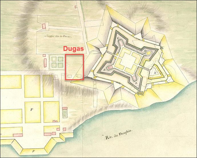
Abraham Dugas’s land, based on this map and a later reconstruction, was located in the red square and would wind up underneath one of the ramparts.

This sign explains the new fort design, which is the fort we visit today.
According to White, the 1705 expropriation list includes the following owners of the plots “adjoining the old fort.”
- François Gautrot
- Guillaume Trahan
- Jean Blanchard
- Simon Pelletret
- Michel Boudrot
Four of these five names are documented among the first settlers of Port-Royal. Trahan, for example, arrived aboard the Saint-Jehan in 1636, and Boudrot was a syndic in Port-Royal in 1639.
We don’t have early information about when Pelletret arrived, but based on the location of his lot, White reasonably assumed that he arrived about the same time as the others. Pelletret’s widow, Perrine Bourg, remarried about 1645, so he apparently died between 1642 and 1645.
These men received the first land grants in Port-Royal, very close to or adjacent to the fort, which makes perfect sense for the King’s armorer, trusted advisors, officials, and syndics.
By 1705, these men had long since passed away, and it’s logical to deduce that their heirs were the current owners of these plots at the time of the expropriations.
In her 1994 thesis, based on these descriptions and additional maps, Nicole Barrieau recreated the various forts, property, and the evolution of land grants in Port Royal.

On her reconstructed map, we can see the location of the Dugas land at the furthest left point of the rampart. Abraham Dugas apparently had two lots, side by side, which, according to the 1702 Labat map, had two structures, presumably homes, built on them. Together, they were valued at 47 livres.
The 1708 Map
In 1697, Port Royal was returned to the French under the Treaty of Ryswick, but that certainly didn’t last.
In June 1707, Port Royal was attacked by the British and burned yet again. The following year, another map was drawn for the purpose of reporting the conditions in Port Royal to the authorities in France. The bad news is that so many homes were burned. The good news is that it’s an extremely detailed map with a wonderful legend.

On this 1708 map, we can clearly see the locations of Abraham’s son, Claude Dugas, at far right, his neighbor Boudrot, and the fields between them. To the left of Boudrot, in the trees, we can barely make out a name something like “Venture,” a dit name short for Bonaventure Terriot (Thériot).
At left is Abraham (Dugas) dit Grivois, the son of Martin Dugas and grandson of Abraham, the armorer. The “dit Grivois” comes from Abraham’s stepfather, Claude Guedry dit Grivois.

Beneath that label are the marais, or marshes, of Grivois. This section is believed to be Abraham Dugas’s land after Port Royal burned at one time or another, and he was awarded land to the west of town. If not in 1654, then in 1690. Abraham was still living right across Allain Creek, so he had quick and easy access to the fort.
It makes sense that the armorer would live here. The battlement reinforcements were along the river.
Fortunately, the curves of Allain Creek are well documented as well, which makes this land relatively easy to identify today. The dykes are readily recognizable along Abraham’s land, between his fields and the river, and those same dykes still exist.
There’s one more piece of evidence that suggests Abraham was awarded land across the Creek from the fort fairly early, perhaps even at the same time he received his lots in town.
In 1705, Claude Dugas, Abraham’s son, signed a letter that said he had lived on his land for 60 years, which dates to 1645. This narrows the probable arrival date of his father to 1645 or earlier. Claude had to be referring to Abraham’s land, because Claude wasn’t born until 1649.
Let’s Visit Abraham!
I visited Port Royal, which is now Annapolis Royal, for three glorious weeks in the summer of 2024 with my two wonderful cousins, Mark and Manny.

Here, we’re doing what we did for the time we spent together – smile – a lot. What makes this photo extra-special is that we’re standing on Abraham Dugas’s dyke!
I did find Abraham’s land, but I surely wish that before I visited, I had found this tidbit written by a descendant of the New England family who was issued the land British authorities seized from the Dugas family when they forced the Acadians from their homes in 1755
The following extract is from the Nova Scotia Historical Review, Vol 2, Number 1, 1982, pg. 48, Story of Captain John Harris of Clements by Leone B. Cousins.
The Harris family lived on the Annapolis Basin on the property often referred to as the “Dugas meadow” since it had originally been “Lott 24” or the Dugas grant, the home of the Joseph Dugas family prior to the exile of the Acadians in 1755. A motel is located on the same site today.

The old Harris cemetery is immediately west. The family had settled on a tract of land near the fort prior to 1755 and witnessed the expulsion. On the Dugas property he grafted apple trees in the old French orchard on the property.
Clearly, Leone Cousins, the Harris article author, didn’t know the story behind Abraham Dugas and his descendants. Why would he? But he knew enough from after the Expulsion to provide useful information, context, and another tidbit.
The Joseph Dugas that Cousins references is the son of Abraham Dugas dit Grivois, the man shown on the 1708 map. In 1755, Joseph Dugas was 50 years old, and indeed, he had a perfect view of those horrible transport ships sailing up to the wharf in Annapolis Royal as the Acadians were rounded up and forced to board, leaving everything behind, and watching their farms burn.
But one thing survived. Cousins tells us there was an old French orchard with apple trees when John Harris obtained the Dugas property that apparently still survived in 1982.

I didn’t find the Dugas orchard. However, this ancient tree on the Girouard land from the same timeframe, probably springing from the same seeds brought with the settlers from France, gives us a sense of what it might have looked like.
I’m going to take you along with me in the exact order that I discovered the various pieces of Abraham’s land during my visit to Annapolis Royal.
I prepared for my visit by correlating the 1708 map with present-day Google maps. At that time, I hadn’t yet seen Nicole Barrieau’s thesis, so I didn’t know about the reconstructed map or Claude’s 1705 deposition.

This aerial map shows Fort Anne in the red box in the upper left.

The purple pin labeled “Scenic Acadian Family Historical Site” marks a short dirt road across from the fort. It crosses the old railroad, now a railtrail, and leads to a sign on the riverbank of the Annapolis River.
Directly across Allain Creek, at right, you can see the western ramparts of the Fort Anne site, including part of the white garrison visible behind the bridge.

The sign on the tip of Abraham’s land overlooks Granville Ferry across the Annapolis River, in front of the mountains, with the white church visible in the distance. Across the mouth of the Allain Creek or River, at right, we see the fort’s western ramparts and the roof of the garrison. The sign provides information and historic Acadian-era maps about this location, including that the Dugas village was called Sainte-Marie.

This location corresponds to Marais de Grivois on the 1708 map, so this is the waterfront edge of the land belonging to Abraham Dugas, looking north.
Farther southwest on the aerial map, the red rectangle marks the part of Abraham’s land we hiked and the Annapolis Royal Inn referenced by Leone Cousins in the Harris family document.
The red arrow at the top points to the Annapolis Royal Historic Gardens, which we’ll visit shortly.
Let’s start our visit with Abraham Dugas in the 1600s at the fort.
Fort Anne, Previously Known as the Fort at Port Royal

Not much remains from d’Aulnay’s original fort, but this cross, probably from a rosary, was excavated there.
Catholicism was the spiritual anchor for Acadian families, one they were willing to lay their lives on the line for. We already know how important the church was to Abraham. In 1673, as the trustee, he oversaw raising funds to rebuild the church and probably oversaw the reconstruction of the church as well.
He assuredly prayed many rosaries here.

Archaeologists found this 1651 stone tumbled over on its side near what appeared to be the entrance of the original fort, located near the southwest ravelin of the present-day fort. It is probably a foundation stone, cornerstone, lintel or a gatehouse marker of the original fort.
It looks like a gravestone for Joseph de Menou, the eldest son of Charles de Menou d’Aulnay, seigneur of Acadia, but it isn’t. Joseph lived well beyond 1651 and returned to France where he served in the military. Why an 11-year-old boy was memorialized in this way the year after his father died remains a mystery.
Abraham Dugas probably helped build d’Aulnay’s original fort and may have helped set this stone himself. He certainly would have known the answer to the question of why.
Oh, to hear the stories Abraham could tell us.
The fort Abraham knew looked different from today’s Fort Anne, but it stood on the same point where the Annapolis River meets Allain Creek

On this aerial, it’s easy to spot the shape of the fort depicted in the 1702 drawing, including the location of Abraham Dugas’s lots that were expropriated a few years after his death.
Abraham’s Town Lots

This footpath that exits the fort crosses the “edge of the ditch” that borders Abraham’s land as described in the 1705 expropriation document.
Abraham walked here.
The land across the street is Abraham’s original land.
Just to the left, along St. George Street, we find the Fort Anne Café which appears to stand on Abraham’s land too.

I sat here, in the Fort Anne Café, on land where Abraham stood, walked, and, depending on where his house stood, where he ate his meals too.

Here’s to you, Abraham. I was only about 375 years late for dinner.
Walking the Fort
After lunch, I walked with Abraham through the fort and along her ramparts.

From this perspective, we are looking southwest, down the Annapolis River toward the Annapolis Basin, which empties into the Bay of Fundy through Digby Gut.

Walking along the bastions and ramparts, we see the same view today. The tip of Abraham’s marsh is visible at left, across the Allain River.

Abraham stood here too, watching for the sails of English warships. He saw them arrive at least four times in his lifetime.

Much of the original point has eroded away, and the remainder is reinforced on both sides of the mouth of Allain River, which was called Allain Creek at the time and sometimes still is today.

Cannons stood on the top of the ramparts facing the Annapolis River, then known as the Rivière du Dauphin.

Cannons faced the river in the original fort built in the 1640s. However, the fort deteriorated to the point where it had to be rebuilt, and by 1690, there were no cannons mounted. Of course, that was when the English came calling in the worst of ways.

Mom travels with me on these adventures when I wear her ring, and Abraham Dugas was her 7th great-grandfather. Mom, we came home to meet Abraham.

As we follow the rampart southwest along Allain Creek, the rest of the Marais de Grivois comes into view. The marsh stretches from the river’s confluence to the red railroad bridge, barely visible at far left.

Proceeding further along the rampart, we see the marsh below the fort, then Abraham’s marsh across the river. Beyond the bridge, some of Abraham’s fields can be seen on the other side of the road.

A sign educates visitors about how the Acadians built dykes to keep seawater out and let fresh water drain away. It took about three years to turn salt marshes into productive farmland

The Allain River is tidal, which means that at low tide, the river’s mudflats are exposed. At high tide, brackish water would soak the fields and marshes without the dykes. The muddy banks of the river are visible in the distance, across the road.

Standing at the highest point in the fort, we can see Abraham’s land on the far side of the bridge. This marshland is dyked, and Abraham lived further west on higher land.

I wanted to capture the feel of the fort and ramparts across from Abraham’s land, so I took a panoramic photo which curved the landscape a bit. These ramparts did not exist at the time, but the original fort and the second fort both stood here. The garrison at left did not exist either, but some garrison did in this general area.
Abraham spent much of his life on this sacred ground. He depended on the fort and its French soldiers to protect his family.

Abraham’s original lots in the town touched the fort on the east side, and Abraham’s marshlands and his other pieces of land stood just opposite the fort across the river. Regardless of which land he was occupying or farming at the moment, Abraham was close by and available quickly at hand whenever he was needed.
As we continue walking along the top of the fort’s ramparts, we round the south side and approach the cemetery where the original Acadians were buried beside the Catholic church.

The church and adjacent cemetery stood behind the fort.

The cemetery remains, but the Acadian graves in the Saint-Jean-Baptiste cemetery are unmarked. The marked graves belong to the later British Garrison Graveyard, and all but three date to after the Expulsion in 1755.

The unmarked Acadian graves lie in this peaceful, grassy area beside this giant linden tree. Major Norman planted this tree and others in front of the garrison and the old Acadian portion of the graveyard in the early 1800s.

The church that Abraham helped build stood here, at this marker, across the path from the old cemetery. When the fort was rebuilt, the stones from the church that had lain in ruins since 1690 were used, which upset the priest.
We can see the confluence of the Annapolis River and Allain Creek in the distance, peeking out from between the ramparts.
D’Aulnay’s body was recovered after his May 1650 drowning death. He managed to hang on to his capsized canoe for 90 minutes before succumbing to hypothermia in the frigid waters of the river basin. According to Nicolas Denys’ journals, d’Aulnay was buried beneath the floor of the church, an honor reserved for governors, clergy, and high-ranking officials. During 1932 archaeological excavations, a burial was discovered beneath the sanctuary floor, here, exactly as described by Denys.
Abraham knew d’Aulnay well and would have been a first-hand witnessed to these events.

At left, you can see the church marker standing alone on the rampart. The Acadian graves lie in the grassy area, and the later British gravestones stand beyond
Abraham stood here for an untold number of funerals. He probably solumnly bowed his head here for the funerals of his own children. Conspicuous gaps between three babies born between 1648 and 1654 leave room for another baby, maybe two.
This cemetery was in use until 1654 when the English took Acadia and burned the church, then between about 1673 when the new church was built and 1690 when it was burned again, although it’s uncertain how much the Acadians utilized this cemetery in the 1670s and 1680s.
The Annapolis Royal Historic Gardens

My next stop was at the beautiful Annapolis Royal Historic Gardens. You might wonder why I’m here when I’m searching for Abraham’s land.

The answer is simple. You can see Abraham’s land from the Gardens, which sit directly across Allain Creek. Unfortunately, the dyke walk that would have let me stand directly across Allain Creek from Abraham’s dyke was closed that day, but there was still plenty to see.

This typical Acadian home in the gardens is probably much like the one Abraham Dugas built and his family lived in.

These homes weren’t large, and cooking was done in an outside oven.

Everyone, including all the children, lived in one room, with the exception of a small attic area.

Standing in the doorway on one side of the house, you can see Abraham Dugas’s land through the other door, across the river.

Walking through the gardens, peering over the eye-level marsh grasses, we can see the river and Abraham’s dykes on the other side in front of South Mountain.

This artist found Abraham’s land beautiful too.

I would have loved to purchase that painting.
Walking Abraham’s Land

Abraham’s land lies just outside of the town of Annapolis Royal, across the bridge.
Of course, today’s modern road divides Abraham’s land.

Crossing the bridge over Allain Creek, the first pull-off on the left-hand side leads to his dykes along the river.

We parked beside the road and began our journey back in time, walking along the top of Abraham’s dykes. I glanced back, uncertain if I should trust these centuries-old dykes that he spent his entire life building, then maintaining.

Photo courtesy of Cousin Manny.
Me and Cousin Mark beginning our walk. Days spent on the soil of the motherland are simply glorious.
We might have been cutting up a bit.
Which way?
That way!
No this way!

Photo courtesy of Cousin Manny.
Ok, we’ve composed ourselves now:)

Our walk clearly wasn’t at high tide. You can see the mud flats on the other side of the dyke, at left.

Photo courtesy of Cousin Mark.
These rivers, creeks, dykes, marshes, and mountains that line the river valley are indescribably beautiful.

We can see the wheat fields on the right side of the dyke.
Acadian neighbors worked together to build and maintain the dykes on one another’s land. No one could have done that work alone.
Survival required collaboration and cooperation.

These fields are not created by just one dyke. Several dykes work together to keep these fields dry.
In the distance, you can see this particular dyke curve to the right. Or maybe that’s actually two dykes that meet at right angles.
Regardless, they function as one, serving the same purpose.

Standing on the dyke, looking across the river at the rear of the gardens. If the Garden’s dyke walk had been open, we could have walked there.

Low tide. Don’t step down there.

Continuing deeper into the marshes.

Drainage channels carry fresh water through the aboiteaux. Their flaps let it flow out beneath the dykes and close against incoming salt water, which would contaminate the fields.

The dykes aren’t wide. You can see the mudflats at left, and the wheat fields at right.
This dyke curves to the right in the distance. That curve separates this field from Rice Brook.
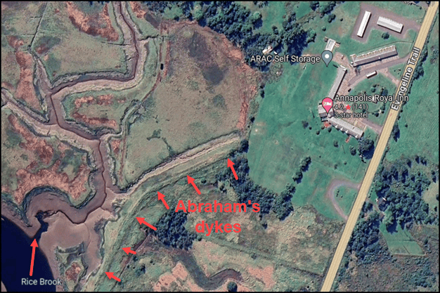
Complicating matters further, the land behind Abraham’s dykes is a patchwork of small streams and marsh. It was further divided by several arms of Rice Brook that drained fresh water from the hills into Allain Creek.

I didn’t want to venture too far into the marais, so I explained to Mom where we were, and that soon we would drive down the road and visit the other side of Abraham’s land where his house stood.

As we walked back toward the road, I looked back across Abraham’s field and noticed beehives along the tree line. There’s no evidence that Acadians kept bees.

Before leaving, I wanted to preserve the feeling of the entire landscape, so I took this panoramic photo that includes Allain Creek, Abraham’s dyke, his wheat field, and adjoining wooded land.
I hated to walk away. It’s so difficult to leave.
Crossing the road, I walked along the old railroad track bed, which is now a railtrail.

A small stream meandering through the marsh provides a beautiful view below the fort.

From the same spot, I turned toward Allain Creek, where the stream empties. The tip of Abraham’s land is on the far side.

That small stream actually isn’t very small. The fort’s ramparts rise in the distance. The fort is mostly obscured by the trees. Abraham probably saw something very much like this when he stood near here, except the fort and surrounding area were kept clear of trees and vegetation which provided cover for enemies.
We’ve been visiting the easternmost side of Abraham’s land that abutted Allain Creek, across from the fort. Let’s find his homesite.

Abraham’s actual homesite, as shown on the 1686 map, is about half a mile farther west along the same road, near the site of today’s Annapolis Royal Inn.
The stretch of Abraham’s dyke we can walk today extends more than 2,000 feet. The small red arrows to the right of Highway 1 trace it from behind the Annapolis Royal Inn.

I desperately wish I had known that the Annapolis Royal Inn was built on Abraham’s original land. I assuredly would have stayed there.

We parked in an abandoned horseshoe driveway about 300 feet east of the Inn and walked to the rear of the property where Abraham’s dykes began, or ended, depending on your perspective.

In the yard, someone had bulldozed a pile of stones into a fire circle. The end of the dyke is visible at left, in the small gap between the trees where it meets higher ground.

You find this exact type of rubble in locations where Acadian homes and barns originally stood.

Mark found a similar pile in a ditch on land that belonged to his ancestor Bonaventure Terriot. The stones had been cleared from the new greens across the road from the Fort View Golf Course clubhouse.

Further back on the Dugas property, behind the stones, the southwestern end of Abraham’s dykes transitions into the yard. That means this land is high enough that there were no swamps that needed to be drained, which, of course, is where Abraham built his home.
Let’s take a walk along the crest of the dyke, beginning in Abraham’s backyard.

This dyke opens through trees into a sunny area, with salt marsh fields on both sides.
Ahead, the dyke bends left along Rice Brook. From the other end of the dyke, we saw the bend curve to the right to join this section.
I suppose that means we met ourselves coming and going!

We walked further back into the marsh until we had a better view of his fields. Thankfully, someone has mowed the top of the dyke.

One of the tiny branches of Rice Brook flows in the tall grasses between the dyke and the field at the base of the dyke, at right. It’s very messy and swampy back here.

This dyke overlooks a marsh just beneath the hills of South Mountain.

We didn’t really want to venture any deeper. Uncertain about the condition of the dyke and the swampiness, we turned around and walked back towards the inn, which likely stands either near or where Abraham’s home once stood.
If you squint a little bit, you can see an Acadian home like the one in the gardens instead of the yellow Inn.

This 1710 map which was reproduced on the Allain Creek sign shows two homes very near the end of the dyke.
You may have grown tired of looking at Abraham’s land, but before saying goodbye to Abraham Dugas entirely, it’s important to fast-forward 400 years and address one final question about his heritage.
Was Abraham of Jewish Descent?
In a word, no, he was not. At least not on his patrilineal line.
However, I know why and how that rumor got started.
The rumor grew out of an early Y-DNA result. To see how, it helps to start with what Y-DNA can tell us about Abraham.”

Y-DNA is passed from father to son from generation to generation. No DNA from the mother is introduced, so the DNA remains unchanged except for occasional mutations that make Y-DNA extremely useful for genealogy. Those mutations also let us trace paternal lineages thousands of years into the past by following a line of mutations that act as breadcrumbs.
Years ago, DNA testing reported the Dugas haplogroup as “J2,” and J2 was known to be Jewish. That wasn’t wrong, because some men who fell into what was at that time called haplogroup J2 were Jewish, but not all, not by a long shot. J2 was renamed to its scientific SNP name, J-M172, years ago.

Haplogroup J-M172 was formed around 25,000 BCE, 27,000 years ago, someplace in the Middle East. That was long before the Jewish religion existed. Since then, several major branches and over 6,500 subgroups, or smaller branches, have formed. Some are found in the Jewish population, but most are not.
This is exactly why we strongly encourage men to take the Big Y-700 test. Nine Dugas descendants have joined the Acadian AmerIndian DNA project where results can be compared.

In the project table, the 37-marker tester is shown with the broad J-M172 haplogroup prediction.
Dugas men who have only taken the 12 to 111 marker STR Y-DNA tests receive a predicted haplogroup of J-M172 because that’s the best that can be done without a test that produces SNP (single nucleotide polymorphism) results.
Fortunately, three Dugas descendant men have taken the Big Y-700 test and received much more recent haplogroups. Those rows show a Big Y-700 test, and two show haplogroup J-FT168292.

The Big Y-700 test moved the Dugas men from a predicted haplogroup dating to 27,000 years ago to a confirmed haplogroup.
Haplogroup J-Z15977 for Abraham Dugas dates to about 1600 CE – just a little over 400 years ago, or about the time Abraham was born. Abraham’s son, Claude’s branch received an even more refined haplogroup, J-FT168292, dating to around 1750 CE. You can take a look for yourself using FamilyTreeDNA’s Discover reporting tool, here.
There is clearly a Middle Eastern influence prior to the Common Era, but there are no Jewish matches for Abraham’s descendants, and, in fact, there aren’t many matches at all. This could be because Abraham’s Y-DNA is rare, because France is significantly undertested, resulting from restrictive French laws prohibiting recreational DNA testing, or both.
Checking Discover’s Ancient Connections results for Abraham’s and Claude’s haplogroups provides a sanity check.

I reviewed each of the Ancient Connections that are obtained from DNA testing on archaeological remains from around the world and published in academic papers. The Dugas Ancient Connections are from Turkey, Iran, Turkmenistan, the Altai and other locations in Russia, Rome in Italy, Mongolia, Kazakhstan, and Kyrgyzstan. There’s no evidence of Jewish heritage.
The original J2 result was far too broad to tell us whether Abraham’s paternal line had Jewish ancestry. That assumption was based on a very early, very broad predicted haplogroup, and has been disproven today. Not enough data was available originally, but there is now.
The more refined Big Y results, the matches I reviewed, and the Ancient Connections provide absolutely no evidence for that claim.
Abraham would probably be quite amused to watch his descendants debate whether he was Jewish. He would probably also be fascinated to learn more about his own ancestors reaching back beyond the adoption of surnames.
Me, I’d be happy with connections in France.
Abraham, if you’re listening, we could surely use some help in identifying your parents, not to mention the original or correct spelling of your surname. If a descendant of a French cousin on your direct paternal line took a Big Y-700 test, it might give us a new lead – a literal message across the centuries.
Could you work on that, s’il vous plaît?

Share this:

Discover more from DNAeXplained - Genetic Genealogy
Subscribe to get the latest posts sent to your email.