
I’m struck by how much Michael McDowell’s life reads like a book with distinct chapters. One closes and as the wagon pulls away from the old homestead and another opens.
Michael did that at least twice in his adult life.
I first found Michael McDowell in present day Hancock County, Tennessee and worked my way backward in time, which was anything but easy.
For starters, Hancock County records burned, twice. At the time Michael lived, it was Claiborne County, whose records are incomplete. The place where he lived also bordered Lee County, Virginia and the border between Virginia and Tennessee was disputed for the entirety of Michael’s lifetime. And not to mention various census years that I need that are missing.
For decades, I’ve felt like the great genealogy gods have a perverse and somewhat perverted sense of humor. “Oh, you’ve overcome that road block, well, try this one! Hahahahah.”
In reassembling Michael’s life and that of his parents and children, I’ve had to connect many dots. Some snapped right in, like puzzle pieces nestling together like Russian tea dolls, but a few…not so much. The further back in time we go, the more scarce and difficult the pieces. It’s doesn’t help any that his father’s name was Michael McDowell too, as was his son.
Our Michael McDowell Jr. was born about 1747, possibly in Lunenburg or Albemarle County. His father’s trail goes cold in 1755 in Bedford County where Michael Jr. entered the Revolutionary War in 1777.
The name of Michael’s mother is unknown. She could have been from anyplace between Maryland and Lunenburg County, Virginia. If she was the same age as Michael’s father, she would have been born about 1720, or about 27 when MIchael Jr. was born. It’s likely that someplace, Michael Jr. has siblings.
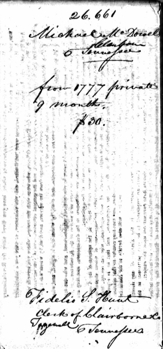
Revolutionary War Pension Application
One of our most valuable pieces of information about Michael McDowell is his application for a Revolutionary War pension found in Claiborne County, Tennessee. Two versions exist, one somewhat more detailed than the other.
Michael McDowell, Page 31 section 28, Michael McDowell S 1690 Virginia Service:
This day personally appeared before Samuel Powell, Judge of the Circuit Court of Law and this equity in Claiborne Co., TN. Michael McDowell, age 85, in order to obtain benefit of an act of Congress, passed June 7, 1832. He made this application 1832. States he entered the service in Bedford Co., VA 1777 or 1778. He was drafted to perform 3 months tour of duty and he belonged to Company of Capt. Arthur which was attached to the regiment of Col. James Calloway. He then marched to the lead mines in the western part of Virginia and built a fort, and also under Capt. Wm. Leftridge at the same Fort. And after his term expired, returned home to his residence in Bedford Co., VA, and again volunteered under Capt. Arther, and marched against the Indians, and again after returning home joined with some neighbors and friends with the citizens of the country calling themselves spies, to protect women and children from the skelping knife of the savage. He went to see his Capt. Arther who now lives in Kentucky and he is so parallized and so polsed? so that he can not speak, so as to be understood.
John Hunt a citizen of Claiborne County, Tennessee, certify that I am well acquainted with Michael McDowell, and it is reputed and believed in the neighbourhood where he lives that he was a Revolutionary War Soldier.
Affidavit of James Gilbert, one of the clergyman of the Baptist Church, state I am well acquainted with Michael McDowell.
John Hunt, High Sheriff of said county, makes the same statement.
This affidavit gives us a lot of information about Michael, including that he and his friends called themselves spies.
His age is given, which puts his birth about 1747.
We know that in 1777, Michael was 30 years old and living in Bedford County, Virginia. He was married by that time, with his son Edward born in 1773 and his son Michael (the third) being born before 1774.
Information from “TN Pension Roll of 1835” copied by William Navey:
Michael McDowell – Claiborne Co., TN – Private VA Line, $30 annual allowance – $90 amount received, Sept. 20, 1833 pension started – age 87 in 1835
State of Tennessee, Claiborne County This day personally appeared before Samuel Powell, Judge of the Circuit Court of law and equity in the state of Tennessee the same being a Court of Record, Michael McDowell age 85 years who being first duly sworn according to law doth on his oath make the following declaration in order to obtain the benefit of an Act of Congress passed June 7, 1832. States that he entered the services of the United States under the following named officers and served as herein states that he resided in the County of Bedford in the State of Virginia and some time in the year of 1777 or in the year of 1778 he was drafted to perform a three month tour of duty in the services his county and that he belonged to company commanded by Capt. Arthur which said company was attached to the regiment commanded by Col. James Calaway then marched to the lead mines in the western part of Virginia and we then built a fort and we were there stationed until my time of service has expired and then it was that Col. Calaway called upon us to volunteer our services in the cause of our country for the time of three months which this applicant did do in good faith and he states most positively that he did serve his country under the command of Capt. William Selfridge at the same fort and after his time of service had again expired this applicant returned home to his residence in the State of Virginia in Bedford County and some time after this applicant returned home he again volunteered himself under Capt. Arthur and he then marched against the Indians who were committing many defamations on the inhabitants of Virginia and the applicant states that he served in the campaign as long as his services was required by the commanding officer, but the precise time he does not recollect and then being discharged from service he returned to his residence in the County of Bedford. And this applicant begs leave further to represent to the department that some time after he had returned home from the last above mentioned campaign that he united himself with some of his neighbors and friends together with a vow to protect the women and children from the scalping knife of the savage and often performing a great deal of hard labour in the service of our country and after the spring of the year had set in and the savages had left the frontier we again returned home the applicant states that he believes taking the whole of his service together that he served in the cause of his country for the term of nine months although it may be more or it may be less. Said applicant also states that he has no documentary evidence of his services nor does he know of any living testimony by whom he can prove his services. He a few days ago went to see his Capt. (to wit) Capt. Arthur who now lives in the State of Kentucky and that he found that the said Arthur is paralyzed and so palsied that he cannot speak so as to be understood which now fully appears no reference to a document, herewith presented and signed by one of the Justices of the Peace in said state. Hereby relinquish his every claim to a pension or annuity except the present and declares that his name is not on the pensions roll of any agency of any state whatsoever. Sworn to in open court Dec. 1832
If this was sworn in December 1832, chances are very likely that Michael had already had his birthday for the year. His year of birth subtracts to 1748 in this document.
In a publication listing Tennessee veterans of the Revolutionary War, Michael is listed as having been born in 1745. The source of this information is not given.
I obtained Michael McDowell’s Revolutionary War Pension file from the National Archives.

The actual pension act was found in Michael’s pension papework.


I originally though that Michael signed this document himself, but after looking more closely, he didn’t.

The “X, his mark” is present. Of course, we don’t know from this document alone whether Michael was simply too elderly and too feeble to write, or if he never could. Other documents will tell that story.


$90 was a lot of money in 1832 – enough to purchase a farm or at least land to clear for a farm.

From these documents, we can put together roughly the following timeline:
| When | What | Where |
| 1777 or 1778 | 3 month tour | Lead mines with Arthur and Callaway |
| Additional 3 months at lead mines | Callaway requested, served under Leftridge | |
| Home after the second three month tour | Bedford County | |
| Some time later | Volunteered again to march against Indians | With Arthur |
| Returned home | Bedford County | |
| Some time later | Spied on Indians – returned home after spring when Indians departed |
Michael states that he served 90 days in total, more or less. Given the dates above, his time spying on the Indians would have had to have been in either late 1777 or late 1778. If he was drafted in 1777, most of that year would have been consumed with the 6 months contiguous duty at the lead mines.

This final document is interesting in that it lists Michael as an invalid. It’s possible, at 85 years of age, that his invalid status is simply a result of his age, meaning he can no longer farm, and had nothing to do with his service or an injury. He did not apply in 1818 at which time destitute soldiers could apply.
These documents reveal more too. Michael left Bedford County and marched to the western part of Virginia. At this time, Tennessee and Kentucky didn’t exist, so Virginia just trailed off into nothing – with no western border as shown in the Fry and Jefferson map from 1775, below.

Revolutionary War Service
In the book, Virginia militia in the Revolutionary War: McAllister’s data we find several references to lead mines as well as the officer’s surnames noted in Michael McDowell’s pension application.
This book reveals: Capt. Benjamin Arthur R. Sept. 29, 1781 from Bedford County. James Callaway Co. Lt, S, Dec. 8, 1778. We then find Lt. Col. William Leftwich, S. Feb. 28, 1780. I’m not quite sure what that means, but it does confirm that they served.
Bedford County: 1776. Capt. Wm. Leftridge against Tories and Indians at Lead Mines, 47, 157.
This suggests that there might have been an encounter.
1780 – Capt. Robt. Adams’ Company guarding Lead Mines, 153.
Greenbrier County 1780: Capt. Thomas Wright raises a Company to go against the Indians at Detroit. But it was marched to Lead Mines on Holston, and then to Logan’s Station in Kentucky.
Jarvis Fields, in his pension application tells us that he served from Bedford County as well and he was called to duty in 1779 by Col. Calloway for guard duty at New London, in Bedford County, “the British prisoners taken at the Cowpens being confined there and at Lynchburg.”
Henry Cartmill who served from Botetourt tells us this about the possible location of the lead mines:
At another time he ranged the mountains between Fincastle and Sweet Springs in search of Indians. Himself and many others assembled at the lead mines in Wythe to meet Col. Fergerson who was said to be advancing from the Carolinas with a large force of Tories. After going as far as Stone House in Botetourt, they were stopped by Col. Skillern, commanding the Botetourt militia, until more men could be collected. News reaching them that the Tories were dispersed, they returned home.
Colonel Ferguson was killed at the Battle of King’s Mountain in October 1780.
William King states that he was enlisted in Bedford County in 1778 and for two months, he guarded the lead mines in Wythe County. Other men refer to the lead mines in Wythe County, as well.
William Murphy is very detailed in his pension application:
About Aug. 1, 1776, from Bedford under Capt. William Leftridge, Lt. Calloway, Ensign Joseph Bond. Guarded Chiswold lead mines till relieved by other troops. In April, 1777, was substitute three months for Lewis Dusee (?), who was drafted from Thomas Jones’ Company in Henry. Served under Capt. Peter Herston, Lt. William Ferguson, Ensign Edward Tatum in Col. Christie’s regiment. Marched 200 miles to Long Island in the Holston to stand guard during a treaty with the Cherokees.
Volunteered in April 1780, to serve three months against the Cherokees. Went as sergeant under Capt. Jno. Clark and Lt. John Bond, Gen. John Sevier being in general command. Marched to the headwaters of the Tennessee and killed a number of Indians, with the loss of Capt. Davis and Lt. Bond killed, and Jasper Terry wounded.
In February 1782, volunteered three months under Capt. John Clark, and Lt. John Murphy, of Washington County, N. C. (now Tenn.), Col. J. Brown commanding the regiment, and marched across Nolachucky and French Broad in pursuit of the Indians who had attacked Sherrill’s Station on the frontier, losing one of their number in the attack. We overtook a band, supposed to number 60 to 100, and killed, as was said, thirteen of them. In August 1782, drafted against the Indians again and hired George Doggett as substitute, but Gen. Sevier insisted that I go. Served under him in company of Capt. Thomas Wood and Lt. Vathan Breed, all the officers being of Greene Co. (Tenn.) We destroyed several Cherokee towns, killed a number of Indians, and took some prisoners. John Watts, a half-breed gave up a white woman named Jennie Ivey, who was taken from Roane’s Creek a year before.
The reference to Chiswold’s lead mines gives is a critical clue.

This waymark exists today at the intersection of interstate 77 and Route 52, but the actual mines were about 10 miles further south in the Austinville Community on a bluff on the south bank of New River. Known variously as the mines on Cripple Creek, the Austinville mines, or the Wytheville mines, they were discovered in 1756 by Colonel John Chiswell.
The original Fort Chiswell was built during the French and Indian War where the current village of Fort Chiswell stands, but was paved over when the intersection of I77 and I81 was constructed in the 1970s.
Given that Michael McDowell said that they built a fort, it’s probable that they built a fort at the actual mines to protect the lead, an extremely valuable commodity to both the militiamen and the Tories who were attempting to capture the mines.
The website, Diggings, below, shows the mine with the green balloon and the deposits in red. The information on the site states that production at the Austinville East Lead Zinc Mines began in 1753 and concluded in 1981.

This would be where Michael McDowell camped and built the fort.

Today, the two routes from Bedford County to the lead mines, both through gaps in the mountains, would be either 110 miles or 125 miles.

A Google satellite view of the vicinity shows extensive mining efforts at Chiswell Hole.

If the location of the original lead mines is accurately positioned by the green locator of the Diggings map, the original mine location would be where the white roofed building, below, is located today.

Unfortunately, none of these roads are “drivable” today utilizing Google street view. Maybe in a few years.
Indians, Spies and Scalpings
In both application versions, Michael mentions being an Indian spy, banding together to protect people and that the Indians subsequently left the frontier. What can we discover about when and where this might have occurred?
Michael says he “marched against the Indians, and again after returning home joined with some neighbors and friends with the citizens of the country calling themselves spies, to protect women and children from the skelping knife of the savage.” He also mentions that he and his fellow spy citizens returned home in the spring, meaning they tracked Indians in the cold of winter.
We know that this was after Michael marched to the lead mines, which was probably about April 1777, based on the information unearthed about the mines and other men who served there, and after Michael served with Col. Leftridge and then marched with Captain Arthur against the Indians. After all that is when he “joined with some neighbors and friends.”
In Michael was at the lead mines in April of 1777, then he went home in about October of 1777.
We know that this was probably related to the peace treaty signed with the Cherokee Indians in July 1777 ceding the Watauga lands or in July of 1781 when they ceded more land, both events taking place at the Long Island of the Holston. Another treaty during this time was the Treaty of Fort Pitt signed in November of 1778 with the Delaware. It’s difficult to know which event might have resulted in the Indians leaving the frontier as he mentioned, an event that allowed him to finally return home for the last time – although it’s most likely prior to 1781.
Two articles shed light on this time period and events that clearly impacted Michael McDowell.
The first is found in The Virginia Magazine of History and Biography, Vol. 23, No. 2 (Apr., 1915), pp. 113-123, article by David I. Bushnell, Jr.
In the first of a series of articles titled, “The Virginia Frontier in History – 1778”, David Bushnell tells us that in 1774, Cornstalk, Chief of the Shawnee entered into a peaceful agreement with Lord Dunmore and subsequently became friendly with the English.
However, in November 1777, at Fort Randolph which was located at Point Pleasant (now West Virginia,) Cornstalk along with his son were brutally murdered. Ironically, Cornstalk had come to warn the settlers and his killing was in revenge for the murder of a settler by an Indian.
During the winter months that followed, the settlers realized what grave danger they had brought upon themselves by killing Chief Cornstalk and prepared for the now-expected attack by the Indians. In January 1778, Col. William Preston sent a letter from Montgomery County, Virginia, begging then-governor Patrick Henry of Virginia for assistance, expecting the Shawnee to descend upon the settlers at any time.
A widespread attack was expected, “upon all Frontier Inhabitants from Pittsburg to the lower Settlements of Clinch and the Kentucky.”
Col. Preston writes:
“I acknowledge, Sir, that this detestable murder was committed by backwoods men who ought to have behaved in a manner very different; and I am sorry to inform your Excellency that upwards of 100 persons in the County alone have yet refused to take the Oath of Allegiance to the State, many of whom are disarmed and the remainder soon will, who cannot claim, nor are they entitled to Protection while they continue Obstinate.”
“The inhabitants in this and the neighboring counties, especially those most exposed to danger are in the greatest consternation. Several thousand good subjects ought not to suffer for the indiscretion and obstinacy of a few. Being generally in low circumstances, they are not able to remove and support their families in the interior parts of the state, and by continuing at their homes, without the assistance of government, or the immediate interposition of Providence, they and their helpless families must fall a sacrifice to savage fury and revenge.”
“Should this (assistance) be omitted or delayed, I am fully convinced from long experience that this county or a great part of it will be depopulated before May next and the enemy, like blood-hounds, will pursue until they overtake their prey, even to the south side of the Blue Ridge, as they did not many years ago.”
Preston goes on to ask for provisions, stating that the lack of salt prevented people from laying up the quantity of pork that they would have otherwise done. He says they will be out of provisions in two months. Normally pigs butchered in the fall would last until at least the following summer when crops could be harvested.
Preston also asks for Indian corn to be purchased and says there is none in his or neighboring counties. Furthermore, “the want of lead is a most discouraging circumstance. They offer any price but they cannot purchase it.”
Guns don’t work without bullets and lack of lead for their muskets made the settlers little more than sitting ducks.
According to the response recorded in the “Journal for Council for 1778” in the Virginia State Archives, Greenbrier County also submitted a request and on February 19th, the Council agreed to the following:
- One pound of lead for each militia man
- To direct trusty scouts to range towards the enemy’s country
- To advise proper stockades for receiving the helpless inhabitants, wherever the savages have in in their power to penetrate
- To direct the County Lieutenants of Botetourt and Montgomery to consult together on the expediency of establishing a post near the mouth of Elk River for keeping up the correspondence between GreenBrier and Fort Randolph
- To do so in the matter they judge best to reinforce the garrison at Fort Randolph with 50 men from the militia of Botetourt
- That earnest and close pursuit of the foremost scalping parties be made in order to discourage others
- To apprehend and deliver up the people concerned in that murder
On March 27, 1778 they recommended ordering 50 men from Rockbridge County, Virginia to Fort Randolph and 50 men each from Botetourt and Greenbrier County to “post at” Kelley and authorized 1000 pounds for “commissary.”
The order to “direct trusty scouts to range towards the enemy” stems from the following document passed by the General Assembly on May 5, 1777 as found in Henning (Vol IX, p294-295):
“The lieutenant or next commanding officer of the several counties on the western frontier, with the like permission, shall appoint any number of proper persons, not exceeding 10, in any one county to act as scouts for discovering the approach of the Indians…who on such discovery shall immediately give notice thereof to such militia officer.”
The scouts were instructed not to fire on the Indians, except in self-defense, but only to report locations to the militia officers. Their job was to find the Indians and spy upon them. Their instructions were to not lose time, to stay constantly “on foot” and after they “have fully ranged the part of the country which it was supposed would take 2 or 3 weeks,” they should report back. They were to take their own provisions, but they would be paid for them. I wonder if that ever happened.
However, now we know where the term that Michael used, “spies,” originated in this context.
Interestingly enough, on the back of a paper were listed locations, probably made by a scout, showing the locations visited. The author believes the numbers represent the number of miles:
- From Culbersons bottom to the big Crab Orchard – 60 (Crab Orchard is in Kentucky)
- From there to Maiden Spring – 15
- From thence to Elk Garden – 17
- To the Glade Hollow – 13
Underneath that is a total line and then 105.
- To Cowins fort – 10
- Moores fort – 5
- BlackMores – 2
- To Mockinson Gap – 18
- To ye Great Eatons (?) – 8
- To Capt Donelsons line – 8
Another total line and 174.
Fort Blackmore was located in what is now Scott County, VA, as is Moccasin Gap.
According to Familypedia.wikia, this 1774 copy of the Smith map with red circles indicates the locations of forts as shown on Daniel Smith’s original map, now in the Draper collection, item 4NN62. The red line became the Kentucky Trace.

This area includes part of the present Virginia counties of Tazewell, Russell and Scott from the Clinch River to the Holston.
Col. Preston apparently became more fearful and requested additional protection in May of 1778, the following being noted:
“The Board being informed of Col. Preston’s expored situation on the frontier and that is was apprehended (should be obliged to remove) most of the back inhabitants would quit their settlements, they do advise the governor to empower Col. Preston to keep a sergeant and 12 men stationed at his house as Draper’s Meadow to enable him to continue at his habitation and to encourage others to do so.”
In a second article in The Virginia Magazine of History and Biography Vol. 23, No. 4 (Oct., 1915), pp. 337-351 by David I. Bushnell, Jr. we find additional information.
A report detailed the importance of maintaining 4 forts, one of which is Fort Henry in Ohio County and one at Fort Randolph, which is on the Ohio at the mouth of the Kanawha river, the scene of the treacherous murder of Chief Cornstalk in November 1777. That act was the touchstone of the rebellion that caused the Indians to attack the settlers on the frontier. Fort Randolph was stated to be “200 miles distant from the settlements” and 150 men were requested for that location.

Indeed, Fort Randolph is about 266 miles from Bedford County, VA.

Also requested for the various forts was 1500 gallons of whiskey. That’s a LOT of whiskey!
The two documents presented…enable us to picture the frontier posts as they were during the summer of 1778. Small groups of militia, at widely separated spots in the vast primeval forests. Nearby were the clearings and log cabins of the settlers. Supplies were scarce and consequently difficult to obtain and of a high price: a condition which resulted in more than one expedition being either postponed or abandoned. Scouts were ever on the alert for the approach of the warriors from beyond the Ohio; the accepted boundary between the white settlements and the Indian Country later to become the Territory Northwest of the Ohio.
That same year a census of the tribes was prepared by William Wilson at the request of the War Office as reported in the Virginia Historical Magazine:


The tribes were widely separated and the number of hostile warriors was given as 330, certainly a very conservative figure; but nevertheless, they were sufficiently numerous to spread terror over many hundreds of miles of the frontier.
In the endeavor to gain peace for the Virginia frontier, and the friendship of the Indians beyond the Ohio, Congress planned a treaty to be held at Fort Pitt, July 23, 1778, to be attended by commissioners of the government and representative of the different tribes. This was destined to be the first treaty between the United States and an Indian Nation, and was signed September 17th.
Michael’s Revolutionary War papers take us back to Bedford County, Virginia where he lived after being dismissed the final time from his Revolutionary War service – and presumably once the region became relatively safe again after November of 1778.
What we don’t know is which spring Michael was referring to, 1778, which is unlikely, given the above information, or perhaps the spring of 1779.
Bedford County, Virginia
Michael McDowell Bedford County
Bedford County is mountainous and rough. I visited Bedford County, years ago, and Bedford isn’t much different from surrounding counties. In essence, Bedford is part of the Appalachian range which extends for thousands of miles as an expansive sea of craggy rocks interspersed with tiny patches of green that farmers have been trying to cultivate since before the Revolutionary War. It’s also breathtakingly beautiful with incredible vistas.
Bedford County hosts a section of the Blue Ridge Parkway, a beautiful WWII era road that runs along the summits of the mountains offering stunning vistas, in particular the Peaks of Otter in Bedford County, shown below – visible for a hundred miles in any direction on a good day.

This might have been particularly relevant for Michael McDowell’s father, Michael Sr., who we know lived in Halifax County, Virginia in 1752. This means that if Michael Jr. was born in 1747, he might have been born in present day Halifax County which was Lunenburg County at that time. Interestingly, you can see the Peaks of Otter from Halifax County, below, at a location called “Top of the World.”
Perhaps Michael saw these mountains and felt irresistibly drawn towards them – an area that was then the risky, unsettled frontier.

The photo above was taken from Halifax County, looking 50 miles distant to the Peaks. Did Michael live here, or see this on his way back and forth to the tobacco warehouses in Danville, in Pittsylvania County? As a young boy, did he dream of adventure there? One day that dream would come true.

Looking across the roof of the Peaks of Otter Lodge today, from the Blue Ridge Parkway.
Many of the men who settled in Bedford County were Scots-Irish, and before that, they were Scottish families, so trying to farm fields filled with rocks was nothing new to them. Perhaps it even reminded them somewhat of home, or the homeland of their fathers and grandfathers anyway.
After finding Michael McDowell’s Revolutionary War record, of course I began digging in Bedford County for more information.
Ironically, some of the information I found in Bedford County in June of 2005 referred me back to Claiborne County, Tennessee.
At the Bedford Co. Historical Society, I found a McDowell family file and it held a contact from California from 1989 and 1990 who descends from our Michael McDowell
The researcher mentioned that in Mary Hansard’s book, Old Time Tazewell, Michael’s son Nathan S. McDowell is mentioned as being of Irish descent, which the researcher interpreted to mean that Michael was born in Ireland. As it turns out, Michael Jr. wasn’t, but his grandfather, Murtough McDowell, was.
Blackwater River
On September 24, 1783, Michael purchased 75 acres on the North side of Blackwater River in Bedford County from James Stevens. and on March 22, 1784 the purchase was confirmed in court. Witnesses to the sale were Richard Richards, Skinner Devaul(?) and Ambrose Rains.

It’s important to note that this does not say Michael McDowell Sr. or Jr., which it surely would have stated if there were two Michael McDowell’s living in the same county at the same time.
On the 1782 Bedford County tax list, we find only one Michael McDowell, listed with 1 free male above 21 years, no slaves, 4 horses, 11 cattle with 1 white tithable, himself.
Unfortunately, the tax list is semi-alpha, which means it’s not in household order, so we can’t look at the list to identify his neighbors. There are no other McDowell residents listed.
In 1783, we find Michael with 1 poll tax, 1 male over 21, 2 horses and 4 cows. Most people had both more horses and more cows that Michael.
By 1784, Michael is gone from the tax list but he doesn’t sell that land until 1793 as a resident of Wilkes County, NC.
It appears that the area of Bedford County where Blackwater River was located became Franklin County.
The Blackwater River runs for about 20 miles as the crow flies, west of the area called Callaway, to the left of the pin below, and the county line at far right where it opens into what is now Smith Mountain Lake, formed by the Roanoke River.

Given that Michael served under Colonel James Calloway, which means that Michael probably served with his local muster group, my strong suspicion is that Michael lived near James Calloway. Given that Callaway is located on Blackwater River, Michael probably lived in this region too.
Indeed, this is probably where he grew up because his father apparently applied for a land grant in 1754 on the Black Water River – although beyond the initial application we never find any additional informatoin about Michael Sr.’s 400 acres. He could well have forfeited the grant for any number of reasons.
The north and south branches of Blackwater are born near Calloway and flow eastward to the Roanoke.

Today, this area is a mosaic of farmland, but at that time, it was probably still forested, and men like Michael would fell trees to make room for fields.
Someplace, Michael’s land was probably here in this crazy-quilt mosaic of farmland and forest.

Today, Callaway Road where it crosses the Blackwater River. This would have been a ford when Michael lived here.
The Arthur family lived nearby too, with several deeds showing land near Goose Creek, in Bedford County, 4 or 5 miles east of the Roanoke River where Blackwater River empties.
This was Michael’s stomping ground growing up. It’s probably where he married his wife.
We know that Michael McDowell Sr. was on the Bedford County tax list in 1755, and given that our Michael was born in 1747 or 1748, the 1755 Michael had to have been Michael Sr., not Junior.
Or stated another way, it couldn’t have been Michael Jr. and there is a small possibility that the 1755 Michael was not Michael Jr’s father. Given that he was the only McDowell living in Bedford County by the same name, there’s a good chance that the 1755 Michael is indeed Michael Sr., the father of Michael Jr.
I checked all Bedford County deeds 1761-1771, wills 1759-1810 and court orders 1754-1761 – no Michael McDowells. He certainly kept a low profile.
There are also records in Bedford County for one Ephriam McDowell, no known relationship and these two male lines carry completely different Y DNA.
Michael McDowell bought land in Bedford County in 1783, but in 1784 he is not listed on the Bedford County tax list and a Michael McDowell is listed with 1 white poll in adjacent Botetourt County. Is this the same man? If so, was he trying out different locations? Why did he leave just after purchasing land?
If this isn’t the same Michael McDowell, what happened to that second Michael McDowell in Botetourt County? Where did he come from and where did he go? The only other McDowell in Botetourt in 1784 was George. However, there was a Michael in Botetourt, earlier, in 1774 who was found to be delinquent on his taxes.
If this was our Michael in Botetourt, he clearly didn’t stay and it was a very short chapter in a very long book. Our Michael is also not the Michael McDowell who served out of Pennsylvania in 1776-1777 in the Revolutionary War.
Where is our Michael?
Pat Bezet and Mary Kay McDowell
A few years after visiting Bedford County, I found Pat Bezet on an old Rootsweb board along with Mary Kay McDowell, the wife of Les who Kay believed to be a Michael McDowell Jr. descendant through Michael’s son, Luke. These women had done a massive amount of research on Michael and family, and I would spend the next several years following in their footsteps, trying to add additional tidbits. They were both very generous about sharing their work. However, it was interesting that even though we were all plowing the same fields, so to speak, that we all found things that had either been overlooked by the other parties or found different records altogether. Six eyes are obviously better than any two. By reviewing available records again, I’ve recently found things that all three of us missed previously.
Mary Kay McDowell systematically sifted through nearly all of the published Virginia sources available in the 1970s, 80s and 90s.
The results of our research and trips are intermingled in this article, with many thanks to both ladies.
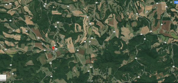
Albemarle County, Virginia
It’s likely that Michael McDowell Jr. was born in 1747 or 1748 in Lunenburg County, Virginia or possibly in Albemarle County. Michael’s father, Michael Sr. was found in both locations.
Keep in mind that Halifax County where we positively identify Michael McDowell Sr. in 1752 was Lunenburg before that.
We find a similar name in Albemarle County, VA in the 1745 road records, dated June 27th in which Andrew Wallace was appointed surveyor of the highway from D.S. to Mitchams River and both Merlock (also transcribed as Mirlock) McDowell and Micha McDowell were ordered, along with other men to clear the road. Albemarle county as was formed from Goochland in 1744, although deed, court and will records did not begin in Albemarle until 1748. Albemarle road records are lost beginning in 1748. Research into Albemarle records from 1748-1753 produced nothing, nor did research into Goochland deed and will records from 1731-1749.
The name Merlock sounds very close to Murtough, Michael’s father’s name, raising the question of whether Michael was Merlock’s brother. It’s also worth noting that in Maryland, Murtough’s name was also spelled Murto, with the surname as Mackdowell and Mackdaniel. Names were spelled as the person hearing them understood them and spelling wasn’t standardized at the time.
If Michael was in Albemarle County, he was familiar with the Three Notch’d Road which is the road the crew where he was assigned was instructed to clear and open in 1745. Men were assigned to crews along the road where they lived.
The Virginia Department of Transportation document titled, “The Route of the Three Notch’d Road: A Preliminary Report” written in 1976 shows the “1740 House,” an old tavern near the site of the D.S. Tree, near present day Ivy Virginia. Today the building, also known as the “D. S. Tavern” is on the National Register of Historic Places.
The original 3 Notched Road was begun about 1742 and the route was marked the entire length between Richmond, VA and the Appalachian Mountains in Augusta County, VA – including running directly through Albemarle County and is currrently US 250. US 250 was rerouted in some places, but is basicaly the same road in Albemarle County.
If indeed this is our Michael’s father in the 1745 road record, this 1740 House which stood and functioned as an ordinary at the time was probably intimately familiar to him, both inside and out.

The D. S. Tree is reported to be in the final segment of a the “Three Notched Road” between Secretary’s Ford on the Rivanna River, (near the old woolen mill adjacent to I-64 on the east side of Charlottesville) to the D. S. Tree in Michael Wood’s road, the road east from Wood’s Gap to Ivy.

Today, this private home is at the intersection of Dick Woods Road and 250.
Early deeds refer to Stockton’s branch of Mitchum River, and also Stockton’s ford.
An aerial view shows the mountainous area between Ivy and the top of the mountain range.

According to Edgar Wood’s History of Albemarle county, Virginia, the D. S. Tree had the initials of David Stockdon, an early patentee of land nearby, carved into it. That tree no longer exists.
Here’s a section of what was called the “Three Notch’d Road” also known as the Mountain or Mountain Ridge Road, now US 250, which today intersects with the Ridge Parkway.
Below, Mountain Ridge Road, another name for the Three Notch’d Road.

Today, on the Blue Ridge Parkway at Jarman Gap.
The Appalachian Trail runs alongside Skyline Drive, which is the Blue Ridge Parkway. I’ve hiked much of this area. You can see Wood’s Gap Road in this aerial.

Below, the road descending to Lickinghole Creek.

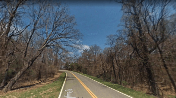
Here’s the view on Three Notched Road crossing Lickinghole Creek today.

Three notched road ascending the Blue Ridge below.

Jarman(s) Gap Road today just before it begins ascending the mountains. Wood’s Gap is now Jarman or Jarmans Gap.

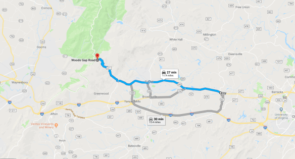
Google Street View does not drive on roads with no center line. The trip from Jarman’s Gap Road alongside Lickinghole Creek, above, to Jarman Gap which is one of two gaps crossing the mountain range is maybe 5 twisty-turny miles on road 611 – complete with switchbacks.

And of course, a 3 notched tree. The original D.S. tree stood east from Wood’s (now Jarman’s) Gap to Ivy, probably on the same property where the 1740 D.S. Tavern stood.

Ivy to Jarman Gap. Today you must use the Park Entrance, but not so then when they took the more direct route up the side of the mountain, marked with red arrows.

Michael Sr. worked here, opening the roads still in use today, but looking very different. The area where he was assigned was from the D.S. Tree to Mitchums River, which is Mechums River today – a distance of about 3 miles.

That means he would have lived someplace along this route probably on a spring branch of a creek where fresh water was available. This is likely where Michael McDowell Jr. was born.
I’m not convinced that the blue 250 portion is the original road, but Google didn’t drive down 738 which looks like it might have been the original road.
However, there is a portion where 738 and 250 join, and that was likely the original portion, as is the portion where Dick Wood’s Road and 250 intersect.

In fact, when I enlarged the photo, I could clearly see 3 Notch’d Trace, the portion that exists today, and the portion which no longer exists. You can see Mechums River at left and where it is crossed by 250. At right, with the arrows is the old section of 3 Notch’d Road.

Michael McDowell Sr. labored to maintain the road so that horses and wagons could ford Mechums River, below, today where 250 crosses. This could have been Stockton’s ford referenced in the various early Albemarle deeds.

At the intersection of Ivy Road and 3 Notch’d Trace, a remaining segment of the original road, we can see the Appalachian Mountains in the distance.

Those mountains would beckon to Michael Sr., whispering, “Come,” and he did, but first he took a detour.
Lunenburg County, Virginia
Lunenburg County, where we find Michael next, was formed in 1745 from Brunswick County. The 1748 tax map for Lunenburg is the first tax list available, so we don’t have any way of knowing whether or not Michael Jr., born about 1747 was born in Lunenburg or perhaps Albemarle. It’s also possible, although unlikely that the Michael in Albemarle wasn’t Michael Jr.’s father, and that he was still in Maryland before arriving in Halifax County.
Pat included the Lunenburg County 1748 tax list where Michal McDanel was shown with 1 tithe in the district taken in June by Mathew Talbot from Bleu Store to Little Roanoke. The Roanoke is now called the Staunton which forms the northern and much of the eastern border of Halifax County.

Sunlight on the Southside by Landon Bell provides the Lunenburg tax lists, where extant. We find the McDowell family mentioned in the intro portion as being from Lunenburg Co., VA before they went to NC.
In 1749, we find Michael McDowell in William Caldwell’s district, which bordered Halifax on the north on the Staunton River. In 1752 Halifax was formed from Lunenburg, where Michael McDowell. had 1 white tithe, meaning white male over 16, and no negroes.
In 1749, the Lunenburg road orders included a Michael McDaniel, who may have actually been Michael McDowell.
In 1750 we find Michael McDowell in Nicholas Hale’s district with one tithe and neighbors that included Jacob and John Pybon.
In 1751, Michael is missing from the list and in 1752, Halifax County was formed from Lunenburg. We already know that Michael McDowell Sr. is in Halifax in 1752 where he signed a power of attorney to sell his father’s land in Maryland.
The Lunenburg Order books 1746-1755 reflect the following:
June 1753, Michael McDuel vs Jacob Pyborn – Pyborn not inhabitant of county – suit abates.
Trouble with the neighbors, it seems.
May Court 1754, John Thompson vs Michael McDuel – defendant not inhabitant of county – suit abates.
This tells us that Michael McDowell Sr. left between June of 1753 and May of 1754, and it might give us some idea of why. Trouble was brewing perhaps.
Given that Michael lived in Halifax in 1752 and is found in neighboring Lunenburg in 1753 – it appears that he might have moved often, perhaps back and forth across the county border, or maybe he lived near the Staunton River.
Michael Jr. would have been 5 or 6 years old in 1752 or 1753, so likely remembers moving frequently and probably remembered Halifax County.
Bedford County was created in 1753 from Lunenburg County, but as it turns out, Michael didn’t live initially in what would become Bedford County. He was in Halifax, at least for a short time before moving on to Bedford.
Halifax and Bedford
Halifax County was formed from Lunenburg in 1752, and that’s where we find Michael McDowell in that same year, selling his father’s land in Maryland. Thank goodness for this link, because without it, we would never have been able to connect Murtough McDowell in Baltimore County, Maryland with Michael McDowell in Virginia.
Details are provided in the article about Michael McDowell Sr., but suffice it to say that Michael Jr. would have been about 5 years old when his father was selling his grandfather’s land. Michael Jr. probably never got to meet his grandparents. Maybe he heard stories about his grandparents’ lives back in Ireland. His father may have been born there. Michael Sr. was born around 1720 and his father was in Maryland by 1722.
An important aspect of the documentation of Michael Jr.’s life is that Michael McDowell Sr.’s signature was never recorded as being signed with an X. Michael Jr., on the other hand, never signed his name without using the X.
In 1754, we find a mysterious entry in Marion Dodson Chiarito’s book, “Entry Record Book 1737-1770” which covers land in the present counties of Halifax, Pittsylvania, henry, Franklin and Patrick, she says the following:
This book contains land entries in the western portion of the original Brunswick County, namely Halifax, Pittsylvania, Henry, Franklin and Patrick. The area concerned was south of the Roanoke-Staunton River, west of Tewahomony Creek, now Aaron’s Creek which divides Mecklenburg and Halifax cuonties, and extending to the Blue Ridge Mountains. These counties were formed from Lumemburg which was separated from Brunswick in 1746.
Marion continues:
It must be pointed out that an entry for land was but a statement of intention. Ownership of land resulted from satisfying the requirements for settlement the land and improving it. For this reason, many entries were voided.
On page 161 of Marion’s book, on page 203 of the original entry taker book residing in current day Pittsylvania County, we find an entry for a man who might be Michael McDowell:
Michael McDuell 400 on a Branch of Black Water River beginning at a white oak with 4 chops in it in the fork of said branch then up both forks and down the branch.
If this was Michael McDowell Sr., I’ve failed to find a deed of sale at any time, and he is next found in Bedford County, formed in 1754, which indeed did have a Blackwater Creek that extended from today’s man-made Smith Mountain Lake southwest to beyond Callaway, where Michael McDowell Jr. appears to have lived.
By 1755, Michael Sr. was found on the Bedford county tax list indicating that Michael Jr. lived in Bedford County from about the time he was 8 years old.
The next piece of Michael Jr.’s life is his Revolutionary War pension application where he states that he served from Bedford County in 1777 or 1778 and returned there to his home when discharged. Michael McDowell Jr. would have been 30 years old in 1777 and based on the ages of his oldest children, had been married about 5 years by then. If still living, his father, Michael Sr., would have been at least 57 years old.
We have no idea when Michael Sr. passed away, but Michael Jr. bought land in Bedford County in 1783 with no indication that there were two Michael McDowell’s living there in either 1782 or 1783, nor were there any other McDowell taxpayers.
Was Michael alone? There aren’t any other McDowell males, but his mother could well have been living. He could have had sisters who married and lived nearby. His wife, Isabel, surely had family in Bedford County.
Those details will probably never be revealed, but if Michael had no family there, that might have been part of what encouraged him to move again – although it’s quite strange that he left just a few months after purchasing property – and without selling it.
There are missing pieces of his story.
On to Wilkes County, North Carolina
What? Another move?
Wilkes County, NC? This man did not let any moss grow under his feet. Just saying.
So far, we have Michael McDowell Sr. in Baltimore County as a son of Murtough. Probably in Albemarle in 1745, in Lunenburg County between 1748-1750, selling land in Baltimore in 1752 from Halifax County and then on the Bedford County tax list in 1755.

This is the migration journey of Michael McDowell Sr.
Michael Jr. was born someplace (probably in Virginia) in 1747 and served in the Revolutionary War in 1777 and 1778 from Bedford County. It wasn’t until 1783 that there is a record of Michael purchasing land, then leaving by the next year without selling his land. He was possibly living in Botetourt County, adjacent to Bedford – at least some Michael McDowell was found on the tax list there.

Sometime after that, Michael Jr. moved to Wilkes County, North Carolina, although we do have a 2 or 3-year gap in Michael’s life. Where was he?

Michael would add the area near Halls Mills on Sparta Road in Wilkes County, today, to his lifelong journey.
On February 4, 1786 there is a Wilkes County deed from John Hall Sr. to Michael McDowell for 161 acres including “the plantation where Michael McDowell now lives. Witnessed by William Abshire, James Gambill and Andrew Vannoy.”
This tells us that Michael was already living in Wilkes County.
The connection with the Vannoy family would continue for generations – into Tennessee where their descendants 5 generations later, my grandparents, would marry.
Another 1786 reference to Michael McDowell was found in a November 24th deed between Owen and Robert Hall for “156 acres on Andrew Vannoy’s line, Mickel McDowell’s corner and the line between Hall and Mikel McDowell.” Jacob McGrady witnessed this deed. Given that Michael was Andrew’s neighbor, that also explains why Andrew witnessed his purchase.
Michael McDowell first appears in Wilkes Co in 1786 on the tax lists (he is absent earlier) with 1 poll and 160 acres and in 1787 with 162 acres and 1 poll. Therefore, we know that 1786 is probably when Michael moved to Wilkes County.
The 1787 “census” of North Carolina shows us that Michael had in his household:
- 1 white male age 21-60
- 2 white males under 21 or above 60
- 1 white female
- no blacks
Michael Jr.’s sons, Edward, born in 1773 and Michael (the third) born before 1774 account for these two “under 21” males. Michael III and Edward first appeared in court records witnessing a deed in 1799.
James McDowell, not a confirmed child of Michael, was born about 1779 based on his age when he signed as a witness to a deed in 1801.
Michael Jr.’s son John was born in 1782 or 1783 based on a deposition as well as his gravestone, so we know for sure he was under 21 in 1787. He’s missing from this record.
This discrepancy for a long time caused me to question whether all of Michael’s sons were in fact his sons. DNA has partly answered that question, but not entirely.
Early Court Records
In 1787, in Volume 2 of the Wilkes County Court Minutes (January 25, 1785 – November. 1, 1788) Michael is mentioned on July 25th in the State vs Michael McDowell – indictment for trespass.
Trespass at that time often meant something different than the current meaning, although since the state is bringing charges and not a neighbor in a civil suit, perhaps not. In some cases, trespass means that one man charged another with farming part of his land, encroaching over the property line. In this case, since the state brought the charges, it sounds more like the trespass infraction we are more familiar with today.
Michael is found not guilty by a jury.
On the very next page in the minute book, and the very next day at court, Michael is listed on a jury.
Also on the same day; Michael McDowell versus George Lewis on appeal. A jury is sworn and this case is found for Michael, with his damanges assessed to 3 pounds, 7 pence and costs.
However, on he is again charged with trespass and the same jury is ordered to hear Michael’s case as is hearing the case of Owen Hall and John Hall Senior and wife, “case for words,” which is found for the plaintiff.
The State then moved Michael’s case to the civil docket and finds him guilty of trespass, as charged. Apparently, Michael’s case has something to do with the Hall family dispute. Recall that the Halls were his neighbors. This also makes me wonder if Michael’s wife, Isbael, was a Hall. If so, and if she was the mother of Michael Jr., that means that the Hall family would have been in Bedford County in 1773 when Michael’s first son, Edward, was born. There are Hall families in Bedford in this timeframe, but of course, that doesn’t mean that they are the same Hall families, or connected in any way.
A year later, in July of 1788, Michael is again listed on a jury and on the tax list in both 1788 and 1789 with 160 acres and 1 poll, meaning only one male over the age of 16. Being listed as a juror indicates that he was a citizen in good standing, but that would change in 1790.
Michael’s record up until now contains multiple services as a juror, and also an involved trespass charge.
However, sometime much more serious happened in 1790.
Criminal Charges
Criminal Action Papers Wilkes County, NC – July Court session – 1790:
State vs Michael McDowell, William Abshers and Owan Hall, labourers, who on July 20, 1790 did beat, wound and ill treat Betty Wooten.
Three men – beating a woman. That’s unconscionable by any standard of measure. Once again, this involves the Hall family.
The Abshire family lived on the south side of Mulberry Creek.
In 1787, Michael would have been 40 and 43 in 1790. No hothead kid, that’s for sure. This charge is much more serious than trespass.
Ok, who was Betty Wooten?
Betty Wooten
In the 1790 census, the only Wooten in Wilkes County was one Elizabeth, probably called Betty for short, who had no adult men in her household, 1 male under 16, and 5 females. According to the July 29, 1788 administration bond, she was the widow of Lewis Wooten. If her children were all born at 2 year intervals before her husband’s death, and she was his age and married at age 20, Betty would have been about 35 in 1790 when she was beaten.
Betty Wooten lived near the Sebastians, three houses from Jacob McGrady, who lived three houses from Owen Hall, who lived beside Michael McDowell who lived two houses from Andrew Vannoy.
Owen Hall was Michael McDowell’s neighbor and in the 1790 census, he was married with 2 males over 16, 3 under 16 and 4 females. If he had children every 2 years and married at age 25, he would have been about 40 years old.
William Absher was born about 1769 and died in 1842 in Wilkes County, so he would have been 21. The 1790 census reflects that he is married with a child, living beside Frank Vannoy, Andrew Vannoy’s brother.
Honestly, what possessed those men? There is certainly far more to the story. How I would have loved to have been a mouse in that house. All of those houses. What happened in that lawsuit? This had to be perceived as very serious for the state to bring a criminal action. And what exactly does “ill treat” mean? Is it code for something else?
Michael McDowell didn’t serve on a jury for the next 3 years.
Michael Jr.’s son, Michael III
Michael McDowell Jr. had a son, Michael, who we’ll call Michael III (the third). It’s possible that Michael III was the person in trouble in 1790, but not terribly likely – he would probably have been under 20. In 1789, Michael Sr. only pays for 1 poll tax, meaning that his sons were not yet 16. That suggests that Michael III was not born before 1783 although it’s possible that Michael was born as early as 1778. Michael III doesn’t otherwise appear in the records until 1799, signing a document as a witness for his father which would suggest he’s 21 at this time, or born 1778 or earlier. Still, in 1790, Michael III would have been 12 if he were born in 1778, so he’s not likely the preson who beat Betty.
Note here that the Michael who signed the deed signed with an X, but Michael the witness, presumably Michael III, signed his name.
This is an important generational differentiation, because Michael Sr. in Virginia apparently could write, Michael Jr. could not, but Michael III could.
The 1790s in Wilkes County
In the 1790 census, we find Michael McDowell living in Wilkes County among and near people who would also move to Claiborne County, Tennessee just a few years later, specifically the Baker, Herrell and Vannoy families.

In 1790, Michael had the following members in his family:
- Males under 16: 4 (John 1782/3, Michael c1778, Edward 1774 and possibly James c1780)
- Males over 16: 1 – Michael himself
- Females: 2, one of which would be his wife and the second would be daughter, Mary born c1787
This tells us that Michael had 3 additional children between 1787 and 1790, 2 sons and a daughter or the 1787 tax list was incomplete – the more likely scenario.
If Michael was born in 1747/1748, he would probably have married at about 25, so roughly 1770-1775. He would have been having children from about 1771 or 1772 to roughly 1793 or perhaps somewhat later, depending on the age of his wife of course.
Therefore, the 1790 census should show all of his children, with the exception of any child born after 1790. It’s very unlikely that any of his children had already left home.
In 1790, Michael had 5 children, assuming that one of the females was his wife.
In 1790, Michael is shown on the tax list with 156.5 acres and 1 poll. Why does he have 156.5 acres this year and from 160-162 acres previously?
In 1791, the Wilkes County tax records are not complete and he is not shown through 1794, so they may be only partial as well.
On July 31, 1792, page 35, the court notes record an order for Michael McDowell to “have leave to rebuild and continue the mill formerly the property of said McDowell.” Now indeed, this is a curious order. Did the mill wash away? Did it burn by some chance? What happened that he needed to rebuild the mill? So tantalizing and frustrating at the same time! This is the only indication we have of Michael’s occupation other than the lawsuit of 1790 lists the three man as laborers.
Maybe the 1790 Michael was Michael’s son, but I would have expected the suit to say that if it were. The fact that no Sr. or Jr. designation exists suggests that the younger Michael was not of age, so no designation was yet needed.
This court entry also tells us of a major catastrophe in Michael’s life. Given his run-ins with the law, I have to wonder if there wasn’t some form of “neighborhood justice” going on here. Of course, that could also be my overactive imagination, but beating a woman is a pretty severe offense and would garner long-standing animosity from her family.
Mix that with a little alcohol and that’s the perfect recipe for retribution.
From a 1793 deed, we discover Michael’s wife’s name when Michael sold his land in Bedford County. Did Michael sell his property in 1793 to pay the bills while the mill was being rebuilt, to pay for the rebuilding of the mill or to help replace income he would have lost while the mill was out of order? There was no insurance in those days.
It was Pat Bezet that discovered Michael’s wife’s name, Isbell.
I found a sale of property or deed for Michael and Isbell McDowell. Isbell is listed as his wife in Wilkes Co., N.C. The property they are selling is in Franklin County, VA. The timeframe for the sale was 1793. If you look at the forming of the counties, Franklin was formed from Bedford and Henry County in 1785.
On February 16, 1793, Michael McDowell and his wife, Isbell, from Wilkes County, NC sold their 75 acres of land on Blackwater River, which was at that time located in Franklin County, VA after it had been divided from Bedford.

Michael and Isbell both signed three times, all three times via a mark. Witnesses included John Abshire, Robert Hall, Jacob McGrady, Edward Abshire and another John Abshire who appears to be different from the first one, differentiated by his ability to sign his name. Jacob McGrady was the local minister.
There’s clearly a connection of some sort with the Abshire family, given that the 1790 record of the assault on Betty Wooten included Owen Hall along with William Abshear as defendants.
This deed confirms that the Michael McDowell from Bedford County is one and the same as the Michael McDowell in Wilkes County. What we don’t know is the reason this land wasn’t sold before Michael moved to Wilkes County. Obviously Michael didn’t need money from the Virginia land to purchase his land in Wilkes.
For some time, I thought that maybe the Michael McDowell in Bedford County was Michael McDowell Sr. If that was the case, then Michael Jr. would only have sold this land after Michael Sr. died. The problem is that the purchase deed in 1783 doesn’t say anything about Michael Sr. or Jr., indicating that there weren’t 2 men in the county by the same name. The 1782 and 1783 tax lists only show one Michael McDowell and we know our Michael was married and having children before this time, having served in the Revolutionary War in 1777 and 1778. He was a married adult and certainly wasn’t living with his father.
While we can’t prove definitively, I suspect that Michael Sr. died in Bedford/Franklin County, VA years before, sometime after 1755 and before 1782, and we can safely say that the land on Blackwater River always belonged to Michael Jr. If Michael Jr. had sold this land as part of an estate, he would have had to share with heirs, and he clearly sold this entire tract himself.
Unfortunately, Michael Sr. simply disappeared after 1755 in Bedford County, apprently never owning land before or after he sold his father’s Maryland land in 1752 out of Halifax County.
In November 1793 in Wilkes County, once again Michael served on a Jury, as he did in May of 1794 and 1795.
In 1793 and 1794, an attorney, Joseph McDowell is recorded in Wilkes County, but he dies in 1802 with no connection to Michael.
In 1795 and 1796, Michael McDowell in Capt. McGrady’s district is shown with 1 poll tax and 160 acres on the tax list adjacent John Abshire and near the preacher Jacob McGrady. Other neighbors include the Vannoys, members of the Shepherd family and others who would intermarry and move to Claiborne County, Tennessee at the same time as Michael McDowell.
At some point, Claiborne County, the next frontier, probably became the topic of local chatter – at the mill, at church, wherever people gathered.
In November of 1796, Michael served again as a jury member.
The 1797 tax list shows Michel with 1 poll and no acres. What happened to his land?
There is no tax list for 1798.
In 1799, Michael McDowell sold land to the preacher, Jacob McGrady. The deed is in very poor shape, but you can make out the words “Mulberry Creek” and Robert Hall’s line. I could not find the acreage listed, so we don’t know if this is all of Michael’s land, or just part.

The deed is signed by Michael using his mark and then witnessed by a Michael McDowel who can sign, an Edward McDowel who cannot sign and a Robert Hall who cannot.
My guess would be that the reason that Michael had no property tax in 1797 and 1798 is that he had rented the land to Jacob McGrady, who eventually bought the land, but was paying the taxes on the land as part of their rent or lease agreement.
We are left with the question of how, without land, Michael made a living? In 1797, Michael would have been 50 years old.
The same year as his land sale, in 1799, Michael McDowell, in Capt. Gradie’s district (6) is shown with 200 acres and 1 poll. Where did this land come from? Michael’s original land purchase was 161 acres.
On May 3, 1799, the State versus Michael McDowell for tresspass, again. The jury found Michael not guilty, as charged, and order that George Lewis pay the costs. He also served on a jury the same day in lieu of another juror. I’m wondering if it’s because Michael is present in the courtroom and can serve when another juror didn’t show up.
The same day, Michael also files Michael McDowell vs George Lewis: Appeal. The jury is sworn and finds for Michael, his damages 3 pounds 7 pence and costs.
In August of 1799, Michael again serves as a juror.
The 1800 tax list for district 6 is missing but we do have the census that provides us with at least some information.
1800-1810
The 1800 census holds some surprises. For example, it looks like Michael has daughters we don’t know about.
![]()
1800 Wilkes County NC census, Morgan District – Michael McDowell
- 1 male over 45 (Michael 53)
- 2 males 0-10 (Nathan, Luke, William?)
- 1 female over 45 (wife)
- 1 female 10-16 (Mary)
- 2 females 0-10 (unknown daughters)
Based on the 1800 census, Michael’s older sons have already left the nest, but where are they? Perhaps they are workers on someone else’s farm, or they are living someplace with in-laws if they have newly married.
Dec. 12, 1801 – a Wilkes County deed conveyance between Humphrey Cockerham and Abel Sparks on the east fork of Swan Creek is witnessed by a James McDowell, possibly son of Michael McDowell. Who was James McDowell? We don’t see this name again, nor is there “room” on Michael McDowell’s 1787 tax list for another male who would have been of age in 1801, but there is on the 1790 census. James could have been just passing through.
On May 8, 1802, Milley Carter, administrator of the estate of Henry Carter who on May 3, 1799 had a land entry for 40 acres, sued Michael McDowell and David Hickerson. Found for the plaintiff regarding “a piece of land supposed to be the property of Michael McDowel joining Benjamin Sebastian’s land.” Ordered by the court for the sheriff to sell the land. For some reason, Jeffery Johnson, Constable, was mentioned.
On August 4, 1804, suit was filed by Elisha Reynolds versus Allen Robinett and Michael McDowell for debt. Jury finds no payments nor setoffs and awards fir the plaintiff with damages. Of course, we don’t know if this is Michael or his son. Michael does serve on a jury the same day, so I suspect this is the elder Michael.
I get the distinct impression that we may be missing some land transactions.
In Book F-1, a November 12, 1805 deed for that same 156 acres conveyed in 1786 refers to the line of Andrew Vannoy and Michael McDowell again.
A hint about the area where Michael McDowell lived in Wilkes Comes from his neighbor’s land grant. John Herrold’s son, William Herrold/Herrell, would marry Michael’s daughter Mary in 1809.
Land grant entry number 1246 and grant number 2421 for 200 acres for John Herrold states that the land is on the Chinquepon Branch of the Hay Meadow Creek on the waters of Mulberry beginning near the head of the said branch and that it is against Michael McDowell’s line. The survey was entered November 16, 1801 and was actually recorded in Feb 1802. Chainers were John Roads and Michael McDowall.
There is a drawing of the survey but it simply looks like a square and there are no watercourses noted. The name is spelled variously Herrild, Herrald, Herrold. John paid “4 pounds” for this survey in 1804. I find it interesting that they are still using the old English money measures and not dollars.
Finding Michael’s Land
During a visit in 2004, 200 years later, now-deceased cousin George McNiel helped me located John Harrold’s land on Harrold Mountain.

Having found John’s land, of course, we’ve also in essence found Michael’s land, or at least the neighborhood, because their land abutted.

Harrold Mountain is where Waddell Drive is located today, with the Harrold cemetery on the land originally owned by John Harrold.

John Harrold’s land abutted Michael McDowell’s, and his son married Michael’s daughter.
Haymeadow Creek, mentioned in John Harrold’s grant, is to the far left, with Harrold Mountain Road crossing it. John’s land was probably larger than the area shown.

The Zion Baptist Church is a very old “primitive Baptist church” where many Harrold family members are buried. It’s likely the church where Michael attended as well, and where Jacob McGrady preached. The remnants of the original log cabin church were located in the woods behind the current church, years ago, according to old-timers in the neighborhood.

We know beyond a doubt that Michael’s land was on a watercourse, probably Mulberry Creek. His neighbors the Sebastians, as well as John Harrold had land on Mulberry Creek. Andrew Vannoy owned land adjacent Michael, and he lived north of Mulberry Creek.
The court records tell us that Michael had a mill. On the map below, John Herrald’s land and Haymeadow Creek is to the right. Sebastian Road in in yellow. Mulberry Creek is at left with the red arrows. Note the Mulberry Primitive Baptist Church.

The Mulberry Primitive Baptist Church is shown with the red arrow, below, so this area is likely Michael McDowell’s, with John Herrald’s land to the right, probably out of view. Michael’s land was probably larger than this view.

The Mulberry Church wasn’t formed until 1848, but it serves as a good landmark for Mulberry Creek.
Sparta Road runs through a valley that is pretty heavily treed on the right side, so it’s difficult to find a view of the area where Michael would have lived. This would have been the road Michael traveled to access his land, of course, not paved and likely only wide enough for a wagon.

Here we can see Mulberry Creek running alongside the road.

The Mulberry Primitive Baptist Church would be hidden behind the clump of trees at left, with the mountains in the distance, in the center, probably belonging to Michael.
It would have been difficult to eek a living out of this land. No wonder Michael had a mill someplace on Mulberry Creek. Halls Mills could be the location. On the map below, we can see the locations where the various families lived. Halls Mills is on Mulberry between John Herrald’s land, Vannoy Road and McGrady where Jacob McGrady lived, so it’s a good candidate and we know Michael lived adjacent the Hall family.

Vannoy Road actually arched further to the north shown by the red arrows.
This is really rough terrain. I was warned NOT to drive Vannoy Road around the mountain between Buckwheat Road and Sparta Road, near McGrady, even in a Jeep.

It’s a dirt 2 track with no room for 2 cars and no place to turn around. I was told by the locals that it’s in essence a game of chicken and someone gets to back up. They even avoid this road.
The 1805 tax list shows Mich. McDowell with 1 poll and 233 acres in Capt. Rouseau’s district adjacent a John Findley and beside James Patten *Store. The asterisk is unexplained on the list. Based on later information, this entry appears to be Michael McDowell III.
The same year, another Michael McDowell with 200 acres and no poll is shown in Captain Kilby’s district, listed beside Jacob McGrady and Andrew Vannoy. Edward Dancy is next door, then we find John McDowell with 1 poll and no acres. This second Michael McDowell in Capt. Kilby’s district would be the elder man, Michael Jr., now age 58 and probably with either an old age or an invalid exemption which is why he had no poll tax. There has to be some benefit to all of those aches and pains of old age.
John McDowell is Michael’s son. We know this because on November 5, 1800 in the court notes, we find that Michael McDowell Junior is appointed constable, with William Abshare and Michael McDowell Senior for his securities.
Given that we know there were two Michael McDowells in Wilkes County, an older and a younger, and given that both signed a deed in different capacities in 1799, the Michael involved in these transactions might be either man. However additional information shows us that an 1813 transaction could not have been the elder Michael McDowell Jr., because he was in Claiborne County, TN by that time. Anything involving Michael McDowell from 1810 or later in Wilkes County was not Michael McDowell Jr., because he was gone by then.
Michael McDowell III appears to have lived only in Wilkesboro, not on the mountain where he was raised.
1810 and Beyond in Wilkes County
The Wilkes Co. census in 1810 shows the younger Michael McDowell on page 848 and Jacob McGrady (the preacher who married William Herrell and Mary McDowell in 1809) on 868. In other words, Michael McDowell III does not live near where his father lived.
No older Michael McDowell is present. In 1800 Jacob McGrady is on page 55, Michael is on page 54 and John Herrell Sr. and Jr. are on page 46. They are the only Herrell’s in Wilkes Co. It is spelled Harral. William Herrell/Harrold/Herrald who married Mary McDowell is also missing.
In 1810, Michael McDowell (III) is listed in Wilkesboro itself, not the area on Harrold Mountain where Michael Jr. lived. Michael III is age “to 45” with 4 young children and owning 10 slaves. This is not Michael Jr., but his son who would have been age 30-35, estimating that he had been married 9 or 10 years to have 4 children.
Where is our Michael McDowell? There is no other census listing in the entire US for a Michael McDowell. Keep in mind that the Tennessee and Virginia 1810 census schedules were destroyed.
In the book “The Land of Wilkes” by Johnson Hayes, written in 1962, Hayes mentions in Chapter 10, page 91, under “County officers from the beginning to 1960, among others, Michael McDowell in 1810. This surely must be Michael III, because Michael Jr. has probably already departed for Claiborne County and Michael III has established himself in Wilkesboro.
March 27, 1810 Deed Book G-H – Robert Keeton to Michael McDowell, negro woman named Betty and her child named Sandy
August 27, 1811 – Between James N. Fenely and Michal McDowell…negro man named Charles, age 35. Witness John Finley. Signed James N. Fonely, page 211
These slave transactions hurt my heart. I wonder if a difference in conviction caused Michael McDowell Jr. to leave Wilkes County, apparently with the rest of his sons, daughter and son-in-law, while Michael McDowell III remained behind, purchasing slaves. Their lives clearly followed divergent paths.
Dec. 15, 1811 – Deed Book G-H, NC Grant 1817 John Herrald 200 acres Chinquepin Branch of Haymeadow Creek, the waters of Mulberry, Michael McDowell’s line
December 14, 1811 – NC Grant 2847 William Sebastian, 200 acres waters of Mulberry Creek the south side of Wheatley’s Mountain, near the head of Miny Branch…McDowel’s line
This land would have been surveyed prior to this time, so the references to McDowell’s line would have been historical in nature.
Wheatley family deeds indicate that they owned land near the Reddies River, between the river and the top of the range to the north.
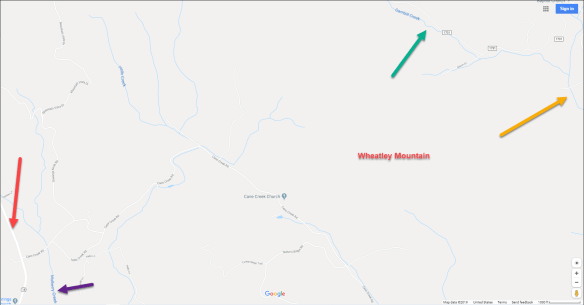
On this map, we see Sparta road with the red arrow, Mulberry Creek with the purple arrow, Gambill Creek with green and the Reddies River with tan. Sebastian Road is just to the south as is Harrold Mountain.
Based on the various deeds and descriptions, Wheatley Mountain appears to be this piece of heavily forested land.

This aerial map of the entire neighborhood takes into consideration everything we know from the various deeds. Vannoy Road is in yellow at left. Michael’s neighbor was Andrew Vannoy.
Vannoy Road intersects with Sparta Road near McGrady and Jacob McGrady bought Michael’s land when he sold.
The Wheatley family owned land between Roaring River and the top of the mountain. The mustard arrows at right track the West Fork of the Roaring River, with Gambill Creek shown in Green. The Gambills were Michael’s neighbors.
Harrold Mountain, towards the bottom, owned by John Harrold, adjoined Michael’s land on the waters of Mulberry Creek. Mulberry Creek, purple, tracks Sparta Road, red, all the way through the valley.
The grey arrow points to Sebastian Road near Harrold Mountain.
In 1810, we begin to see activity by the younger Michael McDowell, the next generation.
Feb 12, 1812 – Between Michael McDowell and Joseph Baker..$400…negro boy named Seaser, age 9. Witness James Waugh and R. Carson. Signed Michael McDowell, page 377
In both 1810 and 1813 a Michael McDowell purchases more land in Wilkes, including a one-acre lot in the town of Wilkesboro in 1813 (which was established in 1799). We don’t have records of the disposition of this land, but we know it can’t be Michael McDowell Jr., because he is in Lee County, Virginia in 1810.
Moving On to the Next Frontier
Yes, Michael McDowell Jr. moved once again, this time to the next outpost in the westward migration journey – Claiborne County, Tennessee on the Virginia border with Lee County.

Michael’s no spring chicken, and he’s starting over at age 63 in a place that can only be termed inhospitable.
Another chapter closes, and a new one opens. What lies ahead?
A place aptly named Slanting Misery.
______________________________________________________________
Disclosure
I receive a small contribution when you click on some of the links to vendors in my articles. This does NOT increase the price you pay but helps me to keep the lights on and this informational blog free for everyone. Please click on the links in the articles or to the vendors below if you are purchasing products or DNA testing.
Thank you so much.
DNA Purchases and Free Transfers
- FamilyTreeDNA
- MyHeritage DNA only
- MyHeritage DNA plus Health
- MyHeritage FREE DNA file upload
- AncestryDNA
- 23andMe Ancestry
- 23andMe Ancestry Plus Health
- LivingDNA
Genealogy Services
Genealogy Research
- Legacy Tree Genealogists for genealogy research
Share this:

Discover more from DNAeXplained - Genetic Genealogy
Subscribe to get the latest posts sent to your email.
Hello Roberta,
Is it possible that the surname McDowell was spelled differently in the 1700’s in early Virginia. I would like to suggest that it may have been spelled “McDuell”. I believe that this survey/land entry may have been for Michael, Sr.
30 Jan 1754…….Michael McDuell 400 on a Branch of Black Water Rv.beginning at a white Oak with 4 chops in it in the Fork of sd Br. thence up both Forks & down the branch.
(Halifax, Pittsylvania, Henry, Franklin, and Patrick 1737-1770).
My forebear, a Rev War Patriot is buried at Callaway, VA. I recall when Smith Mountain Lake was created in Bedford Co…..many families lost their farms. It is very, very deep with tall pine trees still “standing” at the bottom.
If this is indeed your Michael, Sr., perhaps the spelling of the surname made him difficult to find.
Great article!
Kind regards,
Rebecca
Yes, that surely looks like him.
It would never have occurred to me to look in that book, especially since Blackwater is in Bedford. Who knew. I need to find this book. That would be Michael Sr. I wonder what happened to this land. I wonder if he lost because he died. I found no deed, but I don’t recall if I looked for McDuell.
Also, thank you!
Roberta, thank you for including the name of Andrew Vannoy and his location in Wilkes County. It jogged my memory of entering something about the family in my tree, and there he was! I had been copying Find a Grave links from children to parents as “placeholders” until I could check out connections, and see if I wanted to pursue a line further. Using that information in my Notes let me see if they really “fit” in all the intermarriages.
Andrew and his descendants are one of those distant connections in my daughter in law’s family, down through the Vannoy, Whittington, Faw, Church, and Ayers family. I love Ancestry’s description of Andrew, “paternal grandfather of husband of mother-in-law of 2nd great-uncle of daughter-in-law.” I always enjoy your blog, and posts, and webinars, but this was special! Thanks, again.
Willlodene
I just love it when things like this happen.
Inconsistent spelling seemed to be the order of the day. “Skinner Devaul” is spelled as “Skinner Duvall” later in the same document…
I kept waiting for the Caudles (Caudills) to enter the story!
Pingback: Michael McDowell Jr. (c 1747 – c 1840): Slanting Misery – 52 Ancestors #260 | DNAeXplained – Genetic Genealogy
Pingback: Isabel (circa 1753 – 1840/1850), Wife of Michael McDowell – 52 Ancestors #278 | DNAeXplained – Genetic Genealogy
Pingback: Michael McDowell (1747-1840): Children & Land Dispute Revealed in Chancery Suit 21 Years After His Death – 52 Ancestors #389 | DNAeXplained – Genetic Genealogy